Sizing up 362 US giant oil fields by basin type
Have the different types of basins in the US had any influence of the characteristics of the giant oil fields within them?
A study of giant oil fields by areas should yield some answers to this question. Unfortunately, the published information about the characteristics of 362 giant fields located in 29 basins in the US includes little more than location, proved acreage, reservoir thickness, reservoir depth, major reservoir lithology, type of trap, age of the reservoirs, and total reserves.
Although many discoveries have been made in the Gulf of Mexico in the 1990s, only a few qualify as giant fields with little or no information available to the author.
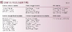
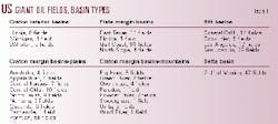
The 29 basins with 362 giant fields were modified from Klemme's classification into five types of basins. Table 1 shows the basin types and the number of giant fields in each basin.
Three craton interior basins, labeled 1 on the graphs, have 14 giant fields. To see if their present location had any effect, the craton margin basins with 17 basins and 135 giant fields were separated into two types, referred to as "plains," labeled 2, and "mountain," labeled 2A. There are nine basins and 108 giant fields in "plains" basins and eight basins and 27 giant fields in "mountain" basins. Four plate margin basins, labeled 3, have 107 giant fields, four rift basins, labeled 4, have 59 giant fields, and one delta basin, labeled 5, has 47 fields.
Basin acreage
Craton interior basins have a total of 106.3 million acres, "plains" basins cover 156.6 million acres followed by "mountain" basins with 74.6 million acres. Plate margin basins, the largest in size, have a total of over 255 million acres, rift basins cover 15.5 million acres, and delta basins cover 52 million acres.
Dividing the total acreage in each basin type by the number of giant fields in that basin yields the following:
One giant field for each 7.6 million acres in craton interior basins.
One field for each 1.5 million acres in "plains" basins, one field for each 2.7 million acres in "mountain basins."
One field for each 2.4 million acres in plate margin basins.
One field for each 262,712 acres in rift basins.
One field for each 1.1 million acres in the delta basin.
Proved acres in craton interior basins total 465,017 and average 33,216 proved acres per field. In "plains" basins proved acres total 5.7 million and average 52,972 acres, while in "mountain" basins the total is 300,800 proved acres and average 11,141 acres. Plate margin basins totaled 1.5 million proved acres with an average of 14,752 acres, rift basins total 289,881 proved acres and average 4,913 acres, while delta basins total 404,770 proved acres and average 8,612 proved acres.
Proved acreage in giant fields in craton interior basins is .44% of the total basin acreage, proved acreage in giant fields in "plains" basins is 3.6% of the total basin acreage, and proved acreage in giant fields in "mountain" basins is .4% of the total proved acreage.
Proved acreage in plate margin basins is .6% of the total proved acreage, proved acreage in rift basins is 1.8% of the total acreage, and proved acreage in giant fields in delta basins is .8% of the total acreage.
Giant fields, reserves by area
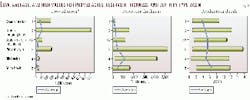
On Fig. 1 the three graphs show the number of giant fields and percent of giant field reserves, giant fields reserves, and percent of giant fields and average field reserves for each type of basin.
The giant fields and reserves curves follow each other very well. When one decreases the other decreases, when one increases the other increases. The 108 giant fields in the "plains" basins are the largest number of giant fields in one basin type followed closely by the 107 giant fields in plate margin basins. The 43.2 billion bbl of reserves found in plate margin basins were the largest followed by the 36.7 billion bbl in "plains" basins. Largest average reserves per field by basin type were 470.8 million bbl in rift basins followed by 403.8 million bbl in plate margin basins.
Fig. 2 shows the low, average, and high values for proved acreage, reservoir thickness, and reservoir depths for each type basin. In every case the average values are closer to the low values than to the high values, as in most cases the high values are the result of one extremely large value. The proved acreage values decrease from "plains" basins to delta basins. The thickness values show a large increase in rift basins and depth values show an increase in "mountain" and plate margin basins with the largest increase in delta basins.
Barrels per acre-foot calculations vary from 238 in craton interior basins to 63 in "plains" basins, 180 in "mountain" basins, 140 in plate margin basins, 172 in rift basins, and 117 in delta basins.
Lithology, trap, and area
The data are stacked on the following graphs, each line added to the line preceding it.
Fig. 3 shows the number of giant fields, reserves, and average field reserves by clastic, carbonate, and combination of clastic and carbonate lithology and basin type.
Craton interior, plate margin and both types of craton margin basins produce from all three lithologies.
Nine fields in craton interior basins have 83% of their reserves in carbonate lithologies. In "plains" basins 72% of their reserves are in 77 fields, while the "mountain" basins have 48% of their reserves in 14 fields with clastic lithologies. Plate margin basins have 61% of their reserves in 99 fields in clastic reservoirs. Rift basins have 96% of their reserves in 56 clastic and combination reservoir lithologies.
The reserves in 47 fields in delta basins are all in clastic lithologies. The largest reserves are the 26.4 billion bbl in carbonate reservoirs in "plains" basins. The largest average field reserves, 477.9 million bbl, are in combination reservoirs in plate margin basins.
Fig. 4 shows the average proved acres, reservoir thickness, and depth by lithology and type basin. The largest average proved acres are in combination lithologies, clastic and carbonate reservoirs, in "mountain" basins. The largest average reservoir thickness is in clastic reservoirs in rift basins. Average greatest depth of reservoirs are in combination clastic and carbonate reservoirs also in rift basins.
Fig. 5 shows the number of giant fields, reserves, and average field reservoirs by structural, stratigraphic, and combination structural and stratigraphic type traps for each type basin.
Giant fields in all basin types except delta basins have reserves in all three types of traps, structural, stratigraphic and combination structural and stratigraphic traps. Fields in delta basins are found only in structural traps.
Seventy-six percent of the reserves in 12 giant fields in craton interior type basins are in structural traps. Fifty-seven percent of the reserves in "plains" basins are in 75 fields in structural traps, and in plate margin basins 99 fields with 54% of their reserves are also in structural traps. Reserves in "mountain" basins are in stratigraphic traps in 20 fields with 60% of their reserves. Largest reserves are the 23.6 billion bbl in structural traps in plate margin basins. Largest average reserves are 3.3 billion bbl in combination traps in plate margin basins.
The average proved acres, average reservoir thickness, and average depth by type trap for each type basin are shown by Fig. 6. Stratigraphic traps have the largest average proved acres in "plains" basins followed by average proved acres in structural traps in "mountain" basins. The thickest average reservoirs are in structural and stratigraphic traps in rift basins. Largest average reservoir depths are in combination traps in plate margin basins followed by structural traps in "mountain" basins.
Fig. 7 shows the number of giant fields, giant field reserves, and average field reserves by reservoir age for each type basin. The ages used were general and include reserves in Cenozoic, Mesozoic, Mesozoic/Paleozoic, and Paleozoic reservoirs.
Giant field reserves in rift and delta basins occur only in formations of Cenozoic age. Giant field reserves in craton interior basins and "plains" basins are found only in formations of Paleozoic age. The only giant field basin types with reserves in three reservoirs of Cenozoic, Mesozoic, and Paleozoic ages are in plate margin basins with 38% of their reserves in four fields of Paleozoic age. The only three giant field reserves in formations of Cenozoic, Mesozoic/Paleozoic, and Paleozoic ages are in "mountain" basins with 78% of their reserves in Paleozoic reservoirs in 20 fields.
The averages for proved acres, reservoir thickness, and depth by age of the producing reservoirs in the various basin types are shown on Fig. 8. Largest average acres are in the Paleozoic formations in plate margin basins and smallest average acres are in Cenozoic reservoirs in rift basins.
Largest average thickness is in the Cenozoic reservoirs in rift basins, and the thinnest average reservoirs are in the Paleozoic reservoirs in the craton interior basins. Deepest reservoirs are in Paleozoic reservoirs in plate margin basins and the shallowest reservoirs are in Paleozoic reservoirs in craton interior basins.
Summary
Giant fields occur in almost all basin types, almost all proved acres, almost all reservoir thickness, almost all reservoir depths, almost all sedimentary lithologies, almost all type traps, and almost all major reservoir ages.
The largest basin type, the plate margin basins, have 38% of the total acreage, 18% of the proved acreage, 29% of the total fields, and 34% of the total reserves.
The next largest basin type, craton margin "plains," has 23% of the total acreage, 65% of the proved acreage, 30% of the fields, and 29% of the reserves. Following this are craton interior basins with 16% of the total acreage, 5% of the proved acreage, 4% of the fields, and 2% of the reserves.
The craton margin "mountain" type basins have 11% of the total acreage, 3% of the proved acreage, 7% of the fields, and 5% of the reserves. The rift basin type has 2% of the total acreage, 3% of the proved acreage, 16% of the fields, and 22% of the reserves. Last, the delta basin type has 8% of the total acreage, 4% of the proved acreage, 13% of the fields, and 7% of the reserves.
Surprisingly, the smallest basin in acres does not have the smallest number of giant fields or the smallest reserves in giant fields. Smallest total acreage is in rift basins, smallest proved acreage in giant fields is in rift basins, and the percentage of proved acres divided by total basin acres is next to the smallest in rift basins.
Giant fields in rift basins are the third highest in number, have the third highest reserves, the third largest barrels per acre-foot recovery factor, while the average field reserves and the barrels per acre recovery factor are the highest. The number of proved acres for each giant field by basin type is the lowest for rift basins. It would appear that as long as a basin is deep and has many layers of productive reservoirs the overall size of the basin may not be an important factor.
Comparison of proved acres in the two types of craton margin fields shows "plains" basins average 52,972 acres compared with 11,141 acres in "mountain" type basins. Reservoir thickness is not too different in the craton margin basins with an average thickness of 130 ft in the "plains" and an average thickness of 135 ft in the "mountain" basins. Average reservoir depth in the "plains" basins was 4,579 ft contrasted to 5,444 ft in the "mountain" basins. Average reserves in the "plains" basins are 339.8 million bbl/field compared with 253.8 million bbl/field in the "mountain" basins. Recovery factors in the plains basins are 63 bbl/acre-ft contrasted to 180 bbl/acre-ft in the "mountain" basins.
In the "plains" type basins 71% of their giant fields and 72% of their reserves are in carbonate lithologies and the "mountains" type basins 52% of their giant fields and 48% of their reserves are in clastic lithologies. The "plains" basins have 69% of their fields and 57% of their reserves in structural traps while the "mountain" basins have 74% of their fields with 60% of their reserves in stratigraphic traps.
Reserves and giant fields in "plains" basins are all in Paleozoic reservoirs whereas in "mountain" basins have 7% of their fields and 6% of their reserves in Cenozoic reservoirs, 18% of their fields and 16% of their reserves in reservoirs of Paleozoic/Mesozoic age, and 74% of their fields and 78% of their reserves in Paleozoic reservoirs.
Bibliography
Halbouty, M.T., "Giant oil fields in the United States," AAPG Memoir 14, Geology of giant petroleum fields, 1968, pp. 91-127.
Ivanhoe, L.F., and Leckie, G.G., "Global oil, gas fields, size tallied, analyzed," OGJ, Feb. 15, 1993, pp. 87-92.
Klemme, H.D. "Petroleum basins- classifications and characteristics," Journal of Petroleum Geology, Vol. 3, No. 2, 1980, pp. 187-207.
Klemme, H.D., "Field size distribution related to basin characteristics," Oil and gas assessment, methods and applications, AAPG Studies in Geology #21, 1986, pp. 85-99.
US fields with ultimate recovery exceeding 100 million bbl, OGJ, Jan. 25, 1999, pp. 76-77.
The author
F.R. Haeberle, a consulting geologist, moved to Delaware, Ohio, after 20 years in Dallas. He has worked for Standard Oil Co. of Texas, Atlantic Refining Co., Mobil Oil Corp., Mayfair Minerals, and J.J. Lynn Oil Division. He holds BS and MS degrees in geology from Yale University and an MBA degree in finance from Columbia University Graduate Business School. E-mail: [email protected]


