SOUTH ATLANTIC GEOLOGY-2 - Deciphering turbidites on seismic key to understanding basins off Africa, Brazil
This is the second part of an article designed to review some of the key concepts that relate to the geology of deepwater basins in the south central Atlantic Ocean.
The first part contained a review of economic ingredients as well as key relevant elements including the rift, continental breakup, and petroleum systems features (OGJ, Mar. 19, 2001, p. 30).
The quality of modern seismic data in deep offshore basins along continental margins in the South Atlantic Ocean is impressive.
Using 3D seismic data, each sand body in Tertiary sediments may be picked out in detail, though the same is not always true of the Upper Cretaceous as giant Roncador field off Brazil proved.
Using extracts of seismic sections presented in two IHS Energy Group deepwater reports it is possible to show that the emplacement of the present-day drainage system took place after the epirogenic Senonian tectonic upheaval, with the major exception of the Amazon Cone.
It is important to bear in mind the relative importance of the different zones feeding turbidites between the Cretaceous and the Tertiary. For example, the first clastic influxes on the Congo fan, though very small, are recorded as Senonian (Iabe), while Senonian sediments from the Ogooue of Gabon were much greater and comparable to the Tertiary.
The present-day arrangement was reached by the Middle Eocene. The turbiditic sandstone accumulations stemming from these drainage systems represent less than 10% of the total sediments deposited in these zones, with the remaining sediment consisting of pelagic clays. Two different types of turbidite accumulations may be recognized: the shelf-fed turbidites and the submarine cone turbidites.
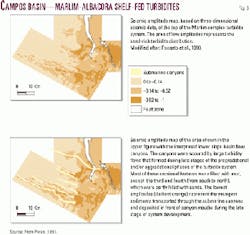
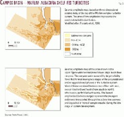
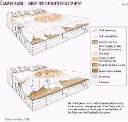
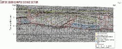
The shelf-fed turbidites are deposited on the lower slope. Coastal sands, deposited on the shelf by small rivers during periods of high water levels, are redistributed during low water level by upper slope canyons and deposited on the lower slope at the canyon mouth (Figs. 3, 4).
This system predominates in the South Atlantic of Brazil due to the dominant geographical configuration in place since the Cretaceous, the Coastal Cordillera, which stops the great interior rivers from reaching the sea. Erosion of this cordillera washed considerable quantities of sands onto the shelf, from where they were carried out to become the vast zones of shelf-fed turbidites, many of which are unexplored.
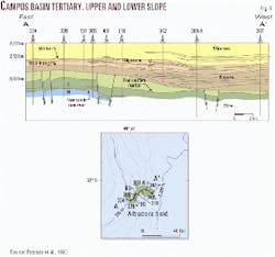
The resulting landscape is a shelf border and an upper slope, sliced in places by small canyons during phases of low water and/or uplift. During these periods all the sands deposited on the shelf at high water were remobilized through the canyons, leaving the upper slope barren. These canyons finish abruptly on the lower slope, where layers of turbiditic sandstones are formed, generally with good trapping upstream since most of the upper slope canyons have subsequently been filled with limestone (Figs. 3, 4). This phenomenon is repetitive and tends to shift in the Oligocene to Pliocene towards the abyssal plain by accretion (Fig. 5).
This shelf-fed turbidite mechanism is also found in the African deepwater offshore. Even though obliterated by later gravity tectonism, the Ceiba reservoir corresponds to exactly the same pattern of shelf fed turbidites.
In contrast, the spectacular deep cones of the Congo or Amazon fans stem from the detritus collected by the rivers on their journey to the sea from the vast continental interiors. This detrital mass crosses the upper shelf through canyons, shedding certain nonoil-generating sand bodies on the upper slope before regrouping in monumental sandy channels in the lower slope. The whole body is coated in an enormous mass of pelagic clay that progrades to the open sea.
At this point rapid submarine ocean currents strongly affect the distribution of the turbiditic sandstone bodies. The currents are strong enough to erode the Santos abyssal plain and divert the turbidite currents to the north of the Congo fan 200-300 km. The Batanga turbidites of the Port Gentil basin are famous for this "en chaussette" (sock) shape. This can all be seen on seismic records from the area, as discussed briefly below.
The deep canyons of the outer shelf occur just south of the present-day Congo river mouth straddling the coastal zone. The fan has widely prograded since the Lower Tertiary, and today's shelf is situated on top of the Lower Tertiary slope. The proximal turbiditic sandstone lenses are abundant in Blocks 1 and 3, above all in the Oligocene, but with no commercial value.
The bypass zone of upper slope (Louisiana-type) is the Bengo area, where an enormous mass of clay smothers a few rare sand lenses. Then, abruptly, we find ourselves at Girassol field and the deposits from the great sand channels of the lower slope, forming the prolific outer crown of the Congo fan.
Two examples of how local peculiarities can unexpectedly change a generally hostile environment to generate the formation of a local "oasis" are given below.
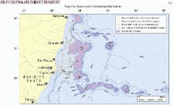
In Brazil, from the Campos basin to the Amazon cone, the shelf is very narrow and the slope plunges abruptly to 4,000 m of water as the Atlantic opening has brought oceanic crust very close to the shoreline and with it a strong thermal subsidence. But in the Espirito Santo basin the slope widens as it skirts around the submarine mud volcanoes of the Abrolhos and South Charlotte basins (Fig. 6).
These mud volcanoes were formed between the end of the Senonian and the Lower Tertiary and have locally emerged since the Lower Tertiary. They have had a ponding effect against the detritus flowing through the multiple canyons of the upper slope at the end of the Cretaceous to the early Tertiary (Regencia, Mucuri). This detritus remains trapped against the impassable barrier.
This gave rise to a local progradation of the shelf and, since the start of the Tertiary, the total filling of the zone between the coast and the submarine volcanoes. So instead of transiting to the abyssal plain the shelf-fed turbidites were deposited here, leading to optimum source rock burial. This example clearly illustrates the individual nature of petroleum plays.
A second example of an 'oasis' can be found in the Sergipe basin. This shows how even in unfavorable conditions, with oceanic crust very close to the coast and, thus, a sharp slope, strong clastic influxes from the San Francisco River have succeeded in creating turbiditic accumulations on the lower slope in 2,250-3,000 m of water.
These accumulations are probably highly rich in sandstone reservoirs. They are unexplored, but the discovery of oil in similar turbidites on the upper slope is a reminder of what we know about the Campos basin and the Congo fan.
Structure
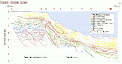
The second element in trapping is structural development. In the deep offshore structures are largely controlled by gravity sliding provoked by the steep dip of the slope and the very plastic character of the essentially clayey deposits. It is worth examining the difference between a salt zone (Fig. 7) and one without salt or with a very narrow strip of continental basement limited to the shelf, with the slope on the oceanic crust (Fig. 8).
The post-rift base of the salt has effectively enlarged the gravitational effects to the point of creating a Cretaceous rafting series, very often over several tens of kilometers on the upper slope (the rafted Albian blocks of N'Kossa), and the formation on the lower slope of giant anticline structures (Figs. 7, 9).
In some regions, the most spectacular being the Kwanza basin in Angola, the Cretaceous rafts are separated by intervals of 10 or even 15 km, where Tertiary fill gives anticlines solely composed of Tertiary sediments lying directly over the unconformity on top of the rift series, with no Cretaceous.
Gravity sliding started in the Upper Albian on the upper slope, reaching the lower slope in the late Cretaceous to the beginning of the Tertiary. The resultant structures are characteristic to each side of the Atlantic margin: the trained eye can tell on seismic if a given structure belongs to the Brazilian or African side and to which part of the slope, shelf, or abyssal plain (see Fig. 9 for example). The complexity of detail is considerable-one structural zone giving way rapidly to the next or a Tertiary anticline passing laterally into a salt dome.
The last structural zone before the abyssal plain is the Salt Domes Province (Fig. 10), a dense zone of piercing salt domes, some still in play today, resulting in a salt accumulation thrust away from the lower slope towards the edge of the abyssal plain.
The timing of this evolution is of prime importance. In fact it is clear that:
- If the turbidites were laid down at the same time as the rafted structure was formed, the latter will control the sand deposits (as in the Eocene turbidites of Fig. 9);
- If the rafting occurred later than the turbidite deposits, structural traps will dominate (as in the Cretaceous turbidites of Fig. 9);
- If rafting was completed when the turbidites were laid down the trapping will be highly stratigraphic, with a wide dispersion of sandy layers above a number of 'dead' structures (as in the Upper Tertiary of Marlim in Fig. 9).
In the absence of salt, the structuring of the margin is controlled by reactivation of transcurrent faults and slumping (Fig. 8). The upheavals related to the slumping phenomena express themselves in the region of Ceiba by the formation of olistostromes, first in the Senonian but mainly developing in the Lower Tertiary to Middle Miocene. The presence of olistostromes can introduce different potential seals into the stratigraphy, and in addition the topography of the olistostrome surface can help to 'pond' potential reservoirs in subsequent turbidites.
Conclusions
The few examples given here show that exploration in the deepwater offshore is only just beginning and that a lack of understanding of the petroleum geology will lead to failure and discouragement.
It is clear that the two dry holes drilled in deep water off northern Gabon are close to highly prospective areas. In order to be successful it is important to know what one is looking for and to be able to recognize it on a seismic section, where what one sees is often considerably different from modeling based on general concepts.
For what happens next in this story of ever deeper water exploration-the ultradeep offshore of Gabon, for example-the two reports can provide answers based on in-depth knowledge of West Africa and Brazil. A knowledge of the geology of Marlim is applicable to certain regions of Angola just as the Congo fan sheds light on the petroleum geology of the Amazon fan remarkably well.
