Greenland Fylla drilling details emerge
Greenland authorities and Statoil have released more details on the Qulleq near-Arctic exploration well drilled on the Fylla prospect off the southwest coast.
Qulleq 6354/4-1, the first exploratory well drilled off western Greenland in almost 25 years, was a dry hole at TD 2,937 m below sea level. The deepest part of the well, however, demonstrated "the presence of sandstone units of Late Cretaceous age," said Greenland's hydrocarbon exploration information service.
The license group consists of Statoil and Phillips Petroleum Greenland AS each 38.25%, Greenland's state Nunaoil AS 15%, and DONG Gronland 8.5%.
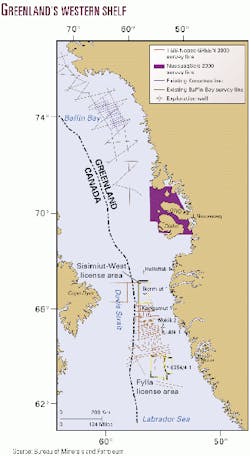
Meanwhile, seismic activity picked up west of Greenland in mid-2000 with three vessels operating. A licensing round is planned in the area in mid-2001.
TGS-Nopec gathered more than 6,300 km of seismic data between the Fylla and Sisimiut-West license areas. That continued mid-1999 activity and brought total acquisition to more than 9,000 km. It also acquired three regional tie lines in adjacent Canadian waters.
Nunaoil acquired 1,200 line km of proprietary data on the Sisimiut-West license for the group led by Phillips.
The Bureau of Minerals and Petroleum (BMP) in Nuuk funded a seismic survey in Baffin Bay designed to infill the existing regional Kanumas survey to achieve denser coverage of the central Melville basin.
Geological Survey of Denmark and Greenland (GEUS), Copenhagen, and the University of Aarhus acquired more than 2,700 km of high resolution seismic data in 18 days over the shallow part of the Nuussuaq basin in coastal waters around Nuussuaq.
Greenland launched a nomination period for the licensing round. The round, to open in mid-June and close in late 2001, is to cover most of the western continental shelf between 63° and 68° N. Lat., a region similar in size to the North Sea Central graben-Viking graben province. Nominations are due by Mar. 26, 2001.
Qulleq results, operations
Well results show that seismic cross cutting reflectors or prominent flat spots were not related to hydrocarbon charge, said Anon Spinnangr, Statoil exploration manager (OGJ, Aug. 22, 1994, p. 79).
The drilled Cretaceous succession comprised only the Upper Cretaceous marine sediments, and the well did not fully penetrate the Cretaceous section, Spinnangr said.
The Statoil group is pressing analysis of seismic and well data.
Statoil asked that the deadline for declaring whether to proceed in the second subperiod of the license to the BMP be extended to Mar. 15, 2001, from Dec. 15, 2000.
The West Navion drill ship spudded July 10, 2000 in 1,152 m of water 140 km west of Nuuk. Completion was announced Sept. 11.
A reported four weeks' down time was due mostly to blowout preventers and the wellhead, Spinnangr said. Statoil's ice management plan was effective, and downtime due to icebergs approaching the drill ship totaled 33 hr. Waves were not nearly as harsh as expected, he said.
Spinnangr did not reveal final well cost. Statoil's budget was $25 million for a dry hole, including site surveys, slightly higher than what the company is used to off western Norway.
"A major factor here was that we had to use a quite conservative well design to minimize all operational risks as this was the first well in the basin. Based on what we know now, we will be able to drill future wells in the basin at a significantly lower cost," Spinnangr said.
Statoil could have drilled the well without the office it set up in Nuuk, he added. It modeled the effects of a blowout, had no problems with health, safety, and environmental matters, and kept in contact with international environmental groups such as Greenpeace.

