UK changes coordinate system west of Britain
Through a combination of officially declared coordinate systems and transformations, petroleum industry users can now unambiguously merge positional data throughout the UK and its continental shelf (UKCS).
This provides an important step in ensuring the spatial integrity of offshore geotechnical data.
On Dec. 21, 1999, the London and Edinburgh Gazettes, both legal instruments of the UK government, published pertinent information provided by the Oil & Gas Licensing Division of the UK Department of Trade & Industry (DTI).
This information, which is especially pertinent to the West of Britain, clarifies its position concerning interpretation of existing and future petroleum license boundary coordinates. After Jan. 1, 2000, all data must comply with this notice.
The problem
Increasing UKCS activity west of Britain led the UK Offshore Operators Association (UKOOA) Surveying and Positioning Committee and the Hydrographic Office and Ordnance Survey to review the geographic coordinate system used to define petroleum license boundary coordinates.
These coordinates, previously referenced to "European Datum" and generally taken to mean ED 50, adequately described positions in the North Sea. Geodesysts, however, recognized that unitization activities west of Britain would eventually encounter serious difficulties in defining oil and gas field boundaries if this system remained unchanged.
The solution
The working group and the DTI chose a pragmatic approach by leaving the British and Irish National Grids in landward areas intact. In seaward areas, however, the previously ambiguous position has been clarified.
Where the ambiguity in the term European Datum is small, typically less than 5 m, and coincides with areas of mature UKCS petroleum activity, the coordinate system in use by the majority of the industry has been adopted.
On the other hand, where the differences in the interpretation of European Datum can introduce significant positional shifts, ranging from 10 to more than 1,000 m, a system considered to be coincident with the satellite navigation Global Positioning System (GPS) has been adopted.
Thunderer Line
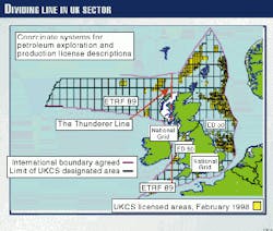
A dividing line, dubbed the Thunderer Line, was chosen at longitude 6°W in European Datum 50 (ED 50) terms (Fig. 1). This dividing line coincides with a Universal Transverse Mercator (UTM) zone boundary; hence, the number of projected coordinate systems recognized by the DTI for offshore mapping purpose, will remain at five.
East of the Thunderer Line lies the majority of the more mature exploration and production activities. At the level of positional uncertainty in this region, no business justification can be provided for disrupting current practices.
In this area, ED 50 is defined relative to the European Terrestrial Reference Frame 1989 (ETRF 89) and the GPS World Geodetic System 1984 (WGS 84). This system utilizes accepted industry transformation methods and transformation parameter values with consistency issues preferred over absolute accuracy.
West of the Thunderer Line, few data exist, and as yet, no oil and gas production. Thus, the adoption of a technically preferred system is acceptable and encouraged before such activities take place. Here, the term "European Datum" is clarified as ETRF 89.
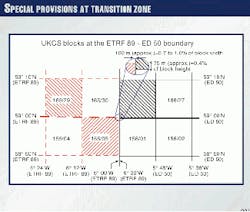
The ETRF 89 graticule is offset from the ED 50 graticule by about 75 m north-south and 100 m east-west. Because these offsets vary slowly with changing position, a zone of discontinuity in the quadrant and block system along the Thunderer Line is noted (Fig. 1).
Fortunately, coordinate conversion from one graticule to another poses no problem as long as the transformation details are clearly identified and if conversion programs can properly apply these transformations.
Thus, as a result of the Gazette notice, UKCS license boundaries to the east of the Thunderer Line will follow a latitude and longitude graticule based on the ED 50 coordinate system, while to the west of the Thunderer Line they will follow a latitude and longitude graticule based on the ETRF 89 coordinate system.
The exception is licenses that abut the Thunderer Line on their eastern side, where special provisions will ensure exact adjacency to licensees to the east based on ED 50 (Fix. 2).
For landward areas of Scotland, England, and Wales, the government will enact no change in the use of the Ordnance Survey GB National Grid and its geodetic datum OSGB 1936. This goes for landward areas of Northern Ireland as well, where mapping parameters will continue to use the Irish National Grid and its geodetic datum TM 65.
In addition to declaring the new geographic coordinate systems, the Gazette also provides pertinent transformations applicable for petroleum purposes between the ED 50, ETRF 89, OSGB 36, and WGS 84 systems.
Ireland
Because Ireland is also located west of Britain, a similar level of uncertainty is present in Ireland's Petroleum Administration Department (PAD, the Irish counterpart to Britain's DTI) petroleum license-boundary coordinate definitions. This problem is compounded by a less-prescriptive application of coordinate transformation parameter control exhibited by Irish Offshore Operators Association (IOOA) than which is maintained by UKOOA on its operators.
As Ireland has no simple mechanism for the publication of legal instruments, an Act of Parliament is required. It is understood that the PAD is currently investigating a clarification of its license descriptions with a possible implementation date of Jan. 1, 2001.
Guidance
Recognizing that the industry will require assistance and guidance concerning data-handling issues, the UKOOA Surveying and Positioning Committee has released guidelines provided in "Guidance notes on the use of coordinate systems in Data Management on the UKCS."
This document provides technical information for data users and can be downloaded at the UKOOA or DTI websites (www.ukooa.co.uk; www.og.
dti.gov.uk).
The full text of the Gazette notice, including the transformations applicable for petroleum industry use between the declared geographical coordinate systems-WGS84, ED50, ETRF89, and OSGB36-can be found within this document.
Acknowledgment
The author wishes to thank his working party colleagues Chris Carleton, Head, Law of the Sea, UK Hydrographic Office; Phil Davies, geodetic advisor for the Ordnance Survey of Great Britain; Charles Keiller, head of Geophysical Acquisition and Surveying, Enterprise Oil; and Roger Lott, Head of Survey, BP Exploration for their assistance in preparing the original recommendations to the DTI, and the members of the UKOOA Surveying and Positioning Committee for their contribution to the UKOOA guidance notes.
The Author
Richard Wylde is managing director of SIMA Consultancy Ltd., London, a company specializing in geomatics and geoscience consultancy. He is a fellow and a past president of the Land and Hydrographic Division (now called Geomatics) of the Royal Institution of Chartered Surveyors, representing them as an active member of the UKOOA Surveying and Positioning Committee.
Wylde has 24 years of experience in surveying and geodesy within the oil and gas industry. He acted as Industry representative on the Working Party charged with advising the DTI on coordinate systems for use on the UKCS.


