New concepts point toward oil, gas potential in Nicaragua

As a part of the process to open the Pacific and Caribbean margins of Nicaragua for licensing, Instituto Nicaragüense de Energía (INE) has compiled and re-evaluated Nicaragua's petroleum data base, which was acquired during different exploration periods since 1930. This work has led to a better understanding of the petroleum geology of both margins, which offer encouraging potential for oil and gas accumulations.
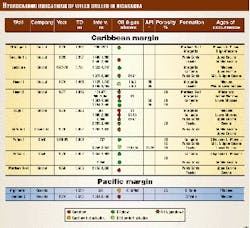
The available data base of the Pacific margin comprises geological, geochemical, and well log information gathered from six wells and 8,500 km of 2D seismic data. Two of the wells had gas shows (Table 1). Most of the seismic data were produced in the 1970s, and about 1,700 km were reprocessed in 1989 with good results. In addition 1,360 km of seismic and gravity data of good quality were acquired in 1989. In 1991-93, a regional sedimentological analysis was conducted in the Pacific offshore Sandino basin (Fig. 1), including an extensive geochemical-biostratigrahical study of the onshore and offshore Cretaceous and Tertiary sedimentary section.1
In the Caribbean, the exploration activity carried out in 1955-78 resulted in the acquisition of 25,000 km of seismic lines and the drilling of 24 offshore and two onshore wells. About ten of these wells reported good indications of oil and gas, including a short-lived production of 350 b/d of 26° gravity oil at Perlas-1 (Table 1). Bioscip2 appraised the Caribbean platform's hydrocarbon potential in 1987, and Martinez et al.3 summarized it in 1991. The Beicip study included interpretation of 18,000 km of seismic data, reservoir characterization from well tests and log information, biostratigrahical and geochemical analysis of well samples, and a depositional environment approach.
Fugro-Geoteam acquired a regional, nonexclusive 2D seismic survey of 3,097 km in July 1999.
Nicaragua tectonic evolution
Nicaragua is at the southwestern edge of the Caribbean plate and belongs to the island arc system of southern Central America, where the Cocos Plate is subducted under the Caribbean Plate along the Middle American Trench (Fig. 1).
Geologically, Nicaragua forms the southern part of the Chortis Block,4 which originated at the western margin of the North American Plate prior to the Cenozoic time.5 6
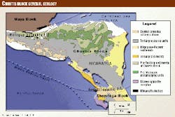
In the early Tertiary, this block was separated from the North American plate and incorporated with the Caribbean western margin along the Motagua-Polochic strike-slip fault zone (Fig. 1). The Chortis Block comprises two types of Mesozoic basement terranes, and it is important to understand the distribution of these terranes in order to predict the occurrence of Late Cretaceous source and reservoir rocks.
- The northern part includes dominantly low-grade metamorphic rocks and Cretaceous plutons. Early Cretaceous intrusive rocks have also been encountered in some wells in the northern and central Caribbean shelf area of Nicaragua. This crystalline basement is unconformably overlain by an Upper Triassic-Lower Jurassic sedimentary sequence.7 These rocks are extensively exposed in southern Guatemala, El Salvador, Honduras, and northern and central Nicaragua.
- In central and southern Nicaragua, a Cretaceous accretionary complex, the Nicoya Complex, is found in wells and outcrops along the Santa Elena-Hess Escarpment fault zone.
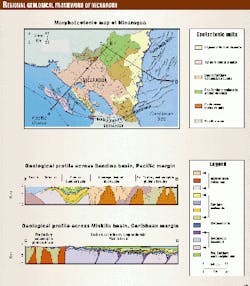
The tectonic interaction between the Chortis Block, the Chorotega Block to the south, and Maya Block to the north, combined with plate convergence, resulted in a complex evolution of the Nicaraguan island arc system (Fig. 2).
Geological evolution of basins Pacific margin, Sandino basin
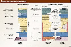
The Sandino basin was formed in the Cretaceous as a typical fore-arc basin, and it hosts approximately 10 km of Cretaceous and Tertiary sediments (Fig. 3). The sediments of the outer arc were deposited on the Nicoya Complex ophiolitic rocks. This rock assemblage consists mainly of pillow lavas, ultramafic bodies, volcanic agglomerates and breccias, and the corresponding pelagic cover: radiolaritic cherts, volcaniclastic rocks, and black shales.
The oldest sediments unconformably overlying the basement, are mostly Cretaceous-Paleocene distal onlapping turbidities and pelagic limestone, which are well exposed in the Rivas Isthmus.
In the Early Paleocene, the southern segment of the Chortis Block became coupled with the Chorotega Block along the Santa Elena-Hess Escarpment fault system, which continues along the periphery of the outer arc (Fig. 2).
In the Early Eocene, slow basin subsidence and a high turbiditic sediment influx from the island arc east of the basin allowed the sedimentation to surpass the outer arc, and sediments possibly draped the inner trench slope.
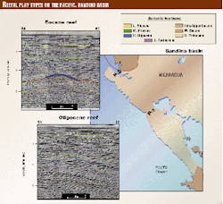
In the Middle Eocene, further accretionary processes resulted in additional growth of the outer arc. Concomitant strong subsidence in the whole fore-arc region led to deposition of a thick package of prograding turbidites. In the Late Eocene, a strong reactivation of the Santa Elena-Hess Escarpment system produced the formation of a basin- wide unconformity and provided conditions for local carbonate build-ups along the outer arc (Fig. 4). Compression due to subduction resulted in the formation of a fold belt, parallel to the trench, in the Rivas Isthmus. The further formation of an extensional fault system in this onshore region allowed the emplacement of intrusions in the Late Eocene.
The sea level drop in the Oligocene (30 mya) provided the establishment of the platform conditions that prevailed in the Neogene time, with development of local carbonate build-ups in the northwestern sector of the outer arc. In the Miocene, compression and uplift of the Rivas Isthmus, accompanied by an intrusive activity, formed anticlinal features cored by shale diapirs. In the Upper Miocene and up to the Present, a platform siliciclastic depositional system prevailed, with the influence of local deltas. The eastern parts of the basin were uplifted along a coastal flexure, and the whole Tertiary section is outcropping along the Pacific coast.
Miskito basin
In the Caribbean margin of Nicaragua, the Miskito basin contains a 4-10 km thick section of Cretaceous and Tertiary deposits (Fig. 3). Its detailed tectonic development is not well known because of the poor quality of the old seismic data. Interpretation of the new data will add information important to understanding the geology of the basin.
Towards the north, the continental basement terrane consists of low-grade, pre-Mesozoic metamorphic rocks and Cretaceous granitic plutons.8 In the central and southern region, a transitional to oceanic type of basement is dominant.
In the continental basement terrane, Cretaceous sediments outcrop in northern Nicaragua and Honduras, but they have not been drilled in the Miskito basin off Nicaragua.
Intense volcanism along NE-SW tensional features prevailed in the entire Paleocene and part of the Eocene, and volcaniclastic turbidites were deposited in the basin.
Two major transverse faults, the western extension of Pedro Bank and the Santa Elena-Hess Escarpment fault zone, seem to control the tectonic development of the Caribbean shelf in the Early Tertiary (Fig. 2). Both structures are considered to be remnants of paleosubduction zones and transcurrent features active during Cretaceous and Tertiary times at the boundary of a continental domain in the north and an oceanic domain in the south.9
The interaction of these two main faults in the Early Eocene resulted in the formation of a series of en echelon, NE-SW trending horsts and grabens.
Carbonate platform deposits and occasionally bathyal environment proceeded in the Eocene with some volcaniclastic influx in the south. The lithologies are mainly massive and porous bioclastic carbonates with some reefal influence.
In Oligocene and Miocene times, a continental to deltaic system was developed to the northwest, and clastic sediments prograded into the carbonate platform in the southeast. Shallow-water deposits and local reefal development were dominant in the Miocene to Recent period.
Next week: Petroleum potential and a peek at new seismic data.