Cuba deepwater exploration opportunities described in southeastern Gulf of Mexico
The Cuban government recently decided to offer opportunities to foreign companies for petroleum exploration in the deepwater area of the Cuban Exclusive Economic Zone (EEZ) in the southeastern Gulf of Mexico, including the western Straits of Florida, and in the northwestern Caribbean Sea.
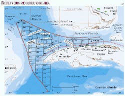
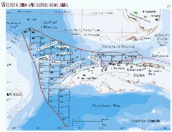
This part of the Cuban EEZ encompasses some 110,000 sq km and has been divided into 59 blocks of approximately 2,000 sq km each (Fig. 1). Contracts offered are of the production-sharing type.
As with the available shallow marine and onshore acreage in Cuba, the timeframe of the deepwater acreage offering is open-ended, and interested companies are free to make arrangements to examine data and commence negotiations with state oil company Cubapetroleo (Cupet) at any time.
In preparation for the acreage offering, Cupet contracted Compagnie Générale de Géophysique (CGG) to reprocess 1,650 line-km of 1980s-vintage regional 2D seismic data and to acquire and process 7,332 line-km of new speculative 2D seismic data as well as gravity data in the Gulf of Mexico portion of the acreage.
The reprocessed data are currently available for purchase. Acquisition of the new 2D survey was completed during September 2000; processing is under way and is scheduled to be completed and available as this article is published. The data may be examined either at the Cupet offices in Havana or through CGG's Non-Exclusive Survey Division.
An international workshop on the "Geology and Petroleum Potential of the Cuban Sector of the Gulf of Mexico" will be held during the IV Congress of Geology and Mining (GEOMIN 2001), Mar. 19-23, 2001, in Havana.
Location and bathymetry
Most of the 59 Cuban EEZ deepwater blocks are located north of Pinar del Rio and Habana-Matanzas Provinces of western Cuba, west of 81° W. Long. and extending out to the maritime boundaries with the US and Mexico.
The northwestern corner of the offered acreage coincides with the boundary of the Gulf of Mexico "Eastern Gap," an undesignated area outside the 200 mile territorial limits of the US, Mexico, and Cuba whose subdivision has yet to be negotiated between the three countries. The Cuban EEZ deepwater acreage is located some 100 km from the southernmost limit of acreage tentatively scheduled to be offered in the US Federal OCS Lease Sale 181 during December 2001.
Water depths in the Cuban deepwater EEZ range from 200 m near the Cuban coastline to more than 3,000 m in the Gulf of Mexico and Caribbean abyssal plains. A number of distinctive bathymetric features characterize the area. Abrupt continental shelf margins with associated talus slopes occur very near to the Cuban coastline and in the northwest along the Campeche Escarpment of the Yucatan Platform. The continental slope and abyssal plain are punctuated by a series of isolated bathymetric highs including the Catoche, Jordan, and Pinar del Rio (PDR) knolls.
Background
According to a report by Cupet and Robertson Research,1 the Jurassic to Recent geological history of Cuba can be divided into three main tectonic phases: extensional/passive margin, collisional, and transcurrent/extensional.
The extensional/passive margin phase began in the Triassic and-or Early to Middle Jurassic, associated with the rifting and breakup of Pangaea.
Compression began to affect Cuba during the Late Cretaceous as a result of the northeastward migration of the Cuban magmatic arc.
The Cuban fold and thrust belt and adjacent foreland basin formed during the Campanian-early Tertiary when the Cuban arc obliquely collided with the southern margin of the North American continent. Terminal collision took place during latest Paleocene-early Eocene2 and caused the obduction of volcanic arc-related rocks and ophiolites over the passive margin carbonates and evaporites of the Florida-Bahamas platform.
Following the cessation of collision in the early Tertiary, a sinistral transcurrent fault system developed to the south of Cuba (Cayman Trough) with associated NE-SW oriented wrench splays that transect the island. This transcurrent fault system has persisted to the present day and forms a portion of the boundary between the North American and Caribbean plates.
Contemporaneous with the early development of the transcurrent plate boundary, crustal collapse led to extensional structures being superimposed on the hinterland of the Cuban orogen. In addition, some of the collisional and transcurrent structures have been further modified by salt diapirism, especially in northwestern Cuba.3
Petroleum production in Cuba dates from 1881, when light oil production was established from Motembo field in the central part of the island (Fig. 1).
Cuba currently produces approximately 50,000 b/d of crude oil and 55 MMcfd of associated natural gas, mainly from a series of fields along a 100 km stretch of the northern coastline of Habana-Matanzas Provinces. The largest of these is Varadero field,4 with an estimated 2 billion bbl of oil in place.
Most of the present-day production comes from fractured Upper Jurassic and Lower Cretaceous carbonate reservoirs in structural traps of the Cuban fold and thrust belt.
With the application of modern drilling and completion techniques since Cuba opened its E&P sector to foreign participation in the 1990s, recently-drilled wells commonly have sustained production rates above 1,000 b/d. Some wells have reached 3,000 b/d.
Despite these successes, current production still only meets around 30% of Cuba's domestic demand.
Deepwater framework
The general geological framework of the Gulf of Mexico (including the western Straits of Florida) portion of the Cuban deepwater EEZ has been established based on the interpretation of a regional 2D seismic data set along with data from ten Deep Sea Drilling Project (DSDP)/Ocean Drilling Program (ODP) wells, data from onshore wells, and surface geological studies.
The following exploration trends/tectonic elements have been defined in the southeastern Gulf of Mexico portion of the Cuban deepwater EEZ (Fig. 1):
- Cuban fold and thrust belt.
- Cuban foreland basin.
- Buried Lower Cretaceous carbonate shelf margin of the Florida platform.
- Campeche Escarpment, the carbonate shelf margin of the Yucatan platform
- Gulf of Mexico open deepsea basin and knolls.
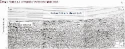
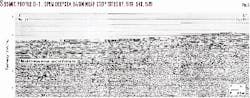
Seismic profiles A-E (Figs. 2-6), from the reprocessed 1980s-vintage data set, illustrate some of the major characteristics of these deepwater trends.
The Cuban fold and thrust belt of the northern coastal zone, with its proven hydrocarbon system, has a vast unexplored portion extending 30-50 km northward into the Gulf of Mexico and Straits of Florida and along the entire northern coast of the island. Water depths in this trend vary from 0 to nearly 2,000 m.
The fold and thrust belt involves up to 12 km in thickness of Jurassic-Santonian carbonates and Campanian-Lower Eocene synorogenic sedimentary rocks.
Quality of the older 2D seismic data in the fold and thrust belt is fair to poor, with the lack of coherent reflectors being attributed to structural complexity. However, a strong velocity contrast exists between the synorogenic clastic rocks and the underlying thrusted carbonate section, and as such the structural configuration of the top of the allochthonous section is well resolved, even on the older seismic data (Figs. 2, 3).
The southern end of seismic profile A-A' is located just offshore from the area of Puerto Escondido field, the site of some of the most prolific of the recent discoveries made in Cuba. Potential traps and reservoirs are expected to be the same as those in the onshore portion of the trend that is already being developed, as described above.
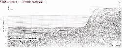
The heretofore unexplored Cuban foreland basin, where 7-8 km of Upper Cretaceous-Eocene terrigenous clastic sediments were deposited on top of the Jurassic-Lower Cretaceous Gulf of Mexico passive margin carbonates, is located immediately to the north of the fold and thrust belt.
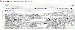
Profile B-B' (Fig. 3) shows the three most prominent and regionally extensive seismic reflectors within the foreland trend. The deepest of these reflectors is interpreted to mark the top of the Lower Jurassic synrift sequence, with a probable downward transition from marine carbonates to continental terrigenous clastics across this horizon.
Also prominent across the trend is the gulf-wide Middle Cretaceous Unconformity (MCU; also referred to as the Middle Cretaceous Sequence Boundary, MCSB),5 and another major unconformity in the middle Tertiary, possibly Late Eocene6 or Oligocene in age.
Basement-rooted normal faults typical of foreland basins, although not illustrated in any of the seismic profiles published here, have been observed on other seismic data sets7 and would provide one of the main potential trap types in this trend. These faults generally are downthrown to the south toward the thrust front. Significant stratigraphic traps are also possible: as the foreland basin fill dips regionally to the south, any pinchouts of coarse clastic intervals towards the north should constitute potential traps.
Reservoir facies in the foreland are expected to be predominantly coarse terrigenous clastics derived from the Cuban orogenic belt. Strong east-to-west ocean bottom currents (at least in paleo-water depths above 800 m) have apparently affected the Straits of Florida since the early Paleocene;8 these currents would have reworked and winnowed the younger portion of the foreland clastic sediments and further enhanced their reservoir quality.
The Lower Cretaceous carbonate shelf margin of the Florida platform trends into the central and eastern portions of the offered deepwater acreage, converging with the Cuban thrust front just offshore from Havana. The shelf margin is clearly identified on seismic data (northern portion of profile B-B', Fig. 3) by an abrupt change in dip of the MCU.
Within the Cuban EEZ, the margin was buried by foreland basin sediments during the Late Cretaceous and Lower Tertiary. A belt of forereef debris is expected to occur just southwest of the Lower Cretaceous margin, which may constitute an exploration play analogous to giant Poza Rica field in eastern Mexico. A similar play type exists along the Campeche Escarpment in the western portion of the area, as illustrated on seismic profile E-E' (Fig. 6).
The southeastern corner of the Gulf of Mexico open deepsea basin trends into the northwestern part of the Cuban EEZ. Water depths range to greater than 3,000 m.
Seismic profile D-D' (Fig. 5) shows a section of thin (approximately 1,500 m) Tertiary sediments overlying the MCU; the change in relief of the MCU observed on the right portion of this seismic profile demarcates the southern boundary of the open deep sea basin.
DSDP Site 535, which encountered oil in fractured carbonates below the MCU9 10 is about 10 km southwest of profile D-D'. The open deepsea basin is punctuated by a series of basement highs, or knolls, the flanks of which may provide stratigraphic trapping potential for hydrocarbons.
Seismic profile C-C' (Fig. 4) crosses the PDR Knoll and illustrates the pinchout of sediments against its flanks. Potential reservoir facies in this trend are distal terrigenous clastic turbidites derived from the Cuban orogen to the south, and carbonate turbidites and debris-flows shed from the Florida and Campeche escarpments and perhaps locally from the knolls.
Apart from the possible reservoir facies mentioned above, another perhaps more unconventional and controversial reservoir type could be widespread in the deepwater Cuban EEZ. In onshore Cuba, there are extensive outcrops of at least two carbonate breccia units, the Peñalver formation of Habana and Matanzas Provinces and the Cacarajícara formation of Pinar del Rio Province.
These two units appear to have the characteristics of a K/T boundary "cocktail" unit related to the Chicxulub bolide impact on the Yucatan platform. If these units are age-equivalent and indeed impact-related, and as such were derived from the collapse of the continental margins in the southeastern Gulf of Mexico and northwestern Caribbean, they may blanket much of the Cuban EEZ and could be excellent reservoirs.
The main productive carbonate breccia reservoirs in the Bay of Campeche offshore Mexico, such as at the supergiant Cantarell field complex, are now interpreted to have such an origin related to the Chicxulub impact.11
The existence of a viable, thermogenic hydrocarbon generating system within the deepwater area is confirmed by the presence of oil in DSDP Site 535 in the central part of the Cuban EEZ.9 A more regional extent of this and perhaps other hydrocarbon systems is suggested by the occurrence of hydrocarbons surrounding the Cuban EEZ (Fig. 1).
Established oil and gas production occurs directly south of and adjacent to the eastern portion of the EEZ, in the Habana-Matanzas trend, and to the north of the EEZ in the Sunniland Trend of South Florida.12 13 Oil seeps and live oil shows in wells have also been encountered in the onshore Pinar del Rio Province of westernmost Cuba and in wildcats drilled in the Florida Keys14 15 and Cay Sal Bank of the Bahamas.16
Highly organic-rich, oil-prone source rocks have been documented from Lower Cretaceous (Valanginian to Barremian) laminated limestones penetrated in DSDP Site 5359 within the Cuban deepwater EEZ. There is also evidence from outcrops in adjacent onshore western Cuba that various parts of the Lower Cretaceous as well as the Upper Jurassic passive margin section may be potential oil source rocks.17
The Jagua Vieja member of the Upper Oxfordian Jagua formation in the Sierra de los Organos and the correlative Francisco formation of the Sierra de Rosario to the east consist of black laminated shales with ammonite-bearing limestone concretions that commonly contain live oil in the ammonite chambers. Also, the Guasasa formation (Kimmeridgian-Cenomanian) in the Sierra de los Organos contains several black, micritic, pelagic limestone members which could also have source potential.
The Artemisa formation (Kimmerid- gian-Valanginian) of the Sierra de Rosario is partially equivalent to the Guasasa and is characterized by a strong petroliferous odor and bitumen-filled fractures. Somewhat more speculative is the possibility of lacustrine or paralic oil source rocks within the Jurassic synrift San Cayetano formation.
Model contract
Cupet is authorized by the Cuban government to explore for and exploit hydrocarbons in all parts of the territory of Cuba, including deepwater areas, either alone or in association with foreign partner(s). In the latter case, a production sharing contract legalizes the economic association between Cupet and its partner.
Each contract must be approved by government resolution and is protected by the Constitution and by the Law of Foreign Investment approved by the National Assembly during 1995. Any disagreements that cannot be resolved internally will be submitted to international arbitration and subject to the rules of conciliation and arbitration of the International Chamber of Commerce in Paris, France.
The Model Production Sharing Contract is considered as the basis for negotiations. The main elements of the contract, such as duration, work program obligations, and relative percentage of cost oil vs. profit oil, are to be determined via the negotiation process.
The foreign partner can dispose of its share of produced hydrocarbons as it desires; in the event the foreign partner's share is sold domestically, the foreign company will be paid at the current international market price. No royalties are collected for oil production, and there is no tax on exported hydrocarbons. Annual net profits from business transacted in Cuba are taxed at a rate of 30%.
Conclusions
The Cuban sector of the deepwater Gulf of Mexico (Cuban EEZ) has significant hydrocarbon exploration potential in a variety of trends.
An offshore extension of the productive Cuban fold and thrust belt, and its associated foreland basin, remain undrilled and constitute a probable major petroleum province of the future. Additional potential is foreseen in traps and reservoir facies associated with Florida and Campeche escarpments, around the flanks of basement high "knolls," as well as in the deep, open gulf basin.
Oil recovered from DSDP Site 535, in the central portion of the Cuban EEZ, confirms the existence of thermally-mature, viable oil source rocks even in the deepest water areas.
A newly-acquired regional 2D seismic data set will help to define the most highly prospective areas of the Cuban EEZ. This vast, 110,000 sq km area has been subdivided into 59 blocks that are available for licensing by foreign companies under production-sharing contract terms.
References
- Cupet-Robertson Research, "The geology and hydrocarbon potential of the Republic of Cuba," 1993.
- Bralower, T.J., and Iturralde-Vinent, M.A., "Micropaleontological dating of the collision between the North American plate and the Greater Antilles arc in western Cuba," Palaios, Vol. 12, 1997, pp. 133-150.
- Jamison, W.R., and Podruski, J.A., "Tectonic history of western Cuba," AAPG Bull., Vol. 84, No. 13, 2000.
- Tavares, D., "Principales características geológicas del campo Varadero, Cuba, y de su yacimiento de petróleo extrapesado," Oil & Gas Journal Latinoamérica, Vol. 9, No. 5, 1999, pp. 28-42.
- Buffler, R.T., "Seismic stratigraphy of the deep Gulf of Mexico basin and adjacent margins," in Salvador, A., ed., "The geology of North America, Vol. J, the Gulf of Mexico basin," Geological Society of America, 1991, pp. 353-387.
- Angstadt, D.M., Austin, J.A., and Buffler, R.T., "Deep-sea erosional unconformity in the southeastern Gulf of Mexico," Geology, Vol. 11, 1983, pp. 215-218.
- Angstadt, D.M, Austin, J.A., and Buffler, R.T., "Early Late Cretaceous to Holocene seismic stratigraphy and geologic history of southeastern Gulf of Mexico," AAPG Bull., Vol. 69, 1985, pp. 977-995.
- Denny, W.M. III, Austin, J.A., and Buffler, R.T., "Seismic stratigraphy and geologic history of Middle Cretaceous through Cenozoic rocks, southern Straits of Florida," AAPG Bull., Vol. 78, 1994, pp. 461-487.
- Katz, B.J., "Source quality and richness of Deep Sea Drilling Project Site 535 sediments," initial reports of the Deep Sea Drilling Project, Vol. 77, 1984, pp. 445-450.
- Schlager, W., Buffler, R.T., et al., "Deep Sea Drilling Project, Leg 77, southeastern Gulf of Mexico," Geological Society of America Bull., Vol. 95, 1984, pp. 226-236.
- Grajales-Nishimura, J.M., Cedillo-Pardo, E., Rosales-Domínguez, C., Morán-Zenteno, D. J., Alvarez, W., Claeys, P., Ruíz-Morales, J., García-Hernández, J., Padilla-Avila, P., Sánchez-Ríos, A., "Chicxulub impact: the origin of reservoir and seal facies in the southeastern Mexico oil fields," Geology, Vol. 28, 2000, pp. 307-310.
- Halley, R.B., "Setting and geologic summary of the Lower Cretaceous Sunniland rield, southern Florida," in "Carbonate petroleum reservoirs," Springer-Verlag, N.Y., 1985, pp. 444-454.
- Palacas, J.G., Anders, D.E., and King, J.D., "South Florida basin-a prime example of carbonate source rocks of petroleum," in AAPG Studies in Geology 18, "Petroleum geochemistry and source rock potential of carbonate rocks," 1984, pp. 71-96.
- Attilio, D.E., and Blake, B., "Petroleum potential, exploration possibilities of South Florida basin, Florida Keys," OGJ, Vol. 8, 1983, pp. 148-153.
- Applegate, A.V., "Principal oil fields in Florida and possible future oil and gas fields in the state and offshore," Interstate Oil Compact Commission Bull., Vol. 25, 1983, pp. 38-41.
- Tator, B.A., and Hatfield, L.E., "Geology of the Bahamas with evaluation of petroleum potential," Ministry of Development, The Bahamas, 1975, 591 p.
- Pardo, G., "The geology and petroleum prospects of Cuba," Petroconsultants/IHS Energy, 1992, 556 p.
The authors

Dr. Guillermo Hernández Pérez has been exploration manager at Comercial Cupet SA since 1991. He has been active in the petroleum industry since 1960 and also spent 10 years as a professor of seismic methods in the High Polytechnic Institute of Havana. He holds degrees in electrical engineering from the University of Miami and in geophysics from the University of Havana, Institut Français du Petrole, and Academy of Oil and Gas in Moscow.

Jon Frederic Blickwede is regional manager, Mexico, Central America and Caribbean for IHS Energy Group. From 1981-96 he was with Amoco Production Co. in New Orleans, Houston, and Caracas. He has since been manager of geoscience at The Andrews Group International, providing E&P consulting for Petróleos Mexicanos. He has a BS degree in geology from Tufts University and an MS degree in earth sciences from the University of New Orleans. E-mail: [email protected]