Seismic reveals new eastern Precaspian target
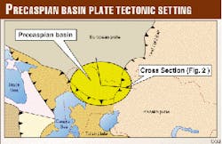
The intracontinental Precaspian basin is located at the triple junction of the European, Turan, and Kazakh plates (Fig. 1). It belongs mainly to the western provinces of Kazakhstan and was relatively well explored during Soviet Union times.
Its eastern margin is one of the most important oil provinces of Kazakhstan with numerous oil discoveries and oil fields from the Carboniferous up to the Cretaceous. In the past most exploration targets were pre-salt prospects and shallow structures overlying salt domes.
Basin development
During Permian time, when the European, Turan, and Kazakh plates collided, this region became an isolated intracontinental basin lying in the northern hemisphere between 20-30° N. Lat.1
Affected by Permian cyclic climate conditions well known from other basins of the same paleogeographic position like the Southern Permian basin of northwestern Europe, the sedimentation system is characterized by several cyclic sequences and facies variations.
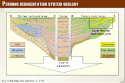
Three major facies developments can be distinguished2 (Fig. 2):
- Carbonates and evaporites in the northern and western part
- Evaporites in the center
- Fine clastic alternations in the eastern and southern part.
This facies differentiation follows a long-term, purely carbonatic development under open marine conditions at the outermost southeast corner of the European plate.
This carbonatic development started during the Early Devonian, when the whole area of the Precaspian basin of today was open to the Uralian Ocean to the north-northeast and to the Paleo-Tethys Ocean to the south-southeast. Then a short-term development of an active rift zone set in during the Middle Devonian in the center part of the Precaspian basin of today. This oceanization of the crust, with the formation of a basaltic window, is deduced from gravity data.
The influence of extensional movements ended in the Late Carboniferous just before the Kazakh plate collided with the European plate and the Uralides began to form.
The eastern part of the Precaspian basin became the foreland basin of the rising Uralian foldbelts.
After the following accretion of the Turan plate in the Lower Permian, this basin was separated from the Paleo-Tethys and had only a narrow connection to the northern Arctic Ocean. The water circulation in this intracontinental sea was reduced, and evaporation rates increased dramatically.
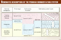
During the Kungurian period (about 5 Ma) several thousand meters of massive salt were deposited and filled up the deep basin in a relatively short time (Fig. 3). Then in the Upper Permian the basin began to shrink caused by the Uralide overthrust from the east, and an immense amount of molasse-type clastic sediments was transported into the basin while cyclic evaporation conditions endured.
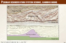
This input of clastics during Ufimian and Kazanian times onto the massive Kungurian tabular salt deposits formed huge fans. Caused by this overburden the underlying salt was synsedimentarily squeezed out and formed moraine-like salt upwellings at the front and the sides of the fans. These early salt accumulations were then only covered by thin sediment layers or were not covered at all. Younger clastic cycles were partly deposited unconformably above (Fig. 4).
Benefits from new seismic
Newly-shot as well as reprocessed seismic lines give strong evidence for the cyclicity and facies variations of the Upper Permian units from the eastern margin of the Precaspian basin toward its center.
Long-distance correlations are possible, although the whole area is affected by intense late halokinetic movements modifying older salt accumulations and forming young salt piercements through the Permian sediments.
Furthermore regional lines show the causal connection of the progressing Uralide thrust belt front and the prograding sedimentation system. The relation between Upper Permian tectonics and sedimentation is shown by the underlying Pre-Kungurian units, broken up by steep dipping thrust faults, and the unconformably overlying more or less undisturbed Triassic sediments (Fig. 5). These relations are strictly limited to the Upper Permian.
To reduce the exploration risk of reservoir development it is essential to recognize the differences between seismic reflection patterns of the Upper Permian reservoir units and the evaporitic nonreservoir units.
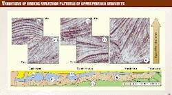
Seismic reflection patterns combined with results from several wells give evidence for facies variations, changing from the Early to the Late Upper Permian and from the thrust zone to the basin center (Fig. 5).
To understand these changes it is advisable to follow the different pattern variations from the thrust zone in the east basinwards to the west.
- The margin type (Fig. 5 Type M) close to the thrust zone is characterized by huge piles of high amplitude reflections representing megacycles of dense alternating clastic sequences often steeply dipping to the west.
- Basinwards in a transition zone the reflections at the top of the older megacycles become very strong, representing synsedimentary evaporitic layers, whereas the reflectivity within the megacycles decreases slightly (Fig. 5 Type T1), which gives evidence that the cyclic alternations are less striking and are dominated by fine clastic sequences.
- The younger cycles of the transition zone are developed as prograding wedges with distinct alternations of only clastic sequences, represented by high amplitude reflections (Fig. 5 Type T2). The coarser parts of these sequences were proven to have good reservoir conditions and are the target of the Upper Permian play.
- The oldest proximal post-Kungurian clastic sequences are often affected by halokinetic movements and are lying below salt dome overhangs so that their seismic characteristics are often masked and make them look like parts of the Kungurian salt domes themselves. The newly acquired and-or reprocessed seismic however shows that in many cases the salt domes only have mushroom-like shapes with narrow stems. The early post-Kungurian sequences now show much better visible layered reflections (Type B1). These Ufimian-Kazanian sequences represent the facies development from the pure Kungurian salt to cyclic alternations of fine clastics and evaporites.
- The younger innerbasinal post-Kungurian clastic sequences close to the Base Triassic unconformity show in principal reflection patterns comparable to Type T1 with harsh reflections at the top of the cycles and weak reflection zones below. Compared to Type T1 the cycle thicknesses are significantly reduced resulting in a very characteristic dense succession of strong reflections and weak zones (Type B2).
This type represents the late sedimentary cycles with reduced sedimentation rates of fine clastics and periodically intercalated synsedimentary evaporites.
Well results show that the seismic pattern Type T2 is the most promising one for exploration as it represents stacked reservoir-seal successions of prograding wedges or channel fills. Porosities range up to 20%.
A major exploration risk within this transition zone is to distinguish between:
- the alternations of poorly developed evaporites and fine clastics and
- the alternations of thick reservoir sands and fine clastics.
This is because their reflection characteristics are quite the same. The fact that the Upper Permian cyclic development is often subdivided by unconformities makes it easier to separate older evaporitic and fine clastic megacycles from younger predominantly clastic ones.
Clastic sedimentation model
To understand the phenomena described above it is necessary to create an evolution model that explains the effects of immense clastic sedimentation onto massive tabular evaporites. In a recently published sandbox model study, Ge et al.3 presented seismic lines and palinspastic restorations dealing with these conditions.
The seismic examples from the eastern margin of the Precaspian basin are in some cases directly comparable with the sandbox models from this study (Fig. 4). The experimental results may be used for the mechanical aspects of the sedimentation process, like fan deposition, salt expulsion, and salt erosion-redeposition.
In addition to this, climate derived aspects, like cyclic sedimentation and evaporation and synsedimentary tectonics, must be taken into account.
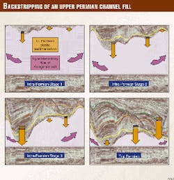
A palinspastic restoration of a seismic line perpendicular to the sedimentary transport direction of a huge fan illustrates the effects of the cyclic input of immense clastic sediments onto the underlying unconsolidated massive salt (Fig. 6).
Assuming that the sedimentation of this type of fan always took place just above-below sea level the increasing sedimentary load squeezed out the salt forming a channel of clastic sediments and moraine-like features of salt pillows to the front and to the sides (Fig. 6, stages 1 and 2).
This channelized fan continued to grow until all salt below the channel axis was gone and the clastics touched down onto the pre-salt layers (Fig. 6, stage 3). Then the channel axis began to move to the side, and again salt was expelled from below it (Fig. 6, last stage).
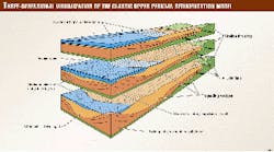
The development of the Upper Permian sedimentation system in its dependency from cyclic climate changes, tectonics, and salt movements is illustrated by a succession of three-dimensional models (Fig. 7).
The sediment type T2 (defined by seismic and well results) with its multiple stacked reservoir sands is represented by the frontal part of the prograding wedges and the associated channel fills (Fig. 7c).
Conclusions
In the light of new seismic results, the thick Upper Permian cycles of coarse and fine clastic sediments have become an additional exploration target on the eastern margin of the Precaspian basin.
A seismic derived geological model helps to identify and explore for promising reservoirs within a complex, halokinetically effected tectono-sedimentary framework.
Acknowledgments
The authors thank the geoscientists of Shell Temir Petroleum Development BV for numerous discussions and Veba Oil & Gas Kasachstan GmbH for the chance to publish this article.
References
- Voltchegursky, L.F., Vladimirova, T.W., Kapistin, I.N., and Natalov, L.M., "Evolution of the Caspian depression in Middle and Late Paleozoic," 1995 (translated).
- Volozh, Y.A., Volchegursky, L.F., Groshev, V.G., and Shishkina, T.Y., "Types of salt structures in the Peri-Caspian depression, Geotectonics, Vol. 31, No. 3, 1997, pp. 204-217.
- Ge, H., Jackson, M.P.A., and Vendeville, B.C., "Kinematics and dynamics of salt tectonics driven by progradation," AAPG Bull., Vol. 81, No. 3, 1997, pp. 398-423.
The Authors
Peter Gralla is a German professional geologist with 20 years of experience in international petroleum exploration. He is an expert on the Permian sedimentation system of the Southern Permian Basin-Northwest Europe. For 3 years he is chief geologist of Veba Oil & Gas Kasachstan GmbH. Since June 1999 he is TPO of the EAGE Petroleum Division. He obtained a PhD degree in geology from the University of Braunschweig. E-mail: [email protected]
Jürgen Marsky is a German professional geophysicist with more than 15 years of experience in international seismic interpretation. He has been working on different salt basins of the world. For 2 years he is chief geophysicist of Veba Oil & Gas Kasachstan GmbH. He obtained an MSc degree in geology from the University of Braunschweig. E-mail: [email protected]

