New Mexico's Orogrande basin merits reconsideration now
Much of south-central New Mexico hosts a Paleozoic basin that formed concurrently with the Delaware and Midland basins of southeastern New Mexico and West Texas. This basin, known as the Orogrande basin, hosts Pennsylvanian and older rocks that are productive in these other basins.
A previous paper written by the author and his late partner1 provided data on the potential of this basin. At that time in the mid-1980s only a few companies expressed an interest in the basin. Most of the industry ignored it, citing the belief that no reservoirs were present in the Orogrande basin.
The recently announced Harvey E. Yates 1 Bennett Ranch discovery well in Otero County has caused the author and others to reflect on the basin's potential and comments heard upon publication of the previous paper.
The well, which has an announced flow rate of 4.4 MMcfd of gas from a reservoir of Mississippian age, is on the eastern shelf margin of the Orogrande basin (OGJ, Aug. 17, 1998, p. 45). In addition, discoveries in the intermontane basins of the Basin and Range Province of Nevada, which has a similar tectonic history, also validate the author's belief that reservoirs with economic reserves still exist in the Orogrande basin.
Orogrande geology
The Orogrande basin most probably formed as a Pennsylvanian intracratonic downdrop basin in response to the tectonic activity that created the Appalachian-Ouachita uplifts.
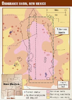
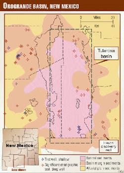
Fig. 1 shows the lateral extent of the Orogrande basin, both the area of deep basinal sediments and the marginal marine shelf sediments.
One of the major problems that the author has faced in his discussions about the Orogrande basin is the confusion between the Late Paleozoic tectonic feature known as the Orogrande basin and the Recent geographic feature known as the Tularosa basin.
The Orogrande basin is a Pennsylvanian and Permian age basin, while the Tularosa basin is a Tertiary age graben that formed as part of Basin and Range extensional faulting. The physiography of the area consists of broad, relatively flat, internally drained basins (bolsons) separated by fault block ranges subtending 5,000-7,000 ft of topographic relief. The area on Fig. 1 defined as the Tularosa basin is located within the green box. The Orogrande basin is a far larger feature that incorporates 10,000+ sq miles and is roughly the same size as the Delaware and Michigan basins combined.
Permian basin similarities
Because of its similarities with the Permian basin, and specifically the Delaware basin and its northwestern shelf, one can model the potential reservoirs in the Orogrande basin by developing analogs to productive fields farther east.
Reservoirs that may be found in the Orogrande basin are analogous to reservoirs in the Delaware basin. Examples include Wolfcampian (i.e., Vacuum and Abo reefs), the Upper Pennsylvanian (i.e., the Bough C of northern Lea County and Cisco of southwestern Eddy County), the Strawn (both sandstone and carbonate reservoirs), and the Atoka-Morrow channel sandstone, which is a prolific natural gas reservoir.
These reservoirs remained viable in the Delaware basin because they were not breached by post-tectonic activity. One of the arguments against exploration in the Orogrande basin is the belief, often published in the technical literature, that most of the reservoirs have been breached and diluted by fresh water as a result of Basin and Range faulting.
Detailed analysis of the previously drilled wells shows that the data do not support this contention.
Approximately 112 wells have been drilled in the Orogrande basin. Of this number, 29 wells have a TD of 1,000 ft or less and are not considered valid stratigraphic tests. Of the remaining 83 wells, 25 have had documented shows of oil or natural gas. Ninteen additional wells encountered salt water or brine suggestive of hydrocarbons in some updip location.
A total of 53% of all valid stratigraphic tests drilled in the Orogrande basin or its shelf encountered signs of hydrocarbons. This statistical analysis is significant, especially when compared to the data for most onshore productive basins now considered mature.
Detailed geoscience needed
One reason that reservoirs have not been found in the Orogrande basin is that the detailed geology and geophysics needed to reveal the subtle reservoirs present has not been done. The Basin and Range tectonic history imposed over the basin obscures the Late Paleozoic structures that formed during Orogrande basin time.
Seismic data are generally not available, and the data that have been collected are either of poor quality or held confidential by the originating company.
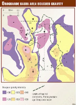
Other geophysical data, like the Bouguer gravity map provided (Fig. 2), show how the Basin and Range imposed its image on the pre-existing geology; the gravity highs (indicated by the plus) seen on this figure are associated with uplifted fault blocks or intrusive bodies. More detailed gravity and magnetic analysis must be done to reveal the subtle nature of the basement.
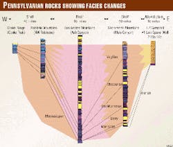
Published stratigraphic sections (i.e., from the Sacramento, Hueco, and the San Andres mountains) show the stratigraphic section that was deposited during the Pennsylvanian. These data, along with select well data, were used to construct the cross-section (Fig. 3).
Academic studies made available to the author reveal the presence of Cisco-aged bioherms in the San Andres Mountains that range in thickness from 500-1,000 ft. Detailed laboratory studies of these rocks have identified vugular and interstitial porosity in the 16-25% range. These reefs can be traced into the subsurface and occur again on the eastern side of the basin in the Sacramento Mountains.
Assembling prospects
When there is a coincidence of subsurface geological data, geophysics, and test well information, it can be used to assemble a prospect with relatively low risk. The author offers two prospects that illustrate this point.
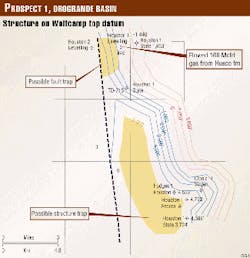
Consider one of a series of subsurface maps for Prospect Area 1 (Fig. 4). In this example, structural mapping of the top of Wolfcampian (Lower Permian) datum reveals two different areas for future tests by drilling. The first location would be an updip fault trap in which porous Wolfcampian limestones are trapped against impermeable Lower Cretaceous siltstones and shales. A well down dip from the proposed location tested the Wolfcampian (Hueco) and had a sustained flow of 168 Mcfd of gas, 91% methane. Drilling in an updip location may reveal a significant reservoir in an area that is at least 5,000 acres in size.
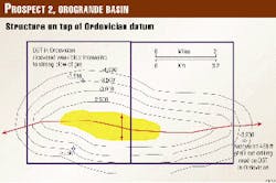
Structural mapping completed for the author's Prospect 2 reveals a significant deep structure that covers at least 4,000 acres (Fig. 5). The picture presented here, which is mapped on the Top of Ordovician datum, shows an anticlinal structure with 500 ft of structural closure.
One of the wells previously drilled in the area encountered a strong flow of natural gas, while a second well recovered 450 ft of oil-cut drilling mud on a DST. Both of these shows suggest that hydrocarbons should be found up dip in the structure.
The payoff
These are examples of the types of prospects that can be developed by integrating the existing data with newly-collected data.
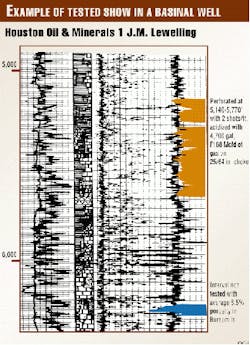
The possibility also exists of missed zones within the previously-drilled wells that could justify re-entry or offset drilling. Fig. 6 provides an example of this situation.
An interval from a well mentioned in Prospect 1 (Fig. 4) is highlighted in orange on Fig. 6. This is the interval that flowed 168 Mcfd of gas on a DST. The log analysis suggests that the interval was a fractured limestone and shale with minimal natural porosity. A second interval in this well, highlighted in blue on Fig. 6, was never tested yet shows an average porosity of 8.5% in a sandy limestone interval.
What is not known is the resistivity response in these intervals; the log available to the author was blurred during reproduction and is not easy to interpret. Detailed petrophysical review of the available well logs might reveal additional re-entry or offset opportunities.
In summary, the success of the Heyco well suggests that hydrocarbons are still present in the Orogrande basin. Based on the somewhat limited data, there are most probably additional prospects available for development. Wells in the depth range of 5,000-10,000 ft could easily test the potential reservoirs over the accessible portion of the basin.
Given the geologic similarity to both the Delaware and the Midland basins, the Orogrande basin offers an inviting opportunity. In fact, Knox2 in his appraisal of the potential of New Mexico as an oil province rated south-central New Mexico as having better potential than the Pecos Valley, which at that time hosted the initial discovery wells of the Delaware basin of southeastern New Mexico. Further, enterprising independent companies might be better equipped to develop this basin because it will require economic vision, geological and geophysical interpretation skills, and the ability to assume the risks necessary to take on a basin in this early stage of exploration.
For further encouragement, the Orogrande basin is not dissimilar to the now-productive intermontane basins of Nevada. Perhaps one or several Trap Spring or Eagle Springs-type fields lie in wait for discovery.
References
- Pyron, Arthur J., and Gray, John H., "Don't ignore the Orogrande; its potential is promising," World Oil, Vol. 5, 1985, pp. 59-67.
- Knox, John K., "Geology of New Mexico: An index to probable oil resources," AAPG Bull., Vol. 4, No. 1, 1920, pp. 95-112.
The Author
Arthur J. Pyron is sole proprietor of Pyron Consulting. He has 20 years of professional experience in oil and gas exploration and appraisals, minerals investigations, environmental studies, and site remediation. He has an MS degree in geology from the University of Texas at El Paso.
