Joint use of gravity, seismic data advances Precaspian salt modeling, depth imaging
Significant progress in depth imaging of complex hydrocarbon basins has been achieved in the 1990s. In particular, it is remarkable for the study of salt dome structures. The progress was possible, first of all, due to the use of 3D multichannel data acquisition technologies and prestack depth migration (PreSDM).
The performance of PreSDM, provided seismic data are acquired with advanced 3D technology, mainly depends on the validity of the velocity-depth model applied for migration. In complex media, the building of a valid model is a particular task that requires deep knowledge of the basin's features. Subject to the initial model accuracy, each model requires several adjustment iterations with the PreSDM technique. It determines the high cost of complex structures depth imaging procedure.
In salt-dome basins a major problem in building the velocity-depth model is correct delineation of the salt roof. The reason is that usually salt has a very complex surface that dramatically complicates imaging of both presalt and postsalt events. Experience of the Precaspian basin study indicates that salt can have such an unpredictable shape that the correct velocity-depth modeling becomes possible due to the interpreter's deep knowledge of the basin's features and also to his certain resourcefulness.
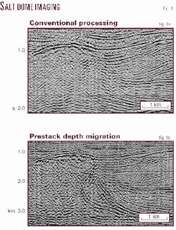
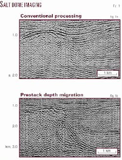
Building of the velocity-depth model is the most crucial stage of PreSDM, because an ill-defined initial salt model may either direct the PreSDM process in the wrong way or require too much time and money to repair the model. Fig. 1 represents reprocessing results of old seismic data acquired in the eastern margin of the Precaspian basin. It is clearly visible how different are the results of the regular processing and its interpretation from the real structure properly imaged by PreSDM. In this case, modeling was based on seismic data only, and it took many iterations to determine the correct model.
Note that the presalt roof in this case is relatively shallow. This reason makes a provision for the use of the presalt roof events focusing quality as an effective criterion of correct salt roof definition within a salt dome. When presalt occurs at the depths of 6 km or more, seismic is normally oriented at postsalt targets. Shorter offsets that are usually used for shallow target delineation cannot provide satisfactory focusing of deep presalt events. It means that the stated criterion would not be efficient.
That is why in internal basins with deep presalt the complementary independent data for salt are particularly valuable for correct salt structure imaging. Geological mapping and borehole data are normally used to serve this purpose. However, the recognized limitations do not allow for their wide use. Another valuable source of information on salt deposits is gravity data. This article presents how gravity data can improve seismic data capabilities for salt dome modeling and depth imaging in the Precaspian basin.
Seismic, gravity features
The Precaspian basin is the world's deepest sedimentary depression. The thickness of sediments in its center exceeds 22 km (72,000 ft).
A salt formation varies from layers to domes with the height of 4-5 km (13,000-17,000 ft) and greater in the center of the basin. The major exploration projects are focused on the pre-margin and margin parts of the basin where presalt structures-basic exploration targets-occur at depths of less than 5 km (17,000 ft). Within this area, salt domes do not exceed 2-3 km (6,000-10,000 ft) in height and are characterized by a wide variety of shapes.
Lately, the industry has been addressing postsalt targets in pre-margin parts of the basin where presalt occurs at 7 km and deeper. In these kinds of areas, salt domes can be even more complicated: from traditional dome shape to mushroom-forms, arches, or more intricate shapes.
The Precaspian basin's salt sediments are characterized by rather stable P-wave velocities in the range of 4,500-4,600 m/sec. Velocities in postsalt overburden vary between 2,000-2,500 m/sec near earth surface and 4,000 m/sec and more in the bottom of deep troughs. The high velocity contrast and complex salt dome roof make it a strong refracting and scattering boundary. That is why even state-of-the-art seismic data acquisition and processing technologies sometimes cannot provide satisfactory imaging of steep dip salt flanks and sub-dome and sub-overhang structures.
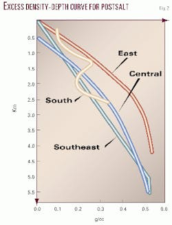
Salt bearing deposits are characterized by stable density (2.15-2.20 g/cc). Postsalt deposits are mainly terrigenous and have increasing densities from 2.10-2.20 g/cc near surface to 2.50-2.70 g/cc in the presalt. Generalization of tens of thousands of core density measurements from many wells provided density curves for postsalt in all parts of the Precaspian basin (Fig. 2).
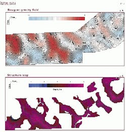
Densities of presalt deposits all over the basin vary in the range of 2.50-2.70 g/cc. Thus, everywhere in the basin, density of salt deposits is 0.1-0.5 g/cc smaller than that of the host sediments. Huge amplitudes of salt domes, steep dip salt flanks, and abnormally low density of salt cause intensive minimums in Bouguer gravity field that may exceed several tens of mGal. Fig. 3a illustrates a typical Bouguer gravity field (regional background being removed) within the block in the southeastern part of the Precaspian basin that has been chosen for the case study.
The geological nature of gravity field minimums is identified unequivocally, but practical salt body modeling based on gravity data is often a complicated task. Postsalt deposit compression increasing with depth does not allow one to directly apply the inverse gravity problem solution for constant density contrast. Moreover, the complex shape and irregular location of domes cause unacceptable modeling errors when a non-3D technique is used.
Salt modeling: method and performance
It is well known that the inverse gravity problem is ambiguous, e.g., the same gravity field corresponds to a great number of equivalent density models. The task's ambiguity is essentially reduced when a priori information on density boundaries is available.
It is very important to form the initial density model as close to the real geological media as possible. The a priori information, except for the well data, is normally represented by 2D/3D poststack time migrated sections/slices and structural (depth) maps based on them.
Normally, seismic data allow for reliable identification of a salt surface within salt dome tops only. Steep dip salt flanks, especially when complicated with overhangs, are seldom acceptably imaged on poststack time-migrated sections/slices. Since the method requires an uninterruptible input model, within these kinds of zones a salt roof is assumed to be defined by the edges of postsalt events in places of their conjectural adjoining to a salt flank.
Another basic surface-the salt bottom-is usually satisfactorily determined by seismic everywhere excluding zones beneath steep dip salt flanks where its required localizing is provided by interpolation.
The described advantages of both gravity and seismic data in the Precaspian basin provide the basis for the introduced salt modeling system, conditionally named Joint Gravity Seismic Modeling (JGSM). Performance of the system's method is attested by corresponding displays taken from the case study of one of the hydrocarbon prospective areas in the south of the central part of the Precaspian basin.
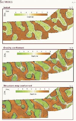
Based on existing seismic data the structure map salt roof is built (Fig. 3b). It is typically fragmentary and is delineated within salt tops only. The same data provide definition of the salt bottom at about 6.5 km depth. The target structures are located in postsalt.
The modeling process is divided into two basic stages. The first stage is devoted to the uninterruptible initial salt model forming. The modeling is implemented by a correlation forecast technique with the following essence. The Bouguer anomaly field is considered as a sum of two components: the low frequency background and the informative component that fully depends on the salt surface.
For that matter the background is defined as a polynomial (up to fifth degree) relative to coordinates, the coefficients of which are calculated using bona fide seismic data. Maximum correlation between salt depths and the informative component samples serves the criterion of coefficient set acceptability.
The uninterrupted salt surface is built using a linear forecast equation that defines the relationship between salt surface depths and informative component. The best correspondence with the real salt structure is usually achieved when the task is solved for salt domes and between-dome troughs separately. Fig. 4a shows the initial salt model that rather roughly corresponds to the structure map.
The second stage is aimed at accurate salt modeling that covers all major salt dome features of the region. The processing sequence of the second stage consists of four procedures:
- The gravity field computation for the initial salt model.
- Computation of the difference between the Bouguer anomaly and the computed gravity field.
- Spatial frequency filtering of the difference field.
- Correction of the salt model.
The gravity field is computed for volumetric bodies taking into account density variation with depth. Proper computing aperture provides involvement of all data that may contribute to the gravity field in each particular point. Procedures 2 and 3 represent computation of the uncompensated anomalies map that provides index for the controlled salt model improvement. The right correcting trend should minimize the uncompensated anomalies during iterative application of all four procedures.
The experience and evolution of the salt modeling technology testifies that unambiguous solution of the declared task can be successfully provided by multiphase upgrading organization of the modeling process. The developed method presumes three upgrade phases of salt modeling.
The first upgrade phase uses the initial salt model at input. For this phase, only the seismic data which do not contradict the gravity data, e.g., do not generate intensive uncompensated anomalies, are included in the model. Normally salt roof depths within salt dome tops only represent these data. Salt modeling of this phase is mainly based on gravity data. Therefore the output model is called a gravity salt model (Fig. 4b). Minor uncompensated anomalies that this model produces are caused by errors in model densities.
The second upgrade phase introduces salt depths taken from the salt structure map into gravity salt model. This procedure generates certain uncompensated anomalies. Some of them caused by errors of seismic data interpretation (such as inter-seismic-line interpolation errors) are removable with the modeling technique. Others cannot be suppressed without conflict with reliable seismic data.
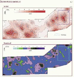
The second upgrade phase provides two products: next version of the salt model (Fig. 4c) that is fully conformed to salt structure map, and the map of steady uncompensated anomalies (Fig. 5a). Note that within salt dome crests, the conformed model almost fully repeats the structure map (compare Figs. 3a and 4c).
Interpretation of uncompensated anomalies is the objective of the third and final upgrade stage. A wide experience of gravity data interpretation in the Precaspian basin testifies that uncompensated anomalies, which cannot be suppressed without conflicting with seismic data, contain valuable information. It is authentically known that steady uncompensated anomalies, localized within the top of salt dome and adjoined with postsalt, are usually caused by salt overhangs or, to be more accurate, by under-overhang postsalt deposits.
The third upgrade phase handles all target uncompensated anomalies and finalizes the salt modeling process. The primary under-overhang model is based on the difference between the gravity and the conformed salt models. Optimization of the salt overhang model is implemented using the same above-mentioned processing sequence. The process runs iteratively until the steady uncompensated anomalies are minimized (compensated) to some lowest possible residual noise-residual uncompensated anomalies (Fig. 5b). The residual uncompensated anomaly map defines the modeling noise originated by local density heterogeneities, lateral and vertical density gradients, and other unknown or unconsidered features.
Thus the full salt model is built; it is conformed to both seismic and gravity data to the greatest possible degree. The full salt model is represented with three depth maps on the salt surface, the under-overhang rock mass's surface, and its bottom.
There are some other geological reasons for steady uncompensated anomalies (such as young troughs, grabens, etc.). However, these cases are beyond the scope of this article.
The built model supports other applications and technologies that are devoted to the Precaspian basin features studies.
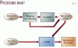
This article emphasizes the value of the modeling for the advanced depth imaging using prestack seismic data. The article considers the JGSM system as a part of PreSDM processing technology (Fig. 6).
Advanced depth imaging
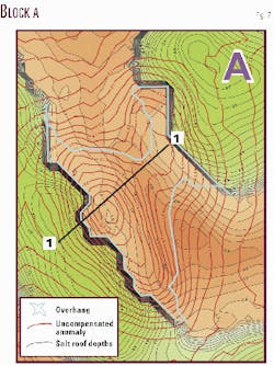
Consider block A of the modeled area in detail (Fig. 7). A seismic survey targeted at postsalt structure study within the block has been carried out. For better delineation of shallow events a sophisticated technology has been used that provided 6.25 m CMP spacing, 60 fold, and 4,200 m maximum offset.
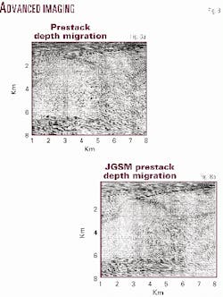
Fig. 8a represents the section's fragment along the Line 1-1 processed using PreSDM. The image obtained and the velocity analysis data suggested to pick out a dome-type structure with crest between points 2-7 at the depths of 0.6-1.4 km. The PreSDM velocity analysis, due to uncertain migration velocity spectra, did not determine any material lateral velocity deviation within the dome-type structure.
Also several strong but short events backgrounded by weak and irregular events are revealed within the body. The conclusion was made based on these data that the dome type structure represents a salt dome complicated by insalt terrigenous intercalations.
The results of JGSM salt modeling raised certain doubts in such interpretation. The modeling (its first two upgrade stages) resulted in an intensive uncompensated anomaly within the dome in question (Fig. 5a).
The third modeling upgrade stage provided identification of the under-arch rock mass with density essentially higher than that of the salt. The separation of the mass and corresponding revision of the salt dome model allowed a satisfactory compensation of the anomaly.
The derived salt model is used for seismic data reprocessing with PreSDM. The major modification of the migration velocity model caused by this salt model took place in an under-salt "beak" area where layer velocity was decreased to 4,000 m/sec, versus 4,500 m/sec in the previous model.
The new image (Fig. 8b) being in general rather similar to the previous one brings in some new valuable information. At the range of 2.6-3.2 km depths, points 6-8, clearly visible events appeared that were concealed by overmigrated events in Fig. 6. In association with the modeling results these events have been identified as the bottom of the salt arch.
Despite the fact that reprocessing didn't essentially improve the image in the range of 2.0-6.5 km, a certain regulation of events has taken place. A similar observation is valid for the steep dip horizon and adjacent zones within the depths of 1.6-3.3 km, points 1-3.
Note the deep events that occur at 6.0-6.7 km and deeper. The reprocessing certainly enhanced their image within the points 1-7 where the model undergoes the major changes. Although this depth range does not play a practical role, the better focusing of the presalt events proves the correct trend of the overburden model modification.
All the noted changes of the image allowed a reassessment of the postsalt prospects of this zone. According to the new data, the under-arch section is composed of terrigenous Upper Permian and Triassic deposits. They are characterized by the region typical low rock property differentiation and form the so-called "turtle shell" type structure that occurs under the salt "beak." Absence of extended events in this section apparently indicates the folded structure of the under-arch section.
Thus the new data testify that besides postsalt above-dome traps a large terrigenous under-overhang (under-arch) structure has been revealed.
Conclusions
Depth migration of seismic data is a strictly target-oriented process, e.g., to correctly image the earth structure, the depth migration requires maximum knowledge of the features of the structure to be imaged.
In practice this "chicken-and-egg" loop is normally broken with seismic tools only: as a rule, with combination of post- and prestack migration techniques. However, these tools may not be successful in complex media.
The presented joint seismic and gravity data-based modeling method allows for advancing depth migration processing in the right direction via reducing the velocity-depth ambiguity in complex media and advance seismic data imaging performance.
Acknowledgments
The authors thank First International Oil Corp. for the opportunity to use its data in the article. The authors appreciate M. Korostyshevsky, depth migration group leader, Geotex, and K. Zalensky, project manager, Ministry of Natural Resources, Kazakhstan, for their valuable contribution to the data preparation.
The authors
Kairat Z. Sydykov is a consultant to energy services and oil companies in Almaty, Kazakhstan. From 1995-2000 he was president of Geotex JSC, the largest geophysical contractor of Central Asia, in general management, development of marketing strategies, and other duties. Before that he served in gravity and seismic data acquisition and processing organizations. He graduated from Kazakh Polytechnic University and holds a PhD degree from Moscow Gubkin University of Oil and Gas. E-mail: [email protected]
Alexander V. Matussevich is a leading researcher of the Specialized Gravimetry Enterprise of the Ministry of Natural Resources. His current duty is joint interpretation of gravity and seismic data acquired by local and international oil companies in Kazakhstan. He has more than 30 years of experience with exploration and R&D in the Precaspian basin. He graduated from Kazakh Mining and Metallurgy Institute and holds a PhD degree from Moscow Gubkin University of Oil and Gas.
Bazar A. Eskozha is an exploration manager with First International Oil Corp., Almaty, Kazakhstan. His responsibilities include design of exploration projects and reservoir modeling. In 35 years he has also worked for different exploration, production and research organizations of West Kazakhstan including AtyrauMunayGazGeologia, EmbaMunayGaz, and KazakhstanCaspiyShelf. He graduated from Moscow Gubkin University of Oil and Gas and holds a PhD degree from Moscow State University.
