Tanzania's Mafia deepwater basin indicates potential on new seismic data
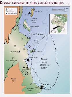
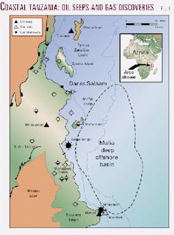
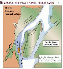
The Mafia Deep Offshore basin (MDOB) of southern Tanzania is one of several East African basins that resulted from the break-up of the Gondwana continent from the Middle Jurassic onwards (Figs. 1, 2).
The basin occupies an area of some 75,000 sq km developed between the Tanzanian continental shelf edge and the Davie Fracture Zone 200 km east of the coast. The water depth ranges from approximately 500 m to a maximum of 3,300 m in the southeast of the basin.
The availability of a modern Western Geophysical high resolution seismic survey has allowed interpretation of the basin's geological development in far greater detail than previously. Prior to this study the basin's geology had been interpreted only from very widely spaced reconnaissance seismic data of the 1976 Sea Gap Group proprietary survey and the Lamont-Doherty East Africa Margin study.1
The MDOB offers some of the few remaining frontier exploration opportunities in Africa. It is situated adjacent to the petroliferous Tanzanian coastal basin, where there are known onshore oil seeps and subsurface gas discoveries.
The extrapolation of well data from this coastal area in combination with the stratigraphic and structural interpretation of the MDOB has facilitated the definition of its petroleum potential. Multiplay potential is recognized, and the possibility exists for several world-class hydrocarbon discoveries comparable with those recently made in West Africa.
The area is to be offered for licensing by the Tanzanian authorities in September 2000.
Regional setting, structure
The MDOB has developed along a transform plate margin formed after the break-up of Gondwanaland during Bajocian times.
The transform element, now represented by the Davie Fracture Zone, acted as a zone of dextral displacement of the Madagascar block with respect to Africa, probably until the Neocomian. This is consistent with a relict spreading center located some 200 km east of Mafia Island that is identified from magnetic anomalies dated at 110-120 MaBP.
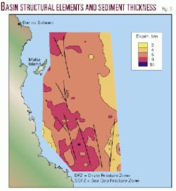
For the greater part, however, the basin is floored by Karroo-aged rocks with the total post-Karroo sedimentary thickness estimated from seismic profiles to be up to 10 km thick (Fig. 3). Oceanic crust is only present beneath the post break-up sedimentary cover in the extreme eastern parts of the basin, beyond the area of the new seismic survey.
The basin's present-day structure is dominated by prominent north-south lineations that correspond to the Sea Gap and Davie Fracture Zones, both dextral strike-slip fault complexes (Fig. 3). Locally there is an associated series of NNW-striking faults related to both extensional and compressional regimes caused by Neogene inversion movements along the fracture zones.
Both inversion-related anticlines and faulted closures are associated with the major fault lineations and provide a number of potential traps for hydrocarbons.
Stratigraphy
The subsurface geology of coastal Tanzania is known from a limited number of exploration wells and several deep stratigraphic boreholes.
The post-Karroo, entirely marine, sedimentary section is characterized by unconformity-bounded megasequences with major unconformities recognized at Base Pliocene, Base Miocene, Base Middle Eocene, Base Paleocene, Base Upper Cretaceous, and Base Middle Jurassic (Break-Up Unconformity).
Below the Break-Up Unconformity are younger (Jurassic rift system) and older Karroo sediments of restricted marine and continental facies, respectively.
No wells have been drilled in the MDOB, but using vintage shallow-water seismic data and coastal zone well control it has been possible to tie directly down to Base Upper Cretaceous unconformity level on the new Western Geophysical survey.
Deep Sea Drilling Project sites 241 and 242 provide additional control for the deepwater area. These data points are, however, located off Kenya and Mozambique 400 and 500 km from the MDOB survey area, respectively.
Only Site 241 is tied by multichannel seismic data and calibrates with certainty the Base Miocene reflector. The bottomhole formation is dated as Late Senonian (Upper Cretaceous), but the hole does not penetrate to the next deepest significant reflector.2 Site 242 proves sediments possibly as old as Turonian.
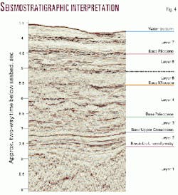
For the deepwater area a seismostratigraphic scheme has been established in which seven major layers are recognized.
By analogy with the coastal basin the layers have been interpreted to be unconformity-bounded megasequences reflecting the response of the Tanzanian margin to episodic continental doming and rifting and oceanic spreading events. The seismic characteristics of the defined layers, with preliminary stratigraphic assignments, are (Fig. 4):
Layer 1-Karroo (or Basement): a general lack of coherent reflections interpreted as Older Karroo or Pre-Cambrian terrain. In places high-angle dipping reflectors are seen which are interpreted as preserved remnants of Younger Karroo section.
Layer 2-Middle Jurassic to Lower Cretaceous: essentially parallel, sub-horizontal, high frequency, continuous reflectors showing an onlap relationship to the top of Layer 1. The sequence is separated from Layer 3 by a significant high amplitude reflector.
Layer 3-Upper Cretaceous: similar in character to Layer 2, displaying an overall higher frequency, but with less amplitude contrast.
Layer 4-Paleogene: a zone of high frequency reflectors that exhibits a stacked, mounded geometry displaying internal clinoforms and external onlaps. These features are interpreted as successive channel cut and fill sequences and associated erosional remnants.
This layer can be subdivided into several sequences, each characterized by a prominent zone of high frequency, very high amplitude reflectors at their bases.
Layer 5-Lower Miocene: displays a deeply erosive unconformable base with associated high amplitude reflectors. The upper part of the layer shows generally very high frequency, parallel, continuous reflections with a reduced amplitude character.
Layer 6-Middle and Upper Miocene: displays very high frequency, generally continuous reflection character. Strong amplitude packets indicative of channel geometries occur throughout the layer. The base of the layer is unconformable towards the shelf.
Layer 7-Pliocene to Recent: similar to Layer 6, but with less continuous character. It also shows an unconformable base in parts.
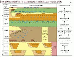
Combining data from the coastal basin wells with the seismostratigraphic interpretation of the Western Geophysical data it is possible to establish a composite chronostratigraphic and seismostratigraphic scheme for the Tanzania deep offshore area to act as a framework for the assessment of the petroleum potential of the area (Fig. 5).
Coastal basin hydrocarbons
The Tanzanian coastal basin is a known petroliferous area.
Hydrocarbons occur at the surface on Pemba Island and the Tanzania mainland, and shows of oil and accumulations of gas have been proved in several offshore and coastal island wells (Fig. 2). These occurrences display varying geochemical characteristics pointing to the existence of several active petroleum systems in the area.
Surface occurrences
The Tundaua oil seep on Pemba Island shows isotopic characteristics of derivation from a marine source and a good biomarker correlation with extracts from Campanian shales in the Kimbiji East-1 well.
Oil is also known from seismic shot holes on Mafia Island.
At Wingayongo in the Rufiji basin, 160 km inland from the coast, there is an oil seep associated with bitumen-stained Lower Cretaceous sandstones. It appears that this represents a breached and exhumed paleo-reservoir. The seep displays isotopic and biomarker characteristics indicative of a restricted, carbonate lacustrine source.
Several oil seeps are known on Msimbati Island in the Ruvuma basin. Two at least show characteristics of true degraded crude oils derived from mixed sources.
One component indicates derivation from strongly reducing carbonate environments and another indicates a contribution from Upper Cretaceous or younger sources. There is also a gas seep on the island, but this is believed to be of biogenic origin.
Subsurface occurrences
Songo Songo gas field contains petrogenic gas and associated liquids in a Lower Cretaceous sandstone reservoir. The gas is unusually dry (97% methane) and the associated condensate has a restricted boiling range. This liquid is the isotopically heaviest hydrocarbon discovered in the area.
There is, however, no proven correlation of the condensate with any candidate source rocks.
The Mnazi Bay gas discovery is of biogenic origin. It is reservoired in Oligocene deltaic sandstones and was likely derived from organic matter in the same formation.
Oil and gas shows were reported from Paleogene formations in the Mafia-1 and Pemba-5 wells and gas shows from Ras Machuisi-1, Tan Can-1, and Zanzibar-1. All the shows are confined to Paleogene horizons.
Source rocks, maturation
Four potential source formations for oil are recognized in the coastal basin: Middle Eocene shales, Upper Cretaceous (Maastrichtian to Campanian) shales, Middle Jurassic shales, and Lower Jurassic (Younger Karroo) shales.
In addition, Lower Cretaceous shales and Older Karroo shales and coals are potential sources for gas.
Eocene and Cretaceous sources are Type II to Type III kerogens with TOC contents up to 12.1% and 7.4%, respectively (corresponding HI values up to 396 and 688).
Middle and Lower Jurassic sediments show Type I to Type II characteristics (TOC up to 8.7%, HI up to 1,000).
Older Karroo formations appear to be dominantly Type II to III. Each of these sources is likely to be present in the MDOB.
The Eocene and Upper Cretaceous open marine shales are thought to be developed throughout the basin within Layers 3 and 5, respectively. Lower and Middle Jurassic shales are probably more restricted in distribution, occurring in pre or post- break-up isolated half-grabens.
Recorded geothermal gradients in coastal basin wells vary from 18° to 51° C./km.2 The higher values of the range are thought anomalous due to the significant tectonic inversion of the area associated with local 'hot-spots' under Mafia and Pemba Islands.
Away from these areas more 'normal' passive margin-type geothermal regimes are expected to be developed basinwards to the east. Confirmation of this situation is given by the measured geothermal gradient of 27° C./km recorded at DSDP Site 242.3
In view of the extensive inversion of the coastal area it is difficult to assess true maturity-depth relationships in the well sections. However, it should be noted that in the least uplifted well (Tan Can-1) the oil window is recorded between depths of 3,000 m and 3,900 m based on vitrinite reflectance data.
Given the likely depth of burial of potential sources in the MDOB the Middle Eocene is expected to be mature for early to peak oil in the deepest parts of the basin at present-day.
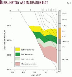
The Upper Cretaceous is expected to be mature for hydrocarbons throughout the area, mostly for oil with some gas generation in the deeper tracts. Jurassic and older formations are mostly in the gas window or spent. Preliminary burial history and maturation modeling of the MDOB confirms that Maastrichtian/Campanian-aged potential source formations have been hydrocarbon generative since the early Miocene through to the present day (Fig. 6).
Reservoirs
The Songo Songo and Mnazi Bay gas discoveries indicate the effectiveness of Lower Cretaceous and Oligocene shallow marine and deltaic sandstones as reservoir formations. In addition, Paleogene oil and gas shows in the coastal zone wells point to potential reservoirs in Layer 4 in the MDOB. Although not hydrocarbon-bearing, outer shelf facies turbidite sandstones of Paleogene and Upper Cretaceous ages with porosities of up to 28% have been observed in some wells.
In the MDOB primary reservoir targets are anticipated to be Miocene to Paleocene (and perhaps Upper Cretaceous) slope and basin facies channel-fill sediments and turbidites.
Channel-fills at these stratigraphic levels are likely to be sand-prone, having been fed from large volumes of deltaic sand sourced from the Rufiji and Ruvuma paleo-river systems. It should be noted that similar facies of Miocene age are prolific reservoirs in West Africa.
The Paleogene and Neogene section is interpreted to comprise several basin-fill megasequences showing shifting depocenters with time.
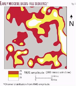
The distribution of sand-prone channels within the sequences can be determined directly from the seismic data by a study of amplitude variations at the target horizons. Illustrated here, for part of the area, is the channel distribution within the basal layer of the Lower Miocene sequence based on RMS amplitude (Fig. 7); note the general west-east orientation consistent with a down-slope sediment transport.
Other potential reservoirs include the deeper offshore equivalents of Lower Cretaceous shallow marine sandstones, Middle Jurassic limestones, and sandstones of Karroo formations.
The likely depth of burial of these older formations probably precludes their effectiveness as reservoirs, except where their porosity has been preserved or otherwise enhanced; for example, in zones of uplift associated with fracture zones.
Seals
The sedimentary sequence in the MDOB is interpreted, in common with other passive margin basins, to be dominantly shale- and mudstone-prone. For the principal reservoir targets sufficient thicknesses of sealing formations are therefore expected to be present.
Trapping styles
The basin displays a variety of trapping styles:
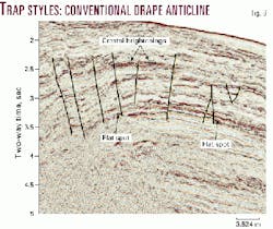
- Conventional drape anticlines (Fig. 8).
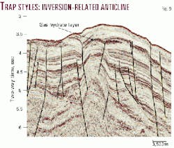
- Inversion-related anticlines (Fig. 9).
- Fault-bounded traps in inversion structures.
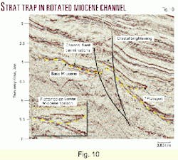
- Stratigraphic traps in channel-fill sediments (Fig. 10).
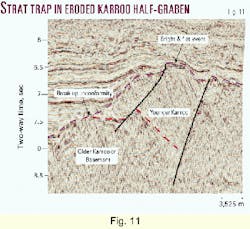
- Truncation traps in eroded half-grabens (Fig. 11).
- Stratigraphic pinch-out at basin margin.
It is important to note the close association of many of the structures with relatively late-stage faulting which can provide effective conduits for migrating hydrocarbons.
Direct Hydrocarbon Indicators
Particularly encouraging for the petroleum potential of the MDOB and the effectiveness of the identified trap styles is the occurrence of a number of direct hydrocarbon indicators (DHIs).
Flat-spots are associated with several structures throughout the basin. The example illustrated here (Fig. 8) shows a well-defined horizontal reflector on the flanks of a faulted drape anticline. A fluid contact is the most-likely explanation for this feature.
The highlighted area on Fig. 9 shows a prominent strong reflector paralleling the seabed which truncates bright inclined reflectors over the crest of an inversion-related structure. This is interpreted to be a gas hydrate layer trapping migrated gas below.
The central part of the structure also shows significant disruption related to gas effects.
At shallow levels throughout the basin there are numerous occurrences of bright spots and amplitude enhancement. Some are associated with deep faults indicating the likelihood of petrogenic gas being derived from mature source rocks at depth.
Licensing opportunities
The Tanzania Ministry of Energy and Minerals through Tanzania Petroleum Development Corp. intends to offer the MDOB for licensing in September 2000.
The license round will be open for six months with awards being made on the basis of competitive bidding. Licenses will be based on a PSA-type contract with favorable fiscal terms and without signature bonuses.
The government of Tanzania is reviewing its model PSA in the light of the additional risks associated with the deepwater environment.
The payoff
A reconnaissance geological and geophysical study of the MDOB has established multiplay petroleum potential. Of particular importance are:
- Sedimentary geometries and seismic patterns indicative of reservoir development.
- Candidate source formations occurring at depths suitable for oil and gas generation.
- Seismic identification of structural and stratigraphic trapping styles.
- Presence of late-stage inversion-related faults acting as migration conduits.
- Recognition of DHIs indicative of active petroleum systems.
This favorable set of criteria should attract the interest of international oil companies to the basin for hydrocarbon exploration when the area becomes available for licensing.
References
- Coffin, M.R., and Rabinowitz, P.D., "Evolution of the conjugate East African- Madagascan margins and the western Somali basin," Geological Society of America Special Paper 226, 1988.
- Fjaeran, T., Abrahamsen, K., and Ntomola, S.J., "Source rocks and hydrocarbon distribution in the coastal basin, Tanzania," in "Oil and Gas Exploration in the SADCC Region," pub. SADCC Energy Technical and Administrative Unit, 1987, pp. M1-M18.
- Marshall, B.V., and Erickson, A.J., "Heat flow and thermal conductivity measurements, Leg 25, Deep Sea Drilling Project," Initial Reports of the Deep Sea Drilling Project 25, 1974, pp. 349-55.
The author
Michael Cope is senior exploration geologist in the exploration and reservoir services division of Western Geophysical, a division of Baker Hughes Inc. Based in London, he has previously held senior exploration positions with the Petrofina Group and with Texaco Ltd. working on West Africa, North Africa, Central Asia, and the Northwest European Shelf. Cope also has geological survey experience and holds BSc and PhD degrees in geology from the University of London. He is a visiting research fellow at Oxford Brookes University, UK, pursuing interests in African petroleum systems. E-mail: [email protected]
