SW Siberia's Jurassic, Bazhenov may contain much larger oil reserves
The name "Bolshoi Salym" is applied to a group of areas and oil fields located in Shirotnoye Priob'e between the Ob' and Irtysh Rivers. They include Salym, North Salym, West Salym, Prirazlomnoye, Verkhne-Shapshinskoye, Sredne-Shapshinskoye, etc. The Mesozoic-Cenozoic sedimentary rocks overlying Pre-Jurassic with angular and nondepositional unconformity play an important role in the geology of these areas and fields.
The basement (seismic horizon A) is composed of Middle Devonian quartz-porphyry, and the weathered basement is composed of porphyry, gravelstone, and tuffaceous mudstone. In some locations between basement and Jurassic there is an intermediate sequence composed of Permo-Triassic effusive-sedimentary rocks.
The Lower and Middle Jurassic sequences are composed of continental deposits belonging to the Tyumenskaya formation, and the Upper Jurassic is composed of marine deposits belonging to the Abalakskaya and Bazhenov formations. The Tyumenskaya formation (reflection horizon T) is composed of thin-interbedded sandstone, siltstone, and mudstone with rare intercalations of coal and argillaceous limestone. The Abalakskaya formation is dominantly composed of shale with subordinate siltstone intercalations. The Bazhenov formation is composed of siliceous-argillaceous-carbonate rocks rich in organic matter. The formation is also known as reservoir J0 to which seismic horizon B is assigned.
The Jurassic is overlain by terrigenous Cretaceous and Cenozoic rocks.
Oil inflows obtained in some areas in 1967-69 presumably from the Bazhenov formation stimulated exploration drilling mainly aimed at this formation. Wildcat-exploration drilling for Jurassic rocks underlying the Bazhenov formation was not so extensive. Nevertheless, a considerable amount of seismic and well data have been collected by now.
It should be noted that there is a large difference between the 2D and 3D field seismic techniques which hampered separate and integrated interpretation of 2D and 3D data and subsequent summarizing. Special software packages were used to exclude or at least minimize the negative effects of this difference.
The following data have been obtained in the wells penetrating the Jurassic section of various thickness: stratigraphy of the bottom-hole zone, lost circulation zones, oil, gas, and water shows, core analysis, test intervals and results, physical and chemical oil characteristics, methods of well completion and flow inducing, etc. The analysis and summarizing of all available data whose main results are presented in this article throw a new light on hydrocarbon prospectivity of the entire Jurassic sequence and the Bazhenov formation in particular.
Re-evaluating the Jurassic
The results of reprocessing and interpretation of more than 2,000 km of 2D data and more than 1,000 sq km of 3D data in combination with the data of more than 200 deep wells enable us to make the following conclusions.
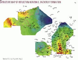
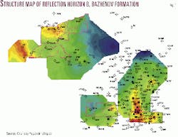
- On the whole, the present-day structural configuration of the top of the Bazhenov formation (Jurassic) does not differ from the configuration obtained earlier by other workers. But due to the application of the latest software, methods of processing and interpretation of seismic data, and incorporation of the latest well data, the present-day structural configuration is more detailed (Fig. 1).
- From the structural viewpoint, the area of interest is characterized by two well-defined uplifts in the northwestern (Priobskoye) and southeastern (Salym) parts and a deep trough between them. This trough is especially deep on the north-northeast. A chain of structures bounding the trough can be traced between the two uplifts from northwest to southeast. It suggests a positive tectonic element (isthmus?) connecting the Priobskoye and Salym uplifts. This assumption is based on the structural conformity between the tops of the Bazhenov and Tyumenskaya formations and the base of the Jurassic inferred from seismic data.
- The structural configuration of some horizons (beds) within the overlying Lower Cretaceous is less distinct. It is attributed to the fact that the Neocomian is represented by a clinoform sequence whose structural configuration differs considerably from those of overlying and underlying rocks.
- In the interpretation of seismic data we attached paramount importance to the identification and tracing of faults within the Jurassic. It is established that faults are extensive both vertically and laterally. Fault tracing over the area indicates that the dominant fault trends are NE-SW and NW-SE; faults trending N-S and E-W are rare. Probably the faults that trend NW-SE are "younger" than the NE-SW faults because the structural elements associated with them have a similar trend and are superimposed on the dominant NE-SW structural trend of the area.
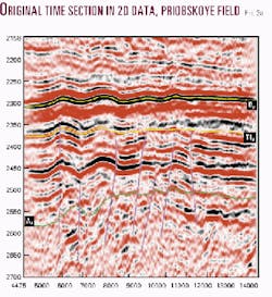
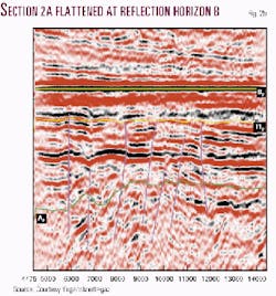
- Fault tracing in the vertical direction showed that they originate from Pre-Jurassic. Their planes are almost vertical; most faults die out within the top of the Tyumen formation (Figs. 2a, b). Above the Tyumen formation the configuration of reflection horizons did not enable us to identify faults unambiguously. In rare cases the faults are tentatively traced to the top of Bazhenov by a sharp change in the configuration of the Bazhenov top, which takes the form of a flexure, and also by the presence of faults unambiguously identified within the underlying rocks.
This information concerning fault tectonics refutes the opinion of some workers, in particular Yermakov et al.,1 who asserted (1995): "... at present there is no measured data confirming the presence of major faults in the sedimentary cover of the region."
We can assume that fault tectonics resulted in greater permeability of the Jurassic and Pre-Jurassic rocks not only due to faulting but also due to formation of subvertical fractures. The faults and fractures in turn were the main paths of hydrocarbon migration from lower to upper deposits.
Identifying fractures
We attached special importance to the analysis and generalization of all data obtained in drilling of numerous wells.
The core analysis data show that the rock matrix is practically impermeable to fluid. Its filtration properties depend on the presence of open fractures. That is why identification of open fractures over the area and the section is very important for estimation of reservoir properties of the Jurassic rocks. The latest methods developed at Central Geophysical Expedition were used for this purpose.2
The analysis of drilling data, in particular lost circulation and oil, gas, and water shows, provided important information concerning the type of reservoirs, intervals where the borehole crosses open fractures, and reservoir pressures. This simple and quick method was widely used during drilling through the Jurassic rocks in Bolshoi Salym where oil and gas shows and lost circulation were reported in many exploration wells.
Out of 160 wells where drilling data were analyzed, oil and gas shows or lost circulation (or both) were reported in 124 wells (77.5%); all these drilling problems were observed in various series of Jurassic. Lost circulation and oil and gas shows during drilling are a reliable indicator of fractured reservoirs. The above data concerning lost circulation and oil and gas shows suggest an extensive development of fracturing within the Jurassic.
Comparing pressures
We also used another method to identify fractured reservoirs. It is based on the comparison of horizontal rock pressure with formation pressure.
If formation pressure Pform exceeds horizontal rock pressure Prock , i.e., the condition Pform > Prock is met, then open vertical fractures exist in the section. The condition Pform < Prock suggests the absence of open vertical fractures.
We estimated the horizontal rock pressure by three independent methods: on the basis of Poisson's ratio, by controlling the tangential stress on the borehole wall, and by hydrofrac data. In all cases the magnitude of Prock was below normal hydrostatic pressure for the same depth. This implies that the condition for the existence of open vertical fractures is met even when formation pressure is equal to the normal hydrostatic pressure.
In the area of interest formation pressures within Jurassic measured with downhole pressure gauges during well tests in many wells are abnormally high. It ensures that the condition Pform > Prock under which open vertical fractures can exist in a large depth range and over a large area with high pressure is met.
The upper boundary of the open fracturing zone is found by data on lost circulation and oil and gas shows during drilling through the Bazhenov formation. In most wells this boundary is more than 10 m below the top of the Bazhenov formation. The fractures extend down to the depth where the condition for their existence (Pform > Prock) ceases to be met. In the Jurassic rocks of Bolshoi Salym open fractures go through the entire Jurassic interval into the basement. Open fracturing also predetermines the dominance of fractured reservoirs within the Jurassic.
Identifying producing intervals
Hydrocarbon prospectivity of the Jurassic is associated with the Tyumenskaya and Bazhenov formations. Judging by numerous publications, the Bazhenov formation is the main oil-producing horizon; it is believed that it is this interval that has been producing oil for a long time in some fields.
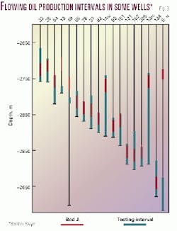
According to the analysis of test data, in most cases the overlying and underlying zones were also tested in combination with the Bazhenov formation (Fig. 3). Out of 350 tested intervals the Bazhenov formation alone accounts for only 9%, in combination with the overlying and underlying zones it accounts for 63%, and the underlying interval accounts for 20%.
Well logs to identify production intervals were not run in the exploration wells. That is why production intervals were exclusively assigned to the Bazhenov formation without good reason.
It should also be taken into consideration that in the flow tests of intergranular reservoirs whose thickness is always limited the production intervals are usually directly associated with the perforation intervals. In such cases oil samples really characterize oil properties of the test zone. In the tests of fractured reservoirs the production intervals correspond to the intervals where the borehole crosses open vertical fractures by which formation fluid flows from the zones located at a different depth. Thus, the results of flow tests do not characterize the "Bazhenov" oil ("oil from the J0 horizon," "oil from the Bazhenov formation") and do not suggest an oil reservoir within the Bazhenov formation. Instead the results show the presence of oil within the Jurassic in a large depth range and over a large area.
Water, salt in Jurassic
In the analysis of various sources of information one can notice scarcity of data on water content of the Jurassic interval of Bolshoi Salym. Production of pure oil in most wells led to the conclusion that there is no oil-water contact. A comprehensive examination of this problem enabled us to find a number of wells which produce oil with water, for example, wells Salym-17, 34, 112, Verkhny Salym-13, etc.
Salt content is also a characteristic feature of oils like the content of asphaltene, resins, paraffin, etc.; therefore it must also be analyzed. According to the analyses of 51 oil samples from 45 wells, most samples can be characterized by the following parameters: salt content from "not found"-"trace" to 2.11-31.88 mg/l. In some samples salt content is considerably higher: well 12: 290.25 mg/l, well 34: 58.12 mg/l (the first sample), 791.6 mg/l (the second sample); well 51: 63.6 mg/l. It should be noted that oil with water was tested in wells 34 and 51. In well 12 a mud blowout with subsequent oil blowout occurred during drilling through the horizon underlying the Bazhenov formation. The abnormally high salt content in the oil of this well must be regarded as an omen of near water entry into the well from deeper deposits.
It should be noted that some workers point out a high salt content in oil samples. For example, in Nesterov et al.3 the authors write: "A sharp change of salt content in oils must be noted. There is no salt in most oils, but in some oils the salt content reaches 30-40 mg/l. In the Lempinskaya-34 well salt content is as high as 792 mg/l at abnormally high water cut (to 8.63%) with other characteristics to be within the average values." The authors cponfined themselves to the statement that salt content in some wells was high. But as it follows from the oil analysis data, there is an obvious correlation between a higher salt content and water cut. The presence of water in oil suggests a good fluid communication between the oil and water zones of the reservoir, i.e., presence of an oil-water contact. It is quite naturally taking into account the large length of open vertical fractures. The possible position of the oil-water contact was inferred from the results of tests run in more than 200 exploration wells. The available data suggest that Jurassic pay zone thickness amounts to several hundred meters.
The shut-in bottom-hole pressures measured during tests of the Jurassic interval are abnormally high. The maximum pressures are reported in well 121 and 123 of the Sredne-Shapshinskaya area and the Salym-101 well. The excess pressure factor Pexc (relation of actual well pressure to normal hydrostatic pressure at the same depth) in these wells exceeds 1.7. A considerable difference of some physical properties of shales that occur above the Bazhenov formation and under it should be noted. For example, a qualitative comparison of apparent resistivity Ra for shale of the Achimovskaya formation (above the Bazhenov formation) and shale of the Abalakskaya formation (below the Bazhenov formation) shows that Ra of the Achimovskaya shale exceeds Ra of the Abalakskaya shale at least twice. Such difference in resistivity of shale formations suggests difference in their porosity which is produced by abnormally high pore-fluid pressure of the shale of the Abalakskaya formation.
High formation pressure area
We used the difference in shale resistivity between the Achimovskaya and Abalakskaya formations to estimate the area of the abnormally high formation pressure (AHFP) zone within the Jurassic. According to the available data, the size of the AHFP zone (within a rectangle) is at least 130 km x 120 km (15,600 sq km). Taking into account some data given in Yermakov1 and Nesterov,3 the size of the AHFP zone is greater than 250 km x 150 km (37,500 sq km).
The geographical boundaries of the AHFP zone are as follows: western, along the Irtysh River valley to the river's confluence with the Ob' River and farther probably along the Ob' River valley; northern, north of the Ai-Pim area; southern, south of the Verkhne-Salym area; and eastern, east of Pravdinskoye field.
The vertical extent of the AHFP zone was estimated on the basis of worldwide experience gained in overpressured hydrocarbon fields. The publications that treat the high pressure problem4 5 6 7 give numerous examples showing that high pressures are normally observed over hundreds (sometimes thousands) of meters down the section. It should be noted that these publications do not give a single example when a well after entering the AHFP zone and going through it reached a zone of normal pressures.
The vertical distribution of high pressures in Bolshoi Salym obeys the general regularity of AHFP behavior established all over the world. This statement is confirmed by concrete facts:
- Gas and oil shows during drilling through various Jurassic intervals at mud weight above 1 g/cc.
- Wide development of open vertical fracturing ensuring fluid communication between zones located hundreds of meters from each other.
- Inflow of formation fluid from the lower interval of the Tyumenskaya formation and upper interval of the basement.
- Direct pressure measurements in flow tests of the base of the Tyumenskaya formation and the top of the basement (Pexc > 1.4).
- Calculation of pore-fluid pressures in shale immediately overlying the basement (Pexc > 1.51).
Seismic pressure studies
Seismic data were also used to estimate the distribution of high pressures in the Jurassic in addition to the above parameters. We used interval velocities for this purpose. This method is based on the following principle: the greater pore-fluid pressure in a rock, the less velocity of elastic waves in it. Seismic data processing with a special program (written by Z. Lozinsky) showed that interval velocities within the AHFP zone in Jurassic are considerably less than the interval velocities typical of normally pressured formations. The difference is 5-19% of normal velocities; in about 90% of the area the difference is at least 15% of normal velocities.
Thus, the established AHFP zone within the Jurassic has an area of 15,600 sq km (the area of the presumed zone is more than 37,500 sq km) and its depth interval is more than 400 m. No well yet drilled in Bolshoi Salym has reached the lower boundary of the AHFP zone.
Fig. 3 is a scheme of tests of some zones characterized by flowing production and abnormally high formation pressure. It illustrates the depth range of oil saturation and AHFP zone within the Jurassic.
What is the barrier preventing the expansion of high pressures from the Jurassic to the Cretaceous? In Bolshoi Salym the boundary between the zones of normal and high pressures coincides with the boundary between the Jurassic and the Cretaceous rocks. The boundary is associated with the Bazhenov formation separating the zone of normal pressures in the Cretaceous from the AHFP zone in the Jurassic. The siliceous-argillaceous-carbonate rocks of the Bazhenov ideally meet the criteria which, according to the well-known expert K. Anikeev,4 characterize the formation which serves as "the lithologic barrier" in the overpressured fields.
Areas for further exploration
To identify the most prospective areas for further exploration and justify well locations we attempted to correlate productivity of exploration wells with their structural position and also well productivity with individual seismic parameters.
For this purpose we analyzed data of flow tests of the Jurassic interval made in almost 100 exploration wells located in the area of 2D and 3D seismic surveys or in their vicinity. The well location was also analyzed with respect to the crest of structure, flank, trough, and slope of the trough. The limits of the identified structural elements are tentative except the crest and the trough, because there are no definite criteria for their justification. That is why a line is drawn arbitrarily between the crest and the trough, the area adjoining the crest is regarded as the flank, and the area adjoining the trough is regarded as the slope of the trough.
Producing wells and dry wells are located on all identified structural elements. The wells whose oil production rate exceeds 100 cu m/day are normally located on the crests and flanks of structures, the wells with production rate from 20 to 80 cu m/day are located on the troughs and trough slopes. The wells with production rate at most 20 cu m/day are almost uniformly distributed between all structural elements, whereas dry wells are normally assigned to the troughs and their slopes. We should not ignore the fact that many wells were considered dry because of wrong drilling, flow inducing, or completion technologies.
Thus, the analysis of test data and the well structural position suggests that oil presence in the Jurassic does not depend on structural position; a well can be productive only when it penetrates the zone of open fracturing. These data also show extensive open fracturing (and faulting) within the Jurassic.
The method to correlate well productivity with seismic parameters and the results obtained are treated comprehensively in Gogonenkov.8 Here we only mention that the attempt to establish relationships between well productivity and some seismic parameters has not provided unambiguous results. We realized that only a combination of several seismic parameters into an integral parameter according to a certain rule can provide good results.
Estimating oil reserves
In light of the above it is interesting to estimate oil reserves on the basis of the following considerations. Let us assume that the productive pay area controlled by the AHFP zone is equal to this zone, i.e., 15,600 sq km, and that the net pay is equal to the vertical extent of fractures, i.e., 350 m. Let the fracture volume be 0.3% (f = 0.003). At oil density of 0.8 t/cu m and oil formation factor 1.4 (parameters typical of Jurassic oils) the oil reserves calculated by the volumetric method are in excess of 9 billion tons.We want to emphasize that these are recoverable reserves, because we calculate only the amount of oil contained in the fractures; if proper oil production technology is used, all oil will be recovered. In this connection we want to say that the depletion drive pilot production of Jurassic reservoirs has already yielded almost 300,000 tons in some wells.
It should be also noted that in this reserve calculation we used minimum parameters deliberately. But there are good reasons to assume greater productive pay area, net pay, and fracture porosity. With account of such changes the volume of the oil-filled fractures will increase at least 2-3 times and oil reserves will amount to 20-30 billion tons.
Therefore, the Jurassic sequence of Bolshoi Salym and the adjacent areas is composed of rocks broken by subvertical faults and fractures whose length exceeds hundreds of meters. Open fractures form a single hydrodynamic system and serve as the main reservoir of overpressured oil. The zone of commercial oil reserves is controlled by the AHFP zone whose area amounts to several tens of thousand square kilometers. The Bazhenov formation serves as a "lithologic barrier" that separates the normal pressure zone within the Cretaceous from the AHFP zone within the Jurassic.
Giant recoverable oil reserves contained in the fractures suggest that the Jurassic reservoir is a primary oil accumulation which has no analog all over the world. Therefore, we believe that Russia has the largest hydrocarbon reserves in the world.
Acknowledgment
The authors thank Yuganskneftegaz for the permission to use geological and geophysical data in this article.
References
- Yermakov, V.I., Kirsanov, A.N., and Kirsanov, N.N., et al., "Geologicheskie mode* zalezhei neftegazokondensatnykh mestorozhdenii Tyumenskayaskogo severa" ("Geological models of reservoirs of oil-gas-condensate fields of the northern part of the Tyumenskaya Region"), Nedra, 1995, Moscow (in Russian).
- Limberger, Y.A., and Il'inskii, V.M., "Vydelenie i izuchenie treshchinnykh kollektorov v razrezakh skvazhin" ("Identification and study of fractured reservoirs in borehole sections"), Geofizika No. 1, 1998, pp. 74-77.
- Nesterov, I.I., Ushatinskii, I.N., and Malykhin, A.Ya., et al., "Neftegazonosnost' glinistykh porod Zapadnoi Sibiri" ("Presence of oil in argillaceous rocks of West Siberia"), Nedra, 1987, Moscow (in Russian).
- Anikeev, K.A., "Prognoz sverkhvysokikh plastovykh davlenii I sovershenstvovanie glubokogo bureniya na neft I gaz" ("Prediction of abnormally high formation pressures and improvement of deep drilling for oil and gas"), Nedra, 1971, Leningrad (in Russian).
- Dobrynin, V.M., and Serebryakov, V.A., "Metody prognozirovaniya anomal'no vysokikh plastovykh davlenii" ("Methods of prediction of abnormally high formation pressures"), Nedra, 1978, Moscow (in Russian).
- Melik-Pashaev, V.S., Khalimov, E.M., and Seregina, V.N., "Anomal'no vysokie plastovye davleniya na neftyanykh I gazovykh mestorozhdeniyakh" ("Abnormally high formation pressures in oil and gas fields"), Nedra, 1983, Moscow (in Russian).
- Fertl, W.H., "Anomal'nye plastovye davleniya" ("Anomalous formation pressures"), Nedra, 1980, Moscow (in Russian)
- Gogonenkov, G.N., Grinshpun, A.V., and Bachin, S.I., "Prediction from 3D seismic data of productive zones within the Jurassic Bazhenov and underlying section in the Salym area of West Siberia," EAGE, Helsinki, Finland, June 7-11, 1999.
The Authors
Yuri Limberger is chief geophysicist of a research group at Central Geophysical Expedition (CGE), where he has worked since 1967. He is involved in formation evaluation and rock studies by well logs and hydrodynamic and core data. He is a graduate of Moscow Oil Institute (Gubkin) qualified as a mining geophysical engineer and received a PhD degree in geology and mineralogy from the same institute. E-mail: [email protected]
Alexander V. Grinshpun is a department chief at CGE, which he joined in 1967. He is involved in 2D and 3D seismic data interpretation and geological modeling of oil reservoirs and fields. He is a graduate of Moscow Oil Institute (Gubkin) qualified as a mining geophysical engineer.
Alexander S. Lavrik is chief geologist of CGE, his employer since 1985. He is involved in 2D and 3D seismic data interpretation and geological modeling of oil reservoirs and fields and creation of data bases. He is a graduate of Moscow State University qualified as a geophysical engineer.
Mikhail G. Luvishis is leading geologist of the research department of CGE, which he joined in 1997. He is involved in integrated interpretation of geological-geophysical data aimed at identification of hydrocarbon prospects. He graduated from Moscow Oil Institute (Gubkin) qualified as a geological engineer. He received a PhD degree in geology and mineralogy from All-Union Research Geological Prospecting Institute.