Bolivia's sedimentary basins hold large gas, oil potential
The Republic of Bolivia is a land-locked country that comprises 1,098,582 sq km (424,163 sq miles), equal to the size of California and Texas combined.
Latest population figure is 7.4 million.
About 535,000 sq km of Bolivia is considered to have hydrocarbon potential. Today, 124,297 sq km is operated by private companies and the other 410,703 sq km is open for bidding.
In Bolivia the evolution of the different tectonic and sedimentary cycles established the development of several superimposed basins. The events occurred between the middle Proterozoic until late Neogene.
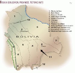
The development of the sedimentary basins has been controlled by the following geotectonic units (Fig. 1):
- Guapore or Brazilian Shield
- Arequipa Massif
- Madidi high
- Izozog high
- Michicola high.
The geology and stratigraphy of Bolivia are briefly summarized here.
In the South America-African sector of the Gondwana continent, the Precambrian was made up of central shields that were reworked in a succession of fracturing and welding that resulted in the upper Precambrian Pan African and Brazilian deformation cycles. The central shield areas are surrounded by a pericratonic stable platform which is later invaded by Paleozoic seas.
The distribution and geometry of the Paleozoic basins are closed related to the structural Brazilian cycle events. In Cambrian times, except the Puncoviscana formation occurring in the present Argentine territory, the marine sediments correspond to platform environments.
Since Ordovician to Middle Jurassic times, most of Bolivia consisted of a large sedimentary basin that was subjected to a Middle Ordovician compressional episode and was controlled by large-scale transtensional to transpressional conditions from the late Ordovician to Triassic.
After the mid-Triassic rifting failure, Bolivia was stable until the late Jurassic.1
In late Cretaceous time began the Andes uplift. In the late Oligocene, Andean thrust deformation began in the west and extended eastwards through Neogene time. Main igneous activities occurred in Mesozoic and Mio-Pliocene to Recent times.
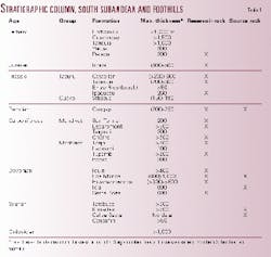
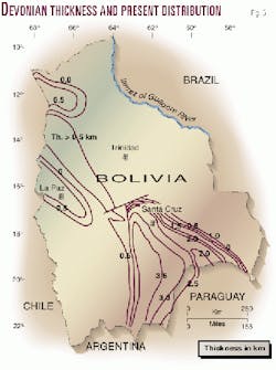
Below the Subandean, the basement is at least at 12 km deep. Cambrian to Carboniferous sediments are clastic. Thicknesses are reported to reach over 1,000 m in the Ordovician, 1,350 m in the Silurian, 2,950 m in the Devonian, and 2,900 m in the Carboniferous-Permian. These thicknesses mainly correspond to Southern Subandean (Table 1).
The marine carbonates in Bolivia are of Permian and Cretaceous age, present at the Subandean and at the Bolivian Altiplano, respectively, and the Permian/ Triassic Vitiacua formation in the Subandean. In addition, Vendian carbonates are also found in the Chiquitanas province.
On the basis of common geological events and similar physiographic features that characterize the different regions of the country, the following geological provinces were established (Fig. 1):
- Madre de Dios
- Chaco-Beni-Chiquitanas
- Guapore Shield
- Subandean and Foothills
- Eastern Cordillera
- Altiplano
- Western Cordillera
- Pantanal.
The foothills unit or province was postulated by O. Lopez Paulsen.2 The Andean foothills are located between the Subandean and the Chaco-Plains. In the north, no Andean foothills are present, and the Subandean is separated from the plains through faults. The foothills also extend into Argentina.
In this article, the Chaco and Beni basins are reviewed together. Commercial production is obtained in the South Subandean, Foothills, and Chaco basins.
Petroleum geology
Bolivia's main wealth is in gas.
As of Oct. 31,1999, Bolivia's proved remaining reserves were estimated in 300.28 million bbl of oil and condensate and 13.05 tcf of gas. Probable reserves are a further 234.38 million bbl of oil and condensate and 10.64 tcf of gas.
Oil production during 1999 was 11,847,901 bbl from about 330 wells and 176.7 bcf of gas. During 1999, companies acquired 204.83 km of 2D seismic data and 330 sq km of 3D seismic and drilled 33 wildcats. Of these, 14 established hydrocarbon production, 15 were under completion, and four were abandoned.3
The Subandean was first explored in 1916 and 1920, and in 1924 Standard Oil discovered liquid hydrocarbons at Bermejo near the Argentine border. After 1950 new exploration occurred outside the Subandean, which led to the discovery of the Madrejones (1959) and Caranda (1960) fields. Since then, exploration and drilling has been concentrated in the foothills, where the Bolivia's main hydrocarbon reserves have been discovered.
The areas total 333,040 sq km or 57% of the prospective basin acreage. Drilling density for the three basins is about three wells per 1,000 sq km.
Average depth to objectives: North Subandean 3,760 m; South Subandean 4,060 m; Boomerang-Chapare 3,600-4,700 m; and Plains 2,700 m.
Exploration potential
In Bolivia, only three basins have production: Subandean, Foothills, and Chaco. The Altiplano and Madre de Dios basins have some exploration interest.
Subandean
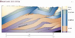
The Subandean is characterized by outcropping folded Paleozoics east of the Eastern Cordillera. The intensity of deformation decreases towards the Brazilian shield. Traps are narrow (1-3 km) and long (10 km) asymmetric anticlines. The east flank normally is steeper and often faulted. Thrust faults dipping west are most common. Detachment levels are Devonian and Silurian, although some will be deeper. The basement is not involved. Some 200 anticlinal structures have been recognized, and about 60% were tested. The trap of the Margaritas discovery is described by Ayaviri et al.4 as a four-way closure anticline 20 km long and 4 km wide. Detachment levels occur in shales of the Silurian Kirusillas formation (Fig. 2).
Source and reservoir rocks
The sedimentary section consists of clastics and minor carbonates (Table 1). The Devonian Los Monos shales are the main source beds for oil and gas in the area. TOC values have up to 2%, Type II-III mixed marine-terrestrial kerogen.
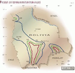
The Ro values range between 0.5% and 1.2% (Fig. 3).
The Los Monos unit is thickest and shalier and more oil prone into the foreland basin. Due to the complex maturity picture, it is possible that the Los Monos source beds followed different maturation paths in different parts of the basin (Fig. 3).
Pre-Devonian sediments are important as potential gas-source rocks. Dunn et al.5 reported that the Silurian source rocks are overmature in the belt and still within the gas window in the foreland.
In addition, E. Aguilera6 reported that shale intercalations from the Vitiacua formation in localities near Tarija city had TOC values between 1% and 1.4%, soluble organic matter values between 960-1,000 ppm, and C15 of 120-200 ppm. It was also determined to be a Type III kerogen (woody). The generation capacity must be confirmed with pyrolysis and vitrinite reflectance analysis (Ro).
The dark shales of the Upper Miocene Yecua are a possible source rock.
Reservoirs are Devonian sandstones of the Iquiri and Huamampampa (porosities between 8-14%) formations and clastics of Carboniferous, Triassic, and Cretaceous age. Deeper reservoirs are the Devonian Santa Rosa sandstones, productive in Ramos and Aguarague fields (Argentina).
Depths to objectives vary between 530 and more than 4,022 m.
Concentrated in this basin are 28% of the country's liquid reserves and 12% of the gas.
Monteagudo, Cambeiti, and Tatarenda fields are examples of this basin. At present, the major Margarita discovery is a new and encouraging example of the Subandean (Fig. 2).
The North Subandean has no production. Devonian, Carboniferous, and Permian source rocks with TOC values ranging from 0.5-3.4% were reported. Reservoir sandstone levels of Devonian age have porosities that range from 9-16%, and the Carboniferous sandstone reservoirs have porosity values between 14-21%.
The belt is oriented NW-SE, and the thrusts are wider than in the south.
Foothills
In the Foothills the intensity of deformation is less than in the Subandean, with simple folds and thrusting of moderate structural relief. The oil was generated in Devonian source rocks (TOC values of 0.5-1% and Ro values between 0.5-1.4%, Fig. 3) while the Silurian shales are potential gas source rocks. Hydrocarbons are accumulated in Silurian, Devonian (8-12% porosities), Carboniferous (average 11% porosity), and Triassic, Cretaceous, and Tertiary reservoirs at depths ranging between 1,460-5,200 m.
Madrejones (1959) was the first oil field discovered in the foothills.
In its central part, the fold and thrust belt forms a bend characterized by a transfer zone known as the Santa Cruz boomerang, which was elevated at the end of the Carboniferous in response to the Hercynian orogeny and remained elevated until the late Cretaceous. Most striking features are gentle folds which are controlled by the basement geometry and the shape of the sedimentary wedge.7
Several liquids and gas fields are located in this zone, which here is included in the foothills.
In the foothills are concentrated 70% of the liquids and 86% of the gas reserves.
Chaco basin
The Chaco basin is characterized by gentle topographic relief. The limits are the foothills to the west and the Brazilian craton to the east. The NW-SE Izozog arch, uplifted in Tertiary-Cretaceous time, is located between these units and separating the Chaco into a western and eastern sub-basins, the latter known as the Robore or Curupayti (in Paraguay) depocenter (Fig. 3).
The sediments thin over the arch and were subjected to Cretaceous erosion. The arch plunges NW where the Tita-Techi fields are located. To the eastern margin, seismic lines showed a Precambrian-Cambrian extensional basin. The Outuquis well confirmed the existence of 4,000 m of Precambrian, Cambrian, Silurian, Devonian, Carboniferous, and Cretaceous sediments. Total organic carbon values of 0.14% to 4% were reported from Precambrian shales, 1% from shales of the Silurian El Carmen formation, and 0.50% from shales of the Devonian Limoncito formation. In addition, oil and gas seeps in limestones of the Corumba/Murcielago formations on the Bolivian/Brazil border have been reported.8 It is possible that in deeper parts of the basin, the source rocks are sufficiently mature and hence, hydrocarbon possibilities may exist (Fig. 3).
This rift basin marks a continuation of the Santa Cruz transfer zone, borders the craton northeast of the Chaco basin, and controls the distribution of the Silurian and Devonian beds.
Along the Chiquitanas trend and not influenced by the Andean deformation, subtle anticlinal structures are associated with early Paleozoic half-graben.
In the western part of the basin as well as in the Robore depocenter, although containing proven sediments of Silurian to Tertiary age, the sequence is dominated by Silurian, Devonian, and Carboniferous sediments due to a period of strong basin subsidence and pre-Andean orogeny.
In the rest of the Chaco basin, trapping mechanisms are low structural relief folds, shear faulting, and stratigraphic and combination traps.
The oil generated by the Los Monos shales (Ro values range from 0.5-1.4% at top Devonian shale and 2-3% at base Devonian shale9 10) was reservoired in Devonian units and, as in Tita field, in Carboniferous channel sands, carved in Devonian units (Fig. 3). This channel system exists along the Chaco basin and is also found in the Northern Paraguay, Curupayti, and Carandayti subbasins11 and the Tarija basin in Argentina.12 The Carboniferous has porosity values between 11-15%, while the Devonian reservoirs have porosities from 8-12%.
The Chaco accounts for 2% of the liquids and 2% of the country's gas reserves. Tita field was the first discovery in the Chaco basin.
The objectives are found at depths ranging between 2,330-3,460 m.
Altiplano
The Altiplano is located between the Western and Eastern Cordillera and extends to the north into Peru (Lake Titicaca) and to the south into Argentine territory (Cretaceous basin). The basin covers 140,000 sq km, 100,000 sq km of which is in Peru.
The Altiplano basin was formed by extension in late Mesozoic and deformed by compression during Tertiary.
In Bolivia some 1,500 m of Cretaceous and up to 5,000 m of Tertiary sediments are present. Cretaceous sediments are partly marine; Tertiary sediments are of continental facies. The underlying Paleozoic sediments include Ordovician, Silurian, and Devonian units. Several oil seeps occur. Source beds are reported from three Cretaceous intervals. Geochemical analysis of Paleozoic source beds indicated that they are overmature.13 Locally high geothermal gradients are probably due to Neogene magmatism.
The best reservoirs are fine sandstones of Tertiary age and Upper Cretaceous sandstones with porosities between 2.6 and 26% and permeabilities up to 466 md. Secondary objectives are the Upper Cretaceous El Molino fractured limestones (the productive Yacoraite limestones in Argentina), and Paleozoic sediments may be locally prospective.
Tilted normal faulted blocks and compressional deformation with west-verging thrust and reverse faults formed major structural traps.
During the 70s, dry wells were drilled by YPFB (2), Superior (2), and Sun (1). From 1990-95, Exxon/Marathon drilled the Toledo X1 well and YPFB drilled the Colchani X1 and the Santa Lucía X1 wells in the southern and western portions of the basin.
These wells do not condemn the basin as they failed to test Cretaceous potential reservoirs and prospects. Interest is maintained by Caimancito field and the Valle Morado discovery in northwest Argentina, on trend with the Bolivian Altiplano. Caimancito produces from Late Cretaceous-Paleocene fractured limestones reservoirs of the Yacoraite formation (El Molino carbonates in Bolivia) which accumulated 10.087 million cu m (63.6 million bbl) of oil. As of December 1998, proved recoverable reserves in the Valle Morado structure amount to 1,033,200 bbl of oil (164,000 cu m) and 72 bcf of gas (2,043,990,000 cu m). Probable recoverable reserves were estimated at 2,778,300 bbl of oil (441,000 cu m) and 194.8 bcf of gas (5,516,000,000 cu m)
Madre de Dios basin
The Madre de Dios basin extends northward into Peru. It occupies 120,000 sq km, and more than 50% of the basin lies in Bolivian territory.
It is bounded on the east by an area of Paleozoic through Tertiary onlap onto the Brazilian shield and to the southwest by the Subandean fold belt and to the south by the Maididi high (Fig. 1). In Peru it is separated from the Ucaya* basin by the Fitzcarrald arch.
The stratigraphy consists of a Precambrian basement overlain by Middle Ordovician to Late Silurian fluvio-deltaic units capped by a thin, shallow marine carbonate.14 They are followed by Devonian shales and sandstones, Carboniferous clastics, Permian limestones and minor shales, Cretaceous sandstones and shales, and Tertiary red beds. The sequence is up to 9 km thick.
Most of the wells drilled in the basin had oil shows. In addition, the Pando X1 well recovered crude oil in thin sandstone intervals. Peters et al.14 postulated that the total generative capacity of the upper Devonian source rock within the basin is 250-1,000 billion bbl of oil equivalent. However, the same authors indicated that the block was relinquished, mainly due to the lack of structural traps. The basin has a high risk exploration potential.
Conclusions
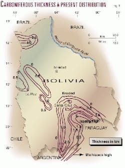
The South Subandean, Foothills, and Chaco basins have the best exploration potential for gas and oil. The Devonian and Carboniferous are the main reservoirs in Bolivia (Figs. 5, 6).
Several discoveries confirm the occurrence of the Huamampampa formation north of the San Alberto range. They are Caranda (1.2 bcf of recoverable reserves), Palmar X14 (2 bcf), San Alberto (1.2 bcf) (Fig. 4), Sabalo (2 bcf) and Maragarita X3 with initial production rates of 67 MMcfd of gas and 900 b/d of 49.9° gravity condensate.
Huamampampa is productive in several fields in Argentina and thus opens new exploration opportunities in the zone between the Argentine border and 20° S. Lat. Towards Santa Cruz the reservoir conditions of the Huamampampa formation are poorer.
The Los Monos formation is the source rock in the basin. The best generation capacity is located between 63-64° W. Long. and 22-20° S. Lat.
It is necessary to remark that almost all the basins have source rocks with generation capacity (mainly Devonian and due to local conditions also the Silurian shales), good sandstone levels with good reservoir characteristics, seal rocks, and traps. However, in-depth studies on generation and migration of the hydrocarbons are necessary in all the areas.
It is possible that the anticlines are charged with hydrocarbons generated from the synclines located adjacent and to the west of the traps.
Once development of the fields is completed, the reserves will be sufficient to commit with the exports to Brazil. In addition, the gas line to Brazil increases the interest in exploration for gas mainly in deeper reservoirs (Devonian Huamam- pampa, Santa Rosa sandstones and equiv.) and in areas adjacent to the pipeline.
It was announced that a 36-in. gas pipeline parallel to the Bolivia-Brazil pipeline will be constructed within Argentine territory and will supply gas to Formosa, Chaco, Corrientes, and Misiones provinces. Hence, more Bolivian gas will be needed and will raise the exploration interest in the Northwest and Chaco-Parana basins of Argentina.
Acknowledgments
Special thanks to Dr. E. Palamarzuk for scanning the figures and Drs. Jose Arandia and Gustavo Sangines with YPFB at Buenos Aires for providing statistics and suggestions.
References
- Sempere, T., "Phanerozoic evolution of Bolivia and adjacent regions," in Tankard, A.J., Suarez, R., and Welsink, H., eds., "Petroleum basins of South America," AAPG Memoir 62, 1995, pp. 207-230.
- Lopez Paulsen, O., "El límite interno del plegamiento andino en Bolivia y su relación con los campos productores de la Llanura Chaco-Beniana," III Simposio Bolivariano, Exploración de las Cuencas Subandinas, 1988, pp. 476-503.
- YPFB, Vicepresidencia de Negociaciones y Contratos, Informe de Actividades, Exploracion-Explotacion de Hidrocarburos y Exportacion Gas Natural, Div. Estadística, Santa Cruz, 2000.
- Ayaviri, A., Fernandez, C., and Toribio, E., "Margarita: un yacimiento gigante de gas en las Sierras Subandinas de Bolivia," Bol. Inf. Petroleras (YPF), Buenos Aires, Vol. 60, 1999, pp. 46-53.
- Dunn, J., Hartshorn, K., and Hartshorn, P., "Structural styles and hydrocarbon potential of the Sub-Andean thrust belt of southern Bolivia," in Tankard, A. J., Suarez, R., Welsink, H., eds., "Petroleum Basins of South America," AAPG Memoir 62, 1995, pp. 523-543.
- Aguilera, E., "Petrografía, mineralogía de arcillas y geoquímica de la formación Vitiacua en la parte norte y Sud de Tarija," Rev. Técnica de YPFB XI, Vols. 2-3, 1990, pp. 197-204.
- Welsink, H. J., Franco., A., and Oviedo, C., "Andean and Pre-Andean deformation, Boomerang Hills, Bolivia," in Tankard, A.J., Suarez, R., and Welsink, H., eds., "Petroleum basins of South America," AAPG Memoir 62, 1995, pp. 481-499.
- Franca, A.B., Milani, E.J., Schneider, R.L., Lopez P., O., Lopez M. J., Suarez S., R., Santana, H., Wiens, F., Ferreiro, O., Rosello, E., Bianucci, H., Flores, R., Vistalli, M.c., Fernandez S., F., Fuenzalida, R., and Muñoz, N., "Phanerozoic correlation of South America," in Tankard, A.J., Suarez, R., and Welsink, H., eds., "Petroleum basins of South America," AAPG Memoir 62, 1995, pp. 129-161.
- Pucci, J.C., "Resumen de las cuencas sedimentarias del Paraguay y sus posibilidades petrolíferas," Dir. Nac. Combustibles, unpub. report, 1984.
- Salinas, E., Oblitas, G., and Vargas, F., "Exploración del Sistema Carbonífero en la Cuenca Oriental de Bolivia," Rev. Técnica de YPFB, VII, Vols. 1-3, La Paz, 1978, pp. 5-49.
- Pucci, J.C., "Resumen de las cuencas sedimentarias del Paraguay," Bol. Inf. Petroleras (YPF), Vol. 28, Buenos Aires, 1991, pp. 42-48.
- Pucci, J.C., "Relinquishments in Argentina will boost exploration interest," OGJ, Sept. 30, 1996, pp. 103-107.
- Livieres, R., Wischneider, W., Bacchiana, C., Dyess, J., and Guthrie, G., "Impact of Toledo x-1 on the geological understanding of the Eastern Altiplano, Bolivia," VI Simposio Bolivariano, Exploracion Petrolera en las Cuencas Subandinas, Cartagena, Memorias II, 1997, pp. 154-157.
- Peters, K.E., Wagner, J.B., Carpenter, D.G., and Conrad, K.T., "World class Devonian potential seen in eastern Madre de Dios basin (Part 1)," and "Eastern Madre de Dios Devonian generated large volumes of oil (Part 2)," OGJ, Feb. 17, 1997, pp. 61-65 and Feb. 24, 1997, pp. 84-87.
Bibliography
Giraudo, R., Limachi, R., Requena, E., and Guerra, H., "Geologia estructural de la faja fallada y plegada del Subandino Sur, Bolivia," Bol. Inf. Petroleras (YPF), Buenos Aires, Vol. 59, 1999, pp. 54-70.
Lopez Pugliessi, M., Krutsfeld, M.C., and Arias Paz, R., "Exploración petrolera en Bolivia," YPFB, Gerencia de Exploración, 1990.
Oller and Sempere, "A fluvio-eolian sequence of probable Middle Triassic-Jurassic age in both Andean and Subandean Bolivia," First International Symposium on Andean Geodynamics, Grenoble, Paris, Editions de l'Orstom, 1990, pp. 237-240.
Quevedo Velasco, J., "Esquema del origen y migración de los hidrocarburos en Bolivia," Rev. Técnica de YPFB, IV, Vol. 1, 1975, pp. 5-50.
Welsink, H.J., Martinez, E., Aranibar, O., and Jarandilla, J., "Structural inversion of a Cretaceous rift basin, southern Altiplano, Bolivia," in Tankard, A.J., Suarez, R., and Welsink, H., eds., "Petroleum basins of South America," AAPG Memoir 62, 1995, pp. 305-324.
The Author

Juan Carlos Pucci has been active in international exploration for many years. His employers included GSI, Cities Service, and Mobil. He was the geologist representing the Secretary of Energy in the privatization of Argentina's upstream sector. At present, he is a consulting geologist specializing in South America and in the organization of upstream privatization processes. He is also working on the definition of new major plays in basins of Argentina (mainly Austral, Neuquen, and Northwest), Bolivia, Brazil, Chile, Costa Rica, Ecuador, Guatemala, Paraguay, Perú, and Uruguay. He holds an MS degree in petroleum geology and a PhD degree in geology from the University of Buenos Aires. E-mail: [email protected]