Southern San Joaquin basin has underexplored 'complex westside'
For about 30 years the author has studied the geology of the San Joaquin basin, concentrating largely on the highly-productive west side.
Industry refers to this area as the "complex westside" (CW), an informal and not particularly complimentary designation. The author intends to present an optimistic overview of this mature sub-province by delineating overlooked opportunities that have been the subject of speculation among geologists studying this area but have seldom been put into print.
The author's early background of surface mapping and subsurface studies in this area was with Shell Oil Co. Later he conducted field mapping and subsurface studies as an independent and consultant.
He re-mapped an area in the Temblor Mountains, near McKittrick, in 1986 and found an incompletely tested, important structural and stratigraphic prospect on trend with major production but stratigraphically lower than any nearby production.
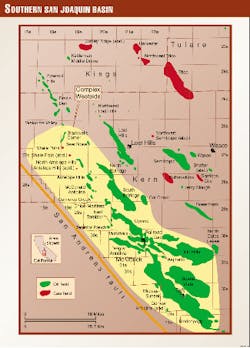
An intensive review of the adjacent geology led the author to the conclusion that not only is this prospect still attractive for older objectives but that it could be representative of similar opportunities in an expanded CW sub-province (Fig. 1) that was underexplored largely because of its location within or adjacent to a mature basin.
Additional regional studies convinced the author that there are underexplored opportunities in other measures throughout major sectors of this sub-province, and it is these aspects that are the main focus of this article.
General background
The purpose of this condensed report is to present the reasons why the author believes that a significant area for new production still exists in this sub-province of the southern San Joaquin basin.
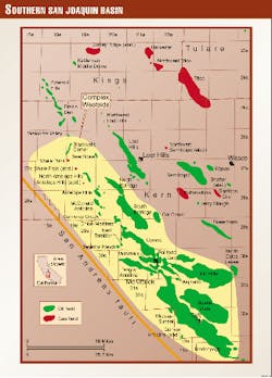
The CW area is within a strip about 60 miles long and as wide as 20 miles (Fig. 1). Within this sub-province lie oil and gas fields that have related provenance stratigraphy and are in a close-knit structural system of varying complexity.
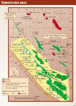
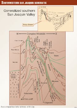
The western boundary of the sub-province as described here has been drawn within the Temblor Range rather than at the eastern edge of the Temblors and thus includes a relatively unexplored area (Fig. 2). The eastern boundary of the sub-province separates this area of moderate to severe folding and faulting from the more gently disturbed central part of the southern San Joaquin basin (Fig. 3).
The CW contains about 20 named oil and gas fields that the author estimates to have combined estimated ultimate recovery of 7.5 billion bbl of oil equivalent and that others estimate will yield as much as 10 billion bbl.
Production has been known for about 100 years from fields that range in size from small (less than 5 million boe ultimate) to giant (about 2 billion boe ultimate).
Four of these fields, Belridge, Midway-Sunset, Buena Vista, and Elk Hills, account for about 85% of the total known reserves.
Thousands of wells in this sub-province produce from numerous reservoirs in a variety of structural and stratigraphic traps; unfortunately there has not been a known major discovery in 30 years, but neither has there been definitive wildcat drilling for deeper production. Consequently, exploration has declined due to this lack of discoveries and has been further discouraged by:
- The perceived high cost per discovery for US exploration in apparent contrast to non-US exploration.
- The environmental constraints.
- The perception of tough-to-solve land acquisition problems.
- The apparent inability to define structural complexities in this area with conventional geophysics.
These concerns have been understandable, but the net result has been exploration downsizing and consequently a dearth of discoveries.
Concerns 1 and 2 might still be with us, but recent industry information indicates a greater flexibility in land opportunities and "state-of-the-art" 3D seismic imaging has now demonstrated the ability to obtain resolution formerly unobtainable.
As in some other areas, geological cliches the author believes to be supported by only sparse control have also contributed to unimaginative exploration planning. Paradoxically, however, production due to infill drilling and improved recovery techniques has remained at a high level.
For this report, it is the author's intention to discuss several of the more significant geologic aspects that are considered relevant for encouraging additional review that could lead to new exploration.
Therefore, the following paragraphs will cover those pertinent geologic aspects and interpretations that lead to the conclusions that can be summarized as follows:
- Pre-Upper Miocene measures are relatively unexplored in the southern 30% of the area (Fig. 2).
- Opportunities for structural and stratigraphic traps in measures below present production are largely unexplored along the entire eastern flank of the Temblor Range and perhaps in other parts of this sub-province (Fig. 2).
Stratigraphy
Sedimentary rocks exposed and-or penetrated in this sub-province range in age from Cretaceous to Pleistocene and overlie Franciscan basement, a subduction complex of metasediments and volcanics.
Cretaceous sediments were derived dominantly from eastern and western granitic sources and deposited as part of the Great Valley Sequence in a Jura-Cretaceous forearc basin. Eocene clastics, an end stage of this forearc basin deposition, were derived largely from a southwestern to western granitic provenance that subsequently moved about 200 miles to the northwest along the San Andreas fault.1
Oligocene to Upper Miocene clastics were similarly derived from an adjacent and mobile landmass on the west side of the San Andreas fault and additionally as a product of local erosion resulting from an episodically uplifted and crumpled ancestral Temblor Range east of the San Andreas fault (Fig. 3).
The structural effects related to movements on the San Andreas fault since inception of transform tectonics and the consequent infilling of the adjacent San Joaquin basin have continued into the Present.
Presently-producing horizons in the various fields range in age from Upper Eocene to Pleistocene and consist of sandstones, fractured siliceous shales, and diatomite. However, by an overwhelming percentage, the major production occurs in units that are Upper Miocene to Pliocene in age, and with one minor exception there is no pre-Upper Miocene production south of Belgian Anticline field (northwest end of purple outline in Fig. 2).
In this article we are considering production opportunities mainly in coarse clastics that are Middle Miocene to Lower Eocene in age as these are the measures that the author considers underexplored. Thus it is of major relevance for exploration that geologic data support the interpretation that in several geologically brief time intervals Tertiary sediments were deposited in alternating and at times coeval environments of deposition that ranged from very shallow marine to very deep water, perhaps bathyal in depth.
This alternation of environments indicative of vertical mobility specifically along the western edge of the CW has given support to the descriptive term "yo yo" tectonics. This is reinforced by:
- Outcrop evidence of angular unconformities that are not seen basinward.
- Also from outcrop studies, sedimentary features that are indicative of changing environments of deposition, e.g., juxtaposed shallow-water and deepwater criteria.
- Faunal assemblages throughout the sub-province that reflect changing bathymetry.
Utilizing these data one can visualize the Temblors during the time span of the Oligocene to Middle Miocene, when transform margin tectonics became dominant as a string of islands, a peninsula, or the eastern edge of a large landmass split by the San Andreas fault.
During this time frame, rapid transgressions across the mobile Temblors salient caused the deposition of high-energy, shallow marine sands of the Oligocene-Lower Miocene Phacoides reef (Wygal) and Agua sand and the Middle Miocene Buttonbed across cannibalized older units such as the Point of Rocks sand (Middle to Upper Eocene). Coeval units were deposited in the adjacent deeper water of the San Joaquin basin.
The paleogeography during the Eocene epoch, a time of convergent margin tectonics, is more challenging to reconstruct. The occurrence of a shallow-water, correlative, transgressive unit of early Middle Eocene age (the Mabury, Avenal, and Domengine formations) which is overlain and underlain by deeper-water sediments similarly suggests vertical mobility perhaps reflective of a prototype San Andreas fault.
None of the above comments is unique; all have been widely expressed within industry and academia. However, abrupt lateral facies changes in a very short distance resulting from shallow to deepwater deposition have not in the author's opinion been widely or adequately incorporated into exploration planning.
The correlation between units that outcrop, such as the Phacoides reef (Wygal), and time-equivalent productive measures (Belridge 64 and Main Phacoides) in nearby fields has led to a largely-accepted concept of continuity when in reality these coeval units may be physically disconnected, thus offering untested opportunities for stratigraphic traps.
Another aspect potentially more important for future exploration is the possibility that objectives of Lower Eocene to early Middle Eocene are locally present in the subsurface though not seen in the outcrops. These would be analogous to the Gatchell sand of Lower to early Middle Eocene age that is productive in the Coalinga area 50 miles to the north but is not recognized in the outcrops).
As this article is oriented towards specific units that offer exploration opportunities, the following is a listing of those measures that the author considers potentially prospective and underexplored. All these measures are shown schematically on Fig. 3.
Lodo formation
In the Diablo Range,2 a northerly continuation of the Temblors, this Paleocene-Lower Eocene unit consists of dark gray siltstones and claystones with a thick, medial sandstone.
Lower Eocene sandstones that are productive in the Kettleman Hills and the Coalinga fields are the approximate age equivalent of the Lodo formation, but these sandstone measures are questionably recognized if even present in the outcrops within the Diablo Range.
In the Temblors the Lodo formation consists of dark gray siltstones and claystones that have a typical greenish cast, and no interbedded sandstones have been identified.
In the area considered for this review (blue outline on Fig. 2), probably six wells have adequately penetrated this stratigraphic section in an area of about 224,000 acres. In consideration of this paucity of subsurface control, the possibility that there are prospective, lenticular sands in this large area can neither be denied nor reinforced, thus presenting a challenging if not formidable exploration task.
Mabury sandstone
A shallow-water unit named the Mabury sandstone that overlies the Lodo formation is poorly exposed in the northern part of the Temblors.
This early Middle Eocene unit is correlative and at one time possibly was contiguous with the shallow-water Avenal3 and Domengine4 sandstones that outcrop in the Diablo Range and with the Domengine in the subcrop.
In the Temblors at one measured locale this unit is nearly 500 ft thick and consists of fine to medium grained, buff-colored sandstones with limey, coarse-grained beds at or near the top. The coarse-grained texture and the very common fossil hash in the upper sandstones are suggestive of shore-face deposition.
Within the review area (blue outline in Fig. 2) at abandoned Shale Flat and Shale Point fields, a gas sand about 100 ft thick is in a stratigraphic position equivalent to the Mabury but appears to pinch out updip.
The author notes the puzzling distribution of the "Mabury sandstone" and its sharp boundaries as seen on the electric logs and suggests that in these wells this unit is a turbidite or an isolated channel sand coeval but not contiguous with its stratigraphic equivalent in the outcrops. Deep tests at Belgian Anticline and Elk Hills fields 25-30 miles to the southwest of these abandoned gas fields did not encounter any sands equivalent to a "Mabury."
In spite of its limited distribution, the shallow-water Mabury sandstone seen in the Temblors is considered to be a potential objective in structural traps within or in some areas adjacent to the Temblors and at depths of 3,000-8,000 ft. The possibility that there are lenticular sands of shallow or deepwater origin equivalent to the shallow-water Mabury offers opportunities for stratigraphic entrapment throughout the area.
Middle Eocene Canoas shale
This unit is also poorly exposed in the Temblors but where measured is about 800 ft thick and consists almost entirely of siltstone and claystone. A thin, platy sandstone near the center of the unit, where measured, shows typical deepwater features; a faunal sample at that locality verified the age and bathyal environment.
The Canoas shale is a lower section of the Eocene-Oligocene Kreyenhagen formation which with the Miocene Monterey formation contain the major source rocks in the San Joaquin basin. Thus sands interfingering or in juxtaposition with the Canoas shale could be in a very favorable charge position, and this aspect will be discussed in the following section.
Point of Rocks formation
This well-exposed sequence which is dominantly sandstone interfingers with the Kreyenhagen formation and in the outcrops is as thick as 3,000 ft.
In the subsurface, however, this unit is as much as 5,000 ft thick1 and typically is divided by shale interbeds into a First, Second, and Third Point of Rocks, all of which are locally productive such as in Cymric-McKittrick and Belgian Anticline fields. South of Belgian Anticline field these measures are essentially untested.
Where mapped by the author in the Temblors, the thickness is about 2,000 ft and is sandstone deposited in deep water as indicated by well-defined Bouma sequences and faunal data, but the three subdivisions penetrated in wells are not recognized. This difference in thickness and lithology is in part due to pre-Lower Miocene uplift and erosion that may have removed the two upper subdivisions.
It is potentially of major significance for exploration that faunal data support the author's and others' contention that the age of the Point of Rocks formation is time-transgressive to the north. The age ranges from Middle and possibly Lower Eocene in the southerly exposures and penetrations to Upper Eocene in the northern exposures.
The author has verified this age variation in one area of the Temblors where fauna near the base of the section of massive sandstones are the age equivalent of the Canoas shale exposed several miles to the north (note diagrammatic fingering shown on Fig. 3).
Similarly in a deep test at Elk Hills field (light green dot on Fig. 2) about 325 ft of high-gravity, oil-stained, tight sandstone penetrated at about 18,000 ft was reported to be the age equivalent of "the Middle Eocene Canoas Zone."5
Thus deepwater, lenticular sands of the Point of Rocks formation interfingering with the Canoas shale, a probable source rock, could be in an excellent position for stratigraphic entrapment within or adjacent to the Temblors.
Phacoides reef
This Oligocene-Lower Miocene (Zemmorian) unit which is also called the Wygal formation6 consists of shallow-water sands well exposed in the Temblors that range in thickness from 10 ft to locally as much as 200 ft. In the nearby wells, the thickness is usually less than 25 ft.
This unit is the age equivalent of the deepwater Belridge 64 sand at North Belridge and at Cymric, where it is called the Main Phacoides. Both fields produce gas and medium to high-gravity oil from depths of 2,000-8,000 ft. This is an excellent example where coeval units, i.e., the Phacoides reef and the Belridge 64-Main Phacoides that are relatively close together, are unlikely to have continuity because of their major difference in bathymetry and distribution.
Isopachs of the Belridge 64-Main Phacoides indicate a northwest orientation to an elliptical-shaped deposit about 25 miles long, if continuous, by less than 10 miles wide. Within the purple outline (Fig. 2), where the depth range is expected to be in excess of 8,000 ft, it is not certain that any wells have explored this interval.
Carneros sand
Sedimentary features indicate that these Lower Miocene (Saucesian) sands in the central portion of the Temblors are of deepwater origin7 probably deposited within submarine channels.
In the area mapped by the author the unit totals about 500 ft in thickness, and field mapping data show the beds to be highly lenticular.
Carneros sands are mainly productive in the Cymric area fields with minor production in Elk Hills field. The difficult-to-predict occurrence of these lenticular measures suggests to the author the need for detailed integration of outcrop and subsurface data to aid in defining areas for stratigraphic entrapment.
At the south end of this sub-province, near the town of Maricopa (Fig. 2), the author has measured a Lower Miocene (Saucesian) section more than 3,000 ft thick that consists dominantly of massive sandstones of deepwater origin. This section is also exposed along the west side of the Temblors.
The entire sequence is about the age equivalent of the deepwater Carneros sand exposed in the central part of the Temblors. The distribution of this thick sequence and its relevance to the Carneros sand in the central Temblors and its importance as a possible objective in the subsurface warrants further study.
Middle Miocene undifferentiated
In the CW, shallow marine sands occur within the Devilwater silt and Gould shale formations.
These sands are generally referred to as "Temblor sands" and are very productive in fields such as North Belridge.
All the sands appear to pinch out south of Cymric field; consequently, there is no production in the southern sector of the sub-province (purple outline, Fig. 2), nor is there much subsurface data.
Regional studies support a thickening towards a "local" depocenter in this southern sector, and outcrop data near the town of Maricopa reinforce this aspect, disclosing a thick, deepwater, siliceous shale sequence (Monterey shale) with only minor, thin sands.
The author suggests that deepwater sands could be present in this southern sector in a geologic setting analogous to the deepwater Stevens sands of Upper Miocene age that are highly productive in nearby fields.
One oil-stained Middle-Miocene sand about 200 ft thick believed to be a turbidite has been seen in the outcrops8 but has not been examined by the author.
Structure
The moderate to intense folding and faulting seen in the Temblors are indicative of the mobility of a sediment wedge underlain by a basement complex of Franciscan metasediments and volcanics.
This wedge has been crushed against the San Andreas fault, a major plate boundary at least since the Miocene epoch. Convergent and superimposed transform tectonics have resulted in numerous structural closures seen in domal and complex, faulted anticlinal features.
Normal and strike-slip faulting commonly are recognized in both the surface exposures and in the subsurface, but reverse faulting has been more difficult to define. The reverse and-or thrust faulting however is believed by this writer and others to typically occur along the oversteepened flanks of west vergent folds. It is suggested that "state-of-the-art" seismic imaging would aid in defining structural closure resulting from reverse faulting particularly along the flanks of productive areas.
Summary
It is remarkable that portions of a sub-province that covers 224,000 acres could still be relatively unexplored for deeper objectives beneath and adjacent to fields with an ultimate of at least 75 billion boe.
The author suggests that geologic studies focused on the underexplored stratigraphy, listed above, could be a guide for the selection of drillable prospects.
For those companies interested in a cautious approach to exploration in an admittedly complex area, the author suggests that an initial step could be a review of the outcrop stratigraphy as compared to the adjacent well data combined with a healthy skepticism reserved for accepted interpretations.
References
- Carter, J.B., "The Point of Rocks sandstone, Temblor Range, California," in "Structure, stratigraphy, and hydrocarbon occurrences of the San Joaquin basin, California," AAPG GB 65 and SEPM No. 64, 1990, pp. 331-337
- Nilsen, T.H., "Early Cenozoic stratigraphy, tectonics and sedimentation of the Central Diablo Range between Hollister and New Idria," in "Geology of the central and northern Diablo Range, California," SEPM Field Guide 1981, pp. 21-34.
- Kappeler, K.A., et al., "Transgressive marginal-marine deposits of the Avenal sandstone, Reef Ridge, Central California," in "Kreyenhagen formation and related rocks," SEPM, 1984, pp. 9-28.
- Roush, K.A., "Depositional environments of the Eocene Domengine formation near Coalinga, Fresno Co., California," in "Selected papers," San Joaquin Geological Society, Vol. 7, 1988, pp. 54-64.
- Fishburn, M.D., "Results of deep drililng, Elk Hills field, Kern County, Calif.," in "Structure, stratigraphy, and hydrocarbon occurrences of the San Joaquin basin, California," AAPG Memoir 65 and SEPM No. 64, 1990, pp. 157-167.
- Carter, J.B., "Depositional environments of the type Temblor formation, Chico Martinez Creek, Kern County, California," in "Geology of the Temblor formation, western San Joaquin basin, California," SEPM Guidebook 44, 1985, pp. 5-18.
- Pence, J.J., "Sedimentology of the Temblor formation in the northern Temblor Range, California," in "Geology of the Temblor formation, western San Joaquin basin, California," SEPM Guidebook 44, 1985, pp. 19-34.
- Simonson, R.R., "Large accumulations of oil likely beneath thrust faults in east Temblor Range area," OGJ, Apr. 29, 1991, p. 69.
The Author
Herb Mann is a consulting geologist that has specialized in the western US and Alaska. He joined Shell Oil Co. after graduation from the University of California at Los Angeles. After retiring from Shell, he became regional exploration manager for Elf Aquitaine Oil & Gas. He has considerable managerial experience interspersed as often as possible with his primary interest, structural and field geology. E-mail: [email protected]


