Several areas of Pakistan could hold giant fields
Only two giant gas fields-Sui and Mari(?)-have been discovered in Pakistan's 130-year checkered history of petroleum exploration. A few oil fields, such as Meyal and Dhurnal, seemed to be candidates for awhile but soon lost the race.
However there is a clear correlation between the modest number of discoveries and the equally modest lateral and vertical exploratory effort. Very rich proven source rocks are present, together with large anticlines and a wide range of reservoirs. No serious attempts have been made to tap the possible stratigraphic traps.
Many prospects have been abandoned on the basis of one mislocated dry hole. In the recent past, re-entry based on the state-of-the-art seismic and drilling techniques has yielded positive results at, for example:
Pindori (formerly Chak Beli Khan), Missa Keswal (formerly Qazian), Bhangali (formerly Tanwin Bains), and Adhi in the Upper Indus basin, and Zamzama (formerly Phulji) and Bhadra in the Lower Indus basin. In the past 2 years, many gas discoveries in the Central and Lower Indus basins have added new reservoir systems.
While seeking giants it is customary to look for guidance to Pakistan's awesome neighboring province, the Arabian-Persian Gulf region of supergiants.1 Although many pre-Mesozoic reservoirs have been discovered in the recent past, distribution of oil with age still remains inclined towards Cretaceous and Jurassic, which resemble closely Pakistani rocks of the same age.
The main contributing factors are:
- Tremendous aggregate pore volume of reservoirs, confined in closure and preserved largely in long anticlines.
- Closer association of original source and reservoir rocks, mainly by intercalation. These do occur in Pakistan. However the third important factor:
- Preservation of large volumes of original porosity before adverse effects of diagenesis could set in due to early migration from source to reservoir is more difficult to find in Pakistan.
Source rocks
The major generating horizons for the Lower and Upper Indus producing area have been identified as the Cretaceous Sembar-Lower Goru shales and Paleocene Patala shales, respectively.
The Sembar and Lower Goru formations contain prodigious oil and gas prone source sequences that developed under control of wave/tidal regimes-net pay greater than 300 m in or near storm wavebase in pro-delta and delta-front regimes.
The Upper Sembar sequence, rich in amorphous oil-prone kerogen, is richer than many ancient analogs due to longitudinal deposition of ocean geometry rather than the usual latitudinal orientation against well-oxygenated Tethy- an margins. Realistic Sembar total oil yields are in the range of 65-155 million bbl/sq km, which at optimum maturity can source giant fields.2
The Basal Lower Goru sand unit contains prograding delta sequences comprised of sporadic and ephemeral source rock units, with humic kerogens (humic coals, oil prone carbargillites), algal coals (boghead), and vegetal coals (channel) identified.
Quantification of the Talhar shale shows it can generate up to 21 million bbl/sq km. Its thickness varies from 24 m in the southeast to 76 m southwest of the Badin Block, where it is mature. So far, only one Sembar-sourced giant field, Sui, has been discovered.
Similarly the proven source rock Paleocene Patala shale and packstone with outer shelf depositional environment, and potential source rocks of Precambrian shale are extremely rich sources for liquid hydrocarbons in the Upper Indus basin. These source rocks are equally capable of begetting giants. It is unrealistic to postulate major oil generation from Eocene in the Karachi trough, but offshore it would have major potential for gas and condensate.
A similar pattern is observed for Paleocene Ranikot source rocks, which may very likely be present in the offshore extension of the Karachi trough, where these can achieve oil window maturities.
Reservoir rocks
The long-tested reservoirs have been Paleocene-Eocene limestones and Jurassic Datta sandstones. The were joined during the last decade or so by the oldest reservoirs, Cambrian-Permian in the Upper Indus and Upper Cretaceous Lower Goru in the Lower Indus.
As a result of recent discoveries in the last two years, new petroleum systems have been added:
Middle Jurassic Chiltan limestone at Zarghum, Upper Cretaceous Parh limestone and Mughalkot at Jandran, Upper Cretaceous Pab sandstone at Mari Deep, Sui Deep, Bhit, and Zamzama, Mughalkot at Bhadra, Paleocene Ranikot at Savi Ragha, and Base Ghazij sands at Sara.
Cambrian Khewra sandstone is comprised of red-colored, well-bedded sandstone, poorly bedded sandstone, and laminated, rippled sandstone. It is considered to have been deposited as high-energy, braided stream deposits, as unconfined braided stream deposits, or sheet flows accumulated in a distal alluvial fan/sand flat environment. In general, the ice-rafted laminate facies of Permian Tobra represent glacial outwash sediments deposited into a marine base, with the exception of a few fining-upward units deposited within a shallow marine environment from turbidite flows. Well-bedded sandstone facies at the top of the Khewra formation have the best reservoir quality. Both are reservoirs at Adhi, Missa Keswal, Rajian, and Kal fields in the Upper Indus (Potwar) basin.3
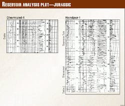
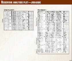
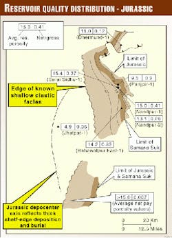
Lower Jurassic Datta sandstone is the main reservoir at Toot and subsidiary reservoir at Meyal and Dhulian oil fields (Figs. 1, 2). Net pay porosity averages up to 15-18%. Deposition is deltaic, and sands have the appearance of stream-mouth point bars, prograding westward and downward to proximal distributary mouth bars. Most sands grade coarser upward in a cylic manner with a well-developed shale as base. These are cycles of progadation sequence in which a delta is moving outward from the east into a standing body of water to the west.4
The Middle Jurassic Chiltan formation was drilled in wells including Nabisar, Digh, Patar, Talhar, Bhadmi, and a gas reservoir in Zarghum. Formation thickness, 420 m in the Nabisar well comprised shelf limestone with pisolitic to oolitic character, increased to more than 983 m in the Digh well (Figs. 1, 2). The Jurassic depocenter axis reflects thick shelf-edge deposition and burial. Chiltan has negligible intergranular porosity but may have secondary porosity due to fractures and vugs.
Deposition of the middle and basal sands of Lower Cretaceous Lower Goru occurred in a shoreline setting with actual environments ranging from marine shelf to fluvial channels. Late Cretaceous-Early Tertiary trapping of hydrocarbons could have resulted in local preservation of reservoir quality. These reservoirs contain well-preserved sequence boundaries that have clear potential to be picked up on seismic sections and mapped, assisting in delineation of stratigraphic traps.5The upper sands' depositional environment has been largely controlled by interaction of major inter-regional eustatic trangressive-regressive cycles with structural evolution of the Indus basin.6
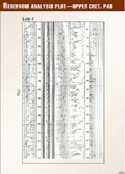
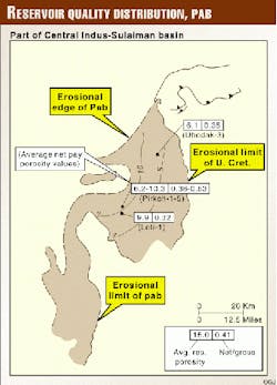
The Upper Cretaceous Pab sandstone is a gas and condensate reservoir in Dhodak, Rodho, Loti, and Pirkoh fields in Cental Indus formed in low energy marine environment. Recently it has been found gas bearing in Sui deep and Mari deep and the Zamzama and Bhit wells in Lower Indus. In the latter two wells it represents a product of a tide modified, braid delta system with moderate to very good porosities (Figs. 3, 4). It can be divided into nine reservoir units based on recognition of surfaces believed to be of sequence stratigraphic significance.7
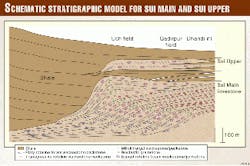
Paleocene is the most prolific reservoir after Low- er Cretaceous/Lower Goru and is productive at Dakhni, Chak Naurang, Dhulian, and Meyal (Upper Indus), Dhodak, Loti, and Pirkoh (Central Indus), and Hundi and Sari (Lower Indus). Eocene carbonates are commercially the most significant in Pakistan and comprised of widespread carbonate platforms and shale basins (Fig. 5). A study of the geological history of the distribution of Laki sediments suggests that Laki was deposited in relative shallow areas where conditions could have favored organic growth. Lack of horizontal layering at some places in the seismic picture is anomalous.
In the Lower Indus/Kirthar basin all the proven reservoirs have fair to good producibility (5-10 MMcfd for Upper and Lower Ranikot; more than 20 MMcfd for Pab at Bhit and Zamzama). Porosity of Upper Ranikot limestone is 8-15%. Migration of gas into structures has been from Lower Cretaceous shales via extensional faults and more recent thrust faulting. The TCF reported for the Bhit and Zamzama wells shows that adequacy of source rock is not a problem even for relatively young structures in the fold belt.
The Authors
Mrs. V.N. Quadri served Oil & Gas Development Corp. from its inception, retiring as acting general manager of exploration after nearly 30 years' service. E-mail: [email protected]
S.A. Chughtai is manager exploration for OGDC. He is a geophysicist with more than 30 years' experience.
Z. Farani is chief geophysicist and has more than 20 years of service with OGDC.
G.J. Quadri has been regional manager of the public sector of OGDC.
Next week: The authors recommend where to drill in Pakistan for the best chances of finding giant fields.
