Potential outlined for Kamchatka back-arc basin, Far East Russia
The Kamchatka back-arc basin is a relatively unexplored petroleum region of Russia. Similar in many respects to the Sumatra basin of Indonesia, this region of Russia has the promise of becoming a major producing region.
The geology of the Kamchatka Peninsula has been described previously by several workers, including most recently Oleinik,1 Kostenko et al.,2 and Grigorenko et al.3
Worrall4 described the tectonic history of the Bering Sea with particular attention to the Tertiary strike-slip basins of the Bering shelf.
This article describes the petroleum geology of the Kamchatka region and the challenges of operating in this remote environment.
Regional tectonic framework
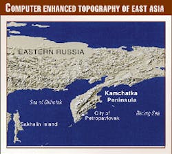
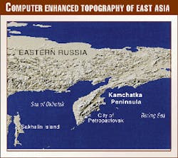
Kamchatka is located in a tectonically complex region at the junction of the Kurile and Aleutian subduction zones. The peninsula is predominantly a volcanic arc formed by the subduction of the Pacific Plate along the Kurile trench and by uplifted and thrusted Mesozoic sediments west of this volcanic arc. A computer enhanced topographic map of northeastern Asia shows the region, illustrating the main topographic features of Kamchatka (Fig. 1).
Bering Sea
Benioff zone earthquake epicenter data show that the Pacific plate is subducting at a relatively steep angle of 60° beneath the Kamchatka peninsula. The Kurile and Aleutian subduction zones converge at a point off the east coast of central Kamchatka and, at the point of convergence, the movement of the Pacific plate along the Aleutian arc is almost entirely strike-slip. Landward of this point of convergence exceptionally large volcanoes are present, probably formed as a result of deep seated crustal fractures, including the Kluchevskoy volcano, which with a height of 4,750 m is Asia's highest and most active volcano.
North of the Aleutian arc, Tertiary spreading along the Kommandorsky spreading center resulted in the development of a large thrust system in northern Kamchatka, the Vatnya thrust. Movement along this thrust fault system is translated along strike into strike-slip movement along a major fault bisecting the Kamchatka Peninsula, the Kamchatka fault.
Transtensional movement on this fault system during the Tertiary resulted in the formation of a sedimentary trough, the Kamchatka central basin, located on the eastern side of the Kamchatka fault. This basin occupies the prominent valley in the center of the Kamchatka peninsula. Seismic data and exploratory drilling in the southern part of this trough have demonstrated the presence of a sequence of marine sediments greater than 6,000 m in thickness.
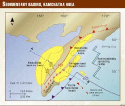
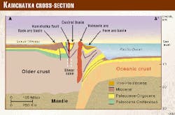
On the western coast of Kamchatka and extending into the Sea of Okhotsk, regional subsidence since the late Cretaceous has resulted in the formation of the Kamchatka back-arc basin. Figs. 2 and 3 show these major structural features and sedimentary basins.
The Kamchatka back-arc basin underlies the western coastal region of Kamchatka, which is flat tundra coastal plain without permafrost, well suited to petroleum operations.
Exploration has been sporadic in the area since the 1930s commencing with surface geological mapping and the drilling of shallow wells on surface anticlines. A very small gas discovery was made in 1973 at Limon, in the central basin area.
In 1986-88 several significant gas-condensate fields were discovered in the Kolpakovsky region in the central part of the Kamchatka back-arc basin. About 15,000 km of seismic data were acquired in this area between 1986 and 1994, and 26 exploration wells were drilled since 1982. These data provide a good database which has illuminated the structure and stratigraphy of the area. A study of this detailed geology is useful in providing depositional and structural models for use in regional exploration.
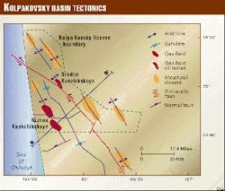
Significant structures and faults in the Kolpakovsky area were identified through the acquisition of this seismic and drilling data (Figs. 4 and 5).
A large left lateral strike-slip fault cross-cuts the map area. This fault is one of a family of faults cross-cutting the Kamchatka back-arc basin that were identified from surface geological mapping. Oriented at approximately 30° to the Kamchatka fault, vertical throw changes dramatically along strike, from in excess 1.5 km upthrown to the east, to 0.5 km upthrown to the south. The stratigraphy found in wells drilled on opposite sides of the fault is quite different, suggesting that lateral movement on the fault may be quite large. The fault throw extends to the surface indicating that very recent movement has occurred.
Nihzne Kuakchikskoye field, discovered in 1988, is the primary gas condensate field in the Kolpakovsky area. Its total recoverable reserves are currently 350 bcf of gas and 4 million bbl of condensate in one contiguous reservoir. The gas condensate reservoir, a Paleocene sandstone at a depth of 7,700 ft, has an average thickness of 105 m and an average porosity of 21%. Net pay at the crest of the structure is 344 ft, with average net pay of 110 ft. The average productive capability per well is 6.1 MMcfd. The field area is not fully delineated, and significant reserve additions are likely.
Kshukskoye field, 4 km north of the Nihzne Kuakchikskoye field, has six vertically stacked Miocene sandstone reservoirs with modest reserves of 80 bcf of gas and 1 million bbl of recoverable condensate. These fluvial sandstone reservoirs, interbedded with coal and siltstone, have thicknesses from 2-8 m and average porosity of 24%. Each reservoir is restricted in extent so that completion and production of gas from this field are likely to be relatively small.
At Kshukskoye, the thick Paleocene sandstone reservoir, which is productive at Nihzne Kuakchikskoye, has not yet been penetrated due to high overpressures. Very large reserve additions of gas and condensate are possibly present beneath the existing pool area.
Sredne Kunzhikskoye field (Fig. 5) also has modest gas reserves in the Miocene sandstone reservoirs, and in addition tested 34° gravity, light, slightly waxy crude oil from a siltstone in the lower Paleocene. Similar waxy crude oil tests were recorded in numerous wells in the northern part of the Kolpakovsky area.
Figs. 4 and 5 also show the large east-west oriented extensional fault separating Nizhne Kuakchikskoye field and Kshukskoye field. Movement on this fault is in excess of 3,000 ft, and it appears to have controlled the deposition, during the Paleocene, of a thick syn-rift sequence of sandstone and conglomerate which is the good quality gas-condensate reservoir at Nizhne Kuakchikskoye.
Exceptionally large tilted fault block structures on the downthrown side of this fault system, within the sedimentary trough, are untested. The only well to penetrate this sequence, drilled in Kshukskoye field, encountered overpressures below 12,000 ft and blew out.
The petroleum source rocks in the Kamchatka back-arc basin are unknown but are likely to be syn-rift lacustrine sediments deposited during the late Cretaceous and early Tertiary within the graben areas formed during the early extensional period of basin evolution.
The geothermal gradient within the Kolpakovsky part of the Kamchatka back-arc basin is relatively low-1.84° F./100 ft. The maximum depth of burial of the source rock section is unknown but may be in excess of 5,000 m in the offshore area. It is likely that both gas and oil have been generated through the basin's Tertiary history. The discovery of light waxy crude oil in the updip portion of the basin5 and gas-condensates in the deeper structures suggests that early migrating oils may have been displaced, into up-dip structures by gas migration.
Systems compared
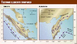
The back-arc basins of Sumatra and Kamchatka have both been influenced by the large strike-slip fault systems at the boundries of the basins (Fig. 6). Secondary strike-slip faults oriented at approximately 30° to the main fault crosscut both basins. Mid-basin arches, oriented approximately 90° to the major strike-slip fault systems, are present in both areas.
Relatively early extensional faulting controlled the deposition of clastic reservoirs in both basins-in the case of South Sumatra the deposition of the Oligocene Lemat and Talang Akar sediments was controlled largely by this early extensional faulting. In Kamchatka the Paleocene sandstone reservoirs were deposited in response to the late Cretaceous extensional block faulting.
In Sumatra and in Kamchatka, these early extensional fault systems were subsequently folded in response to compressive strike-slip movement.
Petroleum lacustrine source rocks were deposited in the early stages of basin development in both areas, producing waxy, relatively high pour-point crude oils.
The average recorded geothermal gradient in Kamchatka, 1.84° F./100 ft, is significantly lower than in the Sumatra back-arc basin, which has an average geothermal gradient of 2.89° F./100 ft.6
These relatively cool back-arc gradients in Kamchatka may be the result of the very steep angle of subduction of the Pacific plate beneath Kamchatka (65°).
Operating challenges
CEP International Petroleum Ltd. in partnership with the local operating company Kamchatgasprom is undertaking an exploratory drilling program on the west coast of Kamchatka.
Three wells are scheduled to be drilled during the winter of 1999-2000. The area is flat coastal tundra plain without permafrost and winter roads allow good access from the period December-April. The coastal plain area, however, is wet and difficult to access during the summer months. Imported materials and drilling equipment are shipped to the all-season ice free port of Petropavlovsk and then by barge to be offloaded at docks located at several fishing communities along the west coast of Kamchatka.
Like other prolific petroleum basins along the Pacific Ring of Fire, the Kamchatka back-arc basin offers the potential for the discovery of large petroleum reserves. The basin offers the appealing combination of rich source rocks, good reservoirs, and seals and the presence of large untested structures.
Acknowledgments
The authors thank the directors of CEP International Petroleum Ltd. and Kamchatgasprom for permission to submit this material. Our work in the Kamchatka Region would not have been possible without the strong support of the Governor of the Region, Vladimir Biroukov, for which we are grateful. Dr. Patoka, deceased, the former Director General of the Kamchatka GEOLCOM, assisted greatly. The article has benefited from discussions held with staff of the Vinigri institute in St. Petersburg and with staff of BC Gas International.
References
- Oleinik. A.E., Paleogene sedimentary basins and paleogeography of western Kamchatka, AAPG 1998 annual meeting expanded abstracts.
- Kostenko, N.P., and Korchuganova, N.I., Structural and geomorphological exploration of ore deposits; application of method to nonmetal deposits and petroleum exploration, Bull. Moskovskogo Obshchestva Ispytateley Prirody, Otdel Geologicheskiy, Vol. 72, No. 3, 1997, pp. 60-64.
- Grigorenko, Y.U., Margulis, L.S., Voronkov, Y.S., and Radchenko, V.G., North Okhotsk-West Kamchatka zone of Cenozoic subsidence; the most important object for discovery of large hydrocarbon accumulations, AAPG Bull., Vol. 81, No. 8, 1997, p. 1,379.
- Worrall, D.A., Tectonic history of the Bering Sea and the evolution of the Tertiary strike-slip basins of the Bering shelf, GSA Special Paper 257, 1995.
- Kudryavtseva, Y.I., Krylova, T.A., Avdeyev, A.S., Makhov, S.F., and Blokhina, G.G., Carbon isotopic composition of oil, condensate, and gas of West Kamchatka in connection with migration and oil-gas accumulation, Petroleum Geology, Vol. 31, No. 2, 1997, pp. 192-195.
- Eubank, R.T., and Makki, A.C., Structural geology of the Central Sumatra back-arc basin, proceedings of the Indonesian Petroleum Association, Vol. 10, No. 1, 1981, pp. 153-196.
The Authors
Robert Maxwell is a Canadian professional geologist with 20 years experience in international petroleum exploration. He worked for Shell during 1977-82 and later for several major companies in Indonesia, Libya, Egypt, and Cuba. Since 1998 he has been president of CEP International Petroleum, active in exploration in North Africa and Russia.
He obtained an MSc degree in geology from the University of British Columbia. E-mail: [email protected]
Rustam Chinakayev is a geophysicist with 20 years' experience in seismic acquisition and interpretation. He was chief geophysicist for the scientific cruise of the M/V Prof. Kurentsov, involving acquisition and interpretation of regional seismic lines across the southern Atlantic Ocean. He has been vice-president of CEP since 1998. He was graduated from Kazan State University and in 1988 received a PhD in geophysics from USSR Academy of Science.
