Morocco's Tarfaya deepwater prospects encouraging
Recent work by Enterprise Oil has shown that the deepwater extension of the Tarfaya basin, located in the Atlantic Ocean off western Morocco, has the potential to become a major hydrocarbon province.
As outlined below, all the key geological elements are present. Further, the region bears many similarities to other highly productive Atlantic margin basins, such as the Gulf of Mexico, the Campos basin of Brazil, and offshore Eastern Canada (which lay alongside the Tarfaya basin prior to rifting).
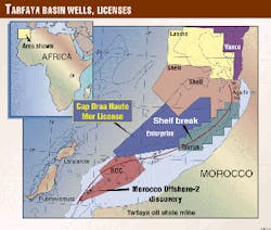
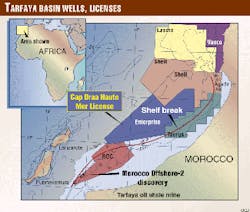
Several companies have recognized this potential, and this has led to a recent flurry of licensing (Fig. 1). Drilling within the next few years will reveal the true potential of the region. Enterprise Oil has presented some aspects of its preliminary studies at the recent European Association of Geoscientists and Engineers conference in Helsinki. An update of this work is due to be presented at the upcoming American Association of Petroleum Geologists International Conference in Birmingham, England, this September. This article summarizes our main conclusions.
Tarfaya basin
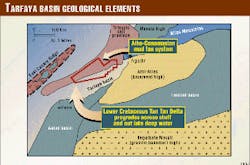
The Tarfaya basin trends northeast/southwest and lies onshore and off western Morocco, south of the Atlas Mountains (Fig. 2).
To the south it extends into the Aaiun basin, while its western margin is defined by the East Canary Ridge. To the east and southeast lies the Northwest African craton, superimposed upon which is the largely Paleozoic Tindouf basin. In the onshore and shelfal parts of the basin, Cretaceous and younger rocks are exposed. To the north of the shelf break, however, a thick Tertiary section is developed in 500-2,500 m of water.
Eighteen exploration wells have been drilled in the offshore part of the Tarfaya basin (Fig. 1). All were located on the shelf.
In 1970, Exxon's second well (Morocco Offshore-2) encountered heavy oil in a Jurassic reefal structure. Two subsequent appraisal wells proved the existence of a subcommercial heavy oil accumulation, as well as the presence of lighter (38° gravity) hydrocarbons. To the north, off the town of Agadir, a number of companies drilled a cluster of five wells during the 1970s-80s. While shows were seen in most of them (and some are associated with hydrocarbon indicators on seismic), the lack of decent reservoirs overlying salt-related features has resulted in them all being classed as unsuccessful.
Exploration beyond the shelf break has been limited to date. Exxon held licences over the area in the mid-1970s and acquired reconnaissance seismic. It also drilled a well (Haute Mer-1) in about 500 m of water. This well unfortunately failed due to lack of reservoir. Further exploration of the deepwater plays was prohibited at that time due to water depth.
Over the last 18 months, spurred by the advances in deepwater technology and improving contractual/fiscal terms, a number of companies have been lured back to the area. Enterprise Oil led the way (in December 1997) followed by Shell, Roc Oil, and Lasmo.
Tarfaya geology
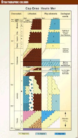
Rifting of the central Atlantic began during the Triassic (Fig. 3). Salt was deposited by early marine incursions into the rift system, intercalated with fluvial clastics. A major marine transgression, associated with the switch from rift to drift phase at the start of the Jurassic, flooded the region and initiated the development of a carbonate dominated environment in the shallower water shelfal area. A major continental shelf break bounding an extensive Late Jurassic carbonate platform developed at that time and has remained a dominant feature of the region until the present day.
During the Lower Cretaceous a major delta system (the so-called Tan Tan delta) prograded across the region from the south and east, drowning the carbonate platform (Figs. 2, 4). In shelfal wells the deltaic sequence can be divided in two; lower, more argillaceous delta toe-sets, unconformably overlain by more sandy delta top-sets.
Sediments were sourced from the Tindouf basin and on the West African craton to the southeast. Following deposition on the shelf they were re-worked into the deeper water environments by debris flows and turbidites, where they accumulated in a northward thinning wedge. These distal, deepwater derived turbidites are today exposed in cliff sections on the island of Fuerteventura.
Brief duration lowstands resulted in the erosion of delta top sands (and created unconformities on the shelf), with redeposition as basin-floor fans. Two such episodes are predicted; one associated with the mid Tan Tan change from muddy to sandy sediments seen on the shelf, and another associated with the upper boundary of the unit, in the basal Aptian.
In the Albian the sediment supply from the southeast diminished and the shelfal areas were transgressed. A thick mud dominated sequence of sediments was deposited, infilling the deepwater basin topography. The sediments were sourced from the Atlas Gulf (a narrow rifted seaway to the northeast that was subsequently inverted to form the Atlas Mountains during the Tertiary-see Fig. 2).
Gradual transgression throughout the Albo-Cenomanian resulted in extensive flooding and the development of thick shelfal oil prone source rock facies which are preserved in many places along the Moroccan Atlantic Margin.
The top of the Cretaceous section and base of the Tertiary is marked by a highly erosive unconformity, formed by uplift of the hinterland and slope re-equilibration. It is overlain by a complex sequence, which on seismic is comprised of slumps and high amplitude, laterally continuous reflectors, thought to represent coarse grained turbidites. In places bi-directional downlaps indicative of fan geometries are present.
A seismically opaque zone, thought to represent hemipelagic shales, overlies this basal high amplitude package. In the mid-Oligocene the Atlas Gulf inverted to form the Atlas Mountains. Regional uplift associated with this event generated a second major unconformity in the Tertiary section. It is overlain by another high amplitude package, indicative of a second phase of coarse-grained turbidite deposition. A seismically opaque sequence thought to indicate hemipelagic mudstones and shales overlies the high amplitudes and represents the Miocene to Recent succession.
The Lower Jurassic. Good quality oil prone source rocks associated with the regional transgression are known to exist on the shelf, but little is known of the deepwater region. However, the depth of burial of the Lower Jurassic is significant. Consequently, the unit is probably post-mature for hydrocarbon generation over much of the basin.
The Lower Cretaceous deepwater Tan Tan delta equivalents. Data from the shelfal wells show that the lower, more argillaceous, deltaic sediments contain terrigenous, Type III kerogens that could be potential gas source rocks. Similar kerogen types are found in the distal delta toe-sets. In areas away from the delta influence there is evidence of the deposition of Type I and II kerogens in anoxic environments (cf. the Alisio 15A-1 well drilled in the Aaiun basin to the south).
The Albian mud fan system that developed out of the Atlas Gulf to the northeast. Well data suggest that this unit contains TOCs of up to 2% of Type II and III kerogens. Additionally, the Albian in the Central Atlantic region is characterized by anoxic events and the development of thick, high TOC black shale sequences. Hence, away from the influence of deltaic processes, the background sedimentation is likely to be highly organic and an excellent source rock.
The Cenomanian was a period of very high sea levels. Flooding of the Atlas Gulf resulted in the Atlantic Ocean connecting with the stagnant/nutrient rich Tethys. As evidenced along the entire Central and North African Atlantic Margin a major upwelling zone developed in the region. The result was the deposition of thick sequences of potential source rock. At Tarfaya, on the present day coast of Morocco, a 680 m sequence of shelfal marls was deposited, with TOCs of up to 7.4%. Off Agadir, several wells encountered oil prone kerogens and TOCs of up to 7%.
The Lower Tertiary interval has been analyzed in a number of wells and found to contain TOCs of up to 4.6%. The presence of Type I and II kerogens suggests it could be a fair to good source for oil. However, maturity levels are thought to be low (see below).
Of the five intervals, the Albian and Cenomanian offer the best potential for the region, with good secondary potential lying in the Lower Cretaceous and Lower Tertiary.
Hydrocarbon charge
Computerized 2D basin modeling suggests that the key Albo-Cenomanian interval became mature and started expelling hydrocarbons in the Eocene in the deeper parts of the basin. As the Tertiary progressed the area of oil window spread gradually updip and landward across the area so that by the end of the Miocene the entire area seaward of the shelf break was in the oil window and generating hydrocarbons.
This modeling exercise suggested that the Tertiary sequence would not attain maturity. However, addition of elevated geothermal gradients associated with the Oligocene emplacement of the East Canary Ridge could prove sufficient to allow maturation of the Tertiary section in the northeastern part of the deepwater Tarfaya basin.
Numerous shallow seismic anomalies as well as amplitude brightening and flat spots on the flanks of salt features are present in the area. These are indicative of the presence of reservoired hydrocarbons and suggest that a working hydrocarbon system exists in the basin.
Reservoirs, seals
Four reservoir units have been identified as offering potential in the area. These are:
- The Lower Cretaceous. The deepwater equivalents of Tan Tan delta sediments contain two types of reservoir/seal couplet. Shingled turbidite sands are predicted to be present having formed following the mass movement of Upper Tan Tan sandy delta top-set facies down into the basin. Interbedded hemipelagic shales would provide seal to these reservoirs. Secondly, basin-floor fan sands may exist associated with the mid Tan Tan unconformity seen in the shelfal wells. The overlying hemipelagic shales provide seal to this reservoir.
- Aptian basin-floor fan sands. Detailed sequence stratigraphic analysis suggests that an as yet unproven reservoir may exist in the basin. This model is supported by evidence of coeval erosional channels and coarse clastic infill seen in a proximal setting onshore and time equivalent analogues seen off the American Atlantic coast (in DSDP well #603). The regional mid-Cretaceous Albo-Cenomanian mudstones provide a seal for this reservoir unit.
- Paleocene to Eocene turbidite sands, sourced from the cratonic areas onshore and deposited directly into the deepwater basin. Overlying hemipelagic shale units would seal this reservoir.
- Oligocene turbidite sands, deposited following further uplift of the African hinterlands. Miocene to Recent hemipelagic shales seal the sand reservoir.
Additionally, reservoir potential may exist in other units:
- Jurassic deepwater clastics, though they would be deeply buried.
- Jurassic talus slope deposits-debris from the steep reefal margin has collapsed into the deepwater and provides potential for additional reservoirs.
Traps
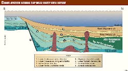
The principal mechanism for the generation of structural traps in the region is halokinesis (Fig. 4). Salt movement started in places in the Jurassic and has continued right through until the present day. The result is that salt flank and drape anticline traps are common. Between areas of strongly diapiric salt are larger, lower relief anticlines overlying salt pillows.
Mapping of a c. 6 by 6 km grid of seismic data (acquired in 1998) over Enterprise's 12,444 sq km Cap Draa Haute Mer license identified over 100 structural leads ranging in size from in excess of 160 sq km down to less than 3 sq km.
Four features were greater than 150 sq km, and six were larger than 100 sq km. Clearly, reserve volumes in features of these dimensions could be very significant.
Potential stratigraphic trapping mechanisms are also present and are particularly obvious on seismic in the Lower Tertiary section. Here, high amplitude reflectors that lap-out against the sides of channel systems indicate that channel-fill traps may be viable. Downslope, bi-directional down-laps suggest the presence of fans, which could also form trapping morphologies. Deeper in the section, Jurassic talus debris slopes may have developed in the deepwater against the steep slope edge. The updip pinchout of these bodies can form stratigraphic traps.
In early 1999 Enterprise infilled its existing seismic grid with the acquisition of an additional 3,800 km of 2D seismic data, giving a c. 3 by 3 km grid. Mapping of the new data is in progress and will allow updating of the prospect and leads inventory.
Plays
Combining the elements outlined above allows the development of the five principal plays that are present in the area (Figs. 3 & 4). From oldest to youngest, they are:
- Lower Cretaceous basin-floor fan sands, capped by deepwater shales and sourced by underlying delta toe-sets or hemipelagic shales.
- Lower Cretaceous shingled turbidite sands re-deposited down-slope of the upper Tan Tan delta sandy top-sets. Interbedded hemipelagic shales act as seal and source.
- Aptian basin-floor fan sands sourced and capped by overlying Albo-Cenomanian shales.
- Lower Tertiary turbidite sands capped by Eocene/Oligocene shales and sourced by underlying Albo-Cenomanian shales.
- Oligocene turbidite sands sealed by overlying shales and sourced by either Albo-Cenomanian or Lower Tertiary shales.
Other, higher risk plays include: - Lower Tertiary sands in stratigraphic, channel-fill traps, capped by Eocene/Oligocene shales and sourced by the underlying Albo-Cenomanian.
- Jurassic talus slope deposits forming the reservoir and stratigraphic trap, capped and sourced by Lower Tan Tan shales,
- Jurassic deepwater sandstones, sealed by intraformational shales and sourced by the Lower Jurassic.
Conclusion
Eighteen months of study indicate that a considerable number of different play types are present in the deepwater Tarfaya basin off Western Morocco. These plays have been successful in several other basins surrounding the Atlantic Ocean.
All that remains is for some wells to test the play concepts described above and prove up the presence of another Atlantic margin hydrocarbon province.
The Authors
Jerry Jarvis is a senior geophysicist in the International Exploration and New Ventures Group at Enterprise Oil plc, where he has been employed since 1997. He joined Sun International in 1987 and worked on exploration projects in the North Sea, Africa, and South America. In 1993 he moved to Fletcher Challenge Energy in New Zealand. He was graduated in 1981 from Dundee University in Scotland with a BSc (Hons.) degree in geology before moving to Imperial College, London and completing a PhD in 1985. E-mail: [email protected]
Philip Fish has worked as an exploration geophysicist for several major oil companies for the past 17 years. He joined Enterprise Oil plc in 1997 and works in the technical center. He was graduated from Reading University, U.K., with a degree in geological geophysics in 1982.
Toby Garwood is a senior explorationist in Enterprise's International Exploration and New Ventures Group. He spent eight years working on various North Sea E&D projects before joining the International New Ventures Group 18 months ago. He was graduated from University of London's Goldsmith College in 1989 with a First Class BSc (Hons.) in geology and obtained an MSc with distinctions in basin evolution and dynamics from University of London's Royal Holloway and Bedford New College. E-mail address: [email protected]
