Great South basin, New Zealand, might hold considerable potential
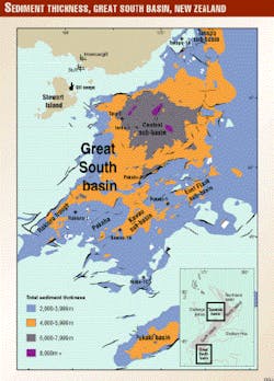
New Zealand`s underexplored Great South basin covers an area of about 100,000 sq km off the southeast coast of the South Island (Fig. 1). Much of the basin lies beyond the modern continental shelf area in 100-1,250 m of water (average about 700 m). Port facilities are at Bluff near the small city of Invercargill, about 150 km from the basin center.
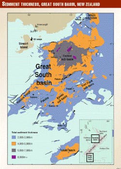
The Great South basin is a complex intracontinental rift formed during the mid-Cretaceous, with several distinct sub-basins containing up to 8.6 km of sedimentary fill. The extent of the basin can be defined by the 2,000 m total sediment thickness isopach (Fig. 1).
Exploration history
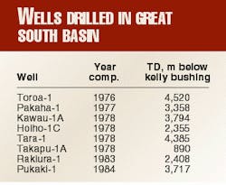
Hunt International Petroleum Co. Ltd. and its partners began an aggressive exploration campaign in 1969, acquiring over 30,000 line km of seismic data by 1982. Between 1976 and 1984, the consortium drilled eight wells (Table 1), finding hydrocarbons in half of these. Hunt relinquished its license in April 1985.
Although other companies acquired additional seismic data and/or reprocessed existing data during the 1980s and 1990s, no further wells have been drilled. Antrim Oil & Gas Ltd. explored the basin most recently. It was awarded a permit in 1997 over 25,000 sq km of the central part of the basin. Antrim relinquished the permit in March 1999.
Basin stratigraphy
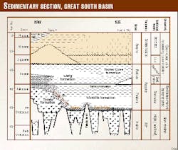
The sedimentary section is divided into four groups1 2(Fig. 2), defined by regional unconformities tied to the eight offshore wells and corresponding to changes in tectonic and/or sedimentary setting of the basin.
Identification of economic basement is not clear everywhere in the basin. Seismic data are generally of poor quality at depth, and the most deeply buried sedimentary units have not been drilled. While the oldest strata mapped have been assigned an Albian or possibly Cenomanian age, there are strong indications on seismic data that significant thicknesses of older sedimentary units are present.
The Cretaceous synrift basin fill is assigned to the Hoiho Group, which is inferred to range in age from about 105 to 85 Ma. Seismic interpretation suggests that much of the group is composed of coarse clastic sediment. Basin morphology, dominated by the elevated northwestern margin of the basin and the Pakaha horst, was controlled by active normal faults. Slope-fan and slump deposits formed adjacent to faults, while broad alluvial plains formed in distal areas.
The deepest and most extended parts of the basin, particularly the Central sub-basin, accumulated well stratified lacustrine or restricted marine deposits fringed by deltas and heavily vegetated plains, swamps, and estuaries. Only the upper part of the Hoiho Group has been sampled. It is non-marine, but C30 steranes and high sulfur contents in oils from Hoiho Group sediments indicate some marine influence.3
The Kawau sandstone defines the base of the Pakaha Group, formed in response to regional subsidence and extensive marine flooding from about 85 Ma. Deposition of nonmarine sediments continued along the northwest margin, forming the Taratu formation, while marine silts of the Wickliffe formation filled deeper parts of the basin. Shallow-marine sandstones and organic-rich lower coastal plain sediments were deposited near the steadily transgressing shoreline.
Some uplifted blocks remained emergent during the latest Cretaceous, but by late Paleocene time, deposition of clastic marine silts was widespread. The uppermost part of the Pakaha Group is marked by interbeds of organic-rich dark shale of the Tartan formation, deposited in restricted, possibly anoxic marine conditions.
The Eocene Rakiura Group is characterized in its lower part by thick submarine fan deposits in the Central sub-basin and a condensed section or unconformity in the southeast. A change to dominantly calcareous silt deposition marked a shift to open marine conditions. The group is progressively more calcareous towards the southeast, where the basin was more exposed to ocean circulation, pelagic sediment input was higher, and clastic input was lower.
Sediments of the Oligocene-Recent Penrod Group are dominated by pelagic carbonates, generally less than 500 m thick over most of the basin. Progradational Miocene-Recent shelf sediments extend over northwest parts of the basin.
Basin structure
The Great South basin has a complex horst and graben architecture (Fig. 1).
The main phase of basin development was synchronous with Hoiho Group deposition during an intense phase of mid-Cretaceous extensional tectonics, with rifting oriented approximately NNW. Hoiho Group strata generally have low dips and are displaced by moderate to steeply dipping normal faults in many places. Thickening of strata towards faults, local unconformities, and differences in bed thickness on either side of faults imply syn-depositional faulting. The largest displacements were on faults along the western margin of the basin and bounding the west edge of the Pakaha horst, where basement throw locally exceeds 3,000 m.
Rifting had ceased over most of the basin by about 80 Ma. Although there was little basement faulting during deposition of the Pakaha Group, open drape structures, such as those drilled by Pakaha-1, Pukaki-1, Hoiho-1C, Rakiura-1, and Kawau-1A were formed as Hoiho Group strata of varying thickness and were differentially compacted over pre-existing topography. Unconformities were developed above basement highs, with progressive onlap of overlying strata.
In the late Eocene, an extensional plate boundary propagated through southwestern New Zealand,4 5 evolving into the present-day active dextral strike-slip boundary. The southeastern limit of associated deformation is along the northwest margin of the Great South basin. Subdued structures formed farther south, two of which were drilled by Tara-1 and Toroa-1, but most of the basin remained undeformed. Because there has been so little post-rifting deformation of the basin, reservoirs and seals have not been affected by the same degree of tectonic disruption as some other New Zealand basins.6
Petroleum system
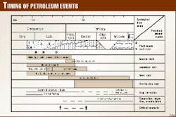
The petroleum system concept7 for developing exploration concepts and risks within a basin can be depicted on an events chart (Fig. 3) showing these parameters and the relative timing of their development. The "critical moment" is defined as the point that best depicts the generation-migration-accumulation of most hydrocarbons in a petroleum system.
All the requisite geological parameters for petroleum generation and entrapment are present in the Great South basin and have essentially been in place since about 70 Ma.2 Numerous shows in the few wells that have been drilled, combined with oil seeps onshore, demonstrate that hydrocarbons are present in the basin.
Hydrocarbon occurrences
Hydrocarbon indications were found in four of the eight wells that have been drilled in the basin. Two of these shows were highly encouraging. Oil seeps associated with surface fault traces on Stewart Island have similar Cretaceous source rocks as the condensate tested in Kawau-1A.
Kawau-1A had abundant hydrocarbon shows. Several Late Cretaceous sand intervals containing gas/condensate were encountered. Tests were carried out over the interval 3,224-3,329 m. A drillstem test of the primary gas/condensate reservoir over the interval 3,224-57 m in Kawau sandstone recovered gas at up to 6.7 MMcfd and 24 b/d of 47.8° gravity condensate. The sand had a yellow fluorescence and yellow to blue cut. Estimated P50 reserves on the Kawau structure are 217 bcf of gas plus condensate.
The Toroa-1 well was lost while setting pipe to test numerous gas and oil shows from 2,621 m (Paleocene) to TD at 4,520 m. Gas readings reached over 600 units C1-C5 in a Hoiho Group sandstone unit at 4,480-4,511 m. Gas cut drilling mud was observed over the same interval, which also had ditch sample fluorescence and a light yellow cut.
All shales and siltstone samples below 3,444 m gave a fluorescence and faint cut that improved with depth. Sandstones recovered in sidewall cores also had fluorescence, cut, and slight to strong gas odors from 3,575 m to TD. Ditch samples of sandstones contained fluorescence and cut shows from 3,261 m to TD.
The mud log recorded shows of oil from seven intervals from 3,459-4,495 m including dead oil stains, oil residue, and a few cuttings at 3,916 m "bleeding, thick, heavy, dark oil."
Tara-1 had minor gas shows as shallow as 1,200 m (Eocene). Several "tar" samples from 1,310 m and high gas readings may be from the abundant coals intersected in the well. Pakaha-1 had low-level gas shows in drilling mud throughout the Paleocene and Cretaceous section.
Sandstone ditch samples and sidewall cores in the Cretaceous interval below 3,100 m had slight to strong gas odors, with some fluorescence and occasional faint blue-white cut. In the Canterbury basin to the north, similar latest Cretaceous neritic sandstone in the Galleon-1 well tested both oil/condensate and gas up to 2,240 st-tk b/d and 10.6 MMcfd.
Source rocks
The Paleocene Tartan formation is an oilprone marine black shale and the richest potential source rock, and is probably mature in the deepest parts of basin. Late Cretaceous and Paleocene coals of the Hoiho Group and Taratu formation are buried more deeply than the marine Paleogene and are likely to be the principal source rocks.
Biomarker and isotopic correlation of the Kawau-1A condensate and potential source rocks suggest that the hydrocarbons were produced from mid-Cretaceous coaly sediments with significant marine influence.2 Cretaceous coals are particularly abundant in the Central sub-basin, and the 2,000 m of coal measures in Tara-1 span most of the Late Cretaceous to Paleocene.
New Zealand coals are generally hydrogen-rich, and although Hydrogen Indices suggest that they are gas-prone, research into the geochemistry of New Zealand oils indicates that their origins are primarily from coals and coaly material.3 Great South basin coals are comparable to coals of the same age range in the Taranaki basin that are the primary source rocks for petroleum produced there.
Maturation status
In addition to the direct measurements of present day maturity by reflectance and Rock-Eval studies, the maturation history of the Great South basin has been studied using thermal and hydrocarbon kinetic modeling.2 Generation would have begun locally by about 80 Ma.
The thermal regime of the sediments approached equilibrium by 45 Ma, and maturity has slowly increased since then due to the effect of time. The peak rate of potential oil generation occurred when burial depths of about 3,500 m were reached. Present day maturation levels in Tara-1, for example, indicate that significant generation begins at around 2,500-2,800 m and expulsion at 3,500-3,800 m depth.
Reservoir potential
Coarse clastic lithologies of Cretaceous age have the greatest reservoir potential and account for all hydrocarbon shows in wells (Fig. 2).
Cretaceous fluvial and lower coastal plain sandstone sampled from wells ranges in average porosity from 10-25%.
Shows in Kawau-1A were in the transgressive marginal marine Kawau sandstone (the primary gas/condensate reservoir tested) and in the underlying nonmarine Hoiho Group sandstones. Gas shows in Tara-1 were over a wide interval of Taratu formation coal measures, which include significant sandstones. Oil and gas shows in Toroa-1 were in nonmarine sandstones of the Hoiho Group and in the overlying coastal facies between the Taratu and Wickliffe formations. In Pakaha-1, shows were recorded in sandstones of the Taratu and Wickliffe formations.
Seals, traps - Abundant mudstone intervals are likely to form adequate internal seals, as they do in the Maui and Kapuni gas and oil fields of the Taranaki basin.
Most structures were in place by 80 Ma. Known or potential structural traps in the basin include:
- Fault traps associated with mid-Cretaceous normal faults;
- Drape structures formed during post-rift subsidence and controlled by the location of mid-Cretaceous structural highs; and
- Anticlines associated with minor Cenozoic shortening along the northwest margin of the basin.
Stratigraphic traps associated with unconformities and lateral facies changes have not so far been explored but are likely to be favorable targets.
Basin prognosis
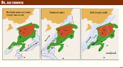
Known indications of oil and gas and the small number of wells drilled indicate a very under-explored basin with considerable potential. Fairway maps (Fig. 4) indicate the extent of the kitchen area for the expulsion of oil and gas at 45 Ma compared with areas where potential reservoir sands and gravels were most likely to have been deposited.
Only a few structures that were identified at top Paleocene level during the first phase of exploration have been drilled. More recent mapping8 9 has confirmed a large number of structures on several levels, particularly within Cretaceous strata. Five key prospect areas within part of the Central sub-basin are modeled9 as having 7.152 (P50) billion bbl of oil available for trapping and total recoverable reserves of 4,675 (P50) billion bbl. Some of these areas are predicted to be prospective mainly for gas, while others have potential for both oil and gas entrapment.
The basin is highly prospective because the deposition of adequate source, reservoir, and trap rocks, and the formation of primary structures occurred so early in the basin`s history. All the necessary components of a viable petroleum system were in place before the critical moment, which ranges from 70-45 Ma depending on location. Later deformation of the basin has been slight and may have caused secondary migration of hydrocarbons along the northwest margin, but it is likely that a relatively high percentage of hydrocarbons produced in the basin have been trapped. The basin is under-explored, and it is highly likely that commercial hydrocarbon accumulations will be discovered.
Available data
Petroleum industry exploration data for New Zealand are contained in Petroleum Reports held by Crown Minerals. All exploration data for the Great South basin are open-file. Over 30,000 km of seismic reflection data are available from about 400 lines acquired between 1968 and 1983. Most 1970s seismic lines are 12- or 24-fold, while 1980s data are 48- to 60-fold.
Extensive geological interpretation is included in oil industry compilations covering the whole basin carried out by Phillips Petroleum10 11 and BP.12
More recently, the Institute of Geological and Nuclear Sciences has carried out a comprehensive re-evaluation of seismic data, including integration with revised well paleontology and velocity data. Geological interpretations were compiled in the Great South Basin Petroleum Atlas,8 a series of 14 isopach maps, 12 structure contour maps, and eight paleogeographic maps at 1:500,000 scale. The institute has also published a monograph2 summarizing the basin`s geology and petroleum systems.
Acknowledgments
Underpinning this article are the data lodged by oil companies with the New Zealand government. Recent research on which this article is largely based was funded by the Foundation for Research, Science and Technology. Preparation of the article was funded by Crown Minerals of the Ministry of Commerce, which administers petroleum exploration in New Zealand; website is www.moc.govt.nz/crown_minerals
References
- Beggs, J.M., Depositional and tectonic history of the Great South basin, in Balance, P.F., ed., South Pacific sedimentary basins, Sedimentary basins of the World 2, Elsevier Science, Amsterdam, 1993, pp. 365-373.
- Cook, R.A., Sutherland, R., Zhu, H., et al., Cretaceous-Cenozoic geology and petroleum systems of the Great South basin, New Zealand, Institute of Geological & Nuclear Sciences Ltd., Lower Hutt, N.Z., Monograph 20, 1999.
- Killops, S.D., Cook, R.A., Sykes, R., and Boudou, J.P., Petroleum potential and oilsource correlation in the Great South and Canterbury basins, New Zealand Journal of Geology and Geophysics, Vol. 40, 1997, pp. 405-423.
- Carter, R.M., Plate boundary tectonics, global sea-level changes, and the development of the eastern South Island continental margin, New Zealand, South Pacific, Marine and Petroleum Geology, Vol. 5, 1988, pp. 90-107.
- Sutherland, R., The Australia-Pacific boundary and Cenozoic plate motions in the southwest Pacific: Some constraints from GEOSAT data, Tectonics, Vol. 14, 1995, pp. 819-831.
- Turnbull, I.M., Uruski, C.I., and others 1993, Cretaceous and Cenozoic sedimentary basins of western Southland, South Island, New Zealand, Institute of Geological & Nuclear Sciences, Monograph 1, 1993.
- Magoon, L.B., and Dow, W.G., The petroleum system, in Magoon, L.B., and Dow, W.G., eds., The petroleum system from source to trap, AAPG Memoir 60, 1994, pp. 3-24.
- Zhu, H., Great South basin petroleum atlas, 1:500,000 scale, 34 maps, Institute of Geological & Nuclear Sciences Ltd., 1998.
- Pearson, A.R., The Great South basin-Antrim International`s exploration strategy, 1998 New Zealand Petroleum Conference proceedings, Ministry of Commerce, Wellington, 1998.
- Inch, J.F., Geologic summary, Great South basin (offshore South Island, New Zealand), Phillips Petroleum Co. Far East, Singapore, New Zealand unpublished open file Petroleum Report 849, Ministry of Commerce, Wellington, 1978.
- Anderton, P.W., Holloway, N.H., Engstrom, J.C., Ahmad, H.M., and Chong, B., Evaluation of the geology and hydrocarbon potential of the Great South and Campbell basins, New Zealand unpublished open file Petroleum Report 828, Ministry of Commerce, Wellington, 1982.
- Woollands, M.A., An assessment of the hydrocarbon potential of the Great South basin, New Zealand in relation to the offshore Canterbury area, BP Shell Todd (Canterbury) Services Ltd., New Zealand unpublished open file Petroleum Report 1717, Ministry of Commerce, Wellington, 1978.
