Sedimentation study identifies exploration targets in South Turgay basin, Kazakhstan
Shi Juye
State Key Laboratory, Sinopec
China University of Geosciences
Beijing
After 40 years of exploration, large-scale structural reservoirs have become more difficult to find in Kazakhstan's South Turgay basin. China National Petroleum Corp. (CNPC) has increased its reserves in the basin by targeting lithological-stratigraphic traps to find subtle reservoirs in depressions in the basin's northern portion.1-4 Systematic research of stratigraphic sequences and sedimentary facies distribution can determine controlling factors of trap distribution and predict favorable hydrocarbon accumulation zones to further expand South Turgay basin exploration.
Future exploration in Kazakhstan's South Turgay basin should focus on lithological-stratigraphic traps related to two large lake-flooding periods with emphasis on the western Aryskum graben's fan bodies and the North Aryskum graben's slump bodies in. Cap rocks with excellent sealing capacities are more favorable for oil and gas reservoir formation in the South Turgay basin than in large-scale reservoir rock developments. Tectonic-paleotopographic settings are dominant factors controlling development sequences and favorable sand body distribution in both the Lower Jurassic and the Middle-Upper Jurassic's sedimentary facies belt.
This article identifies eight third-order sequences of the Jurassic in South Turgay basin by analyzing drilling logs, cores, and sedimentary and seismic facies from the region. The facies are characterized by lateral differences and vertical inheritances. The study also establishes corresponding relationships between seismic and sedimentary facies, which include fluvial, delta, fan delta, and lacustrine with other classified subfacies.
Exploration
Its large coverage area, uniform classification standards, and an unclear understanding of stratigraphic sequences and depositional filling patterns have restricted exploration of the complex South Turgay basin.
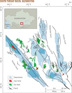
South Turgay, in south-central Kazakhstan, is one of the largest petroliferous basins in the country with an area of 80,000 sq km (Fig. 1). It is a Mesozoic-Cenozoic rift basin developed on the basement strata of the Jurassic and Cretaceous.5-8
CNPC has explored the majority of the Aryskum depression, contributing data from 150 wells, 875 2D seismic lines (18,856 km), and 14 3D seismic sections (2,474 sq km).
A previous study implemented wavelet analysis on integrated cores with logging and seismic data and identified sequence boundaries in the South Turgay basin, dividing the Upper Jurassic-Lower Cretaceous into four third-order sequences and 10 system tracts.9 The study then established stratigraphic sequence models of fault-depression conversion and depression stages, noting that the former developed during deposition of delta and shore-shallow lacustrine and the latter under fluvial deposition.
Analogous deposits in the Sarybulak region's Jurassic stratum helped identify three evolution stages in South Turgay:
• Fault.
• Fault-depression conversion.
• Depression.
These tectonic movements are thought to have occurred during the Jurassic and the Cretaceous.10
Geologic background
The South Turgay basin lies in the northern part of the Karatau strike-slip fault zone and is a typical strike-slip rift basin.11-13 The basin can be divided into three first-order tectonic units: the Zhilanchik depression in the north, Aryskum depression in the south, and Mynbulak uplift in the center.14 15 Newly discovered oil and gas fields are mostly distributed in the Aryskum depression, which makes up most of the basin, covering 40,000 sq km characterized by north-south distribution along its axis. As a Mesozoic rift basin, Aryskum developed on the earlier craton and is near the Ural-Tianshan stylolite, with the western Siberian basin to the north, Karatau uplift to the south, Ural-Heisey fold belt to the west, and the Kokshetau Block and Ulutau uplift to the east.16
The South Turgay basin features alternating horsts and grabens on the plane, presenting a rift pattern with four grabens and three horsts from east to west (Fig. 1).
This study divides the Jurassic in the South Turgay Basin into eight third-order sequences with nine sequence boundaries (Table and Fig. 1). These sequences contain two first-order unconformities, one second-order unconformity, and six third-order unconformities.
Sequence boundaries SB1 and SB9 are the first-order sequence boundaries, appearing as structural truncation surfaces within the entire basin. SB1 is the bottom-boundary (Paleozoic basement) of the Bozingen formation, overlying basement metamorphic rocks. SB9 is the regional truncation unconformity, J3ak, between the Upper Jurassic Akshabulak formation and the Lower Cretaceous Aryskum formation at the later fault-depression conversion stage. SB9 is distributed throughout the region and characterized by an angular unconformity, onlap and truncation, and denudation of most sequences forming basal conglomerate at the bottom of the Cretaceous.
SB7 is a second-order sequence boundary, as well as a downlap unconformity (J2kr) between the Karagansky and Kumkol formations. SB7 usually features truncation of the underlayer in the Bozingen graben in the east of the basin and onlap on the slope of the Aryskum graben in the south. In the Sarylan graben in the basin's north, SB7 appears as an integration of onlap and truncation. This results in differing characteristics of the wave group reflection from the upper and lower sequences, with weak reflection intensity over the boundary and increasingly strong reflection intensity under the boundary. Other third-order sequence boundaries in different tectonic zones are characterized by local unconformities, downlap and toplap surfaces, and depositional conversion surfaces.
Seismic facies
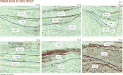
This study identified seismic facies among eight sequences of the Lower Jurassic-Lower Cretaceous in South Turgay basin using seismic reflection parameters, interior structures, and external forms of the seismic reflection, as well as characteristics of amplitude, frequency, and continuity. Owing to the large difference in seismic reflection between each Middle-Lower Jurassic sequence, lateral transformation of seismic facies is more conducive to classification than comparison and unification of different sequences. Successive analysis of each seismic section in the southern and northern basin provide characteristics that classify seismic facies into six types (Fig. 2). Some discrepancy exists among seismic facies in each vertical sequence, but general features and combined regularities can still be identified.
Progradational reflection in medium amplitude-medium continuity seismic facies is divided into S-shaped, imbricate, broom-shaped, and disordered configurations.17-20 Progradational reflection configuration is less developed in the research area, and is mainly distributed in the middle-lower part of SQ7 and SQ8 in the Akshabulak graben with an imbricate progradational reflection configuration. The top of this section displays toplap termination reflection without topset. But foreset is developed with reflecting layers parallel to each other having a medium reflection amplitude and long forward extension: the seismic response characteristic of delta front in a gentle slope environment (Fig. 2a).
Onlap filling seismic facies reflection is characterized by medium amplitude, medium-to-good continuity, and large distribution. It corresponds to the sedimentary environment of shore-shallow lacustrine, delta front, and semideep to deep lake, and is widely developed in SQ3 and SQ6 on the slope of different depressions (Fig. 2b).
Generally featuring medium amplitude, poor continuity, and disordered reflection, seismic facies tend to be continuous and stable depositions when approaching the center of a depression. Widely developed on SQ1, SQ2, SQ3, and SQ4 in the Lower Jurassic, the seismic facies usually correspond to braided river or fan deltas. The fan delta front has a better seismic reflection continuity but poor classification.
Alternating seismic events display trends of convergence or divergence, often with a large fluctuation in reflecting layers indicating a certain energy change in the sedimentary environment.21 22 Compared with seismic facies in medium amplitude, medium continuity, and parallel reflection, this type of seismic facies represents the medium to high energy of the sedimentary environment. Its external geometrical morphology is mainly in sheeted or filling shape, and sediments equally settle on the gentle slope or the broad plain in the western basin, reflecting the sedimentary environment's low energy and stable hydrodynamic force. This seismic facies is widely distributed in each tectonic unit in the north of the basin laterally and in SQ8 vertically, and it is the seismic response characteristic of fluvial facies and delta plain at the later stage of basin evolution (Fig. 2d).
Featuring strong amplitude and stable continuity, divergent filling reflection seismic facies increase and thicken toward one side of the seismic event. This attribute is mainly developed in SQ6 and SQ7 in the Aryskum graben and Sarylan graben, corresponding to the delta plain-delta front distributed along the depression edge of the Aryskum and the shore-shallow lake distributed in the depression center of the Sarylan (Fig. 2e).
Irregular reflection and poor continuity characterize disorder reflection seismic facies. These facies are developed in SQ1, SQ2, SQ3, and SQ4 in the Lower Jurassic at the earlier fault stage and mainly distributed near the basin edge or boundary fault, corresponding to a coarse clastic alluvial deposit or fan delta plain in an unstable environment with fast proximal sedimentation and high energy (Fig. 2f).
Logging indicators
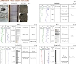
Despite abundant drilling in the South Turgay basin, limited in-situ core data exists. Sedimentary facies analysis is supported by basic data, such as core pictures from seven wells (Fig. 3a), petrographic descriptions from mud logging data of six wells (including rock type, mudstone color, mineral composition, and other characteristics), logging data from 30 wells-mainly spontaneous potential (SP), gamma ray (GR), sonic (DT), micro latero-log (MLL), and other logging curves-and other limited geologic data. Based on these data, Jurassic sedimentary facies in the research area are defined and divided into four types: fluvial facies, delta facies, fan delta facies, and lacustrine facies.
Fluvial facies include meandering river facies and braided river facies.23 24 The research area mainly consists of meandering facies, characterized by sandstone and siltstone lithology, coal seam, and a dual structure of fining-upward interbedded mudstone-sandstone (Fig. 3b). Channel-lag deposits feature a primary lithology of coarse sandstone mixed with gravel-gray, celadon, or brown in color-with box or bell-shaped SP and GR curves, and high amplitudes of anomaly response. Fluvial facies started developing vertically in SQ8 (Akshabulak formation) and laterally on the depression slope during geomorphological changes at the depression stage.
Delta facies are developed on the gentle slope belt at the fault stage and in most sequences at the depression stage. They can be divided into delta plain (Fig. 3c), delta front (Fig. 3d), and prodelta. Delta plain develops a distributary channel, characterized by a positive rhythm, a lithology of gray middle-fine sandstone, and a frequent scouring effect. SP and GR logging curves are dentate, box, or bell shaped. Delta plain also develops a distributary bay, which coexists with the distributary channel and features a lithology of mudstone interbedded with thin siltstone, silty mudstone, and argillaceous siltstone, as well as straight and tiny dentate logging curves.
Delta front includes underwater distributary channels, distant sand bars, and estuary dams. Delta front's total lithology sequence is fining upwards and logging curves are bell shaped, but the lithology sequences of both distant sand bars and estuary dams are coarse upwards with choanoid-shaped logging curves.
Fan delta facies emerge from alluvial fans and lakes as the alluvial fan is propelled by adjacent mountains into still water. The dynamic mechanism combines the dual actions of tractive and gravity currents. Fan delta is developed in Jurassic SQ3 to SQ6 and can be divided into fan delta plain and fan delta front. Fan delta plain is characterized by a lithology of thick conglomerates, sedimentary structures dominated by massive and graded bedding, simpler rock types and structural types than braided delta plain, and with logging curves fining upwards in bell or box shape with top-bottom lithology mutation. Fan delta front features a lithology of thick-layer, clast-supported sandstones with low maturity, medium sorting, and fining-upward logging curves in bell or box shape.
Lacustrine facies are continuously developed in each sequence in the research area, constituting the main filling body of the basin. Lacustrine facies include shore-shallow lake and semideep to deep lake deposits. Shore-shallow lake refers to the zone between flood level and wave base level, and is characterized by a lithology of gray and dark-gray mudstone or siltstone, a shallow water environment close to a lake surface, oxidation in brownish red, and a low amplitude and tiny dentate shape in SP and GR logging curves (Fig. 3e). Semideep to deep lake facies are dominated by fine-grained sediments with lithology of gray and dark gray mudstone and silty mudstone. Their logging curves are low-amplitude and straight. (Fig. 3f).
Vertical characteristics
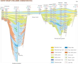
The well-tie profile (Fig. 4) is based on analysis of sedimentary facies and subfacies from 49 key wells in South Turgay basin. This comparative diagram reveals the lateral distribution of sedimentary facies. The wells are tied in an east-west direction spanning the Aryskum and Akshabulak grabens in the north end of the basin, revealing the development and evolutionary characteristics of sedimentary systems on the gentle or abrupt slope of each graben.
Aryskum graben's eight stratigraphic sequences (SQ1-SQ8) are complete due to the deposit's early development . Lateral distribution is reflected in the undrilled DOS010 and KAR18 wells according to seismic profiles. The Akshabulak graben consists of five sequences (SQ4-SQ8).
Sequence evolution and filling processes show sedimentary patterns of both inheritance and mutability, confirmed by well tie ins in northern South Turgay basin. Analysis of sedimentary facies evolution identifies three distinct parts.
SQ1-SQ3 mainly consist of fan delta and lacustrine facies. During the deposition of SQ1 and SQ2, Aryskum graben and Sarylan graben were at the early extensional rift stage. A double-fault controlling effect accommodated a large, fast-filling area during the early fault stage. Less water and more sufficient provenance in the basin deposited the fan delta in SQ1. SQ2 deposits included multiple thick glutenite, gravelly sandstone, and sandstone interbedded with mudstone. Sedimentary facies were fan delta as well as low-stand fan toward semideep lake. The sedimentary basin gradually enlarged and lake water deepened during SQ3 deposition. Well DOS010 identified retrogradation where deep lake facies began developing with gradual extensions of a range of shore-shallow lake and semideep lake deposits. The maximum flooding surface of SQ3 corresponds to the first large-scale lake transgression.
SQ4-SQ6 are deposition of the fan delta, normal delta, and lacustrine facies. Following SQ4 deposition, the water body became shallower, resulting in dominant shore-shallow lake facies, in contrast with the poor development of the semideep -to-deep lake facies. Attenuation of subsidence and expansion in the basin may be related to the decreased rate of structural sedimentation. Vertically, the environment of DOS010 changed from fan delta to shore-shallow lake with the deposition of SQ5, indicating a decreased rate of sediment accumulation and an undersupply of provenance. From SQ5 to SQ6, Aryskum graben transformed from fan delta to normal delta, with a decreasing proportion of fan delta facies and an increasing proportion of normal delta facies. Meanwhile, accompanied by deepening of the lake's water body, the deposition range of the basin began to enlarge. SQ6 is the second lake transgression, resulting in the change of most shore-shallow lake facies into shore-shallow and semideep lake facies as well as the retrogradation of the delta.
SQ7 and SQ8 are deposits of normal delta and lake sediment. Following the SQ7 period, the basin entered a fault-depression conversion stage and the lake area started to shrink. DOS11, DOS009, and KYZ67 well environments are mainly delta plain, and they gradually changed into delta front towards the basin center. In contrast with local development of braided river delta, normal delta facies were widely distributed during this period, and shore-shallow facies were developed in the graben center.
Favorable exploration areas
Two different structural-sedimentary settings exist in the Jurassic portions of the South Turgay basin. The settings are the early stage in the fault-restricting lake basin during SQ1-SQ4 deposition in the Lower Jurassic and the later stage fault-depression transforming into peneplain during SQ5-SQ8 deposition in the Middle-Upper Jurassic.
SQ1-SQ4 are characterized by development of faults, large differentiation of geomorphology, small ranges of the lacustrine basin, and fast changes of water depth. Their sequence development and favorable sand body distribution are dominated by tectonic-paleotopographic settings, which determine that the favorable reservoirs at this stage are mainly underwater fan sand bodies on the bluffy coast, undercut channel sand bodies, and slump sand bodies, all controlled by faults.
SQ5-SQ8 features flat sedimentary topography, small differentiation of geomorphologies, large ranges of the lacustrine basin, and shallow water body depths. Their sedimentary facies are mainly fluvial, floodplain, swamp, and delta plain, among which shore-shallow lake is widely distributed. In this setting, sedimentary facies dominate sequence development and favorable sand body distribution, determining that favorable reservoirs at this stage include different kinds of channel sand bodies, delta distributary channel sand bodies, and shore sand bars.
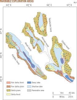
During the depositional stage of the Middle Jurassic Karagansky formation, the entire basin was at the middle-advanced fault stage. Compared with the Lower Jurassic, most local fan bodies in the Akshabulak graben and Bozingen graben were joined into fan groups. The Aryskum graben inherited the feature of the Lower Jurassic, but was dominated by western margin facies and lacustrine facies, with development of large-scale connected fan deltas in the graben edge along the minor axis and normal deltas along the long axis (Fig. 5).
Simultaneously, the northern Akshabulak graben was steep in the east and gentle in the west, developing a large-scale delta plain at the graben edge, as well as a delta front and shore-shallow lake in the graben center. The southern portion of Akshabulak graben is characterized by steep west and gentle east slopes, and a developing fan delta in its western portion. With expansion of the lake basin, coarse fan deltas in the grabens of Sarylan and Bozingen transformed into normal deltas, which were larger than those of the Lower Jurassic.
The Middle Jurassic developed reservoir sand bodies in sedimentary systems of delta, fan delta, and shore-shallow lake. Mudstone forming in the second large-scale lake flooding provided good sealing conditions and source rocks for the formation of oil and gas reservoirs. Paleogeomorphic configuration and reservoir-cap combinations during lake flooding present two favorable sedimentary facies in the Middle Jurassic Karagansky formation.
Aryskum graben's delta-front sand bodies along the south of the long axis are characterized by multiple stages of superposition and drainage or seal of faults, an ideal configuration of source-reservoir-cap. Lithological-stratigraphic traps also result from fan delta sand bodies along the edge of Aryskum graben's minor axis, as the close distance to deep lake source rocks is laterally centered in fault slope belts.
Akshabulak graben is prospective in its delta-front sand bodies close to deep lacustrine mudstone in the sedimentation center and the slump-fan sand bodies in the fan delta front. These conditions result from large sedimentation amplitudes, deep water depths, and good source rocks in the southern flank of the graben.
References
1. Huvaz, O., Sarikaya, H., and Iık T., "Petroleum systems and hydrocarbon potential analysis of the northwestern Uralsk basin, NW Kazakhstan, by utilizing 3D basin modeling methods," Marine and Petroleum Geology, Vol. 24, No. 4, Jan. 31, 2007, pp. 247-275.
2. Kong, X., Yin, J., and Zhang, F., "Oil-gas geological features and its exploration potential in South Turgay Basin, Kazakhstan," Lithologic Reservoirs, Vol. 19, No. 3, March 2007, pp. 48-53.
3. Chen, W., Liu, D., Dong, L., and Zhang, K., "Sequence filling patterns and petroleum implications of Lower Cretaceous series in South Tamtsag Depression," Energy, Exploration and Exploitation, Vol. 30, No. 4, Mar. 15, 2012, pp. 589-608.
4. Sheng, X., Zhang, M., Guo, J., Lin, Y., Yin, W., and Li, Q., "Play division and analysis of resource potential of South Turgay Basin," Earth Science Frontiers, Vol. 21, March 2014, pp. 166-171.
5. Moseley, B.A. and Tsimmer, V.A., "Evolution and hydrocarbon habitat of the South Turgay Basin, Kazakhstan," Petroleum Geoscience, Vol. 6, No. 2, June 2000, pp. 125-136.
6. Allen, M.B., Alsop, G.I., and Zhemchuzhnikov, V.G., "Dome and basin refolding and transpressive inversion along the Karatau Fault System, Southern Kazakhstan," Journal of the Geological Society, Vol. 158, No. 1, January 2001, pp. 83-95.
7. Alexeiev, D.V., Cook, H.E., Buvtyshkin, V.M., and Golub, L.Y., "Structural evolution of the Ural-Tian Shan junction: a view from Karatau ridge, South Kazakhstan," Comptes Rendus Geoscience, Vol. 341, No. 2, February 2009, pp. 287-297.
8. Pelsmaeker, E.D., Glorie, S., Buslov, M.M., Zhimulev, F.I., Poujol, M., Korobkin, V.V., Vetrovk E.V., and Grave, J.D., "Late-Paleozoic emplacement and Meso-Cenozoic reactivation of the southern Kazakhstan granitoid basement," Tectonophysics, Vol. 662, Nov. 1, 2015, pp. 416-433.
9. Yin, W., Fan, Z., Zheng, J., Yin, J., Zhang, M., Sheng, X., Guo, J., Lin, Q., and Lin, Y., "Characteristics of strike-slip inversion structures of the Karatau fault and their petroleum geological significances in the South Turgay Basin, Kazakhstan," Petroleum Science, Vol. 9, No. 4, Nov. 21, 2012, pp. 444-454.
10. Liu, J. and Jiang, Y., "The Influence of the Karatau Fault on Hydrocarbon Migration in the Aryskum Depression, Kazakhstan," Petroleum Science and Technology, Vol. 33, No. 6, Apr. 1, 2015, pp. 702-708.
11. Ergaliev, G.K., Zhemchuzhnikov, V.A., Ergaliev, F.G., Popov, L.E., Pour, M.G., and Bassett, M.G., Trilobite biostratigraphy and biodiversity patterns through the Middle-Upper Cambrian transition in the Kyrshabakty section, Malyi Karatau, southern Kazakhstan," Advances in Trilobite Research, Vol. 9, January 2008, pp. 91-98.
12. Zhao, L., Liang, H., Zhang, X., Chen, L., Wang, J., Cao, H., and Song, X., "Relationship between sandstone architecture and remaining oil distribution pattern: A case of the Kumkol South oilfield in South Turgay Basin, Kazakstan," Petroleum Exploration & Development, Vol. 43, No. 3, June 2016, pp. 474-483.
13. Schöpfer, M.P.J., Childs, C., Walsh, J.J., and Manzocchi, T., "Evolution of the internal structure of fault zones in three-dimensional numerical models of normal faults," Tectonophysics, Vol. 666, Jan. 15, 2016, pp. 158-163.
14. Huang, S., Wu, J., Hung, J., and Tanaka, H., "Studies of sedimentary facies, stratigraphy, and deformation structures of the Chelungpu fault zone on cores from drilled wells in Fengyuan and Nantou, central Taiwan," Terrestrial Atmospheric and Oceanic Sciences, Vol. 13, No. 3, September 2002, pp. 253-278.
15. Kirscher, U., Zwing, A., Alexeiev, D.V., Echtler, H.P., and Bachtadse, V., "Paleomagnetism of Paleozoic sedimentary rocks from the Karatau Range, Southern Kazakhstan: Multiple remagnetization events correlate with phases of deformation," Journal of Geophysical Research: Solid Earth, Vol. 118, No. 8, Aug. 5, 2013, pp. 3871-3885.
16. Kuandykov, B.M., Nazhmetdinov, A.S., and Sapozhnikov, R.B., "Structure of the Deeply Subsided Sediments of the Aryskum Downwarp of the South Turgay Depression Based on Seismo-Stratigraphic Data," Petroleum Geology, Vol. 27, No. 7, July-August 1993, pp. 262-266.
17. Mooney, W.D. and Brocher, T.M., "Coincident seismic reflection/refraction studies of the continental lithosphere: a global review," Geophysical Journal International, Vol. 89, No. 1, May 1987, pp. 1-6.
18. Williams, G.D., "Tectonics and seismic sequence stratigraphy: an introduction," Geological Society, London, Special Publications, Vol. 71, No. 1, 1993, pp. 1-13.
19. Dong, T., He, S., Yin, S., Wang, D., Hou, Y., and Guo, J., "Geochemical characterization of source rocks and crude oils in the Upper Cretaceous Qingshankou Formation, Changling Sag, southern Songliao Basin," Marine and Petroleum Geology, Vol. 64, June 2015, pp. 173-188.
20. Xiong, F.Y., Jiang, Z.X., Tang, X.L., Li, Z., Bi, H., Li, W., and Yang, P.P., "Characteristics and origin of the heterogeneity of the lower silurian longmaxi marine shale in southeastern Chongqing, SW China," Journal of Natural Gas Science & Engineering, Vol. 27, No. 3, November 2015, pp. 1389-1399.
21. Plint, A.G. and Nummedal, D., "The falling stage systems tract: recognition and importance in sequence stratigraphic analysis," Geological Society, London, Special Publications, Vol. 172, No. 1, 2000, pp. 1-17.
22. Wilde, A.R., Layer, P., Mernagh, T., and Foster, J., The giant Muruntau gold deposit: geologic, geochronologic, and fluid inclusion constraints on ore genesis," Economic Geology, Vol. 96, No. 3, May 1, 2001, pp. 633-644.
23. Wu, Y., Fan, T., Zhang, J., Jiang, S., Li, Y., Zhang, J., and Xie, C., "Characterization of the upper ordovician and lower silurian marine shale in northwestern Guizhou province of the upper Yangtze block, south china: implication for shale gas potential," Energy Fuels, Vol. 28, No. 6, June 2, 2014, pp. 3679-3687.
24. Wang, H., Fan, T., and Wu, Y., "The subsurface structure and stratigraphic architecture of rift-related units in the Lishu Depression of the Songliao Basin, China," Journal of Asian Earth Sciences, Vol. 99, Mar. 1, 2015, pp. 13-29.
The author
Shi Juye ([email protected]) is a doctoral student at China University of Geosciences, Beijing. He also serves as an intern at China Petroleum & Chemical Corp.'s (Sinopec) State Key Laboratory of Shale Oil and Gas Enrichment Mechanisms and Effective Development. He holds an MS from China University of Geosciences.
