Resistivity, magnetic data delineate volcanic tuff in Travis County, Tex.
Mustafa Saribudak
Environmental Geophysics Associates
Austin, Tex.
Christopher Caran
Texas Water Development Board
Austin, Tex.
A combination of resistivity and magnetic data provided valuable information for delineating volcanic vents and dikes, further defining geological contacts of volcanic tuff and solid basaltic rocks in the Austin area and throughout Texas.
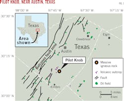
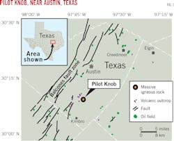
Pilot Knob is the eroded core of an extinct volcano 8 miles (13 km) south of central Austin, Tex., near Austin-Bergstrom International Airport and McKinney Falls State Park (Fig. 1). This area is 2 miles in diameter and encompasses four small, rounded hills including Pilot Knob proper.
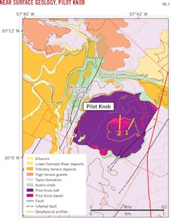
The hills are composed of relatively fine-grained tuff with isolated outcrops and subcrops of erosion-resistant, fine-grained, mafic volcanic rock, specifically basanite.1 Fig. 2 shows the most recent geological map of Pilot Knob, including geophysical profiles.2 Note that Profiles 1 and 2 cover volcanic tuff and solid basalt outcrops.
Uniform deposition of the Upper Cretaceous Austin Chalk was interrupted by volcanic activity in the ancient Gulf of Mexico. As a product of eruption, tuff mounds, formed by hydration of basaltic glass over eruption centers, controlled placement of shoal-water carbonates on topographic highs formed by volcanic processes.3 4
Palagonitization, the hydration of basaltic glass, altered the mounds of pyroclastic material accumulated around and over the volcanic centers after eruption. The topographic highs formed by the tuff mounds subsequently controlled localized deposition of shoal water carbonates. Isolated tuff mounds and associated shoal-water carbonates often suggest petroleum production is possible.
Geophysical work on Pilot Knob, which included the application of magnetic and gravity methods, was published as early as 1954.5 Gravity and magnetic data were collected along several traverses with station spacing of 0.5-1 mile. Results revealed strong gravity and magnetic anomalies over the central basalt mass and weaker anomalies caused by flows and dikes. They also concluded that serpentined pyroclastics show weak, negative anomalies.
Resistivity, magnetic surveys
Resistivity and magnetic data were collected along two profiles across the Pilot Knob extinct volcano in southeast Austin. Profile 1 was in the eastern part of Pilot Knob. Resistivity data show a series of anomalies, which could be due to a combination of a dike and a volcanic caldera. Magnetic data along the same profile show significant high and low magnetic anomalies, ranging between -3,500 and +4,500 nanoTesla (nT). The magnetic data also display significant fault anomalies, the sources of which are likely solid basalt masses and highly weathered volcanic rocks (palagonized).
This study measured the earth's magnetic field using a 10-Hz collection rate. A base station allowed the equipment to record daily variations and corrected the raw magnetic observations for data drift. This approach yielded high-resolution ground-based magnetic and resistivity surveys at the outcrops of Pilot Knob.
The 2D-resistivity method images the subsurface by applying a constant current to the ground through two electrodes and measuring the resulting voltage differences at two potential electrodes at a different site. Apparent resistivity is the product of the measured resistance and a geometric correction for a given electrode array. Resistivity values (Ω-m) are affected by several variables, including the presence of water or moisture, the amount and distribution of pore space in the material, and temperature. This array is sensitive to horizontal and vertical changes in the subsurface (compared to other arrays) and, when the data is inverted, provides a 2D electrical image of the near-surface geology. Electrode spacing was 10 and 15 ft along Profiles 1 and 2, respectively (Fig. 2).
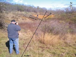
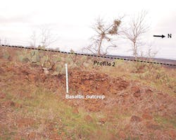
Profile 1 has a bearing of N40°E and crosses over a well-exposed tuff and volcanic lava contact (Fig. 5). Profile 2 trends north-south and extends over a basaltic outcrop on one of the hills of Pilot Knob (Fig. 6).
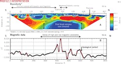
Profile 2 is about 1,000 ft west of Profile 1. Resistivity data show a sequence of layered volcanic rock, but they also show a well-defined low-resistivity unit in the center of the profile. This anomaly could be one of the volcanic cores of Pilot Knob.
Interpretation
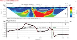
Figs. 3a and 3b show resistivity and magnetic data along Profile 1. Exploration depth of the resistivity data is about 131 ft in the middle of the profile. Resistivity values are 10-50 Ω-m, indicating a low-resistivity (high-conductivity) geo-electric section. Resistivity data show a dike-like anomaly between stations at 140 and 240 ft, displayed as a combination of low (blue) and high (red) resistivity values. A uniform, high-magnetic anomaly corresponds to the location of the resistivity anomaly (Fig. 3b). The magnitude of the magnetic anomaly is highest (4,000 nT) at the 180-ft station. This correlation suggests a solid basaltic mass for the origin of the resistivity and magnetic anomalies.
Resistivity data also show a crater-like anomaly between stations at 240 and 440 ft, 200 ft from the surface (red). This anomaly narrows to 80 ft at the bottom of the resistivity section. Its contact is sharply defined by the adjacent, lower-resistivity (blue and green) values. This high-resistivity anomaly is overlain by a low-resistivity layer as deep as 65 ft. Magnetic values over this anomaly drop as low as -1,000 nT (Figs. 3a and 3b). The source for these low magnetic and high-low resistivity values may be weakly magnetized, such as volcanic tuff, or palagonized volcanic rocks.
Magnetic data also display a fault-like anomaly on the station at 420 ft. Magnetic values drop to -3,000 from 500 nT across the fault and stay stable at 2,000 nT in the northeast direction for the rest of the profile (Fig. 3b). Resistivity data also show sharp contact between low and high-resistivity values.
Figs. 4a and 4b show resistivity and magnetic data along Profile 2. This profile is mostly within the Pilot Knob basalt shown on the geological map (Fig. 2). A topographic correction is applied to the resistivity data and minimum and maximum values are fixed as with Profile 1, which vary between 10 and 50 Ω-m. Resistivity data near the surface show a low-resistivity layer underlain by a high-resistivity layer, which thickens in the southern and northern sections of the profile (Fig. 4a). In the center of the profile, however, there is a significant low resistivity anomaly, sharply defined by all directions: top, north, and south. This anomaly is between stations at 280 and 600 ft and extends to a depth of 203 ft and more. The northern section of this anomaly is much steeper than the southern section (Fig. 4a). This anomaly is circular and its southern and northern boundaries dip steeply to the south the north, respectively.
A series of significant high and low-magnetic anomalies are observed along Profile 2. These anomalies range between 8,000 and -3,000 nT and correlate well with the location of the low-resistivity anomaly. This range suggests an origin of solid basalt masses and highly weathered volcanic material.
Survey results
One significant result from both profiles, especially Profile 2, is that the core of Pilot Knob, geologically mapped as solid basalt, consists of both strong and weak magnetic values. This separates the solid basalt from the weathered basalt, providing valuable information for oil and gas exploration.
The magnetic method has long helped detect buried volcanic rocks. Since resistivity surveys can be deployed to map subsurface as deep as 1,000-1,500 ft, additional resistivity surveys could offer useful information on the structure of volcanic and adjacent sedimentary rocks.
Acknowledgment
The authors would like to thank Brian Gieselman, Jeffrey Pender, Alfred Hawkins, and Alan Cherepon for their help in the field. Special thanks are due to Dr. Mark Helper for his permission to use the geological map of the Pilot Knob (Fig. 2) and Alan Cherepon for his reviewing the paper. This work was primarily funded by Environmental Geophysics Associates with additional support from the Barton Springs/Edwards Aquifer Conservation District in Austin. We also thank Exploration Instrument LLC, Austin, Tex., for providing the magnetometer.
References
1. Young K.P., Caran S.C., and Ewing T.E., "Cretaceous Volcanism in the Austin area, Texas," Austin Geological Society Guidebook No. 4, p. 66, 1982.
2. Caran C.S., Housh T., and Cherepon, A., "Volcanic Features of the Austin Area, Texas," Austin Geological Society Field Trip Guidebook 26, Spring 2006, p. 110.
3. Simmons, K., "A Primer on Serpentine Plugs in South Texas," South Texas Geological Bulletin, Vol. 7, No. 2, February 1967.
4. Matthews, T.F., "The Petroleum Potential of Serpentine Plugs and Associated Rocks, Central and South Texas," Baylor Geological Studies, Bull. 44, Fall 1986.
5. Romberg, F. and Barnes, V.E., "A Geological and Geophysical Study of Pilot Knob (South), Travis County, Texas," Geophysics, Vol. 19, No. 3, July 1954, pp. 38-454.
The authors
Mustafa Saribudak ([email protected]) is principal geophysicist-geologist at Environmental Geophysics Associates, Austin, Tex. He has also served as field manager at Tierra Environmental, Inc. He holds an MS in geological engineering from Istanbul University, Turkey, where he also earned his PhD in geophysics. He is a member of the Environmental Engineering Geophysical Society, the Austin Geological Society, and the South Texas Geological Society.
Christopher Caran ([email protected]) is a geologist with the Texas Water Development Board, Austin, Tex. He has also served as a geologist and lecturer at the University of Texas at Austin, Jackson School of Geosciences. He holds BS and MA degrees from the University of Texas at Austin. He is a member of the Geological Society of America and the Austin Geological Society.
