Vast resource estimated in UK's Bowland-Hodder shale
The following is the summary from the recent assessment by the British Geological Survey and UK Department of Energy and Climate Change of gas in place in the Bowland-Hodder shale in the central UK onshore (OGJ Online, June 27, 2013).
Assessment of shale gas resources in the UK is in its infancy. This report summarizes the background geological knowledge and methodology which has enabled a preliminary in-place gas resource calculation to be undertaken for the Bowland-Hodder (Carboniferous) shale gas play across a large area of central Britain.
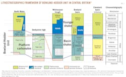
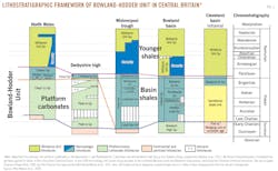
The Bowland-Hodder shale gas play is the term used in this report for an amalgamation of shales of Visean to early Namurian age that includes the Bowland shale formation and its equivalents together with older shales which equate to the Hodder mudstone formation (Fig. 1).
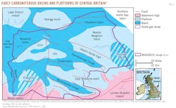
Marine shales were deposited in a complex series of tectonically active basins across central Britain during the Visean and Namurian epochs of the Carboniferous 347-318 million years ago. In all of these basins, deepwater marine shales pass laterally into shallow-water shelf limestones and deltaic sandstones. Contemporary basins extend offshore beneath the East Irish Sea and the southern North Sea.
The marine shales attain thicknesses of up to 16,000 ft (5,000 m) in basin depocenters (i.e., the Bowland, Blacon, Gainsborough, Widmerpool, Edale, and Cleveland basins), and they contain sufficient organic matter to generate considerable amounts of hydrocarbons (Fig. 2). Conventional oil and gas fields around most of these basins attest to their capability to produce hydrocarbons.
The organic content of the Bowland-Hodder shales is typically in the range of 1-3% but can reach 8%.
The maturity of the Bowland-Hodder shales is a function of burial depth, heat flow, and time, but subsequent uplift complicates this analysis. Where they have been buried to sufficient depth for the organic material to generate gas, the Bowland-Hodder shales have the potential to form a shale gas resource analogous to the producing shale gas provinces of North America (e.g. Barnett shale, Marcellus shale). Where the shales have been less-deeply buried, there is potential for a shale oil resource (but, as yet, there is inadequate geotechnical data to estimate the amount of oil in place).
In this study, shales are considered mature for gas generation (vitrinite reflectance >1.1%) at depths greater than c. 9,500 ft (2,900 m) (where there has been minimal uplift). However, central Britain has experienced a complex tectonic history and the rocks here have been uplifted and partially eroded at least once since Carboniferous times. Because of this, the present-day depth to the top of the gas window is dependent on the amount of uplift, and can occur significantly shallower than 9,500 ft.
The total volume of potentially productive shale in central Britain was estimated using a 3D geological model generated using seismic mapping, integrated with outcrop and deep borehole information. This volume was truncated upwards at a depth of 5,000 ft (1,500 m) below land surface (a suggested US upper limit for thermogenic shale gas production) or the depth at which the shale is mature for gas generation (whichever was the shallowest).
The volume of potentially productive shale gas was used as one of the input parameters for a statistical calculation (using a Monte Carlo simulation) of the in-place gas resource.
For the purposes of resource estimation, the Bowland-Hodder unit is divided into two units: an upper postrift unit in which laterally contiguous, organic-rich, condensed zones can be mapped, even over the platform highs, and an underlying synrift unit, expanding to thousands of feet thick in fault-bounded basins, where the shale is interbedded with mass flow clastic sediments and redeposited carbonates.
The upper unit is more prospective, primarily due to the better well control which demonstrates its closer resemblance to the prolific North American shale gas plays, in which the productive zones are hundreds of feet thick. The lower unit is largely undrilled, but where it has been penetrated it contains organic-rich shale intervals whose lateral extent is unknown.
This study offers a range of total in-place gas resource estimates for the upper Bowland-Hodder unit shales across central Britain of 164-264-447 tcf (4.6-7.5-12.7 tcm) (P90-P50-P10). It should be emphasized that these ‘gas-in-place' figures refer to an estimate for the entire volume of gas contained in the rock formation, not how much can be recovered.
There is considerable upside potential in the lower unit, but the resource estimation for this unit has a much higher uncertainty due to the paucity of well data so far and potentially less favorable lithologies. The estimated range of gas in place for this thick unit is 650-1,065-1,834 tcf (18.7-31.2-51.9 tcm). The estimated range of gas in place for this thick unit is 658-1,065-1,834 tcf (18.7-31.2-51.9 tcm). The total range for estimated gas in place is 822-1,329-2,281 tcf (23.3-37.6-64.6 tcm) for the combined upper and lower parts of the Bowland-Hodder unit.
This large volume of gas has been identified in the shales beneath central Britain, but not enough is yet known to estimate a recovery factor nor to estimate potential reserves. An estimate was made in the previous DECC-commissioned 2010 BGS report that the Carboniferous Upper Bowland shale, if equivalent to the Barnett shale of Texas, could potentially yield up to 4.7 tcf (133 bcm) of shale gas. In the absence of subsurface volumes of potential gas-bearing shale, this early estimate was based on the relative areal extent of the basins.
Now, after detaild subsurface analysis, a "bottom-up" resource assessment of gas in place has been made, which more accurately reflects the area's shale gas potential. However, it is still too early to use a more refined methodology, like the US Geological Survey's technically recoverable resource "top-down" estimates which require production data from wells.
In time, the drilling and testing of new wells will give an understanding of achievable, sustained production rates. These, combined with other nongeological factors such as gas price, operating costs, and the scale of development agreed by the local planning system, will allow estimates of the UK's shale gas reserves to be made.
Other areas in the UK have shale gas and shale oil potential, and later in 2013 the Jurassic shales in the Weald basin of southern England will be the subject of a further BGS/DECC study.


