Argentina's Alvear subbasin may have unconventional oil
Juan Carlos Pucci
Consulting geologist
Buenos Aires
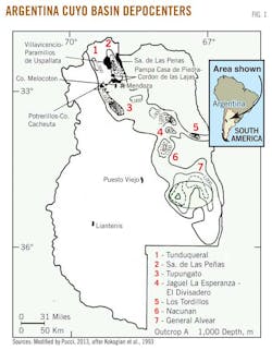
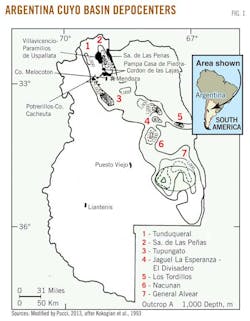
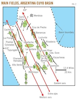
Oil fields in Argentina's Cuyo basin, lying just north of the Neuquen basin, are concentrated in only about 5% of the basin's total areal extent of 42,640 sq km (Figs. 1 and 2).
Commercial production in the Cuyo-Cacheuta basin began in 1932 with the Cacheuta-1 oil discovery well. However, since 1877 asphalt outcrops were exploited for domestic use.
The Cacheuta subbasin is well known due to extensive exploration carried out by Yacimientos Petroliferos Fiscales and private companies.
This article is a detailed discussion of the Alvear subbasin with an eye to the potential for unconventional hydrocarbons, which can be found at drilling depths of 1,000-2,300 m.
At present no company holds a license to explore for hydrocarbons in unconventional formations in the Alvear subbasin. Licenses are granted by and may be proposed to the provincial authorities.
Since the dawn of exploration in the Cuyo basin, 414 wildcat wells have been drilled and seismic acquisition totals 20,727 line-km of 2D and 2,704 sq km of 3D.
Much information is available at the office of the secretary of energy of Mendoza Province, but more data such as lithological descriptions and well reports are necessary for a better assessment.
As of December 2011, Cuyo proved reserves were 33,057 million cu m of oil and 715 million cu m of natural gas. As of 2012, cumulative oil production was 195,772,226 cu m.1
Cuyo geology
The evolution of the Triassic-Cretaceous Cuyo basin, located in the Precordillera of Western Argentina, was mainly controlled by extensional-transtensional tectonics along northwest-trending structures inherited from Paleozoic sutures, revitalized during the Cenozoic as a foreland basin due to the Andean orogeny current responsible for the structural configuration.
The Cuyo basin comprises several subbasins or depocenters ranging in depth from 1,000 m to more than 4,000 m (Fig. 1).
The Cacheuta-Tupungato depocenter is the only area with oil production.
The Cuyo basin is elongated in a NNW-SSE direction and has a taphrogenic origin.
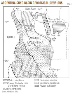
The western limit corresponds to two significant orographic systems: the Precordillera and the Frontal Cordillera. To the southwest it is bounded by the Sierra Pintada system which separates the Cuyo basin from the Mesozoic Neuquen-South Mendoza basin The eastern boundary includes metamorphics and igneous rocks (Paleozoic and Proterozoic) of the Pampean ranges and Permotriassic volcanic rocks of the Sierra Pintada Group (Choiyoi group). To the north Triassic sediments exceed the boundaries of Mendoza Province and are exposed in a huge sector of the precordillera of the San Juan Province (Fig. 3)
The origin, stratigraphy, distribution, and sedimentary environment of each of the formations have been subject to an analysis in several published works in the last decade.2 3 Since detailed discussion of stratigraphy is not the main purpose of this article, interested readers are referred to those works. Here only aspects fundamental to understanding the Alvear subbasin's exploration potential are discussed.
The Cacheuta and Alvear subbasins are mainly subsurface features in which most of the formations found in the subsurface of the Cuyo basin were originally defined from outcrops in the mountains west of Mendoza city.
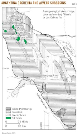
The Cacheuta is one of these subbasins, which, in the paleogeological sketch map appears connected to the Alvear subbasin (Fig. 4). This connection apparently existed at the beginning of Triassic times, but the precise origins of communication in some sectors seem to have existed in uplifted areas of pre-Triassic units that served as early separation and supply areas.
The separation between the Cacheuta and Alvear subbasins is due to an original paleohigh or dorsal feature at about 34° S. Lat. This high, known as the Rio Diamante dorsal, is located in close combination with the current course of the Diamante River.
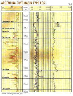
The stratigraphic column of the Cuyo basin in the Cacheuta-Tupungato depocenter mainly consists of Paleozoic rocks and a Permian-Triassic volcanicclastics complex. The overlying units are composed primarily by Triassic continental sediments and also Jurassic-Cretaceous and Lower Tertiary nonmarine and volcanic rocks (Figs. 5 and 6).
The Triassic section from base to top is made up of the Rio Mendoza, Las Cabras, Potrerillos, Cacheuta, and Rio Blanco formations.
The lowermost Rio Mendoza formation unconformably overlies volcanic and volcaniclastic deposits of the Choiyoi Group.
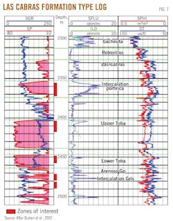
The overlying Las Cabras formation is a thick unit (Fig. 7). Its lower part is a mudrich succession with intercalated lenticular bodies of conglomerates and pebbly sandstones. The upper section is a fine-grained succession composed of multicolored mudstones, tuffs, and pyroclastic siltstones.
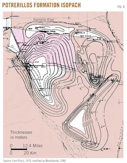
The Potrerillos formation is the thickest Triassic unit and is characterized by cyclic alternations of gravel-, sand-, and mudrich intervals (Fig. 8).
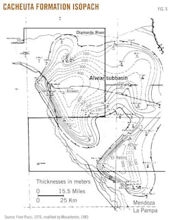
These deposits are followed by a succession of black shales of the Cacheuta formation (Fig. 9).
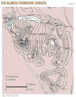
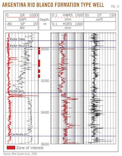
The Triassic succession ends with the red beds of the Rio Blanco formation composed of fluvial and lacustrine sediments (Figs. 10 and 11).
With the deposition of the Rio Blanco formation, the Triassic sequence acquired its maximum extent. In addition, the communication between the Cacheuta and Alvear subbasins was restarted. This communication was made mainly from the northwest of the Alvear subbasin, as evidenced by YPF´s Estacion Monte Coman-1 and Alvear West-1 wells.
In the Cacheuta subbasin two anticlinal axes oriented NNW contain the most characteristic surface features (Fig. 2). They are the western and the eastern axes.
Fields in the western axis contain 12% of the oil production while 88% is from eastern axis fields.
Source rocks
Geochemical analyses recognized only two source rocks in the Cuyo basin.2 3 4 5 6
The major proven source rock corresponds to the entire Cacheuta formation (Fig. 9) and the upper third of the Potrerillos formation (Fig. 8). The other corresponds to the bituminous pelites from the informally named "intercalacion gris" (grey intercalation) in the Las Cabras formation.
More than 60 wells and a dozen outcrop sections corresponding to the upper third of the Potrerillos formation and the entire Cacheuta formation were analyzed to obtain total organic carbon values.
Analysis of subsurface samples showed average TOC values of 4 wt %. Maximum values varied from 5 wt % for proximal positions to 12% in distal positions of the basin.6 7
TOC values of 0.2-0.9% were found in the Rio Blanco formation (Fig. 11). While this last magnitude is appealing, the inertinite found on these levels reduces the possibility of hydrocarbon generation. Regarding the "intercalacion gris" (grey intercalation) of the Las Cabras formation (Fig. 7), its TOC value is known only by Strelkov and Alvarez.8 Analytic-quantitative studies are also unknown.
In most cases, the amount of organic matter present in the previous column varies in the developing of the sedimentary Las Cabras and Potrerillos formations. Maximum TOC values were established in packages corresponding to lagoons or ephemeral inundations. TOC values are strongly relevant and continuous where they contact with lacustrine deposits of the Cacheuta formation and rapidly decrease when measurements are taken on fluviatile levels of the Rio Blanco formation.
It was possible to define with certainty that the lacustrine pelites interbedded in the upper third of the Potrerillos formation and the thick packages of black shales of the Cacheuta formation, have Type I kerogen, i.e., basically, algal material.
The Potrerillos-Cacheuta column exhibits a gradual enrichment of Type I kerogen towards the top of that sequence, while there is an occasional presence of Type II (in middle levels) and insignificant occurrence of some shows of Type III (at the base). This distribution of the types of organic matter is consistent with the depositional system responsible for such units, as it passes from base to top, from a definitely river system to terms that reflect the inundation of the basin with lacustrine pelitic packages.7
The bituminous pelite located in the Las Cabras formation as potential source rock is more uncertain (Fig. 7). Indeed, few wells have drilled through the intervals and provided samples for geochemical analysis. However, some correlation with the "grey intercalation" is exposed in outcrops of the Las Cabras.
Geochemical studies on samples indicated that the rocks are potential sources for hydrocarbons due to high organic content and to organic richness in saturated and aromatic hydrocarbons. It is unknown if studies on this unit have been continued or developed.
In the Rio Blanco formation, the type of this organic matter is limited to Type III kerogen, with a predominance of inertinite that, usually, corresponds to the second cycle of organic matter, in consistency with the fluviatile system that represents this unit.
Maturity of organic matter was determined by the Thermal Alteration Index (TAI) and vitrinite reflectance. The Cacheuta formation revealed a maturity close to the initial generation of hydrocarbon liquids. Maturity in the west of Cacheuta and Tupungato, most high, is linked with a maximum of generation of oil. More favorable maturity for the generation is measured at deeper levels, corresponding to the upper third of the Potrerillos formation.
The processes of hydrocarbon generation, migration, and accumulation were triggered and controlled by the development of a Tertiary foreland basin that overlapped the Cuyo basin, providing the sedimentary column necessary for source rock maturation during the last 10 million years until the present.
Moderate mature oils (VRE ~0.7-0.9%) were sourced from the Tupungato kitchen to feed the reservoirs of the Eje Oriental (Eastern axis) district, after a long-distance lateral migration from the southeast towards the east through the Barrancas carriers. The Punta de las Bardas formation acted as an excellent quality regional seal. The contour area of Entre Ejes-Rio Hondo to the east sourced early oils (VRE ~0.55-0.7%) that were mostly trapped locally.
Jones et al.6 defined five petroleum systems in the Cacheuta subbasin3 from a single generator level and five reservoir levels.
In the Tupungato area (Fig. 1) source rocks reach the oil generation window approximately at 12 million years while the deepest levels would fall in late phase after 2 million years. However to the opposite east side, the Rivadavia zone continues immature at present, mainly due to the lower Tertiary subsidence, and left from the Andean front of deformation. The "between axis" area (Entre Ejes area) reaches the generation window at approximately 1 million years.
To date, the analysis of migration paths has been tentative based on geochemical correlation of maturity and facies of oil-source rocks.6 9 Until now no publication or modeling has shown how and when the hydrocarbons generated in the Tupungato depocenter arrived to traps and reservoirs located in the eastern axis of the basin.
It should be noted that in the Cuyo basin, almost 88% of the total production of hydrocarbons is yielded on the eastern axis (Fig. 2), however the older source rock thicknesses and conditions of generation and expulsion occurred in the western axis. This might be an indication of lateral migration of 20-70 km.
The Triassic and Jurassic units (Barrancas formation) involved in the migration of hydrocarbons are composed of fluvial, braided, meandering, and ephemeral deposits.7 From the point of view of the primary porosity the main carrier are the clastic rocks of the Barrancas formation and subordinated by the Rio Blanco formation.
In the Cuyo basin is recognized an important network of subvertical fractures of different magnitude, possibly a reactivation of older deeper faults, that would provide excellent migration paths (Figs. 12 and 13).
The reservoirs correspond to rocks of continental origin; those with better petrophysical conditions correspond to the fluvial sandstones of the Barrancas (Jurassic) and Papagayos (Cretaceous) formations.
The rest of the accumulations are clastic fluviodeltaic deposits and volcaniclastic of the Triassic Rio Blanco, Potrerillos, and Las Cabras formations Minor accumulations are included in the eolian deposits of the Areniscas Entrecruzadas member (Marino formation) of Tertiary age and the deep sea levels of the Villavicencio formation (Devonian).
A detailed description of the exploratory plays of the Cuyo (Cacheuta) basin, associated to the Cacheuta Barrancas(!) oil system as to various hypothetical and speculative systems, can be found in Boggetti et al, 2005.10
General Alvear subbasin
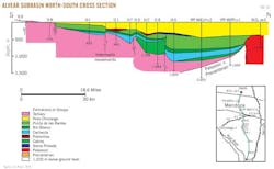
The stratigraphic column of the Alvear depocenter (Fig. 14), although similar to the Cacheuta-Tupungato, is abridged.
The lower layers are common to the Sierra Pintada hills located to the west.11 The Precambrian consists of the La Ventana formation whose levels, which were drilled by few exploration wells, are made up of granatiferous and micaceous schist rocks. In a sample recovered from the Gulf IV-D well, the radiometric age was found to be 605 million years.
The Cambro-Ordovician Pilches formation, which consists of sandstones, limestone, and shales are affected by gentle metamorphism.11
The formation is only a subsurface unit, penetrated by the SAOC/IV/B well, and the radiometric dating yielded values of 441 million and 534 million years.
The overlying unit is the carboniferous Imperial formation, whose levels are widely distributed in outcrops of the Sierra Pintada hills and were penetrated in several wells in the depocenter. Essentially, the lithology consists of clayey and conglomeratic reddish and yellowish sandstone with shaly and limolithic intercalations.
The carboniferous sediments are overlaid volcanic rocks with some tuffs and few sediments whose conspicuous representatives are very well exposed in the Sanrafaelino-Pampeana geological province (Fig. 3), from where derives its identification as the Sierra Pintada Group.
Radiometric dating showed values between 200 million and 270 million years indicating a Permo-Triassic age.
Exploratory results
The results of intense exploratory activity, through reflection seismic surveys and the drilling of 51 wells, allow formation of a somewhat optimistic picture regarding the depocenter prospectivity.
Several exploration areas were awarded to Gulf Oil, Esso, and YPF.
Exploration began in the late 1960s, and as a result of exploratory commitments companies recorded almost 4,000 line-km of reflection seismic and drilled 50 wells (22 by YPF, 26 by Gulf, and 2 by Esso). This stage was completed in 1972.
After 20 years with no activity, within the framework of the exploratory "Plan Argentina," the General Alvear block was awarded in 1992 to the consortium comprising Tecpetrol SA and Shell CAPSA. The two companies recorded 800 line-km of 2D seismic and drilled Tp.Mz B x-1, the last well drilled in the Alvear subbasin.
Since the beginning of the exploration it was considered that the dark gray and black shales of the Cacheuta formation (Fig. 9) are the real source rocks, as in the depocenter located to the north.
However, in the Alvear subbasin the amount of organic matter, measured in terms of TOC, is similar to that in the Cacheuta subbasin. The same occurs with the quality or type of organic matter, mainly consisting of algaceous and amorphous material (Type I), with subordinate proportions of Type II herbaceous and woody material.
Therefore, it would fully meet with two of the basic concepts to consider an adequate rich-organic-matter rock. Unfortunately, the exploration carried out by wildcat wells and the analytical work performed on the material recovered from wells, indicate with a high degree of certainty that the evolution or maturity of the organic matter contained in its sediments did not pass all stages that could establish the Cacheuta formation as a source rock for this region.
After the deposition of the Triassic sediments, possibly due to the uplift of the San Rafael block, the region remained a high and stable area for long periods. This implied a relatively low rate of post-Triassic sedimentation, with the reduction of the thickness of the rocks overlying the Cacheuta formation.
The second negative element is the very low or almost zero tectonic influence of this sector of the basin during the tertiary compressive movements of the Andean tectonic. Nevertheless, horizontal displacements occurred, related to the fracture system and its relative movement that affected the different taphrogenic phases.
Both factors, coupled, lead to a common result which is the insufficient lithostatic load and temperatures to make possible the development of organic matter to hydrocarbons in sufficient quantity to produce commercial accumulations.
Analyzing the results of exploratory wells drilled in the depocenter, it appears that only this package of sediments is a potential source rock of the region, at least at the regional level.
The exception is some reduced sector in which the quality of organic matter reaches the "window" of liquid hydrocarbon generation, as verified by the production test of the Ituzaingo x-2 well that yielded 22.2 cu m of oil at levels corresponding to the Potrerillos formation (Fig. 8). Three more wells drilled in the vicinity could not confirm the occurrence of hydrocarbons.
The critical factor is the low level of maturity of the pelites of Cacheuta, regardless of their high TOC values and the type of the organic matter present.
Hydrocarbon potential
The information provided by the recording of 4,800 line-km of 2D seismic and drilling 51 exploratory wells in the Alvear subbasin allows us to conclude that there are good structural and stratigraphic conditions for the entrapment of hydrocarbons.
In the folding structures, structural closures against faults, good reservoirs and seal rocks are recognized.
The fundamental structural characteristics of the area consist of a series of blocks delimited by fractures (Figs. 8 and 9) with near-vertical inclinations. Such fractures show signs of differential movement. Few defined structures have been generated by these blocks, not existing in the zone certain evidence of compression movements.
As shown in the cross-sections (Figs. 12 and 13), the different fractures have been reactivated in different periods, in a game of rise and fall of blocks, showing clear evidence of inversion relief, in relation to different cycles. This fact is very noteworthy, among the pre- and postcabras movements, as it also occurs in the Cacheuta subbasin.
However, the results thus far have been discouraging, considered for the oil possibilities of the depocenter.
The critical factor, from the point of view of the hydrocarbon potential of the depocenter, is the low maturity level of the pelites of the Cacheuta.12
The black and dark gray shales of the Cacheuta formation have organic matter in proper quality and quantity to generate hydrocarbons, but its maturity is not sufficient. The lithostatic load and the temperatures did not reach the values to enable the evolution of organic matter to hydrocarbons, as to produce commercial accumulations.12
Organic material begins to appear in the gray portion of the Rio Blanco and becomes increasingly abundant with depth. In some wells thin black shale zones similar to the underlying Cacheuta formation, have been seen well above the base of the Rio Blanco. In the north there is a sharp contrast between the gray basal Rio Blanco and the very bituminous black shales of the Cacheuta formation.
This lithologic contrast disappears farther to the south as the Cacheuta formation is less bituminous. In the northern part of the Alvear subbasin and in the Cacheuta subbasin the black shale facies extends up into the lower Rio Blanco so the basal contact is gradational. A proposal has been made to place the lower Rio Blanco (Victor Gris) in the Cacheuta formation.
Within most of the subbasin there are few sandstone lenses within the Rio Blanco, and these are generally thin and discontinuous. The only sand that appears to extend over a relatively large area is a 15-30 m thick basal lens that is present in the Nandu and Chimango wells and as far as M/GA/x-1 (Gen. Alvear) well. YPF's M/GA/x-2 well, near the western margin of the basin, has an unusual number of well-developed sand lenses in the Lower Rio Blanco.
The sandstones are loosely consolidated, generally quartzose, and vary from fine to very coarse grained. They are usually very argillaceous and, although logs indicate porosities varying from 20 to 30%, visual examination of sidewall cores suggests that effective porosity and permeability are low.
Depending on the quantity and quality of information available (seismic and wells) the Alvear subbasin would not be a true exploration frontier area. However, it is necessary to remark that there are elements of the oil system that cannot be explained with the current hypothesis.
The occurrence of oil in the Potrerillos formation (Fig. 8), even in noncommercial quantities, shows different exploratory alternatives. Among them are areas of thermal anomalies associated with Cretaceous or recent volcanism enabling the generation in localized areas or migration over long distances by presently unknown carrier beds.
References
1. Pucci, J.C., "Cuyo basin, in Argentina's basins with unconventional methods plays," report in progress.
2. Kokogian, D., and Mancilla, O., "Analisis estratigrafico secuencial de la Cuenca Cuyana--Secuencias deposicionales continentales," in Chebli, G.A., and Spalletti, L.A., eds., "Cuencas Sedimentarias Argentinas," Serie de Correlacion Geologica 6 (San Miguel de Tucuman), 1989, pp. 169-201.
3. Kokogian, D.A., Fernandez Seveso, F., and Mosquera, A., "Las secuencias sedimentarias Triasicas," in Ramos, V.A., ed., "Geologia y recursos naturales de Mendoza," XII Congreso Geologico Argentino y II Congreso de Exploracion de Hidrocarburos, Relatorio I, Vol. 7, 1993, pp. 65-78.
4. Villar, H., and Puttmann, W., "Geochemical characteristics of crude oils from the Cuyo basin," in Durand, B., and Behar, F., eds., "Advances in organic geochemistry," Organic Geochemistry, Pergamon Press, Vol. 16, 1989, pp. 511-519.
5. Dellape, D., and Hegedus, A., "Structural inversion and oil occurrence in the Cuyo basin in Argentina," in Tankard, A., Suarez, R., and Welsink, H.J., eds., "Petroleum basins of South America, AAPG Memoir 62 1995, pp. 359-367.
6. Jones, D., Kokogian, D, Barzola, G., and Ortiz, A., "Sistemas petroleros de la Cuenca Cuyana," IV Congreso de Exploracion y Desarrollo de Hidrocarburos, IAPG, Actas I, 1999, pp. 127-143.
7. Chebli, G., Labayen, I, Lafitte, G., and Rosso, M. del R., "Materia organica, ambiente deposicional y evaluacion oleogenetica de la Cuenca Cuyana," IX Congreso Geologico Argentino, Buenos Aires, Actas VII, 1984, pp. 68-85.
8. Strelkov and Alvarez, "La intercalacion gris de la formacion Las Cabras," YPF unpublished report, 1983.
9. Figueroa, D., and Chebli, G., "Migracion y entrampamiento de hidrocarburos en la Cuenca Cuyana, Argentina," X Congreso Geologico Argentino (San Miguel de Tucuman), Actas II, 1987, pp. 285-288.
10. Boggetti, D., Ibanez, G., Kokogian, D., and Villaroel, H., "Cuenca Triasica de Cuyo in Frontera Exploratoria de la Argentina," Chebli, D., et al., eds., VI Congreso de Exploracion y Desarrollo de Hidrocarburos, 2005.
11. Pucci, J.C., "Contribucion al conocimiento del subsuelo de General Alvear (provincia de Mendoza) y regiones adyacentes," University of Buenos Aires, unpublished PhD thesis, 1976.
12. Chebli, G.A., Ploszkiewicz, J.V., and Azpiroz, G.M., "El Sistema Triasico y los hidrocarburos," in Artabe, A.E., Morel, E.M., and Zamuner, A.B., eds., "El Sistema Triasico en la Argentina," Fundacion Museo de La Plata 'Francisco Pascasio Moreno,' La Plata, 2001, pp. 283-315.
Bibliography
Criado Roque, P., "Subcuenca de Alvear (Provincia de Mendoza)," Segundo Simposio de Geologia Regional Argentina, Vol. I, Cordoba, Argentina, 1979, pp. 811-836.
Kokogian, D.A., Spalletti, L.A., Morel, E.A., Artabe, A.E., Martinez, A.E., Alcober, O.A., Milana, J.P., and Zavatieri, A.M., "Estratigrafia del Triasico Argentino," in Artabe, A.E., Morel, E.M., and Samuner, A.B., eds., "El Sistema Triasico en la Argentina," Fundacion Museo de La Plata "Francisco Pascasio Moreno," La Plata, 2001, pp. 23-54.
Kozlowski, E., Manceda, R., and Ramos, V.A., "Estructura," in Ramos, V.A., ed., "Geologia y recursos naturales de Mendoza. XII Congreso Geologico Argentino y II Congreso de Exploracion de Hidrocarburos, Buenos Aires, 1993, Relatorio I, Vol. 18, pp. 235-256.
Legarreta, L., and Villar, H.J., "Geological and geochemical keys of the potential shale resources, Argentina basins," in "Unconventional Resources: Basics, Challenges and Opportunities for New Frontier Plays," AAPG Geoscience Technology Workshop, June 26-28, 2011, Buenos Aires.
Monasterolo, E., and Giudici, A., "Estado y perspectivas exploratorias de la subcuenca de General Alvear, Provincia de Mendoza," YPF unpublished report, 1980.
Rolleri, E. and Garrasino, C. Fernandez, "Comarca septentrional de Mendoza," Segundo Simposio de Geologia Regional Argentina,Cordoba, Argentina, 1979, Vol. I, pp. 771-809.
Rosso, M., Labayen, I., Laffitte, G., and Arguijo, M., "La generacion de hidrocarburos en la Cuenca Cuyana, Argentina," X Congreso Geologico Argentino, Actas II, 1987, pp. 267-270.
Scolari, Juan C., Ayala, Marcelo, Regazzoni, Carin Regazzoni, and Boggetti, D., "Los reservorios de la Formacion Las Cabras," in "Rocas reservorios de las cuencas productivas de la Argentina," V Congreso de Exploracion de Hidrocarburos, 2002, pp. 617-624.
The author
Juan Carlos Pucci ([email protected]) has been active in international exploration for 35 years and has experience in exploration and frontier basins onshore and offshore in South America. His employers have included GSI, Cities Service, and Mobil Oil. He was the geologist who represented Argentina's secretary of energy in privatization of the country's upstream sector. At present, he is an exploration advisor with Crescent Global Oil, Addison, Tex. He has an MS in petroleum geology and a PhD in geology from the University of Buenos Aires.
