Applying gamma-ray logs to a carbonate reservoir: a Pakistan Potwar basin example
M. Younis Khan
University of Peshawar
Peshawar, Pakistan
M. Gulraiz Akhter Zulfiqar Ahmad
Quaid-i-Azam University
Islamabad
Reservoir rocks (carbonates and sands) are mainly sedimentary in nature with interconnected pore spaces (permeability), reflecting the ease with which hydrocarbons can flow in the rock, but the presence of clay minerals or shale in reservoir rocks creates problems while interpreting well logs.
Very small amounts of shale can have a large effect on both key petrophysical properties (porosity and permeability). Most reservoirs contain some degree of shaliness; therefore one must identify the distribution of clay minerals to understand its effect on the reservoir quality of shaly carbonates.
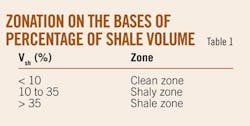
With the help of a gamma-ray log, the percentage of shale volume (%Vsh) is calculated as this log is widely used for the forementioned purpose. On the basis of %Vsh, three different zones are identified, namely a clean zone (<10% Vsh), a shaly zone (10-35% Vsh), and a shale (>35% Vsh). Identifying these zones improved reservoir characterization by investigating the target reservoir interval (pure carbonates) associated with corresponding depositional environment and stratigraphic boundaries.
Introduction
In order to demarcate the changes within the same stratigraphic unit, a formation is divided into different zones in such a manner that each zone is distinctive from another. Section boundaries in formations confirm the limits of zones which are significant from a hydrocarbon exploration point of view, especially in the case of conventional reservoirs.
There are several approaches applied to address the problem; e.g., identification of sudden variations in statistical variance,1 in the mean developed by Webster,2 and mathematical analysis of well log trends.3 Asquith and Gibson4 related the grain sizes with bulk volume of water, and Chikhi et al.5 discussed hybrid neural networks. All above mentioned techniques need intense computer analysis and programming.
In this article the main focus is put into the identification of certain segments reflecting geologically meaningful zones based on single and most commonly available gamma-ray log in water as well as hydrocarbon exploratory wells through cross-plotting shale volume against depth using simple and established mathematical relationship presented by Dresser Atlas.6
Geological and stratigraphic framework
According to Kemal,7 Pakistan possesses the northwestern boundary of the Indian lithospheric plate, a part of which is called the Indus basin.
The basin comprises 533,500 sq km and contains more than 15,000 m of sediments, ranging in age from Precambrian to recent, and is deformed by Indian and Eurasian plate collision. The basin is comprised of buried ridges, platform slope, and a zone of upwarp and downwarp.8
The Indus basin elements are broadly classified as, in the Upper Indus basin, the Kohat and Potwar subbasins, and in the Lower Indus basin, the central and southern subbasins.
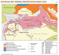
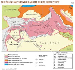
The Potwar subbasin is in the western foothills of the Himalayas in northern Punjab, bounded by 32° and 34° N. Lat. and 70° and 74° E. Long. (Fig. 1). Potwar, in which the first commercial discovery was made in 1914 at Khaur, is one of the globe's oldest oil provinces. So far, about 150 exploratory wells have been drilled there.9
Meyal oil field is one of the major oil and gas producing fields in the subbasin, discovered by Pakistan Oil Fields Ltd., in 1968. Meyal has 16 wells that have produced more than 36 million bbl of oil and 250 bcf of gas from fractured shallow marine shelf deposits with most prolific reservoirs in carbonates of the early Eocene age Chorgali-Sakesar formation.10
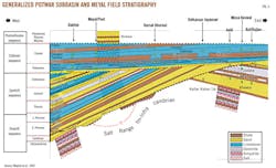
According to Moghal,9 the Potwar subbasin is filled with thick Precambrian evaporates overlain by relatively thin platform deposits of Cambrian to Eocene age followed by thick Miocene Pliocene molasse (Fig. 2). This whole section has been deformed by intensive Himalayan orogeny in Pliocene to Middle Pleistocene.
The main purpose of this work is to characterize a shaly formation (carbonate reservoir) by applying a segmentation approach based on the GR log, which is usually available during hydrocarbon exploration studies. The secondary objectives include whether the zonation technique helps in understanding depositional environment and marking stratigraphic boundaries.
Materials and methods
Although many geophysical logs (gamma-ray, resistivity, and density-neutron logs) are utilized to calculate the shale volume,12 for the present study the gamma-ray log is used.
This log is used because it is one of the best tools for identifying and determining the volume of shale because of its sensitivity to the radioactive materials that are usually concentrated in shaly rocks.
The shale volume (Vsh) can be calculated from the gamma-ray index, by using the relation6 and expressed as a decimal fraction or percentage using the equation
Vsh = 0.33 [2^ (2*IGR) - 1.0]
where IGR = (GRlog – GRmin)/(GRmax – GRmin) and IGR is the gamma-ray index, GRlog is the gamma-ray reading for each zone, and GRmin and GRmax are the minimum gamma-ray value (clean sand or carbonate) and the maximum gamma-ray value (shale).
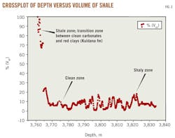
Different zones (clean, shaly, and shale zones) are identified (Fig. 3) on the basis of percentage of volume of shale as per criteria described by Ghorab13 and shown in Table 1.
Results and discussion
Two well logs, MYL-1 and MYL-2, from Meyal oil field were analyzed in the target (Chorgali) interval.
Well log interpretation of MYL-1
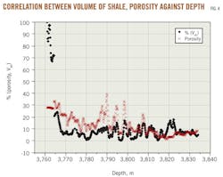
The Chorgali formation clean zone (3,770-90 m) containing Vsh < 10% is distinguished clearly from the shale zone (3,760-66 m) with Vsh > 35% on basis of volume of shale percentage.
The shale zone also marks a sharp stratigraphic boundary between the Kuldana formation having a thickness of 55 m with high GR characteristics and the underlying Chorgali limestone. The shaly zone is identified at approximately 3,818-24 m (Fig. 3).
Porosity is the ratio of the volume of voids to the total volume of rock. The presence of clay complicates the definition of reservoir porosity.
In the zone at 3,770-90 m the volume of shale is comparatively less as evident from Fig. 4 indicates an increase in the porosity (> 20%) at depth of 3,790 m in the Chorgali reservoir reflecting rock texture with the corresponding depositional environment (course grained rock with high porosity was deposited in high energy environment which lacks clay material).
Well log interpretation of MYL-2
The same methodology is applied to MYL-2 to determine shale volume for zonation of the Chorgali formation.
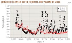
This well confirmed the boundary at depth of 3,732 m between two formations (Kuldana and Chorgali) having different gamma ray signatures. The pure carbonate section identified in the interval 3,750-60 m, while the shale zone is in the range of approximately 3,730-35 m. The deeper part of the Chorgali showed a relatively thick shaly zone which was observed in MYL-1, extending from 3,760 m to 3,790 m (Fig. 5).
Petrophysical interpretation of both Meyal field wells showed that the Chorgali formation consists of three main zones (clean, shaly, and shale) distinct from each other. All three zones are clearly identified on basis of shale volume.
The clean zone having small amount of clay content is the most important section for hydrocarbon exploratory work as it shows pure carbonates with no complexity in porosity or permeability due to the absence of clay minerals and limestone as dominant lithology.
The shale zone is characterized by a very high amount of shale volume (>35 Vsh %), probably reflecting a high concentration of radioactive minerals such as uranium and thorium. Besides these maxima and minima, an intermediate zone called the shaly zone showed moderate values of shale and mud and the presence of impure carbonates.
The segmentation helped in marking the reservoir interval and characterizing the depositional environment based on varying clay content over two studied sites utilizing single wireline log (GR) information. Also segmentation methodology made it possible to mark the stratigraphic boundry in between shales and carbonates in the study area.
Quantification of the clay mineralogy via GR log alone does not provide sufficient information to evaluate fully the effect of clay minerals on reservoir characteristics; it would be better if GR log were used along with combination of neutron-density and resistivity logs, because we can correlate then the identified intervals at certain depth via different geophysical well logs which will obviously increase our confidence in application of the segmentation approach.
In the future an integrated approach will be applied to calculate the shale volume for better results as a single well log always does not prove a good reservoir's quality indicator.
References
1. Hawkins, D.M., and Merriam, D.F., "Optimal zonation of digitized sequential data," Journal of Mathematical Geology, Vol. 5, No. 4, 1973, pp. 389-395.
2. Webster, R., "Automatic soil-boundary location from transect data," Journal of Mathematical Geology, Vol. 5, No. 1, 1973, pp. 27-37.
3. Doveton, J.H., "Log analysis of subsurface geology: concepts and computer methods," Wiley-Inter-science, New York, 1986, p. 273.
4. Asquith, G.B., and Gibson, C.R., "Basic well log analysis for geologists," ISBN 0891816526, 98 p., 1982.
5. Chikhi, S., Batouche, M., and Shout, H., "Hybrid neural network methods for lithology identification in the Algerian Sahara," International Journal of Computation and Intelligence, Vol. 1, 2005, pp. 6-12.
6. Dresser Atlas, "Log interpretation charts," Dresser Industries Inc., Houston, 1979, p. 107.
7. Kemal, A., "Geology and new trends for hydrocarbon exploration in Pakistan," in Ahmed, G., Kemal, A., Zaman, A.S.H., and Humayon, M., eds., "New directions and strategies for accelerating petroleum exploration and production in Pakistan," proceedings, international petroleum seminar, Nov. 22-24, 1991, Islamabad, Pakistan, Ministry of Petroleum and Natural Resources, 1992, pp. 16-57.
8. Kazmi, A.H., and Jan, M.Q., "Geology and tectonics of Pakistan," Graphic Publishers, Karachi, 1997.
9. Moghal, M.A., Hameed, A., Saqi, M.I., and Bugti, M.N., "Subsurface geometry of Potwar sub-basin in relation to structuration and entrapment," Pakistan Association of Petroleum Geologists, Islamabad, Pakistan, 2007.
10. Hasany, S.T., and Saleem, U., "An integrated subsurface geological and engineering study of Meyal field, Potwar plateau, Pakistan," Pakistan Association of Petroleum Geoscientists, Islamabad, Pakistan, 2012.
11. Kazmi, A.H., and Rana, R.A., "Tectonic map of Pakistan," GSP, Quetta, Pakistan, 1982.
12. El Kady, H., Ghorab, M., Ramadan, M.A., Throut, A.H., and Hammam, M., "Reservoir evaluation of Abu Roash formation by using well log data at east of Beni-Zouf area, Egypt," Australian Journal of Basic and Applied Sciences, Vol. 5, No. 10, 2011, pp. 463-472.
13. Ghorab, M., Ramadan, A.M., and Nouh, A.Z., "The relation between shale origin (source or nonsource) and its type for Abu Roash formation at Wadi-El Naturn area, south of Western Desert, Egypt," Australian Journal of Basic Applied Sciences, Vol. 2, No. 3, 2008, pp. 360-371.
The authors
Younis Khan is a research associate at the National Centre of Excellence in Geology, University of Peshawar, Pakistan. His areas of interest are hydrogeophysics/applied geophysics and petrophysics. He did his MSc and MPhil in geophysics from Department of Earth Sciences, Quaid-i-Azam University, Islamabad, Pakistan. He completed his MPhil thesis, "Structural and petrophysical interpretation of Meyal area, Potwar subbasin, Pakistan," under supervision of Gulraiz Akhter.
Gulraiz Akhter ([email protected]) is a professor of hydrogeology/geophysics in the Department of Earth Sciences, Quaid-i-Azam University, since 2011 and is currently chairman of the department. He served the department in various capacities during 1985 to 2013. His areas of interest are exploration geophysics, water well design and water quality analysis, numerical groundwater modeling, remote sensing, and GIS. He is the author of more than 40 refereed international papers on geophysics and hydrogeology.
Zulfiqar Ahmad is a tenure track professor of hydrogeology and geophysics in the Department of Earth Sciences, Quaid-i-Azam University, since 2005. He served the department as chairperson from 2002 to 2012. He has now joined a position of Chair Mari Petroleum Co. Ltd. in the Department of Earth Sciences. He has a PhD in hydrogeology from the University of Kentucky, an MSc in hydrogeology from University College London, and an MSc in geophysics with specialization in gravity prospecting from Quaid-i-Azam University.
