Value of MSRI measurement of Selma exploration drill cuttings
R.S. Foote
Geoscience & Technology Inc.
Euless, Tex.
Magnetic susceptibility (MS) measurements of oil exploration drill cuttings from above oil reservoirs show an increase in magnetic minerals at semishallow depths worldwide.
MS intensity times the magnetic rock interval thickness, the MSRI, is shown for wells and dry holes in Alabama in this article.
After measurement through the Selma chalk, MSRI can give information on the probable success of a drilling well and, in Alabama possible production. A high-intensity MSRI zone found by the drilling well gives excellent probability that an oil/gas horizon exists below.
Introduction
Drill cuttings magnetic susceptibility (MS) has been measured over the last 30 years worldwide, and an increase has been observed in semishallow horizons over oil and gas fields.
Magnetic minerals responsible for this increase are postulated to accumulate over eons as magnetic residue from the life cycle of magnetotactic bacteria that feed on hydrocarbon microseepage. These accumulations are visible as anomalies along a flight line in high sensitivity aeromagnetic surveys and in cuttings MS measurements that determine the magnetic mineral concentration. The MSRI calculation is explained in the appendix.
MS background of shale, carbonate, and sand is < 100 x 10-7/g. Selma chalk background is ~30 x 10-7/ g. Examples are included.
The following study correlates MSRI intensity with producing wells and dry holes in the Alabama area. Magnetic alterations are from a single horizon, the Selma chalk, and not from multiple horizons as are found elsewhere. The anomalous magnetic cuttings start at ±2,500 ft, and maghemite has been the only magnetic mineral found in Alabama multiple Mossbauer technique analyses.1
The study objective is to investigate the possible relationship between wells, dry holes, magnetic intensity of Selma chalk cuttings MSRI, and the amount of commercial production. MSRI data compiled during drilling can indicate whether a producing horizon is yet to be encountered when the initial targeted depth fails to produce. MSRI analysis can be an indicator of well drilling success, and can estimate possible production. Drilling success is the ratio of wells/(wells + dry holes).
Alabama example
From 1947 to about 2007, the Geological Survey of Alabama (GSAL) required all operators to save cuttings from the start of the Selma chalk to TD, and to give the cuttings to the GSAL log library.
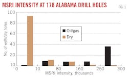
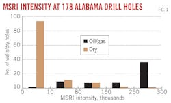
Over a 30-year period, 178 Alabama cuttings were MSRI measured, 116 from dry holes and 62 from wells. All MS measurements were made at the GSAL storage in Tuscaloosa and from Midroc Operating Co. exploration.
Table 1 and Fig. 1 show numbers of wells and dry holes for intensity ranges of MSRI. Alabama cuttings are from Escambia, Monroe, Clarke, Conecuh, and Covington counties. Field wells for MSRI >250K are shown in Table 2.
MSRI data indicate that Alabama operators should measure MS on location for all exploratory drill holes through the Selma chalk. A dry hole is highly probably when MSRI measurements through the Selma chalk are at background (Table 3). If the MSRI is greater than 10K, drilling should continue.
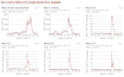
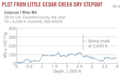
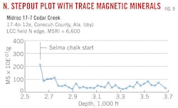
Well plots for MSRI > 160K, where wells in Little Cedar Creek field produce from the Lower Smackover formation at >11,500 ft, are shown in Figs. 2-7. The Fig. 8 dry hole, about 6 miles south of the field, has no Selma chalk magnetic mineral increase. The Fig. 9 dry hole, one-half mile north of the field, has perhaps a trace of magnetic minerals in the first 30-ft sample.
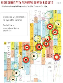
Fig. 10 shows the high sensitivity aeromagnetic survey of the Conecuh County area, Township 5 North-Range 13 East, with 12 well locations in the Little Cedar Creek field extension. The extension was leased based on airborne results prior to field drilling. Well symbols having no color are those with no available cuttings, and symbols red-circled have anomalous Selma chalk MS.
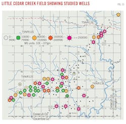
Little Cedar Creek field supplied a large number of well cuttings for the study (Figs. 2-7, 9, 10, 11, and 13).
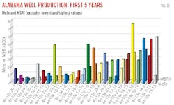
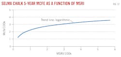
The GSAL library supplied the first 5-year oil/gas production history for 28 wells in Little Cedar Creek field. The 5-year production was compared with the MSRI. Fig. 11 shows the wells by name, with the MSRI and 5-year Mcfe. The study results show that production in Mcfe is related to increases in the MSRI (Fig. 12). The higher the MSRI, the more probable is an excellent producing well.
Only MS plots having full Selma chalk measurement are included in Figs. 11 and 12. Two outlier wells, one each having very high and very low production, were excluded.
Fig. 13 shows the MSRI intensity of wells analyzed. Some wells were measured and not colored because they had incomplete or rust-contaminated cuttings in the Selma chalk. Midroc Operating supplied the LCC cuttings as wells were being drilled.
Using large MSRI to evaluate deeper horizons
MS measurements from southwest Alabama reveal a magnetic anomaly from a single horizon, the Selma chalk, over oil fields.
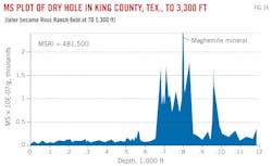
Other areas reveal magnetic alterations from shallower multiple horizons, as in the Texas example of Fig. 14.
This exploratory dry hole, drilled over the future Ross Ranch field in King County, Tex., to a depth of 3,300 ft, gives MSRI = 481.5K. Drilling several years later to 5,300 ft discovered the Ross Ranch field. Had the high MSRI been known, and the value of this information been recognized, initial drilling would have made the discovery.
Summary
Fig. 12 supports capture and MS measurement to produce the MSRI of Alabama Selma chalk cuttings during drilling.
After drilling through the Selma chalk formation and development of the MS plot, the probability of eventual success and 5-year Mcfe of the developing well can be estimated. MSRI should be monitored to assist management in drilling decisions.
Similar reasoning may apply in other regions. Fig. 14 justifies deepening a high MSRI well to a producing horizon. The technique of using MSRI to discover Ross Ranch field was not available. Cuttings MS measurement at the drillsite is very simple to accomplish at minimal expense of equipment and time and should be standard procedure in worldwide exploration.
Appendix
MSRI is calculated from the MS plot in ordinate units of 10-7/g as: (sum over MS anomaly of MS amplitude of each 30-ft-spaced sample)(number of 30-ft samples in anomaly)(30). Magnetic susceptibility is the ratio of the amount a substance may be magnetized relative to an applied field.
Acknowledgment
The author thanks M.L. Foote for proofreading and for developing the 5-year Mcfe and MSRI relationships in Figs. 11 and 12.
Reference
1. Mossbauer technique measurements, Dr. Gary Long, University of Missouri-Rolla.
Bibliography
Donovan, T.J., et al., "Aeromagnetic detection of diagenetic magnetite over oil fields," AAPG Bull., Vol. 63, 1979, pp. 245-248.
Foote, R.S., "Use of magnetic field aids oil search," OGJ, Vol. 9, No. 18, 1992, pp. 137-141.
Foote, R.S., "Relationship of near-surface magnetic anomalies to oil and gas producing areas," AAPG Memoir 66, 1994, pp. 111-126.
Liu, Q., et al., "Relationship between magnetic anomalies and hydrocarbon microseepage above the Jingbian gas field, Ordos basin, China," AAPG Bull., Vol. 88, No. 2, 2004, pp. 241-251.
Foote, R.S., Nowak, R., and Sobehrad, J., "Aeromagnetic near-surface profiling as an exploration tool," Application of Emerging Technologies, 5th in the ISEM Unconventional Methods, Southern Methodist University, 1997.
Sobehrad, J., and Foote, R.S., "Aerial magnetic reconnaissance technique finds leads in Morocco," OGJ, Oct. 25, 2004, pp. 44-48.
Foote, R.S., "Method helps find hydrocarbon areas, aids optimum seismic survey planning," OGJ, Feb. 5, 2007, pp. 35-38.
The author
Robert S. Foote is owner of Geoscience & Technology Inc. and Geoscience International Inc. He has been working with magnetic field measurement for more than 30 years and developed the use of SRM and MBS technology. He worked with Texas Instruments developing the initial digital seismic field system. He formed Geodata International Inc. and was part of the NURE program in the search for uranium. He has a BS and MS in physics from the University of Illinois.
