SOUTHEAST LOUISIANA SHALLOW GAS—1: Louisiana lagniappe: shallow gas play concept, evaluation techniques, analogs
Andy Clifford
Saratoga Resources Inc.
Houston
Elizabeth Goodman
Saratoga Resources Inc.
Covington, La.
There have been a number of successful completions of shallow Plio-Pleistocene gas in Southeast Louisiana at depths of less than 3,500 ft.
The play has been largely ignored, however, due to historical lack of gas demand, increased costs for compression and completion, poor seismic imaging, and lack of logs to evaluate. Methods used to evaluate the shallow gas play include detailed seismic processing and AVO analysis, coupled with cased-hole logging.
Part 1 of this article will describe the play concept and evaluation techniques and describe specific examples of field analogs.
Part 2 will show a specific case study from Grand Bay and Main Pass 47 fields, including reprocessing of Saratoga's proprietary 3D survey, cased-hole logging, and examples of specific prospects and well economics.
Numerous shallow gas prospects have been identified at Grand Bay with potential for up to 50 bcf of undeveloped, shallow Plio-Pleistocene gas that will be targeted through recompletions and with the drill bit in the next 2-3 years. The 50 bcf estimate does not cover all the fields in Fig. 3 or Table 1 but only Grand Bay plus Saratoga's portions of Coquille Bay and Main Pass 47.
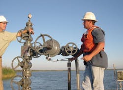
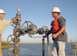
Saratoga field engineers check the QQ-15 shallow gas well in Main Pass 47 field, Plaquemines Parish, La. (Fig. 1).
Play concepts and recognition
Lagniappe is a term commonly used in the Gulf Coast region, especially in Louisiana, to describe a small gift or something given or obtained gratuitously or by way of good measure. Such is the case with the shallow gas play in many of Southeast Louisiana's fields.
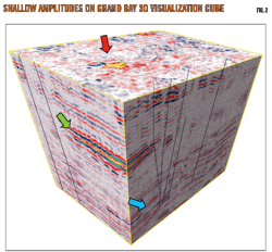
Fig. 2 is a visualization cube extracted from Saratoga's proprietary 3D seismic volume at Grand Bay field in Plaquemines Parish, La. The colored arrows point to shallow seismic amplitudes that are most likely related to shallow gas deposits. The magenta arrow relates to a prospect that lies above 1,500 ft, the green arrow to one at 1,500-3,000 ft, and the blue arrow to a prospect below 3,000 ft.
The black semivertical lines on the cube are fault traces. These faults are considered important for migration of the shallow gas from deeper-seated source beds.
Shallow gas is a relative term but is herein defined as natural gas occurring at subsurface depths of less than 4,000 ft. Shallow natural gas can be generally classified as either thermogenic gas, generated at depth within the basin and migrated up faults as free gas or as gas associated with oil, or biogenic gas. The latter can be further subdivided as either early generation or late generation biogenic gas.
Hydrocarbons found in the Plio-Pleistocene section above 4,000 ft are generally thought to be dry gases and of biogenic origin. In general, we regard the section down to a depth of 2,000 ft as being Pleistocene and the section between 2,000 and 4,000 ft as being Pliocene in age. As far as this study is concerned we will simply group all existing and potential shallow gas sands above 4,000 ft as Plio-Pleistocene.
Since there are little or no associated liquids and the fact that gas reserves at shallow depths are often perceived to be small, there has been little development of these reserves in Southeast Louisiana. Some of the reasons for their lack of development are:
• Modest pool sizes, generally less than 1 bcf.
• The extra expense required for compression due to low reservoir pressure.
• The need for gravel pack completions due to loose, unconsolidated sands.
• Historically low natural gas pricing. Until relatively recently, natural gas was an unwanted by-product because gas prices were low compared with crude oil.
Oil companies often didn't even log the shallow section of hole, corresponding to the surface casing. Many wells in Southeast Louisiana do not have logs covering the shallowest 2,000 to 3,000 ft of hole. Therefore, most accumulations are still intact and represent virgin reserves.
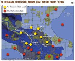
Shallow gas has been successfully developed in a number of Southeast Louisiana fields, some of which are shown on Fig. 3 with completions listed on Table 1.
Oil and gas in the Southeast Louisiana fields are suspected to have migrated up the large listric faults that plumb the deeper source beds in the Cretaceous and Jurassic. The absence of liquid hydrocarbons in shallow gas accumulations to date leads the authors to suspect that the gas is biogenic and locally sourced.
A counter argument to this statement is that the majority of seismic amplitudes associated with shallow gas occurrences line up along the shallow expression of deeper listric faults so at least some of the gas likely migrated up the faults from deeper zones.
Seismic data reveal that many of the seismic amplitudes line up along faults as can be clearly seen in Fig. 4, a 3D seismic arbitrary line across Romere Pass field. The red arrow points to a known gas occurrence, the 2,100-ft sand, which was produced by the U-113 well (see Table 1).
Other amplitudes might look promising but are either not logged or need further detailed seismic analysis. Note that the shallow section in wells U-65, U-83, and U-96 is not logged. A typical gas signature is a trough (yellow) over peak (blue) or a peak-trough-peak. Therefore, with respect to Fig. 4, note the 2,100-ft gas sand at 0.750 sec two-way travel time (TWTT) with the strong peak-trough-peak signature and compare with the other anomalies at 1.16 sec (likely not gas-bearing) and 0.480 sec (possibly gas-bearing).
Pool sizes in the Plio-Pleistocene in Southeast Louisiana can be as large as 3 bcf and average 530 MMcf (see Table 1) in recoverable reserves. Net pays range from 2 to 20 ft with an average of 8.77 ft (Fig. 5).
Such reserves are modest compared to deeper Miocene reservoirs, but the shallow depths of these pools require lower capital costs for exploration drilling and development, notwithstanding the earlier comments concerning compression and gravel pack completions. One of the most significant costs in shallow gas development is the need for gravel pack completions to prevent the production of loose, unconsolidated sand that, if unprotected, will cause premature cessation of production.
The authors will show economics of a typical shallow gas prospect in Grand Bay field in Part 2 of this article.
Evaluation techniques
Shallow gas accumulations are ideally suited for detection by the use of 3D seismic data.
The acoustical contrasts of gas vs. water often provide ""bright spots" or "direct hydrocarbon indicators" on seismic panels, but the seismic is generally ambiguous as to the thickness of the pay zone.
A common problem is the absence of good quality seismic data corresponding to the shallow section above 3,000 ft. There are three primary reasons for this:
1. The first second of recorded seismic data historically has lower CDP fold and hence has less usable signal;
2. Any usable signal existing in the data is often muted out during seismic processing;
3. There was little incentive in oil companies to spend too much money on processing efforts in order to improve the signal-to-noise ratio or enhance the imaging of shallow seismic events when the most likely product was natural gas.
Seismic data conditioning
Saratoga spent a lot of time and effort reprocessing its 90 sq mile proprietary 3D seismic survey at Grand Bay in order to better image shallow seismic events above 1 sec TWTT in order to tie seismic amplitudes to known shallow gas pay.
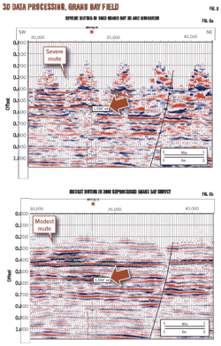
The shallow section had a fairly severe mute on it, making it impossible to follow the extent of potential shallow gas reservoirs. Figs. 6a and 6b show a comparison of the mute applied to the original processing and Saratoga's reprocessing of the same data.
The muting of the shallow data shown in Fig. 6a affects the shallowest 400 to 600 ms of data (approximately down to 1,500 ft. Logs are displayed in magenta lines; note how the top of logging starts at 850 ms in the QQ-15 well. Fig. 6b clearly shows better continuity of the seismic reflectors as well as better fault definition.
There is a risk associated with reducing the mute since it is possible to create and at the same time degrade amplitudes that could make the shallow seismic data even more confusing and unreliable. In the quest to bring out the shallow section, an interpreter must be very cautious about using the shallow seismic section above 700 ms TWTT for mapping structure rather than for amplitude analysis.
Shallow gas anomalies often have an amplitude variation with offset (AVO) response and attenuation, which is a gradual loss in intensity of seismic energy. AVO analysis consists of an examination of seismic reflections at varying source-receiver offsets. The analysis constitutes a search for anomalous seismic response with offset and generally works well in evaluating these shallow gas reservoirs.
Shallow gas pay typically shows up as a Class 3 AVO anomaly in which the acoustic impedance of the gas sand drops with respect to the encasing shales. The main risk with AVO analysis is whether any seismic amplitude anomalies are low-saturation, noncommercial ("fizz") gas or a gas accumulation of commercial quantity.
Validation of shallow seismic amplitudes can also be enhanced by finding potential seismic gas chimneys that stop at the anomaly rather than breaking through that anomaly. Vertical hydrocarbon migration pathways can often be observed in 3D data as broad diffuse zones of chaotic, often low-amplitude data called gas chimneys or gas clouds.
These gas chimneys can be analyzed to show where they originate, giving clues to whether they contain oil or gas, to show where the chimneys terminate, giving a clue to the timing of migration, and studied in three dimensions to see how they are related to possible reservoirs. The process for delineating these hydrocarbon migration pathways is called "gas chimney processing."
Vertical discontinuities in seismic data can result from a number of causes other than gas migration. True hydrocarbon migration pathways can be substantiated in a number of ways especially if they are associated with direct hydrocarbon indicators or if the chimneys link to shallow sea-bottom indicators of hydrocarbons.
Fig. 7 shows a gas chimney processing display from Grand Bay field. The yellow and green overprint shows interpreted gas chimneys. Note the chimneys in the top right part of the figure relating to potential migration up the large listric fault as well as possible biogenic gas apparently unrelated to fault migration.
The red arrow in Fig. 7 points to potential migration pathways for shallow biogenic gas from relatively shallow beds, unassociated with faulting, the blue arrow to potential migration from a deep, thermogenic source, and the green arrow to the top of geopressure.
Saratoga reprocessed the Grand Bay 3D data in 2008 in order to better image the shallow section above 700 ms TWTT. This was done by applying a less severe mute to the seismic gathers.
Once the reprocessing was completed, it was possible to suddenly see the seismic amplitude response associated with some of the gas discoveries north of the field. In fact, a large number of seismic amplitude anomalies became evident, and many of these coincided with locations where wells had been drilled for deeper objectives.
Unfortunately, the shallow section had not been logged, and there are only a handful of the 400-plus wells in Grand Bay and Main Pass 47 fields with shallow logs. Fig. 8 is a seismic display through some seismic anomalies associated with the QQ-15 well showing the top of logs for three wells at approximately 850 ms TWTT.
A technique that can be deployed in wells that were not previously logged in the shallow section is to run a cased-hole reservoir saturation tool (RST) or pulsed neutron (PNL) logs. Saratoga has successfully used this technology in wells that were not previously logged in order to detect shallow gas.
Cased-hole logging
Cased-hole logs, particularly the RST log, has had wide application throughout the world for many years. Its measurement of the time rate of decay of thermal neutrons is affected primarily by chlorine in the high-salinity formation waters found in many parts of the world.
Combining this effect with its ability to be run through casing has led to its use in determining water saturation and porosity in cased holes. The RST log's ability to detect hydrocarbons, to monitor changes in hydrocarbon saturation, and to identify hydrocarbon types in high-salinity water formations is well documented.
Fig. 9 shows an example of an interpreted RST log from the QQ-3 well in Main Pass 47 field. This well was originally logged to a depth of 4,000 ft, so there was no way to evaluate shallow gas potential above that depth until the RST log was run.
Fig. 9 shows interpreted bypassed gas sand with approximately 50 net ft of gas pay (NFG) at a depth of 1,022 ft. Porosity cutoff for this analysis was 5%, shale cutoff was 50%. Another example that was successfully used by Saratoga at the QQ-15 well will be described in Part 2 of this article. A typical cased-hole logging run will cost around $35,000.
Productive analogs
There have been a large number of successful shallow gas completions in the fields surrounding Grand Bay (Table 1). Initial production rates for these wells generally average 500 Mcfd.
North of Grand Bay, two small operators successfully developed shallow gas. Commerce Energy had a number of successful wells 8 miles northeast of Grand Bay, just outside Saratoga's 3D survey. The 800-ft sand had cumulative production of 340 MMcf from 4 wells, the 900-ft sand produced 3,197 MMcf from 7 wells, the 1,200-ft sand produced 262 MMcf from 1 well, and the 1,500-ft sand produced 3,626 MMcf from 4 wells.
These sands are shown in the type log from the Commerce I.R. Price-4 well (Fig. 10).
Another successful developer of shallow gas in Southeast Louisiana was Badger Oil in Main Pass 47. The SL 14646-2 (Badger-2) well was drilled by Badger in 2001. The well was recompleted as a gas well in the 1,550-ft sand with 10 NFG and perforations 1,547-53 ft. The well had an IP rate of 1,000 Mcfd with 550 psi flowing tubing pressure and 640 psi shut-in tubing pressure through an 18⁄64-in. choke. Cumulative production for this reservoir was 74,457 Mcf.
Based on average pay thickness of 5 ft and a recovery factor of 388 Mcf/acre-ft, the areal extent of the seismic amplitude was calculated to be 40 acres. Gas was also produced from the 1,850-ft and 1,950-ft sands with almost 1,000 MMcf produced in total between the three sands.
Fig. 11 shows the amplitude response to the 1,550-ft, 1,850-ft, and 1,950-ft gas sands in the Badger-2 well.
While the 1,850-ft sand (blue arrow) shows the typical trough over peak on this PSTM Far Offsets display, any amplitude associated with the deeper 1,950-ft sand (red arrow) must be masked by the overlying 1,850-ft sand. The 1,550-ft sand (green arrow) shows more of a peak over trough. Not surprisingly, the 1,550-ft sand was wet in the nearby SL 14646-1 (Badger-1) well.
The Badger-1 well had a gas show in the 1,950-ft sand and pay in the 1,850-ft sand. The latter had an IP rate of 1,675 Mcfd with 725 psi FTP, 760 psi SITP through an 18⁄64-in. choke with perforations 1,847-67 ft. The shallowest amplitude (yellow arrow) appears to be either wet or to have low saturation gas.
There has also been successful development of shallow gas at Romere Pass field, immediately southeast of Grand Bay.
The RPU-79 (U-79) well was drilled by Jetta to a total depth of 2,220 ft, specifically targeting shallow gas. The well produced over 3,000 MMcf from the 2,100-ft sand. The well was completed as a gas well with perforations at 2,139-51 ft and had an IP of 2,531 Mcfd with 730 psi FTP through a 23⁄64-in. choke.
The RPU-113 (U-113) well, drilled by Texas Petroleum Investment Co., was completed as a gas well in 2003 in the same 2,100-ft sand with perforations at 2,150-66 ft. The well had an IP of 6,718 Mcfd with 800 psi FTP and 551 psi SITP through a 46⁄64-in. choke and had cumulative production of 1,500 MMcf.
Fig. 12 is a display of AVO analysis of the Romere Pass wells. Far offsets are often compared to mid offsets and near offsets in order to look for possible gas effects. There is a strong trough over peak in each of the three panels (red arrows), but the leading peak brightens significantly in the mid and far offsets for the productive 2,100-ft sand event. The blue and green arrows point to other potential gas sands that are apparently untested.
The seismic amplitude associated with the 2,100-ft sand drained by the U-79 and U-113 wells covers an area of 856 acres (Fig. 12). The line of section in Fig. 12 is shown by the purple arrows in Fig. 13.
The same 2,100-ft sand was unsuccessfully tested in the GPLD A-35 well at Grand Bay through perforations at 2,105-25 ft. However, 3D PSTM seismic data show no amplitude, and the sidewall core report for that well suggests the 2,100-ft sand is calcareous in this vicinity.
There was resistivity associated with the 2,100-ft sand in a number of other Grand Bay wells, many of which were plugged and abandoned without testing, due to a lack of analogs at the time they were drilled. This shows that careful detailed seismic and log analysis is necessary for success in the shallow gas play.
However, there have also been some examples of shallow gas success at Grand Bay. The GPLD-1 well was successfully completed in the 3,000-ft sand with perforations at 3,049-58 ft with IP rate of 438 Mcfd with 1,150 psi FTP. This is amplitude associated pay with estimated recoverable reserves of 300 MMcf, assuming areal extent of 107 acres, 8 NFG, and a recovery factor of 350 Mcf/acre-ft.
The SL 195 QQ-203 (QQ-203) well perforated the 3,400-ft sand at 3,334-40 ft and had cumulative production of 963 MMcf plus 35 bbl of oil. The seismic amplitude covers an areal extent of 151 acres, giving a recovery factor of 1,000 Mcf/acre-ft.
The PPG-1 well was originally completed in 1995 as a gas well in the deeper 5,150-ft sand but was recompleted in 1998 in the 3,730-ft sand with perforations at 4,060-70 ft. The IP rate was 1,411 Mcfd with 1,320 psi FTP through a 14⁄64-in. choke.
Part 2 will show a specific case study from Grand Bay and Main Pass 47 fields, including reprocessing of Saratoga's proprietary 3D survey, cased-hole logging results, and examples of specific prospects and well economics. Numerous shallow gas prospects have been identified at Grand Bay with potential for up to 50 bcf of undeveloped, shallow Plio-Pleistocene gas that will be targeted through recompletions and with the drillbit in the next 2-3 years.
Next: Case study from Grand Bay and Main Pass 47 fields.
The authors
More Oil & Gas Journal Current Issue Articles
More Oil & Gas Journal Archives Issue Articles
View Oil and Gas Articles on PennEnergy.com
