Unlocking Grand Bay's deep treasures: gulf shelf potential at 17,000-28,000 ft
Grand Bay field in the Mississippi Delta is the "Grande Dame" of southern Louisiana. The field has continued to produce vast quantities of oil and gas for over 70 years and promises to do so for another 40-50 years from already discovered normally pressured reservoirs.
Recent interpretation of reprocessed proprietary 3D seismic data has revealed several large deep shelf prospects that have combined potential for over 1.6 billion bbl of oil equivalent. Even if some of these deep prospects prove successful, the recoverable reserves will far exceed the 250 million bbl of oil equivalent produced to date.
Deep shelf plays are those lying at depths of 15,000-20,000 ft in less than 600 ft of water. These plays typically overlie a salt weld, formed by salt evacuation, and offer targets of 100 bcf to 1 tcf of gas equivalent per prospect.
Ultradeep shelf plays target reservoirs below the salt weld with individual prospect sizes of 500 bcfe-1 tcfe at depths in excess of 20,000 ft. Interest in deep shelf and ultradeep plays in the Gulf of Mexico has been spurred by recent successes such as McMoRan's Davy Jones. Such deep prospects are similar to those found in deep water but have shorter lead times to first production and lower development costs.
Saratoga has identified a suite of similar deep Miocene and Lower Tertiary prospects in less than 10 ft of water under existing held-by-production leases and adjacent to existing infrastructure such that first production can be achieved quickly and at low cost.
Grand Bay field
Grand Bay field is in Plaquemines Parish, La., 60 miles southeast of New Orleans, east of the Mississippi River in the Mississippi Delta in water as deep as 12 ft. The field was discovered by Gulf Oil in 1938, and production to date has been from 64 productive horizons ranging in depth from 1,600 ft to 13,000 ft. The field has produced 213 million bbl of oil and condensate and 262 bcf of gas to date.
Saratoga reprocessed the Grand Bay 3D survey in 2008, and the effort has resulted in an exceptional improvement in data quality, especially relating to definition of shallow Pliocene gas objectives, fault delineation, and mapping of deep oil and gas potential in the geopressured section below the drilled depth of most of the field's wellbores.
As can be seen on Fig. 1, the section beneath 3 sec two-way travel time (approximately 12,000 ft) has had few penetrations and is virtually unexplored, even though this section is productive in the Breton Sound and Main Pass areas to the immediate north, as will be explained later. Only three wells at Grand Bay field have been drilled below 15,000 ft.
Regional geology
Grand Bay is a faulted anticline structure, the anticline being one of a series located along a salt ridge that extends from Delta Duck Club to the southeast and trends northwest through Romere Pass, Grand Bay, and Coquille Bay fields.
Grand Bay field is situated on the eastern flank of a Miocene depocenter known as the Terrebonne trough.1 Salt is encountered at Delta Duck Club, 10 miles to the southeast, and in a deep wildcat north of Coquille Bay, 5 miles to the north-northwest, but no salt has yet been seen at Grand Bay with drilling to 17,000 ft.
Seismic interpretation of Saratoga's reprocessed 3D survey shows Grand Bay to be a turtle structure formed by the withdrawal of allochthonous Louann salt, leaving a distinctive salt weld throughout the area. Turtle structures are extremely prospective for hydrocarbons because they are caused by salt withdrawal which allows for increased accumulation of reservoir sands in the vacated space.
Grand Bay field is productive from deltaic sands ranging in age from the Middle Miocene Cibicides carstensi (Cib Carst) to Upper Miocene Textularia "X" (Tex X) biozones. Structurally, the field is broken into three main fault blocks with most of the reserves to date having been trapped in a northwest-southeast trending anticline formed by rollover into the Upper Miocene down-to-the-basin fault system. The reservoirs are generally normally pressured to 11,500 ft and geopressured below this depth.
While the normally pressured reservoirs typically show a strong water drive, deeper sands in the geopressured section are depletion drive. Below the main field pays, the deeper geopressured Cib Carst 25 and 30 sands were deposited in a deepwater environment. While stratigraphically complex, these sparsely tested sands offer significant opportunities for exploitation.
Equivalent deep sands provide the dominant reservoirs at Bastian Bay field 12 miles to the west. This 2.3 tcfe field is located on the northern flank of the Terrebonne trough in a similar structural setting to Grand Bay. The equivalent 25 sands have produced 704 bcfe, and the equivalent 30 sands have produced 484 bcfe.
Additional potential exists in deeper Textularia "W" (Tex W), Bigenerina humblei (Big Hum), and Cristellaria "I" (Cris I) sands, which are all productive just a short distance to the north in the Breton Sound and Main Pass areas. In the latter area, the majority of the production is from traps with north-dipping upthrown fault closures, similar in style to the deep prospects mapped by Saratoga at Grand Bay. Big Hum and Cris I sands are productive to the north of Grand Bay with excellent reservoir characteristics.
Log and core analysis of Big Hum sands in the Main Pass area shows excellent reservoir quality with porosities of over 20% and permeabilities in excess of 100 md (Fig. 2). Several wells in the Breton Sound and Main Pass areas also encountered pre-Cris I (Cib Op, Vicksburg, Jackson) reservoirs.
Log analysis shows that good quality reservoirs can be expected at depths of over 15,000 ft. The Cris I "Hollywood" sand produced from a number of wells, including the Conoco State Lease 14964-1 and Chevron S.L. 5905-1 wells. The productive sand from the latter well has 85 ft of net pay with 11% clay, 17% average porosity, 21% average permeability, and 44% average water saturation (Fig. 3).
Deep shelf potential
Interest in deep shelf and ultradeep plays in the Gulf of Mexico has increased greatly of late due to recent successes at McMoRan's Davy Jones in the Lower Tertiary Wilcox and Century's Breton Sound 53 successes in the Middle Miocene Cris I "Hollywood" sand.
Other notable successes are Blackbeard West and Cote de Mer. Such deep prospects are similar to those found in deep water but have shorter lead times to first production and lower development costs.
One of the primary risks with deep shelf plays is the presence of reservoir quality sands. With regard to deep shelf plays, as with deepwater exploration in its early days, there is little well control to define play fairways with only 6% of all wells on the Gulf of Mexico shelf having penetrated below 15,000 ft.2
Furthermore, the 3D seismic data that currently exist rarely image deep enough to interpret and map structures below 20,000 ft. Seismic amplitudes are generally absent at such depths, so whether or not they are indicative of porosity or hydrocarbons, the geoscientist has little to go on with regards to reservoir prediction.
The possible presence of "regression pressured shales" beneath geopressured reservoir sands could lead to lower temperatures and pressures in the subweld sequence.2 Studies have shown that major growth faults, such as those at Grand Bay, provide conduits for emplacement of hot, acidic waters from deeply-buried Mesozoic strata into Miocene sands, leading to reservoir enhancement by calcite dissolution.3
Reservoir quality can be unexpectedly good for such depths of 17,000 ft to 28,000 ft due to better quality sands due to facies as well as secondary enhancement and geopressures. A number of large fields in southern Louisiana in geopressured settings have gas recoveries of 2,400 Mcf/acre-ft and condensate recoveries of 30 bbl/MMcf.
To be commercially successful, deep shelf prospects have to be larger than their shallower counterparts and there must be the potential for higher flow rates to compensate for higher drilling costs. Availability of existing infrastructure will also enhance the economics of developing such deep resources.
Most of the oil and gas discovered to date in the Gulf of Mexico were sourced from deeply buried Cretaceous and Upper Jurassic sediments. As the ancestral Mississippi Delta grew, the early Miocene sediments caused the mobile Louann salt layer to deform by differential loading with growth faulting associated with inflation and deflation of first generation allochthonous salt.4
The Terrebonne trough salt-withdrawal basin subsided into an allochthonous salt canopy of Paleogene age with the allochthonous salt having been almost totally evacuated, leaving an extensive salt weld,1 5 clearly seen on seismic data (Fig. 4).
This cross section across Grand Bay field shows a distinctive salt weld separating the overlying Middle Miocene sequence (orange) from the underlying Lower Tertiary (Vicksburg/ Jackson) and Cretaceous sequence with a large hiatus between the subweld and postweld sediments. Green arrows show the postulated migration of hydrocarbons from deeply buried source beds up the listric faults into shallower Middle to Upper Miocene reservoirs. Migration into the deeper prospects is relatively straightforward.
Previous deep exploration
Gulf Oil recognized the deep potential at Grand Bay as early as 1940 when it drilled the GPLD A-7 well and encountered a thick and well-developed sand section that flowed oil.
The company made subsequent attempts to develop this deeper section in the 1950s through the 1970s. Gulf Oil's GPLD A-60 well in 1961 tested 300 b/d of oil and 700 Mcfd on drillstem test from the Tex W 43 sand before encountering mechanical problems and completing the shallower Cib Carst 30 sand.
Following 3D seismic acquisition, Greenhill drilled the GPLD A-184 well and successfully established commercial production in the 30 sand. There has been no activity with respect to the deep, geopressured section at Grand Bay since that time. In fact, out of the more than 440 wells drilled to date at Grand Bay, less than 10% are geopressured tests.
Significant Tex W through Cris I exploration potential exists on Saratoga's acreage. Wells in the Breton Sound and Main Pass areas penetrating this section have encountered well-developed sands, and several wells (Kerr McGee S.L. 1272-11 and Magnolia S.L. 2726 A-1) have produced commercial quantities of hydrocarbons. The Exxon S.L. 14217-1 well in Breton Sound Block 34 tested 10.6 MMcfd and 775 b/d of condensate from perforations at 16,422-794 ft. Most recently, Century has had considerable success with Cris I completions achieving flow rates of up to 1,300 boe/d.
The deep shelf and ultradeep plays are known to extend beneath Grand Bay,2 6 and Saratoga has identified a suite of deep Miocene and Lower Tertiary prospects in less than 10 ft of water under existing held-by-production (HBP) leases adjacent to existing infrastructure such that first production can be achieved quickly and at low cost.
Saratoga deep shelf prospects
Saratoga has used its proprietary 3D seismic data to map several large and exciting prospects beneath the heart of Grand Bay field.
This survey covers 91 sq miles, and the data quality is excellent with penetration to over 30,000 ft. Most of the normally pressured reservoirs and some of the deeper geopressured sands exhibit either seismic amplitudes (bright spots) or have a distinct signature when hydrocarbons are present.
The Merganser prospect is located updip from the previously-mentioned A60 well and has an AVO anomaly in the Tex W sequence with estimated potential of 18 million boe recoverable.
Deeper Middle Miocene prospects on Saratoga's acreage are generally north-dipping, upthrown fault closures, analogous to productive examples farther north in Breton Sound with target depths of 13,000-21,000 ft. Several Big Hum and Cris I prospects have been mapped at Grand Bay.
These prospects are simple, faulted anticlines, characterized by isopach thicks that are believed to be turtle structures that hosted thicker sand piles, deposited from the north (Fig. 5). These prospects have over 1 billion bbl of potential, and all of them are located under Saratoga's existing 100% owned HBP leases.
The presence of 42° gravity oil in the 30 sand reservoir at 13,000 ft tends to support a bottomhole temperature interpretation, assuming an approximate temperature gradient from well data of 1.6° F./100 ft, that liquid hydrocarbons (with increasing gas-oil ratio) are thermally stable to depths of well below 20,000 ft with an interpreted oil window at approximately 22,000 ft. Therefore, although gas and condensate are the most likely hydrocarbons to be discovered in the deep, geopressured Big Hum and Cris I sands, oil cannot be precluded.
Zeus prospect targets multiple geopressured Big Hum/Cris I sands in a well defined turtle structure. These sands are well defined and productive to the immediate north in the Main Pass area. Regional geological analysis by Saratoga's geotechnical team shows over 3,000 ft of prospective section (Fig. 6).
Amplitude analysis of the Big Hum prospects like Zeus also supports the presence of porous sandstones. Zeus shows remarkable similarity to Shell's Picaroon field in offshore Texas3 with Middle Miocene Big Hum reservoirs at depths of 17,000 ft trapped in a rollover anticline in the hanging wall of a major listric fault.
Rex prospect covers over 900 acres updip from the Kerr McGee S.L. 1272-12 well that is a key control well for the Big Hum in the 3D survey. This well encountered three Big Hum sands, but regional analysis of other wells has identified over 20 stacked sands within the Big Hum and Cris I sequence (Fig. 6).
Invictus prospect lies beneath the salt weld and is prospective for Lower Tertiary and Cretaceous objectives (Fig. 7). Isochron and isopach mapping shows a paleostructure with early growth. Invictus lies at the same depth as Davy Jones and looks remarkably similar in cross-sectional view.
Regional mapping suggests that Lower Tertiary reservoirs should be present beneath the salt weld above secondary Cretaceous (Tuscaloosa) objectives. Because the Louann salt was less deformed by later build-out and loading from the Mississippi Delta in Middle Miocene times, it is more likely that the Lower Tertiary reservoirs are more sheet-like in distribution than the later Miocene sands, whose deposition was more affected by salt tectonics.
Deep well design
Saratoga contracted with Crescent Engineering of Kenner, La., to design a straight hole to test the Big Hum and Cris I section in the Zeus prospect.
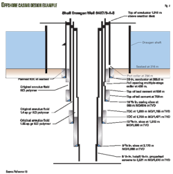
Crescent took into account a detailed study of subsurface pressures from nearby well control. Maximum expected mud weight is 18-18.5 ppg, and the well would incorporate state-of-the-art well design features, including an expandable liner for the midsection of the hole where pressures are transitional between the normally pressured 21 sand and the deeper, geopressured 25 sands and below (Fig. 8). The Zeus well is estimated to take 95 days to drill to a proposed total depth of 20,000 ft with an estimated dry hole cost of under $20 million.
Summary
Grand Bay field has yielded in excess of 250 million boe since 1938 and is still going strong.
Recent reprocessing of Saratoga's proprietary 3D seismic data has allowed mapping of deep potential similar to other deep shelf and ultradeep plays farther west such as Davy Jones with over 1 billion boe of potential.
Reservoir presence is the most significant predrill risk, but reservoir quality is expected to be good due to secondary enhancement and geopressures. Drilling cost estimates suggest that these treasures can be commercially attractive and brought to production quickly due to their proximity to Saratoga's existing infrastructure.
References
1. Schuster, D.C., "Deformation of allochthonous salt and evolution of related salt-structural systems, Eastern Louisiana Gulf Coast," in Jackson, M.P.A., Roberts, D.G., and Snelson, S., eds., "Salt Tectonics: a global perspective," AAPG Memoir 65, 1995, pp. 177-198.
2. Moffett, J.R., "Going Deep," SIPES Luncheon, Houston, Feb. 18, 2010.
3. Taylor, T.R., and Land, L.S., "Association of allochthonous waters and reservoir enhancement in deeply buried Miocene sandstones: Picaroon Field, Corsair Trend, offshore Texas," in "Siliciclastic Diagenesis and Fluid Flow: Concepts and Applications," SEPM Special Publication No. 55, 1996, pp. 36-48.
4. Risch, D.L., "Sedimentation and Salt Tectonics on the Louisiana Slope," GCSSEPM Foundation 16th Annual Research Conference—Salt, Sediment and Hydrocarbons, Dec. 3-6, 1995, pp. 209-221.
5. Peel, F.J., Travis, C.J., and Hossack, J.R., "Genetic structural provinces and salt tectonics of the Cenozoic offshore U.S. Gulf of Mexico: a preliminary analysis," in Jackson, M.P.A., Roberts, D.G., and Snelson, S., eds., "Salt Tectonics: a global perspective," AAPG Memoir 65, 1995, pp. 153-175.
6. Adkerson, R.C., McMoRan Exploration Co. presentation at Merrill Lynch 2007 Global Energy Conference, New York City, Nov. 8, 2007.
The author
Andy Clifford ([email protected]) is president and director of Saratoga Resources Inc., Houston, a small, publicly traded independent oil and gas producer with operations focused in the inshore transition zone of Louisiana state waters. With offices in Houston and Covington, La., the company operates 14 fields including Grand Bay. Clifford has more than 30 years of experience in domestic and international exploration, development, and production and a proved track record of exploration and acquisition success in practically every important basin in the world. He is credited with the discovery of over 1 billion boe of reserves in Africa, Alaska, Asia, Gulf of Mexico, Latin America, and the UK North Sea. He has a BS in geology from London University and is a frequent speaker and published author on a variety of energy related topics.
More Oil & Gas Journal Current Issue Articles
More Oil & Gas Journal Archives Issue Articles
View Oil and Gas Articles on PennEnergy.com
