Operators chase gas in three Alabama shale formations
Two emerging gas shale plays are running up against apparently steep learning curves in the Black Warrior basin and other geologic provinces to its east.
New participants, money, and equipment are about to be introduced into at least one of the plays.
One play is for gas in Middle to Late Cambrian Conasauga, and the other is for gas in Mississippian Floyd shale and Devonian Chattanooga shale.
The Conasauga play is more advanced and has the only production, Big Canoe Creek field in St. Clair County.
The top three Conasauga players have more than 800,000 acres under lease. That includes more than 500,000 acres for the 50-50 combine of Energen Resources Corp., Birmingham, and Chesapeake Energy Corp., Oklahoma City, and 300,000 acres for HighMount Black Warrior Basin LLC, Birmingham.
HighMount, a unit of New York’s giant Loews Corp., operates Big Canoe Creek since acquiring it in mid-2007 from Dominion Black Warrior Basin Inc. (OGJ, June 11, 2007, p. 32).
HighMount is said to be planning to drill at least six new wells in the field using a rig or rigs capable of drilling to 15,000 ft. This is heavier equipment than that used by the previous operator.
Energen and Chesapeake filed permits in early January 2008 for two 12,500-ft wells in Bibb County some 95 miles southwest of Big Canoe Creek. They also permitted a 9,500-ft test in northern Greene County.
And Energen recorded a 36-month lease with Temple-Inland in northern Cherokee County, Ala., north of Weiss Lake in Broomtown Valley between Lookout Mountain and the Georgia line.
Meanwhile, rundowns posted on its website by the staff of the Alabama Oil & Gas Board in November 2007 detail efforts by several operators to drill, stimulate, and complete wells in the shale plays in the last few years.
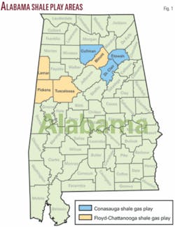
The board’s reports give details on wells in three counties in the Conasauga play and four counties in the Floyd and Chattanooga play (see map).
One board staffer said the status of the plays reminds him of the early 1980s when early coalbed methane wells were being drilled in Alabama.
Conasauga update
All of the Conasauga exploration has taken place in St. Clair County except for one well in Etowah County and one in Cullman County.
St. Clair and Etowah are northeast of Birmingham in the Valley and Ridge Province, and Cullman is north of Birmingham in the Cumberland Plateau Province.
Energen’s Bibb County locations are 1 Marchant 22-16, in 22-22n-7e, and 1 Krout 10-14, in 10-22n-9e. The Greene County location is 1 Poole 1-5, in 1-23n-3e.
Big Canoe Creek operator HighMount adopted Dominion’s Tuscaloosa staff.
As reported by the board, Dominion drilled 14 wells in the field to depths of 3,412-9,023 ft plus one well plugged at 958 ft with drilling problems before the sale to Loews/HighMount. Initial test rates reported to the board ranged from 26 Mcfd to 233 Mcfd.
Eight wells produced 6.8 MMcf of gas in August 2007. The most productive well, Burgess E28-11-58, made 2.684 MMcf of gas in August (OGJ, Sept. 24, 2007, p. 48).
Two of the most recent wells Dominion drilled are to TD 7,576 ft in 33-13s-4e and to 6,585 ft in 35-13s-4e. It cased and was attempting to complete both.
Dominion encountered lost circulation, swelling of clays, and wellbore drift at Big Canoe Creek due to the area’s unique geological conditions, the board reported.
“Rock units in this area of the state are highly folded and faulted making geologic interpretations difficult. Thrust faults, which are low angle reverse faults, are the principal faulting mechanism in the area,” the board said.
“These faults can cause an exaggerated thickness (up to several thousand feet) for the Conasauga as a result of stacking of faulted strata.”
Energen drilled two wells in St. Clair County in 2006 outside Big Canoe Creek field. The 29-12-101 Williams, in 29-14s-3e, went to TD 4,840 ft with production casing set to 3,522 ft and no test results reported. The 1 McAnulty 10-11, in 20-14s-3e, went to TD 2,365 ft and was plugged in 2007 due to drilling problems.
Energen also drilled the 1 GAA 23-12, in 23-12s-5e, Etowah County, plugged at TD 4,850 ft.
In Cullman County, Choctaw Geological Enterprises set a liner at 3,678-6,588 ft in Conasauga at the 1A Haynes Farms, in 26-9s-2w. This well site is one-half mille from a well that Shenandoah Oil Corp. and Occidental Petroleum Corp. drilled to 8,270 ft and plugged in 1972.
GeoMet Inc., Birmingham, has drilled the 06-07-04 Montgomery well in Cullman County to TD 1,998 ft and was waiting on completion rig.
Floyd-Chattanooga rundown
Exploration for Floyd-Chattanooga gas has occurred across a wider area than the Conasauga play but has resulted in little gas recovery so far.
Most of the drilling has been directed at the Floyd shale.
Lamar County
Lamar County action involved two wells by Denbury Offshore LLC, Plano, Tex., and a reentry by Samson Resources Co., Tulsa.
Denbury has produced gas intermittently since 2005 from a 2,000-ft southeasterly-trending horizontal lateral in Floyd shale at the 1 Burns 29-9, 29-17s-15w, southeastern Lamar County. It perforated the lateral at 5,350-6,820 ft measured depth at 4,856-85 ft true vertical depth. The well, acidized and hydraulically fractured in several stages, produced on 24-hr test at a rate of 80 Mcfd with 100 psi FTP on an open choke.
Denbury’s 1 Crowley 26-7, in 26-16s-14w, southeastern Lamar County, has a 2,000-ft northerly horizontal lateral in Floyd. The board issued a temporary allowable test period effective Aug. 1, 2007, after Denbury ran a frac in the lateral at 5,118-22, 5,318-22, and 5,518-22 ft.
Samson plugged the 1 Patrick 32-10, a former Lewis and Carter gas well in McGee Lake field, Lamar County, in April 2007. It perforated the Floyd at 4,538-90 ft but decided against testing.
Pickens County
Murphy Exploration & Production Co.-USA has drilled and completed three Floyd wells in Pickens County and has filed no test results with the board on any of them. The 1 Exum Trust 6-16, in 6-21s-15w, west-central Pickens County, had selective perforations in Floyd at 6,438-6,617 ft and a frac in December 2005. Earlier the company perforated a Devonian interval at 7,130-48 ft.
In southeastern Pickens, Murphy cased the 1 O’Bryant 6-15, in 6-22s-14w, to TD 7,407 ft and perforated selectively at 7,018-7,133 ft in Floyd and ran a frac. In southwestern Pickens, Murphy cased the 1 Parker 3-16, in 3-22s-16w, to TD 8,800 ft. It perforated and ran fracs in Floyd at 8,451-67 ft and Chattanooga at 8,644-57 ft.
Wagner & Brown Ltd., Midland, Tex., reentered two wells in 2006 to test Floyd. The 1 McShan-Timberlands, in 11-19s-16w, northwestern Pickens, TD 5,785 ft, was deepened to 7,000 ft from 5,785 ft and cored the Floyd at 6,322-6,500 ft. Production casing was set to TD, but a Floyd completion was not attempted.
Wagner & Brown reentered the 1 Shaw Unit 10-10, in 10-18s-15w, north-central Pickens, set production casing to 5,167 ft, perforated Floyd at 4,954-66 ft and ran a frac but filed no test results.
In northeastern Pickens, Elysium Energy LLC, Denver, drilled the 1 Gulf States 29-11, in 29-18s-13w, to TD 5,267 ft with production casing set. Elysium ran a frac on Floyd shale perforations at 5,010-13 ft, 5,064-68 ft, and 5,107-11 ft but conducted no tests.
Tuscaloosa County
Jim Walter Resources Inc., Brookwood, Ala., drilled two wells in east-central Tuscaloosa County.
It spudded the 29-16-1 JWR well, in 29-20s-7w, in December 2005, reached TD 8,529 ft in February 2006, and set production casing at 6,500 ft.
It perforated the Fort Payne chert at 5,803-32 ft and 5,852-56 ft and set a bridge plug. It then perforated Floyd at 5,621-26 ft and 5,645-50 ft, but a frac screened out.
Jim Walter perforated Chattanooga at 5,946-61 ft in September 2007, ran a frac, and set a bridge plug. It ran another frac in October 2007 over the expanded interval 5,468-5,650 ft and used gas lift to remove water.
The 28-5-2 JWR well in 28-20s-7w was cased to 6,015 ft, perforated in Fort Payne chert at 5,726-70 ft, and acidized. The board issued the permit on Oct. 5, 2007, for the drilling of a 2,100-ft horizontal well bore in Floyd that has now been drilled to TD 7,593 ft, and the well is cleaning up after frac.
Blount County
The board is holding open hole logs confidential for 6 months from the GeoMet 19-15-1 Wittmeier, in 19-12s-1e, central Blount County.
It was drilled to 1,923 ft, where production casing was set, and deepened to TD 2,060 ft. GeoMet stimulated the open hole with nitrogen and installed a pumping unit.
GeoMet drilled the 30-03-02 Wittmeier in 30-12s-1e in November 2007 to TD 2,121 ft and was preparing to set production casing. It permitted the 30-02-03 Wittmeier in Sec. 30 to 2,500 ft.
Shannon J. Flicklinger, West Salem, Ill., drilled the 1 Hudson 16-7, in 16-10s-2e, northeastern Blount County, to TD 1,516 ft in June 2007 and was waiting on orders. No casing is set.
The site is 100 ft south of a well TD’d at 8,350 ft and plugged in 1980.

