Sequence stratigraphic control on prolific HC reservoir development, Southwest Iran
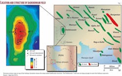
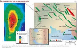
The Lowermost Cretaceous Fahliyan formation is an important carbonate reservoir in the Persian Gulf and the onshore oil fields of Southwest Iran (Fig. 1).
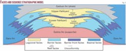
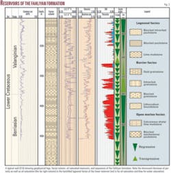
The Fahliyan formation in Darkhowain field consists of unconformity-bounded depositional sequences (Figs. 2 and 3) containing prolific hydrocarbon reservoirs of contrasting origin.
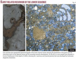
The most prolific reservoir occurs in the highstand systems tract (HST) of the lower sequence encompassing over 200 m of oil column (Fig. 3) at 4,350-4,500 m in depth. Porosity in this sequence is the result of a paleokarst event that occurred over the platform during a late Berriasian sea level lowstand and the subsequent dissolution of the originally impermeable late highstand lagoonal facies (Figs. 2 to 4).
The next significant reservoir is over 80 m thick and occurs at depths of 4,260-4,340 m. It consists of shallowing-upward cycles that are best developed within the transgressive systems tract (TST) of the upper sequence (Figs. 2 and 3).
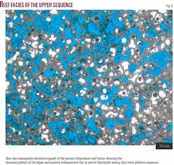
The cycles consist of a Lithocodium-dominated reef facies or a grainstone shoal facies capped by Lithocodium boundstone that developed in the high energy setting of the platform margin (Fig. 3). The porosity in the upper reservoir is mostly primary, but it was enhanced by partial dissolution during short term subaerial exposure of the platform (Fig. 5).
The Darkhowain structure is a combination trap in which the impermeable quiet water carbonates of the TST of the upper sequence have sealed the reservoirs of the Fahliyan formation, which was draped over a structure that was active during the deposition.
The widespread development of reservoirs in the platform facies and the proximity to the organic-rich, deepwater Garu formation and other important source rocks have made the Fahliyan formation one of the important exploration targets in the Persian Gulf region of Southwest Iran. The rocks with the greatest hydrocarbon reservoir potential occur within the shallow marine carbonates of the isolated platforms surrounded by the deepwater Garu intrashelf basin (Fig. 2).
The results of this study indicate that high-resolution sequence stratigraphic analysis could significantly aid exploration and enhance production, development, and secondary recovery in the Persian Gulf and other petroleum provinces.
Overview
The Lowermost Cretaceous Fahliyan formation1 is a chiefly shallow marine carbonate succession over 500 m thick that was deposited on the Persian Plate, the northeast passive margin of Gondwana. It is an important carbonate reservoir in the Persian Gulf region and the onshore areas of Southwest Iran.
In Darkhowain field, the Fahliyan formation overlies the evaporites of the Upper Jurassic Gotnia formation and underlies the Lower Cretaceous Gadvan shale with unconformable contacts (Fig. 2).
Previous stratigraphic workers1-3 considered the Fahliyan formation as a single shallow marine unit of Early Cretaceous age. Recent facies analysis and high resolution sequence stratigraphic studies, however, have revealed that the Fahliyan formation consists of two unconformity-bounded sequences of Berriasian-Valanginian age containing both shallow (restricted marine, barrier, and open marine) and deep marine (pelagic and calciturbidite) facies.4-6
The first well on the Darkhowain structure (D-1) was drilled in 1964 on a north-south trending closure near Abadan in Southwest Iran (Fig. 1). It reached the upper few meters of the Fahliyan formation with some oil shows in the Upper Cretaceous carbonates.
In 1978, a second well was drilled about 3 km north of Darkhowain No. 1 encountering two productive zones in the Fahliyan formation, but the operation was suspended due to the Iranian revolution.
The first phase of development of the field started in late 1997. The field is currently producing 55,000 b/d of oil from eight wells. The production is kept low due to limited surface facilities. Production per well from the lower reservoir is 16,000 b/d, while the maximum production from the upper reservoir is 4,000 b/d.
The second phase of development that is currently under way is expected to increase the production of Darkhowain field to 160,000 b/d. The reservoirs in Darkhowain-3 are poorly developed because it is located off the platform, where deeper-water facies were deposited and exposure to freshwater was limited.
Field structure
In a sharp contrast to the northwest-southeast trending structures of the Zagros Mountain front, Darkhowain field is a north-south trending drapeover anticline (Fig. 1) surrounded by a N-S trending, deepwater intrashelf basin.
The structure was formed during the Cretaceous prior to or during the deposition of the Fahliyan formation probably as a result of reactivation of north-south trending normal faults3 6 7 associated with the Carboniferous to Early Permian rifting of the Neotethys in Northeast Gondwana.8
The platform-to-basin facies distribution indicates that the Darkhowain structure was an isolated carbonate platform within the deepwater Garu Intrashelf basin during the entire Cretaceous.
This basin9 was the site of deposition of several thousand meters of Lower-Upper Cretaceous dark gray organic shale containing thin pelagic limestone beds and platform-derived calciturbidite layers. The Garu basinal facies changes laterally to shallow marine carbonates in the adjacent shelves and the Darkhowain isolated platform (Fig. 2).
A combination of structure and stratigraphic traps controlled the petroleum entrapment of Darkhowain field. The reservoirs in the Fahliyan formation are sealed by the transgressive quiet-water lime mudstone to packstone facies higher in the upper sequence.
Depositional setting
The Fahliyan formation mainly consists of platform carbonates composed of restricted bioclastic lime mudstone to packstone of the platform interior, Lithocodium boundstone or ooid-intraclast-bioclast grainstone of the high energy platform margin, and the bioclast packstone to lime mudstone related to the off-platform setting.
Seaward, the platform facies of the Fahliyan formation grades into the Garu formation, a dark gray organic-rich shale containing thin pelagic limestone beds and platform derived calciturbidite layers (Fig. 2). These facies reflect proximal to distal subenvironments of a carbonate shelf or an isolated carbonate platform.10 11
Together, the subsurface structure map (Fig. 1), the facies distribution, and the high resolution sequence stratigraphy show that during deposition of the Fahliyan formation, Darkhowain oil field was an isolated carbonate platform (similar to the present day Bahamas) that was surrounded by the north-south trending, deepwater Garu intrashelf basin (Figs. 1 and 2).
Sequence stratigraphic model
The sequence stratigraphic model (Fig. 2) shows facies development and lateral growth and shifting of depositional settings on the platform during Early Cretaceous sea level fluctuations.
The integration of vertical facies distribution and their paleobathymetry (using cores and well samples) and geophysical log signatures of the Fahliyan formation in the Darkhowain platform reveal the presence of two unconformity-bounded depositional sequences (third-order cycles) in the sense of Vail et al.,12 Van Wagoner et al.,13 and Sarg.14 The sequences consist of TST and HST packages composed of several short-term shallowing upward cycles (Fig. 3) and are correlated with other surface and subsurface sections in the Persian Gulf region (e.g., Lasemi et al.;4 Mohamadkhani;15 Khazaei;16 Lasemi and Nourafkan;5 and Feizi.6
The most prolific reservoir of the Fahliyan formation occurs in the HST tract of the lower sequence below the sequence boundary. A basinward progradation of the lagoonal and barrier facies during the sea-level highstand was followed by a subaerial exposure to fresh water during a late Valanginian sea level lowstand. Extensive karstification created widespread cavernous and channel porosity by diagenetic dissolution of carbonate grains and the interstitial matrix of the originally impermeable late highstand lagoonal facies (Figs. 2-4).
The most productive wells (over 16,000 b/d) are associated with this oil-saturated reservoir (over 200 m thick) at depths of 4,350-4,500 m.
In contrast to the lower sequence, the reservoir in the upper sequence is best developed within the TST (Figs. 2 and 3). The reservoir rock is a reef facies dominated by Lithocodium or ooid/bioclast or intraclast grainstone shoal facies capped by Lithocodium boundstone (Fig. 5).
Lithocodium is a calcareous alga with irregular fenestral structure (Fig. 5) that was an important reef builder during Valanginian-Aptian time.17 The upper reservoir is over 80 m thick and occurs at depths of 4,260-4,340 m.
Porosity development in the upper sequence was controlled by reef growth and the high energy setting of the shelf margin that generated primary porosity which was later enhanced by freshwater dissolution during short term sea level falls. A tight, open-marine facies capped the reservoirs forming the trap.
The highstand tract of the upper sequence is less productive or even nonproductive due to the well-cemented grainstone shoal facies and thin Lithocodium patch reefs of the lagoonal setting.
Acknowledgments
We are indebted to Jonathan Goodwin, Zakaria Lasemi, David Morse, Beverly Seyler, and Bryan Huff of the Illinois State Geological Survey, who provided helpful reviews of the original version of the manuscript. Zohreh Askari, also with the ISGS, assisted with the final drafting of the art work. The authors gratefully acknowledge the Agip/Eni Iran BV Oil Co. staff for granting us permission to use the Darkhowain data for this article. Our special thanks go to the managing director (Luigi Diamante), geosciences manager (Luca Bertoldi), Darkhowain project director (Nanzio Colabofalo), reservoir geology team leader (Lorenzo Osculati), and technical staff (Dario Sartorio, Sandro Reali, and Jalil Nasseri).
References
- James, G.A., and Wynd, J.G., “Stratigraphic nomenclature of Iranian oil consortium agreement area,” AAPG Bull., Vol. 49, 1965, pp. 2,182-2,245.
- Kheradpir, A., “Stratigraphy of the Khami Group in Southweast Iran,” NIOC Report 1235, 1975.
- Motiei, H., “Petroleum Geology of the Zagros,” Geological Survey of Iran, 1009 p., 1997, in Persian.
- Lasemi, Y., Mohammadkhani, H., Khazaei, M., and Kavoosi, M.A., “Depositional environment and sequence stratigraphy of the Fahliyan Formation in Rag-e-Sefid, Binak and Khaviz Oil Fields, south Dezful Embayment,” proceedings of the 7th Annual Meeting of the Geological Society of Iran, 2003, pp. 323-327 (in Persian with English abs.).
- Lasemi, Y., and Nourafkan, K., “Facies analysis and depositional environment of the Fahliyan Formation in the Darkhowain Oil Field, southwest Iran: Proceedings of the 9th Annual Meeting of the Geological Society of Iran, 2005, pp. 599-604 (in Persian with English abs.).
- Feizi, M., “Depositional environment and sequence stratigraphy of the Fahliyan Formation in Izeh zone and north of south Dezful Embayment, southwest Iran,” MS thesis, Dept. of Geology, Tarbiat Moallem Univ., Tehran, 2007 (in Persian with English abs.).
- Powers, R.W., Ramirez, L.F., Redmond, C.D., and Elberg, E.L., “Geology of the Arabian Peninsula, Sedimentary geology of Saudi Arabia,” USGS Prof. Paper 560-D, 1966, 147 pp.
- Lasemi, Y., “Facies Analysis, depositional environments and sequence stratigraphy of the upper Precambrian and Paleozoic rocks of Iran,” Geological Survey of Iran, 2001, 180 pp. (in Persian).
- Murris, R.J., “Middle East: Stratigraphic evolution and oil habitat,” AAPG Bull., Vol. 64, 1980, pp. 597-618.
- Wilson, J.L., “Carbonate Facies in Geological History,” Springer, Berlin, 1975, 471 pp.
- Read, J.F., “Carbonate platform facies models,” AAPG Bull., Vol. 66, 1985, pp. 860-879.
- Vail, P.R., Mitchum, R.M., Todd, R.G., Edimier, J.M., Thompson, S., Sangree, J.B., Bubb, J.N., and Hattelid, W.G., “Seismic stratigraphy and global changes of sea level,” in Payton, C.E., ed., “Seismic StratigraphyApplications to Hydrocarbon Exploration,” AAPG Memoir 26, 1977, pp. 49-212.
- Van Wagoner, J.C., Posamentier, H.W., Mitchum, R.M., Vail, P.R., Sarg, J.F., Loutit, T.S., and Hardenbol, J., “Overview of the Fundamentals of Sequence Stratigraphy and Key Definitions,” SEPM Spec. Pub. 42, 1988, pp. 39-45.
- Sarg, J.F., “Carbonate sequence stratigraphy,” in Wilgus, C.K., Hastings, B.S., Posamentier, E., Van Wagoner, J., Ross, C.A., and St. C. Kendall, C.G., eds., “Sea Level Changes: An Integrated Approach,” SEPM Spec. Pub. 42, 1988, pp. 155-181.
- Mohammadkhani, H., “Depositional environment of the Fahliyan Formation in Khaviz and Rag-e-Safid Oil Fields, south Dezful Embayment,” MS thesis, Dept. of Geology, Tarbiat Moallem Univ., Tehran, 2003 (in Persian with English abs.).
- Khazaei, M., “Depositional environment of the Fahliyan Formation in Binak and Charbisheh Oil Fields, south Dezful Embayment,” MS thesis, Dept. of Geology, Tarbiat Moallem Univ., Tehran, 2003 (in Persian with English abs.).
- Flugel, E., “Microfacies of Carbonate Rocks: Analysis, Interpretation and Application,” Springer-Verlag, Berlin, 2004, 976 pp.
The authors
Yaghoob Lasemi is a carbonate sedimentologist/reservoir geologist in the oil and gas section of the Illinois State Geological Survey. In 1981-87 he was an exploration geologist in southern Illinois. In 1987-2007 he was an assistant and associate professor of geology at Tarbiat Moallem University, Tehran. He has supervised over 80 MS and PhD theses in Tarbiat Moallem, Azad, and Isfahan Universities and has been extensively involved with teaching and research in facies analysis, depositional environments, and sequence stratigraphy. He has a BS from Tehran Teachers College (TMU), an MS in geology from Michigan State University, and a PhD in geology from the University of Illinois at Urbana-Champaign.
Khalil Nourafkan Kondroud is a PhD student in Tarbiat Moallem University. He is employed by Agip Kazakhstan North Caspian Operating Co. (Agip KCO) as a reservoir geologist. He has worked as a reservoir geologist for Agip Iran on Darkhowain oil field and South Pars gas field since 2002 as he worked on his PhD in geology. He has an MS in sedimentology from Tarbiat Moallem University and a BS in geology from Tabriz University.
