Newark basin log data indicate big gas potential in Pennsylvania, New Jersey
Exploration geologists have expressed an interest in the hydrocarbon potential of the Mesozoic basins of eastern North America in the last three decades.
The author has presented his arguments for the potential of the Newark basin of New Jersey and Pennsylvania.1-6 Until recently, his arguments have been limited by the lack of subsurface data for the basin.
In the mid-1980s, two exploratory wells were drilled in the Pennsylvania portion of the Newark Basin.
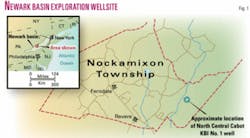
The North Central Oil Corp. Cabot KBI No. 1 is located in Nockamixon Township, Bucks County, Pa., and was plugged and abandoned on June 26, 1985, at TD 10,490 ft. The second well drilled was the North Central Joseph Parestis No. 1; it is located in New Hanover Township, Montgomery County, Pa., and was plugged and abandoned in December 1987 at TD 6,718 ft.
In addition, reflection seismic data have become commercially available, and one processed line has appeared in a number of technical publications.
Recently, well information for the Cabot KBI No. 1 well, which was previously held tight, became available from a variety of governmental sources. The author had the opportunity to analyze the available data, and has found some answers to questions regarding the potential of this basin.
The purpose of this article is to update the information on the potential of the Newark basin that the author previously discussed in other papers. An offset to the Cabot KBI No. 1 well, 40 miles north of downtown Philadelphia near the Delaware River and New Jersey, may be drilled as soon as 2007 (OGJ Online, Apr. 5, 2006).
Regional geology
The Newark basin is an exposed, elongate basin of Mesozoic age (Late Triassic to Middle Jurassic) that extends from New Jersey to Maryland (Fig. 1).

The basin is noted for its local exposures of red clastic rocks and diabase dikes. More current analysis suggests that the Newark basin is one of a series of half-graben structures that formed in North America, northwestern Africa, and western Europe in response to the breakup of the Pangaea supercontinent.
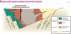
In the 1970s, a new interpretation of sedimentation in the basin suggested that lateral transitional facies from clastics along basin margins to organic shales in the basin center was a more accurate representation of basin sedimentation. Before this time, the interpretation of basin sedimentation was a simple “pancake layering” of fine-grained clastic sedimentary rocks.
The new interpretation is important because it suggests that sandstones with porosity and permeability could lie adjacent to organic shale with a relatively high total organic carbon (TOC), forming significant reservoirs. A diagram showing this new model and its facies relationships is provided (Fig. 2).
Before the 1980s drilling program, at least two seismic surveys were run in the area.
The first, called the NORPAC NB-1 line, was a publicly funded research line that has been reprocessed by a number of private companies. This line is located in eastern Bucks County, Pennsylvania, and runs essentially parallel to the Delaware River. An interpretation of this line is provided in Fig. 3.
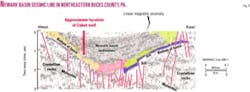
A second line was shot by Exxon and has not to the author’s knowledge been published in any technical journal. This line traverses the boundary between Montgomery and Bucks counties, Pa.
Both seismic lines show essentially the same basin makeup. Lower Paleozoic carbonates and metamorphic rocks of Paleozoic and Precambrian age distinctly define the base of the overlying half-graben. In the graben proper, clastic rocks (sandstone and conglomerates) transition into a layered, apparently denser rock in basin center (organic shale).
There is a broad and irregular transition zone between the two rock types suggesting facies transitions and, from the author’s viewpoint, trap formation. The presence of diabase is also indicated as basal sills or as dikes associated with boundary faults. Analysis done by the author as part of an unpublished senior project suggests that the metamorphic effect of these dikes is limited to within one mile of the intrusion. There is no evidence to suggest that there has been any diminishment of the reservoir or source rocks by the diabase.
Log analysis
The author provides two sections of the lithodensity log for the Cabot well.
Apparently, a complete suite of logs was run for this well, but only the sonic log and the lithodensity log are available for analysis. The author has digitized these logs to clarify the recorded parameters on an otherwise smudged final copy log.
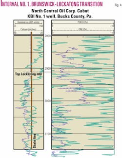
Fig. 4 shows the transition from the Brunswick to Lockatong member. The Brunswick is a reddish brown interbedded shale and siltstone that extends across the basin. The Lockatong, as mentioned above, is the traditional name given to the organic shale facies member.
The caliper log for the Lockatong suggests that there are multiple thin beds that may be separated by bed parting or fracturing. The gamma ray log suggests that these beds are interbedded siltstone and organic shale. Analysis of the neutron porosity and the density tool indicated that porosity development occurred in the organic shale member.
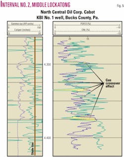
Similar developments are found in Fig. 5, which is taken from a slightly deeper interval in the Lockatong member. In addition, there appears to be registered a gas crossover effect in several intervals of organic shale/silt interfaces.
A gas crossover effect is a logging effect in which density log reads a higher porosity than the neutron log. Typically, these tools have an opposite response unless they measure a gas filled porous interval. Comparison of the caliper log and the porosity response suggests that there is a release of a signature gas along naturally occurring bed partings and fractures.
Synopsis
The results of drilling the two wells in the Newark basin of Pennsylvania provided an initial insight into subsurface conditions.
It allows a broad correlation of seismic data with subsurface conditions. It also exposed the fact that the subsurface characteristics of this basin are more complex than the “cookie cutter” geology that has been imposed upon it since the mid-1800s.
Reservoir analysis suggests that there is a thick, organically rich, siltstone-shale-mudstone complex in basin center that is apparently equal to other great fractured shale reservoirs.
With a thickness ranging from 2,500 ft to over 4,000 ft, the Lockatong member could host many significant local reservoirs that could produce economic amounts of relatively dry natural gas. In addition, there is a possibility that sandstones with porosity might lie in proximity to the organic shale, and could, under the proper conditions, be significantly large natural gas reservoirs.
Finally, the author believes his original model for the basin is still viable. If this is the case, then fluvial sand buildups in proximity to the organic shale could be present and could form significant sand reservoirs.
There is too little subsurface information available to the geological community to allow a more precise discussion of reservoir development or location at this time. What can be stated is that there is a good possibility that a significant reservoir in an economically attractive location may be present.
The author will conclude with the comments of two geologists who do not wish to be identified. One geologist said, “This reservoir looks better than the Barnett, even at this early stage of development.” The other said, “Given the limitations of the dataset and the variables of basin configuration, what we may be looking at is one of the last significant, completely undeveloped reservoirs left in the world.”
The lacustrine reservoirs of the Newark basin hold great potential and should encourage further testing by drilling.
References
- Pyron, A.J., “The Mesozoic Basins of Eastern North America: Potential Reservoir or Explorationists Folly?,” Eastern Section, AAPG, September, 1991.
- Pyron, A.J., “Use of Space Based Detectors as a Strategic Tool to Evaluate the Hydrocarbon Potential of the United States,” National Aeronautics & Space Administration Visiting Investigator Program, John C. Stennis Space Center, Mississippi, Report VIP-004-93, 1993.
- Pyron, A.J., “The Mesozoic Basins of Eastern North America: Reservoirs in Waiting or Explorationist’s Folly?,” Northeast Geology and Environmental Science, Vol. 19, No. 3, 1997, pp. 143-154.
- “The Mesozoic Basins of Eastern North America: Reservoirs in Waiting or Explorationist’s Folly?,” Pittsburgh Association of Petroleum Geologists, April, 1997.
- Pyron, A.J., “Mesozoic basins of eastern North America: Exploration target whose time has come,” OGJ, Vol. 96, No. 29, 1998, pp. 94-98.
- Pyron, A.J., “The Mesozoic Basins of Eastern North America: Exploration Target Whose Time has Come,” AAPG Eastern Section meeting, Columbus, Ohio, Oct. 7-10, 1998.
Bibliography
Bentman, Hilary, “Specter of gas drilling has some uneasy in Nockamixon,” The Intelligencer, Nockamixon Township, Pa., Apr. 7, 2006.
Costain, John H., and Coruh, Cahit, “Tectonic Setting of Triassic Half Grabens in the Appalachians: Seismic Data Acquisition, Processing and Results,” in “Extensional Tectonics and Stratigraphy of the North Atlantic Margins,” Tankard, A.J., and Balkwill, H.R., eds., AAPG Memoir 46, 1989, 641 pp.
McCaslin, John C., “SE Pennsylvania hosts unusual wildcat,” OGJ, May 27, 1985, p. 185.
Olsen, P.E., “Distribution of organic matter rich lacustrine rocks in the early Mesozoic Newark Supergroup,” in Froelich, A.J., and Olsen, P.E., eds., “Proceedings of the 2nd U.S. Geological Survey Workshop on the Early Mesozoic Basins of the Eastern United States,” 1986, 147 pp.
Schlische, Roy W., “Geology of the Newark Rift Basin,” Internet presentation, 2006.
The author
Art Pyron is sole proprietor of Pyron Consulting. He has 26 years of experience in oil and gas exploration and appraisals, minerals investigations, environmental studies, and site remediation. He has an MS in geology from the University of Texas at El Paso.