APPALACHIAN NOMENCLATURE-2: Trenton-Black River suggested as common nomenclature across Appalachian basin
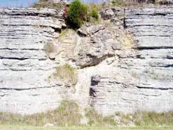
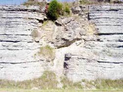
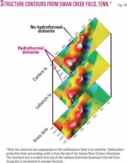
Typically small but potentially high-yield hydrothermal dolomite reservoirs in the Upper Stones River Group, such as one postulated but unconfirmed to be present in Swan Creek field, Hancock County, Tenn., commonly have structural lows over the structures because the overlying stratigraphy subsides as dolomitization continues (Figs. 9 and 10).
null
These structures, therefore, should be differentiated from synclinal trends before being prospected. Drilling structural lows is not a widespread practice, although they may be identified in seismic reflection data.
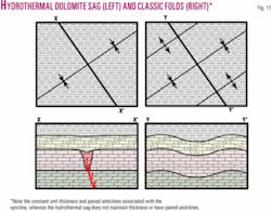
Identification of HTD structures requires the differentiation of dolomitization-related sags from synclines (Fig. 11). Dolomite sags:
- Will correspond to a thinned isopach map (for the unit that contains the dolomite), whereas folded stratigraphy does not thin or thicken near the fold hinges, especially in the synclinal hinge;
- Are characterized by localized, linear lows while synclines are typically broad and gentle linear lows;
- Will not commonly follow regional strike because they are generally controlled by basement faults and fractures; and
- Commonly do not have an anticlinal component.
MVT deposits have the highest concentration of economic minerals in the center where secondary porosity related to dolomitization and/or brecciation is cemented with gangue minerals.15 Conversely, drilling data indicate hydrocarbons typically occur on the flanks or “baked zone” halo of the MVT deposits23, 27 where the leached limestone/dolomite retains its secondary porosity (Fig. 12).
Surface analog Ordovician HTD structures in Kentucky mimic this general pattern: thin sections from within an HTD structure typically have 0-10% porosity, 5-30% porosity within 100 ft of the structure, and 0-1% regional porosity.28
This relationship has been confirmed by recent drilling in central New York, where wells in the center of an HTD structure are commonly dry and the best production is noted near the flanks of the structure.23 Horizontal drilling also enhances recovery rates because both sides of the HTD structures are tested with one hole.
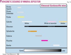
The temporal relationship between dolomitization (with or without brecciation) and mineral emplacement have been studied extensively by mining companies.15 Dolomitization commonly occurs first and is followed by precipitation of pyrite, calcite, sphalerite, galena, and fluorite, and then localization of hydrocarbons (Fig. 13).15, 28 This sequence can vary depending on the number of hydrothermal fluid pulses and the temperature and composition of the fluid.28
These relationships can be seen in thin- or polished-section to outcrop-scale exposures and have helped mining companies avoid hydrocarbons. The presence of oil is a hindrance to mining and processing and can force a company to abandon a prospect.27
Numerous test cores in Tennessee and HTD outcrops in Kentucky reveal that there commonly are not economic amounts of oil associated with these structures, making them difficult to identify or prospect in the subsurface. Most HTD outcrops in Kentucky have an areal extent of 0.1 sq mile. If they were buried to a considerable depth, they would not be positively identifiable in seismic reflection data because the associated sags and velocity contrasts would be too small.
The potential of other HTD plays is high in the Cumberland Plateau and eastern Highland Rim of southern Tennessee and northern Alabama because prospecting and drilling in that area have been very limited.
HTD has recently been identified in the Catheys-Leipers formation (Nashville Group) and impact breccias (Devonian) at the Flynn Creek impact structure but the age, extent, and amount of HTD is unclear. Other known large and cursorily tested structures are present in the region 9 that should be prospected.
Oil migration
Comprehension of oil migration processes and timing of emplacement are fundamental to understanding how to prospect and develop potential HTD plays.
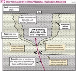
Since hydrocarbons are typically the last fluid to migrate into hydrothermal traps,15 it is plausible that hydrocarbons are generated in a “baked zone” surrounding the conduits accommodating hydrothermal fluid migration (Fig. 14).
The increased temperature would facilitate the localized generation of oil that would be proportional to the temperature and amount of hydrothermal fluid, the organic content of surrounding host rocks, and the aperture and density of fracture zones. The generated hydrocarbons would then migrate into the fluid pathway and up-section into the highest suitable structural or stratigraphic trap.
The inferred lag time between hydrocarbon sourcing and migration into the HTD traps would explain the presence of bitumen in vugs and the lack of oil inside Tennessee’s MVT deposits that have had early-stage quartz, pyrite, or calcite cementation.15 27
Preferential dolomitization
Why hydrothermal fluids preferentially dolomitize certain units and not others is still unresolved.14
MVT and HTD deposits require a hydrothermal fluid source, conduit, suitable reservoir, seal, and source of ions (Mg to form dolomite). This generalization, however, does not explain why certain carbonate units in the Knox Group and other horizons below known MVT deposits are not dolomitized, because they appear to be ideal hosts and were closer to the dolomitizing fluid source.
Principal HTD horizons in the Appalachian region are located in Cambrian and Ordovician rocks and have a large size range. Therefore, a single model will not account for all the chemical, stratigraphic, geologic, and temporal variables that control emplacement of MVT deposits and possible hydrocarbon migration.
Basinwide correlations
It has been demonstrated that the Middle Ordovician lithofacies in the southern Appalachian basin can be correlated into the Central Basin (from southern Tennessee to southern Ohio) with little difficulty.
The only facies that does not correlate well is the Lebanon limestone-Oregon dolomite because of probable regional dolomitization of the Lebanon limestone in east-central Kentucky. It is known that the Middle Ordovician carbonates are similar in Canada and New York,29 and recent studies have correlated lithofacies into the northern Appalachian basin.30
If these correlations could be verified in the subsurface between New York and Kentucky, it would indicate that a standard nomenclature should be established. It would be beneficial to use the most widespread nomenclature (Trenton-Black River Groups) and subdivide it using Wilson’s lithofacies.1
Using this convention, the Nashville-Lexington and Stones River-High Bridge Groups nomenclature would be replaced by Trenton-Black River. This would help in the transfer of ideas, information, and data across state boundaries.
Acknowledgments
We thank Brandon Nuttall and Dave Harris from the Kentucky Geological Survey, Kula Misra and Jen Whisner from the University of Tennessee, and Rick Schrantz from the Kentucky Paleontological Society for assistance with this research. We also thank Bill Dunne, Linda Kah, and Ken Orvis for constructive comments. This research was supported by the Science Alliance, a UT Center for Excellence, and the UT Department of Earth and Planetary Sciences, and the US Department of Energy grant DE-FC26-02NT15341.
References
- Wilson, C.W., Jr., and Stearns, R.G., “Structure of the Cumberland Plateau, Tennessee,” GSA Bull., Vol. 69, 1958, pp. 1,283-96.
- Rodgers, J., “The tectonics of the Appalachians,” Interscience Publishers, New York, 1970, 271 p.
- Roeder, D., Yust, W.W., and Little, R.L., “Folding in the Valley and Ridge province of Tennessee,” American Journal of Science, Vol. 279, 1978, pp. 477-496.
- Miller, R.L., and Fuller, J.O., “Geology and oil resources of the Rose Hill district-the fenster area of the Cumberland overthrust block-Lee County, Virginia,” Virginia Geological Survey, Bull. 71, 1954, 383 p.
- Clendening, J.A., and McCown, M.W., “Swan Creek field: Potential giant develops in Tennessee,” OGJ, Apr. 19, 1999, pp. 181-187.
- Hatcher, R.D., Jr., Williams, R.T., and McCown, M.W., “Swan Creek field: Isolated success or tip of the iceberg?,” OGJ, Oct. 1, 2001, p. 38-44.
- Born, K.E., and Burwell, H.B., “Geology and petroleum resources of Clay County, Tennessee,” Tennessee Division of Geology, Bull. 47, 1939, 188 p.
- Harris, L.D., and Milici, R.C., “Characteristics of thin-skinned style of deformation in the southern Appalachians, and potential hydrocarbon traps,” US Geological Survey Professional Paper 1018, 1977, 40 p.
- Whisner, J.B., and Hatcher, R.D., Jr., “Detachment folds and triangle zones: Unexplored hydrocarbon potential along eastern Cumberland escarpment, Tennessee,” OGJ, July 2003, pp. 38-44.
- Epstein, A.G., Epstein, J.B., and Harris, L.D., “Conodont color alteration-An index to organic metamorphism,” US Geological Survey Professional Paper 995, 1977, 27 p.
- Obermajer, M., Fowler, M.G., and Snowdon, L.R., “Depositional environment and oil generation in Ordovician source rocks from southwestern Ontario, Canada,” organic geochemical and petrological approach, AAPG Bull., Ohio, OGJ, Nov. 26, 1984, pp. 121-126.
- Coogan, A.H., and Parker, M.M., “Six potential trapping plays in Ordovician Trenton limestone, northwestern Ohio,” OGJ, November 1984, pp. 121-126.
- Keith, B.D., and Wickstrom, L.H., “The Lima-Indiana trend; reservoir characterization,” AAPG Bull., Vol. 75, 1991, p. 606.
- Oliver, J., “Fluids expelled tectonically from orogenic belts: Their role in hydrocarbon migration and other geologic phenomena,” Geology, Vol. 14, 1986, pp. 99-102.
- Misra, K.C., Gratz, J.F., and Lu, C., “Carbonate-hosted Mississippi Valley type mineralization in the Elmwood-Gordonsville deposits, central Tennessee zinc district: A synthesis,” in Sangster, D.F., ed., “Carbonate hosted lead-zinc deposits,” Soc. of Economic Geologists, Spec. Pub. No. 4, 1996, pp. 58-73.
- Wilson, C.W., Jr., “Pre-Chattanooga stratigraphy in central Tennessee,” Tennessee Div. of Geology, Bull. 56, 1949, 415 p.
- Evenick, J.C., and Hatcher, R.D. Jr., “Geophysical log characteristics for subdividing the Nashville (Trenton) and Stones River (Black River) Groups beneath the southern Cumberland Plateau in Tennessee and southern Kentucky,” Tennessee Div. of Geology, Report of Investigations No. 52, 2006, 12 p.
- Walker, K.R., Shanmugam, G., and Ruppel, S.C., “A model for carbonate to terrigenous clastic sequences,” GSA Bull., Vol. 94, 1983, pp. 700-712.
- Quinlan, G.M., and Beaumont, C., “Appalachian thrusting, lithospheric flexure, and the Paleozoic stratigraphy of the eastern interior of North America,” Canadian Journal of Earth Science, Vol. 21, 1984, pp. 973-996.
- Wickstrom, L.H., “Play MOf; Middle Ordovician fractured carbonates,” in Roen, J.B., and Walker, B.J., eds., “The atlas of major Appalachian gas plays,” West Virginia Geological and Economic Survey, 1996, pp. 172-176.
- Baranoski, M.R., Riley, R.A., and Wolfe, M.E., “Play ЄOk; Cambrian-Ordovician Knox Group unconformity play,” in Roen, J.B. and Walker, B.J., eds., “The atlas of major Appalachian gas plays,” West Virginia Geological and Economic Survey, 1996, pp. 181-187.
- Nuttall, B. C., “Play Obc; Middle and Upper Ordovician bioclastic carbonate (“Trenton”) play,” in Roen, J.B., and Walker, B.J., eds., “The atlas of major Appalachian gas plays,” West Virginia Geological and Economic Survey, 1996, pp. 168-171.
- Von Rudloff, T., Talisman Energy, personal communication, 2005.
- Black, D.F.B., MacQuown, W.C., and DeHaas, R.J., “The relation of dolomite associated with faults to the stratigraphy and structure of central Kentucky,” US Geological Survey Professional Paper 1151-A, 1981, 19 pp.
- Harris, D.C., Wilcox, C.A., and Parris, T.M., “Analogs for fault-controlled Ordovician dolomite reservoirs, Appalachian basin: Characterization of central Kentucky outcrops,” AAPG meeting abs., 2005, p. A58.
- Bailey, J.R., Evenick, J.C., Hatcher, R.D., Jr., and Weyland, H.V., “Possible hydrothermal dolomite reservoir(s) in the Swan Creek field, Tennessee,” AAPG Bull., Vol. 89, 2005, Eastern Section meeting abs., p. 16.
- Smith, F., Elmwood mine (PASMINCO), personal communication, 2004.
- Wilcox, C.A., “Origin and geochemistry of tectonic dolostone bodies in central Kentucky,” University of Kentucky, Lexington, MS thesis, 2005, 191 p.
- Patchen, D.G., Avary, K.L., and Erwin, R.B., “Correlation of stratigraphic units of North America (COSUNA) project,” AAPG, Southern Appalachian Region, Chart 1985.
- Brett, C.E., McLaughlin, P.I., Cornell, S.R., and Baird, G.C., “Comparative sequence stratigraphy of two classic Upper Ordovician successions, Trenton shelf (New York-Ontario) and Lexington platform (Kentucky-Ohio): Implications for eustasy and local tectonism in eastern Laurentia,” Palaeogeography, Paleoclimatology, Paleoecology, Vol. 210, 2004, pp. 295-329.
Bibliography
Schruben, P.G., Arndt, R.E., and Bawiec, W.J., “Geology of the conterminous United States at 1:2,500,000 Scale-A digital representation of the 1974 P.B. King and H.M. Beikman Map,” US Geological Survey, Digital Data Series 11, Release 2, 1998.
