APPALACHIAN NOMENCLATURE-1: Trenton-Black River could replace older Mid-Ordovician names in S. Appalachians
The Middle Ordovician carbonate platform facies and petroleum system (Nashville-Stones River or Trenton-Black River Groups) are currently the most active hydrocarbon plays in eastern North America.
The facies are recognizable at the surface on the Nashville and Jessamine domes and can be traced using geophysical well log signatures from central Tennessee eastward beneath the Cumberland Plateau into Kentucky, Virginia, and the western Valley and Ridge of Tennessee.
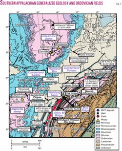
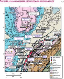
The Cumberland Plateau contains the western limit of deformation in the Appalachian overthrust region but is otherwise characterized by strata dipping gently southeastward from the Nashville and Jessamine domes (Fig. 1).1-3 The Nashville-Stones River Groups are proven oil and gas reservoirs in the Highland Rim, Plateau, and Valley and Ridge.
Major producing fields exist in Overton and Pickett counties, Tennessee, and Clinton and Wayne counties, Kentucky, in the eastern Highland Rim. Rose Hill and Swan Creek fields are productive oil and gas fields in the thrust belt of southwestern Virginia and northeastern Tennessee.4-6 Future exploration in the region is attractive because of the presence of both stratigraphic and structural traps,7-9 shallow drilling depths, and reservoirs that may be self-sourcing.10 11
Hydrothermal dolomite (HTD) plays have become an increasingly prominent exploration target in the southern Appalachians and are difficult to identify in the subsurface with conventional technology.
Large, known HTD fields in the Michigan and Illinois basins (i.e., Albion-Scipio and Lima-Indiana trends) and smaller, productive fields in the northern Appalachian basin (i.e., Glodes Corners Road field, New York) have demonstrated that these are excellent reservoirs and petroleum targets.12 13 Consequently, interest has been growing in the southern Appalachian basin in the potential of similar HTD plays.
While it is difficult to identify and prospect these targets for hydrocarbons, the interest is justified because major Mississippi Valley Type (MVT) zinc deposits have been mined for decades in Tennessee and southwestern Virginia. Large amounts of data on HTD are available as a result of mining and prospecting these deposits.14 15
Mining MVT deposits in Tennessee (Elmwood-Gordonsville, Mascot-Jefferson City, and Copper Ridge districts) and Virginia (Austinville district) generated a large amount of information on mineral paragenesis, pressure and temperature estimates, and mineralization horizons.15 This information is important not only to future MVT hydrocarbons prospecting in the region but also to regional HTD exploration.
Stratigraphy
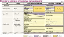
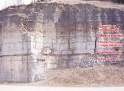
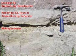
The Middle Ordovician sequence has been subdivided into nine lithostratigraphic units on the surface that have been recognized in the subsurface beneath the Highland Rim, Cumberland Plateau, and western Valley and Ridge (Figs. 2-5).16 17
null
null
null
null
These lithofacies extend into the Valley and Ridge to the footwall of the Clinchport-Whiteoak Mountain-Wallen Valley thrust system (Fig. 6). East of the thrust system, a thin platform carbonate bank facies changes from a thinned, bank-edge facies, to a very thick siliciclastic basin facies to the east of the Saltville fault.18 The thinning carbonate facies mark the approximate western edge of the foreland basin.18 19
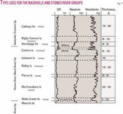
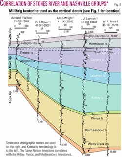
Geophysically subdividing the Nashville-Stones River Groups into the known formations is readily achievable in the southern Appalachian basin (Figs. 7 and 8),17 and doing so enhances the success in identifying possible structures, potential pay horizons, and traps.
null
While large log suites exist for some of the deeper tests, the most commonly available log useful for stratigraphic correlation is the gamma-ray log. Gamma-ray signatures of Nashville-Stones River Groups units are commonly diagnostic.
The discontinuous Wells Creek formation, if present, has irregular gamma-ray amplitudes over 80 API units. The Murfreesboro limestone has an irregular gamma-ray signature that ranges in amplitude from 20 to 80 API units.
The Pierce limestone is around 30 ft thick and bounded by two prominent shaly limestone sections16 that have gamma-ray signatures with amplitudes of 60 to 70 API units. The massive Ridley limestone has a low amplitude and an almost flat gamma-ray signature of 20 to 30 API units.
Lebanon limestone is around 100 ft thick16 and, because of its mixed massive to thin-bedded and shaly character, has a heterogeneous gamma-ray signature typically of 25 to 40 API units. The massive Carters limestone generally has a flat gamma-ray signature of 20 to 30 API units.17
The gamma-ray signature of the shaly-sandy limestone of the Hermitage formation (basal Nashville Group) is irregular and has amplitudes ranging from 60 to 80 API units with occasional spikes approaching 200 API units. The overlying, clean medium-bedded Bigby-Cannon limestone has a consistently flat and low amplitude gamma-ray signature of 20 to 30 API units.
The gamma-ray signature of the Catheys formation is higher in overall intensity (30 to 80 API units) and is very irregular, much like the Hermitage formation.17
Oil and gas reservoirs
The region west of the Clinchport-Whiteoak Mountain fault system lies in the oil/gas window.10
Recognition of the continuity in stratigraphy over this wide region is significant to future drilling in the southern Valley and Ridge Province because the Nashville-Stones River Groups are known hydrocarbon producers and comprise one or more petroleum systems.
Proved reserves have been found in Ordovician strata in Tennessee (i.e., Swan Creek and Flat Creek fields)5-7 20, Kentucky (i.e., Burning Springs and Albany Consolidated fields),20-22 and Virginia (i.e., Rose Hill and Ben Hur fields).4 20
The Bigby-Cannon limestone (Lower Sunnybrook horizon) and Murfreesboro are known oil-producing intervals, and the uppermost Knox Group (Mascot dolomite) is a prominent gas-producing zone.6 7 21
The enhanced ability to identify and target these intervals or reservoirs, therefore, could open the region to more exploratory drilling because drilling depths are shallower in the southern Appalachian basin and because large, unexplored anticlinal plays such as the Eureka structure9 are present. In Overton County, Tennessee, possible HTD related sags are actively being prospected.
HTD traps
HTD structures in the Appalachian basin have a number of similarities, yet, the stratigraphic horizons where HTD structures have been found vary regionally.
In the MVT mining districts of Tennessee, HTD structures occur in the Kingsport formation and Mascot dolomite (Upper Knox Group) and Murfreesboro limestone (Lower Stones River-Black River Group)15
In central New York, 300 ft of the Upper Black River Group is pervasively hydrothermally dolomitized.23
In Kentucky, HTD structures have been found only in the Lexington (Trenton) Group but not in the Upper High Bridge (Black River) Group.24
A recent test core drilled by the Kentucky Geological Survey into the largest known outcropping HTD structure (sometimes called “light bulb” or “dolomite chimney” structures) indicates that dolomitization decreases with depth and does not appear to be directly related to the proximity of the fault zone thought to have served as the conduit for hydrothermal fluids.25
An exposed HTD structure in Kentucky suggests that dolomitizing basal fluids migrated up-section through a small thrust fault and dolomitized around the tip of the fault causing the circular structure.
It is likely that future prospecting in the region will identify additional HTD structures in Kentucky and Tennessee. It is also probable that producing fields have not been accurately identified as being related to HTD structures where a well or field with anomalously high porosity could be on the flanks of an unknown structure.
A small, productive HTD structure has recently been postulated, although unconfirmed, to exist in part of Swan Creek field in the Upper Carters limestone (Upper Stones River Group).26 The thickness of this weakly dolomitized section is only a few feet, but it may be responsible for the best oil production in the field.26
Production data from this possible HTD structure indicate that these plays can be significant (>300 b/d of oil) but that production may last only days or months.
Next: Using Trenton-Black River instead of existing nomenclature could aid in the transfer of exploration ideas, information, and data across state lines.
The authors
Jonathan C. Evenick ([email protected]) is a postdoctoral research assistant at the University of Tennessee-Knoxville. He has been working on exploration and geologic model for the southern Appalachian basin and stratigraphic complexities in the Sevier basin. He has a PhD from the University of Tennessee.
Robert D. Hatcher Jr. ([email protected]) is a distinguished scientist and professor at the University of Tennessee-Knoxville. He is a structural/tectonics geologist who has worked for more than 35 years in the Appalachians after spending a year in New Orleans with the former Humble Oil & Refining Co. (now ExxonMobil Corp.). The National Science Foundation, Department of Interior, US Department of Energy’s National Petroleum Technology Office, and private industry support his research.
