Afghan resource assessment fed positive outlook for exploration
A research team recently estimated mean volumes of undiscovered conventional recoverable hydrocarbons in northern Afghanistan at 1.596 billion bbl of crude oil, 15.687 tcf of gas, and 562 million bbl of natural gas liquids.
Using a geology-based assessment methodology, the US Geological Survey-Afghanistan Ministry of Mines & Industry Joint Oil and Gas Resource Assessment Research Team made the estimate.
Most of the undiscovered crude oil is in the Afghan-Tajik basin part of northern Afghanistan, and most of the undiscovered natural gas is in the Amu Darya basin part of northern Afghanistan.
Introduction
Crude oil, natural gas, and natural gas liquids/condensate (collectively called “petroleum”) resources are important for the redevelopment of Afghanistan’s infrastructure.
One of the results of more than two decades of strife in Afghanistan is a shortage or absence of energy required to improve living conditions. Food, clothing, shelter, heat, sanitation, and industrial development, in general, depend on the availability of energy.
The presence of petroleum resources has long been known in Afghanistan, but these resources were exploited only to a limited extent.
Improved living and economic conditions in Afghanistan require increasing the availability of energy, particularly by exploitation of Afghanistan’s petroleum resources.
The US Trade & Development Agency funded the USGS-Afghan assessment.
The assessment is based on the geologic elements of a total petroleum system, which include:
- Source-rock presence, maturation, petroleum generation, and migration.
- Distribution and quality of reservoir rocks.
- Presence of seal rocks.
- Character of traps and time of formation with respect to petroleum migration.
Data from detailed studies of geochemistry, petroleum geology, geophysics, and tectonics combined with historical exploration and production analyses were used to aid in the estimation of the number and sizes of undiscovered petroleum accumulations.
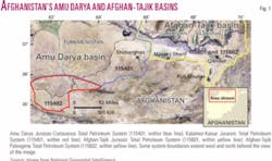
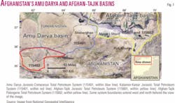
Much of the petroleum resource potential of Afghanistan and all of the known crude oil and natural gas reserves are in northern Afghanistan, located in parts of two petroliferous geologic basins, the Amu Darya basin to the west and the Afghan-Tajik basin to the east (Fig. 1).
The two basins encompass approximately 86,700 sq km (33,500 sq miles) in those portions that lie within Afghanistan.
Although the area has been explored, both the Amu Darya and Afghan-Tajik basins of northern Afghanistan are shown in this study to have potential for additional crude oil and natural gas discoveries.
The area with the greatest potential for undiscovered natural gas accumulations is in Upper Jurassic carbonate and reef reservoirs postulated to lie beneath an impermeable salt layer in relatively unexplored parts of northern Afghanistan.
The area with the greatest potential for undiscovered crude oil accumulations is in Cretaceous to Paleogene carbonate reservoir rocks associated with thrust faulting and folding in the Afghan-Tajik basin of northeastern Afghanistan.
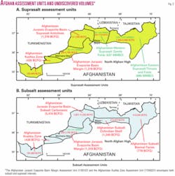
Four total petroleum systems are identified, and these were subdivided into eight assessment units for the purpose of resource assessment (Figs. 1 and 2).
Geologic provinces
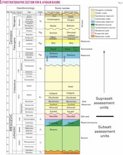
Pre-Neogene stratigraphy of the Amu Darya and Afghan-Tajik basins is similar, consisting of a Paleozoic to Triassic basement complex, a Jurassic to Paleogene platform, and Neogene to Quaternary orogenic cover (Fig. 3).
The basement complex is composed of continental and oceanic blocks of strongly deformed and partially metamorphosed sedimentary rocks that were accreted during Upper Paleozoic (Hercynian) tectonism.
The Triassic section is comprised of marine carbonate and clastic rocks, and volcanic rocks, which pass into continental redbeds. These rocks fill grabens in the basement and are themselves considered an economic basement for petroleum.
The Mesozoic to Paleogene platform is divided into four intervals:
- Lower to Middle Jurassic terrigenous coal-bearing clastic rocks.
- Upper Middle to Upper Jurassic marine carbonate and evaporite rocks.
- Terrigenous Lower Cretaceous clastic rocks and redbeds.
- Upper Cretaceous to Paleogene marine carbonate and clastic rocks.
Collision of the Indian plate with Asia in late Oligocene time and protrusion of the Pamir block northward resulted in compression and formation of anticlinoria and synclinoria in the Afghan-Tajik basin. Upper Jurassic evaporite rocks form a detachment surface for thrust faulting and folding.
Only moderate uplift of structural blocks and formation of local anticlines occurred in the Amu Darya basin as a result of the compressional event. Thick orogenic sediments were deposited during late Neogene and Quaternary time, up to 5,000 m in the Afghan-Tajik basin but with decreasing thickness westward into the Amu Darya basin.
Total petroleum systems
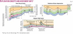
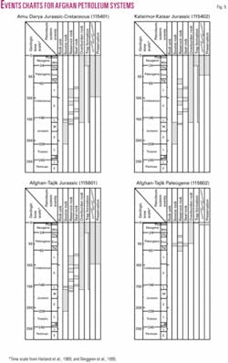
Four total petroleum systems are identified and subdivided into eight assessment units for the purpose of resource assessment (Figs. 4 and 5).
Three total petroleum systems are parts of a once single pre-Neogene total petroleum system located mainly in the Amu Darya basin but extending into the Afghan-Tajik basin.
Jurassic source rocks charged predominantly carbonate reservoirs with natural gas below a thick (as much as 800 m) salt seal. Clastic reservoirs of Cretaceous age (above the Jurassic section) are charged with natural gas and crude oil where the salt is absent. A younger Paleogene total petroleum system overlies the Jurassic system in the Afghan-Tajik basin. There, the Jurassic and Paleogene total petroleum systems are separated by thick Jurassic salt in thrust-fault sheets. The Paleogene total petroleum system is oil-prone.
Elements of the Amu Darya Jurassic and the Afghan-Tajik Jurassic Total Petroleum Systems include Lower to Middle Jurassic carbonaceous mudstone and coal and Upper Jurassic basinal marine mudstone source rocks, Upper Jurassic carbonate and Lower Cretaceous clastic reservoirs, Upper Jurassic evaporites (salt and anhydrite) and Lower Cretaceous mudstone seals, and Mesozoic and Cenozoic structures and reef-related features as traps (Figs. 4 and 5).
The third, Kalaimor-Kaisar Jurassic Total Petroleum System, includes only Lower to Middle Jurassic carbonaceous mudstone and coal source rocks; Lower to Middle Jurassic and Lower Cretaceous clastic reservoirs and Upper Cretaceous carbonate reservoirs; intraformational Jurassic, Cretaceous, and Paleogene mudstone seals; and Mesozoic and Cenozoic structures as traps (Fig. 4).
The Paleogene Total Petroleum System had been previously poorly defined in the Afghan-Tajik basin because source rocks for crude oil in this basin had not been identified. This system is composed of Lower Eocene basinal marine mudstone source rocks, Upper Cretaceous to Paleogene reservoirs, Lower Eocene and Upper Paleogene mudstone seals, and Neogene compressional structures associated with Himalayan orogenesis as traps (Fig. 4).
Local mixing of Jurassic-sourced petroleum with Paleogene-sourced petroleum is possible in areas where Jurassic salt is absent (evacuated by deformation). Anticlinal structures in the eastern part of the basin are eroded and some breached, resulting in biodegradation and leakage of petroleum.
Assessment units
The four total petroleum systems are subdivided into units with homogeneous geologic traits and exploration efforts that include sufficiently homogeneous field-size populations for resource assessment. All eight assessment units are located in Afghanistan.
Amu Darya basin
Assessment units in the Amu Darya basin part of Afghanistan are defined by stratigraphic position above or below the Upper Jurassic salt (Fig. 4).
The Afghanistan Jurassic Evaporite Basin Subsalt Carbonates Assessment Unit (11540105) encompasses Upper Jurassic carbonate and probable reef reservoirs below the salt seal. This assessment unit has higher potential for undiscovered natural gas resources than other assessment units.
The Afghanistan Jurassic Evaporite Basin Suprasalt Anticlines Assessment Unit (11540106) encompasses predominantly Cretaceous sandstone reservoirs associated with anticlinal structures above the salt seal. This assessment unit has relatively low potential for undiscovered petroleum resources because of unfavorable conditions for migration of petroleum.
The Afghanistan Jurassic Evaporite Basin Margin Assessment Unit (11540107) is located where Jurassic salt is absent and most of the petroleum is contained in Cretaceous sandstone reservoirs (Fig. 4). This assessment unit is the most explored and contains the greatest number of known accumulations and volumes of discovered crude oil and natural gas.
The Afghanistan Kushka Zone Assessment Unit (11540201) encompasses the entire Kalaimor-Kaisar Jurassic Total Petroleum System within Afghanistan (Fig. 4) and involves Lower to Middle Jurassic sourced natural gas reservoired in Jurassic, Cretaceous, and Paleogene units.
Afghan-Tajik basin
In addition to the position above or below the Upper Jurassic salt, assessment units in the Afghan-Tajik basin part of Afghanistan are further defined by the degree of structural deformation (Fig. 4).
Two assessment units are defined below thrust sheets and the Jurassic salt. The Afghanistan Subsalt Oxfordian Shelf Assessment Unit (11560101) encompasses reservoirs of carbonate and clastic rocks deposited on a shelf along the south margin of the Afghan-Tajik basin and structures that developed before Neogene thrust faulting and folding.
Reservoir rocks of the Afghanistan Subsalt Basinal Facies Assessment Unit (11560102) are more argillaceous than those deposited on the shelf, are buried to greater depths, and have low potential for petroleum accumulations.
The Afghanistan Western Suprasalt Gentle Folds Assessment Unit (11560201) and the Afghanistan Eastern Suprasalt Thrusts and Folds Assessment Unit (11560202) are both stratigraphically positioned above the Upper Jurassic salt but differentiated with respect to the intensity of deformation within potential structural traps.
The Afghanistan Western Suprasalt Gentle Folds Assessment Unit is located on a basement structural step that inhibited intense Neogene deformation thereby having larger, unbroken structures with a high potential for crude oil resources.
Resource summary
The greatest volume of undiscovered crude oil is estimated to be in the Afghanistan Eastern Suprasalt Thrusts and Folds Assessment Unit (11560202) (Fig. 2).
The greatest volume of undiscovered natural gas is estimated to be in the Afghanistan Jurassic Evaporite Basin Subsalt Carbonates Assessment Unit (11540105) (Fig. 2).
Further information
Supporting geologic studies of total petroleum systems and assessment units and reports on the methodology used in the North Afghanistan petroleum resource assessment are in progress. Assessment results are available at the USGS Central Energy Team web site (http://energy.cr.usgs.gov/oilgas/).
The authors
Tim Klett is a research petroleum geologist at the US Geological Survey, where he is responsible for the assessment of undiscovered petroleum resources worldwide. Before joining the USGS in 1991, he worked as a mud logger and in 1984 joined Exxon Production Research Co. (now ExxonMobil Research Co.). He has a PhD in geology/geochemistry from the Colorado School of Mines.
C.J. Wandrey is a petroleum geologist and World Energy Project Regional Coordinator for South Asia with the USGS in Denver. He has participated in USGS oil and gas assessments and regional petroleum geology studies in the US and South Asia for 20 years. Recent work includes oil and gas assessments of the Kohat-Potwar, Indus, Assam, Kutch, Cambay, Bombay, Central Burma, and Andaman basins.
Gregory F. Ulmishek was a research geologist with the USGS in Denver for 20 years. He is currently an exploration geologist with Direct Petroleum Co. in Denver. After 20 years as an exploration and research geologist in the former USSR, he immigrated to the US in 1980 and was employed by the Argonne National Laboratory. After joining the USGS in 1987, he coordinated geologic studies and petroleum resource assessments in the Former Soviet Union and Arctic sedimentary basins. He has an MS in geology from the Moscow Petroleum Institute and a PhD from the Institute of Geology and Exploration for Fossil Fuels.
Abdulla Amirzada is a petroleum geologist. He has worked on the petroleum geology of the Amu Darya and Afghan-Tajik basins for more than 25 years and is presently the President of Oil and Gas at the Afghanistan Ministry of Mines and Industry.
