Satellite data finding more uses in E&D, other industry segments
Pierre-Philippe Mathieu
European Space Agency
Rome
One of the biggest challenges the oil and gas industry faces today is to extract the natural resources locked into the ground while minimizing cost and the impact on the environment.
Meeting this challenge requires accurate and timely information on the environmental and operating conditions of oil and gas activities in order to aid decision-making. The traditional way to gather these data has been through field surveys. This approach is, however, very costly and resource intensive and can only provide local measurements.
By contrast, remote sensing from space-referred to here as Earth Observation (EO) data-offers an attractive and competitive approach to deliver the global, consistent data sets needed to support oil and gas operations.
Today, more than 50 EO satellites are in orbit and continuously monitoring the state of the planet, including the ocean, atmosphere, ice sheets, and vegetation.
By sensing electromagnetic radiation across the whole spectrum, satellites can infer environmental information, sometimes invisible to the eye, about the weather conditions, oil seep, vegetation cover, soil moisture, chemical composition of the atmosphere, heat radiation of soil, subsurface geology, sea elevation, and land deformation to accuracies measured in millimeters.
By exploiting the unique vantage point of space, satellites are able to capture a synoptic view of the earth (e.g., bird’s-eye view) and to monitor remote and difficult-to-access regions where no survey data exist or are possible to obtain (e.g., poles, deserts).
The ability to retrieve historical EO data from the satellite archive is also a crucial advantage to allow detection of changes in the environment. However, although they present major advantages, satellite measurements also suffer from limitations inherent to the remote sensing technology in terms of sampling (e.g., limited temporal and spatial resolution, inability of optical sensors to see through clouds) and validation (e.g., difficulty of interpretation of indirect measurements). These limitations of EO data can only be overcome by combining EO data with in situ measurements, which provide the ground truth necessary for validation.
Similar to the process of refining crude oil to make it useful, raw EO data need to be turned into information (i.e., tailored to the needs of decision-makers) to be deemed valuable. This data-to-information conversion process is not an easy task and often requires integration of EO with ancillary data (e.g., GPS, in situ surveys) and traditional knowledge into a geographical information system (GIS).
Such EO-based information services provide engineers with a powerful tool to support sound decision-making in many aspects of the oil and gas industry, ranging from exploration, extraction, operation, due diligence study, and remediation.
This article contains five examples of EO-based information services assisting oil and gas exploration, exploitation, and transport activities offshore and onshore. These examples are derived from actual test cases supported by the “Earth Observation Market Development” (EOMD) program of the European Space Agency (ESA).
The EOMD program aims to foster the use of EO-based information services in business practices by building partnership between small value adding companies specialized in EO and large downstream companies that require geo-information, such as Shell, BP, AGIP, AMEC, WesternGeco, and Fugro. More information on EOMD and associated EO application projects is available (www.esa.int/eomd).
Satellite remote sensing’s contribution is likely to grow with the new generation of satellites that provide enhanced spectral, temporal, and spatial capabilities (e.g., hyperspectral and gravity missions will enable scientists to map geological conditions with unprecedented accuracy.)
Optimizing seismic surveys
Seismic surveying is by far the most important tool the oil and gas industry uses to build a complete picture of subsurface geology.
Today, the most sophisticated technique for accurate seismic surveys is the patented Vibroseis method. The accuracy of this method, however, comes with a significant cost. A survey of a 500 sq km area can require more than 400 people with as many as 50 small and 15 large vehicles working with up to 600,000 geophones and carrying out 600 seismic shots/day.
One of the issues of seismic surveyors is to maximize the signal-to-noise ratio by ensuring a good coupling between the emitters and receivers. To do so, it is advised not to place trucks atop very hard rock (e.g., basalt acts as a massive reflector) or geophones above rocks that acoustically distort the signal.
EO can assist this process by characterizing, at small cost and prior to the survey, the region’s topography (e.g., elevation), roughness (e.g., vegetation and soil cover) and subsurface geological and lithological characteristics (e.g., presence of massive reflector such as basalt). This information can then be used to assess areas that will produce the best seismic surveys and to optimally place emitters and receivers.
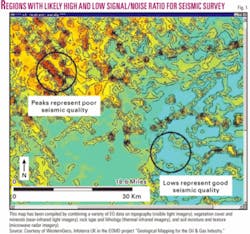
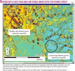
WesternGeco, the world’s largest seismic surveying company, is using EO data in Argentina and Algeria to help focus fieldwork planning (Fig 1). Andreas Laake, product champion at WesternGeco, said EO “represents for us a means of carrying out seismic survey feasibility studies prior to defining survey programmes for our clients, and ensuring enhanced data quality for even the most challenging environments.”
Land drilling support
Extracting oil from the ground can lead to severe subsidence due to reservoir depletion and compaction.
This is the case at supergiant Belridge oil field, one of the largest in the US, where subsidence of as much as 50 cm/year has led to serious well failures that cost more than $20 million/year in reparation.
Until now, well engineers have relied on GPS surveys to monitor ground deformation. Although quite accurate, this method is resource intensive (e.g., data processing) and can only provide an incomplete point-based picture of the subsidence issue.
Today, minute motions of the earth’s surface can be monitored from space within millimeters accuracy thanks to a powerful surveying technology called Interferometry of Synthetic Aperture Radar images (INSAR).
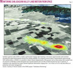
The INSAR technique is now used operationally at Belridge to monitor every month the deformation around the well within a few days of satellite pass and decide how much water to inject in order to offset ground subsidence (Fig. 2). This cost-effective technology provides a two-dimensional overview of subsidence, which compliments local level ground measurements and helps engineers to quickly identify problem areas.
David Mayer, reservoir engineer, said the Belridge operator “uses INSAR data constantly for making decisions on how to draw wells and operate the field” because INSAR gives the true picture of subsidence with great accuracy.
Deepwater drilling
Oil and gas exploitation in the Gulf of Mexico has enormous potential, but deepwater drilling operations are plagued by the presence of eddies, the marine equivalent of hurricanes, that spin off from a large oceanic river called the “loop” current.
The loop current is formed when warm water from the Caribbean Sea enters the Gulf of Mexico through the Yucatan Straits and “loops” clockwise through the basin before exiting through the Florida Straits to merge with the Gulf Stream.
When approaching the Florida Straits, the loop current bends strongly, becomes unstable, and therefore releases energetic warm core eddies (with a typical size of 100 km) into the northern waters of the Gulf of Mexico populated with platforms and rigs. Eddies generally have strong associated currents that can significantly disrupt offshore exploration, development, construction, and production operations.
An eddy called “Sargassum,” named for the Sargasso Sea, traveled through a heavily exploited sector in 2003 and caused millions of dollars of damage. More recently, Hurricane Katrina highlighted the strategic importance of the gulf’s oil and gas production on the world economy. Monitoring of eddies in the gulf is of vital importance to ensure safe, cost effective, and environmentally responsible decision-making for offshore operations.
Until now, the industry has relied heavily on the deployment of satellite-tracked surface drifters to monitor the behavior of the loop current and associated eddies in relation to the locations of offshore installations. However, this approach remains costly and can only provide an incomplete, point-based picture.
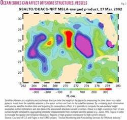
Today, space-based monitoring can provide a cost-effective alternative early warning system of eddies. Altimeters on board satellites orbiting at 800 km can measure the ocean height along the satellite path to within a few centimeters. By combining altimeter measurements from several satellites with advanced hydrodynamic modeling techniques, it is possible to create synoptic and detailed maps of sea-surface height that show in near-real time eddies detaching from the main current (Fig. 3).
Fugro GEOS subsidiary Ocean Numerics works closely with major US operators in the use of this technique. Results are extremely encouraging, said Robin Stephens, a director of Ocean Numerics Ltd., “Recent advances in numerical modeling and satellite data processing techniques are resulting in the ability to locate eddies accurately and to predict their separation from the loop current and propagation towards areas of intense deepwater oil and gas activity.”
Monitoring pipelines
It is extremely challenging to monitor buried pipelines.
Traditional monitoring methods include “flying the line” in aircraft and the deployment of ground-based measurements. These methods are costly and not always feasible (e.g., remote areas, weather conditions, political problems). They also suffer from the safety concerns.
Today, EO provides pipeline operators with an improved monitoring capability to manage pipeline integrity and environmental impact, without leaving the office, and at a cost often less than a visit to the site.
EO can provide a rapid, frequent, and up-to-date picture of topographic constraints (e.g., digital elevation model), terrain conditions (e.g., land cover, infrastructure) and ground stability (e.g., INSAR-based motion map), thereby facilitating pipeline design and routing (even in remote sites), assessing risk areas (e.g., ground motion, third party encroachment), and detecting early pipeline stress while reducing cost by eliminating frequent on site inspections and providing more efficient preventive remedial measures.
Southern California Gas, a world leader in pipeline management, is using EO technology to monitor subsidence along its buried transmission pipelines that are subject to excessive strain. Mitigation measures, such as strain relief by excavation, can then be used if the risk of pipeline failure is high.
Rick Gailing, principal engineer, pipeline design at SoCalGas, said, “Satellite monitoring technology is an objective and rational tool that augments current pipeline engineering and operating practice by complementing conventional engineering methods such as theoretical analysis, numerical modeling, and in situ field monitoring programs. The EO technology will help streamline operating costs and enhance current monitoring capabilities, which will of course be of direct benefit to our company.”
Offshore ice hazards
Offshore extraction of oil at the Hibernia and Terra Nova platforms on the Grand Banks off Canada’s east coast accounts for more than 40% of the country’s total production, and the volume is increasing with the recent startup of production from Whiterose field.
One of the biggest challenges for oil extraction in the ice infested waters off Newfoundland known as iceberg alley is to operate platforms in the presence of drifting icebergs. Icebergs can damage well infrastructure on the ocean floor, causing environmental damage and costly interruptions to production.
To prevent these situations from occurring, icebergs are managed by either towing or pushing them. This operation is time consuming and resource intensive (e.g., requiring several vessels). If detection of a threatening iceberg is not achieved early enough for effective towing or deflection, then the last resort is to cease oil production or, in extreme cases, evacuate the platform, which is both hazardous and expensive. Therefore, there is a strong need to reliably detect icebergs a considerable distance from the oil and gas production areas, well beyond the conventional radar horizon.
During ice season, the Grand Banks is generally characterized by considerable fog, cloud, and precipitation, thereby precluding effective visual detection, and thus leaving radar-based systems as the primary surveillance tool.
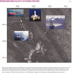
Space-based SAR plays a significant role in iceberg detection and effective iceberg management. By supplementing existing aerial surveillance with regular and reliable SAR acquisitions farther upstream from the production facilities, space-based monitoring provides the engineers with a “look into the future,” thereby complementing the suite of surveillance tools for monitoring icebergs 24 hr/day in all weather conditions (Fig. 4).
Petro-Canada, the company that operates the Terra Nova platform and is part owner of Hibernia and Whiterose, uses these EO surveillance technologies to help improve ice reconnaissance in the Grand Banks. Jason Kean, White Rose lead engineer at Petro-Canada, expressed the need for increased focus on the development of systems capable of effectively detecting icebergs over wide areas. ✦
The author
Pierre-Philippe Mathieu ([email protected]) is an earth observation applications engineer in the Earth Observation Science & Applications Department of the European Space Agency in the Rome suburb of Frascati, Italy. He has worked 10 years in environmental modeling, weather risk management, and remote sensing. He has a degree in mechanical engineering and MSc from University of Liege, a PhD in oceanography from the University of Louvain, and a management degree from the University of Reading Business School.
