Integrated approach recommends redevelopment plan
Redevelopment recommendations for a mature oil field off Egypt relied on an integrated approach. The field exhibited highly complex geological and reservoir characteristics.
The approach included:
- Collecting, evaluating, and analyzing reservoir data.
- Estimating reserves and determining the location of remaining oil.
- Integrating reservoir data and selecting proper techniques for improving the recovery factor such as drilling new wells or applying secondary or tertiary recovery methods.
The Shukheir Bay field is in shallow water close to the western coast of the southern part of Gulf of Suez and is about 20 km south of Gharib, Egypt.
Offshore Shukheir Oil Co. (OSOCO) operates the fields.
Field redevelopment
Redevelopment of mature oil fields is a subject that can be divided into two main parts: well and reservoir redevelopment Depending on the field type, history, and prospects, the redevelopment plans could include work on either or both parts.1
A successful reservoir development plan depends on analyzing and integrating the available data from geology, geophysics, and reservoir engineering.2 Putting together the plan is both an art and skill as well as a science.3 For the complex problem of developing a hydrocarbon resource, no short cuts or easy numerical solutions exist that adequately substitute for skill, experience, and vision.
Development and depletion strategies depend on the life-cycle of a reservoir. In a new discovery, the plan needs to address how best to develop the field, including well spacing, well configuration, and recovery scheme. If the reservoir has been depleted by primary means, the plan needs to investigate secondary and tertiary recovery schemes.4
Data analysis is not easy but is extensive because all of the field data (seismic, geological, coring, logging, pressure-volume-temperature (PVT) behavior, well tests, and production operations) need to be collected, reviewed, and evaluated.
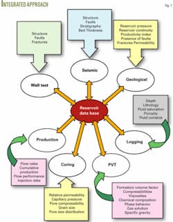
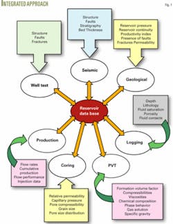
The data-analyses step provides a picture of the accumulation for obtaining a better understanding of the reservoir geometry, rock properties, phase behavior, fluid properties, and flow characteristics. Fig. 1 shows different sources for the data needed in creating a reservoir development plan.
Reserves estimates combine science and art-science because the estimates calculate reserves from various parameters and an art because exact values of the parameters and their variation across the reservoir are unknown.
Four ways for estimating reserves in mature reservoirs are:5
- Volumetric calculations.
- Material-balance calculations.
- Decline-curve analysis.
- Reservoir modeling.
Reserves estimation is a basic step in defining the most economical development strategy for a field. The estimation should include all available tools and skills for quantifying initial reserves in place and formulating an investment program that develops and produces those reserves in an economic manner.
The reserves determined affect the number of wells required to develop a field. Poor reserves estimates lead to poor economics that disappoint owners, operators, and investors.
The reservoir data come from a variety of sources and require integration along with the reserves estimation to produce a complete picture of the reservoir. Proper integration of the reservoir data adds significant value. By crossing the traditional boundaries and integrating the work of geoscientists and engineers, data resources are better utilized.
The process of integrating data is dynamic, not static; each data type is subject to change. The reservoir system is never known completely, but the knowledge becomes more complete as the reservoir matures.
The challenges are to know when to integrate and at what level the integration should take place? Unless the integration can better identify the reservoir properties for more accurate reservoir performance predictions of optimal hydrocarbon recovery, the integration may be meaningless.
Shukheir Bay field
Four deviated wells from shore developed the shallow-water Shukheir Bay field. Three (SHB-1, SHB-2, and SHB-4st) are Lower Rudies sand completions, while the fourth well (SHB-3st) is a Karim formation completion.
Initial production from Well SHB-1, completed on Lower Rudies Upper sand Pay I in December 1980, was 2,200 bo/d and 0.8 MMscfd gas.
Initial reservoir pressure was 2,470 psig, while the produced oil had a 2,241-psig bubblepoint pressure. Since December 1980, the main reservoir (Lower Rudies sands) has produced a cumulative of about 5 million bbl of 34° gravity oil from two pay zones (Pay I and Pay II) through two wells (Wells SHB-1 and SHB-4st).
Well SHB-2 was completed in an isolated dry zone.
Currently, the main producing well (Well SHB-1) is on a jet pump and produces about 700 bo/d with a 70% water cut and estimated 680 scf/bbl GOR.
The current reservoir pressure is about 1,800 psig.
A complete recent reservoir study for redevelopment of Shukheir Bay field included:
- Review, analysis, and integration of the data to provide more geological, engineering, and structural understanding of the Lower Rudies reservoir.
- Estimate of the original oil in place and the reservoir’s driving mechanisms.
- Definition of the best location for new producing wells for accelerating field production, develop additional reserves, and enhancing the recovery factor.6
Data preparation
One main problem in reservoir engineering is to have reliable and accurate data; therefore, the first task of study was to review and analyze the geological, seismic, and engineering data for Shukheir Bay field.
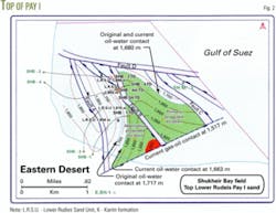
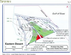
Two depth structure maps (Figs. 2 and 3) constructed on the top of Pay I and Pay II sands illustrated the structural configuration of the field at these reservoir levels. The maps, mainly based on well information and dipmeter logs, were broadly guided by the last 1997 seismic interpretation as well as by older available maps deemed reliable.
The review included openhole log, PVT, pressure, and production data.
The study identified the pay zones and determined the petrophysical properties of Pay I and Pay II (porosity (φ) = 23% and initial water saturation (Swi) = 21%).
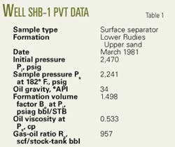
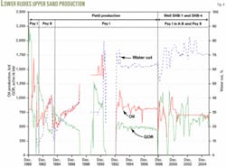
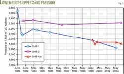
Table 1 shows the PVT data used in the material balance calculations, while Figs. 4 and 5 show the cumulative water and oil production along with the pressure at each time step in the material balance calculations.
null
null
Reserves estimate
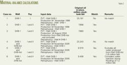
The study used a commercially available material-balance program, MBAL, for making the material-balance calculations for the Lower Rudies Upper sand.7 Table 2 summarizes the six material-balance cases selected as representative for the reservoir.
These results indicate some reservoir characteristics for the Shukheir Bay structure. The analysis notes communication between Pay I and Pay II at Well SHB-1 because of the good match obtained between Cases 2 and 3 when Pay II and Pay I were considered as a single reservoir. Case 1 did not provide a match when Pay I is separated from Pay II.
The cement bond (CBL) logs of Wells SHB-1 and SHB-4st show bad cement across and below the perforated intervals. This bad cement may cause communication behind the casing.
The material-balance calculations indicate 7.86 million bbl of oil were originally in place in both Cases 2 and 3. The calculations show no change in the original oil in place when Pay I and Pay II in Block A-B were considered as a single reservoir through Well SHB-1.
The limited original oil in place indicates that Fault B is a sealing fault, a condition confirmed by the two different oil-water contacts in the two Blocks A-B and B-C. The repeat formation test of Well SHB-1 showed the oil-water contact at a 1,717 m true-vertical depth (TVD) subsea in Block A-B, while the openhole logs of Well SHB-4st gave an oil-water contact at 1,680 m TVD subsea in Block B-C. The 37-m difference in the oil-water contact between the two blocks is almost equal to the throw of Fault B.
When Well SHB-4st was considered along with Well SHB-1 as two wells in a single reservoir (Case 4), the study revealed no match.
The study also indicated that produced water from Wells SHB-4st was too much during the limited production time. Well SHB-4st produced 1.6 million bbl of water and only 0.5 million bbl of oil during 5 years of production. The total produced water from the reservoir during 25 years of production, however, is about 5 million bbl of oil.
The CBL of Well SHB-4st showed bad cement that may cause fluid to communicate behind the casing. Cases 5 and 6 investigated this possibility.
Case 5 excluded 1.6 million bbl of the produced water from the production data. This resulted in a calculated 8.57 million bbl of original oil in place.
Case 6 assumed that 1.2 million bbl of water entered the reservoir from other formations through the bad cement in Well SHB-1. The assumption also led to a good match of the original oil in place of 9.408 million bbl.
The geological data showed that Well SHB-4st passes Pay I from the west side of Fault B and crosses Pay II in the east side of the fault.
When the study considered Well SHB-4st in the material-balance calculations along with Well SHB-1 (Cases 5 and 6), the original oil in place was greater than for Cases 2 and 3. That confirmed the geological conclusions that the increase in the original oil in place mostly is related to the effect of Pay II in Block B-C.
Volumetric calculations
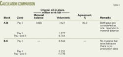
Table 3 shows that volumetrically calculated original oil in place for Pays I and II in Blocks A-B and B-C compare well with the material balance calculations with a 90.3% agreement.
The volumetric calculations possibly had inaccuracies in the rock volume used while the material-balance calculation may have had inaccuracies in the pressures used.
Recovery factor estimate
The material balance and PVT analysis showed that three different drive mechanisms produce oil:
- Gas liberation from solution at and below the bubblepoint pressure.
- Secondary gas cap.
- Water aquifer.
The mechanisms strongly influence the recovery factor that can have a wide variance across the field. The Shukheir Bay field study (Table 4) used an ultimate recovery factor of 65%, mainly estimated for Block A-B based on the methodology presented in a prior technical report.6 The recovery factor to date is 47% and well SHB-1 still produces at 700 bo/d and 70% water cut.
This estimated 65% recovery factor looks acceptable in view of the combined water influx and secondary gas-cap drive mechanisms.
The study estimated a 55% ultimate recovery factor for Block B-C because the drive mechanisms have not been ascertained, and the block may not perform the same as Bock A-B.
Redevelopment recommendations
The geological review for the Lower Rudeis Pay I and Pay II sand reservoirs together with the reservoir engineering data suggest that the horst Fault Block B-C has a good potential for additional hydrocarbons. About 89 % of the remaining reserves are concentrated in Block B-C, so that these reserves should be the primary target.
Well SHB-4st openhole logs revealed 4 m of hydrocarbon bearing sand in Pay II in the virgin Block B-C. This may confirm that Pay I in the same block should be oil-bearing. The study proposes a new well (SHB-5) in this block as a primary target.
About 0.768 million bbl of oil remain to be produced from Block A-B (Table 4) that could be produced through Well SHB-1. Accelerating the production of these reserves by drilling a new development well SHB-5st structurally higher than Well SHB-1 could be a secondary target.
Acknowledgments
The author thanks Offshore Shukheir Oil Co. (OSOCO) for giving permission to publish this article.
References
- Babadagli, T., “Mature Field Development-A Review,” Paper No. SPE 93884, SPE European/EAGE Annual Conference, Madrid, June, 13-16, 2005.
- Raza, S.H., “Data Acquisition and Analysis for Efficient Reservoir Management,” JPT, April 1992.
- Wiggins, M.L., and Startzman, R.A., “An Approach to Reservoir Management,” Paper No. SPE 20747, 65th SPE ATCE, New Orleans, Sept. 23-26, 1990.
- Satter, Abdus, et al., “Integrated Reservoir Management” Paper No. SPE 22350, SPE International Meeting on Petroleum Engineering, Beijing, Mar. 24-27, 1992.
- Dake, L.P., Fundamentals of Reservoir Engineering, Amsterdam: Elsevier, 1979.
- Abu El Ela, M., et al., Shukheir Bay Field Reservoir Study, Technical Report, March 2006.
- MBAL Manual, Reservoir Engineering Toolkit, User Guide, V. 6, December 2000.
The author
Mahmoud Abu El Ela is an assistant professor in the petroleum engineering department, Cairo University, and also works as a petroleum reservoir consulting engineer. He has a BS and MS in petroleum engineering from Cairo University and a PhD from Curtin University of Technology, Australia. He is a member in the Egyptian Engineers Syndicate and SPE.
