Argentina Salta blocks attractive despite earlier lack of success
The provinces in Argentina now have the right to offer areas for exploration. Since the National Secretary of Energy was unable to attract investments, the provinces have the opportunity to change that situation.
Neuquen, the first province to offer acreage, was followed among others by San Juan and La Pampa provinces that recently awarded areas.1 At present, Salta is offering seven areas, and Mendoza, Rio Negro, and Santa Cruz provinces are preparing acreage for several license rounds.
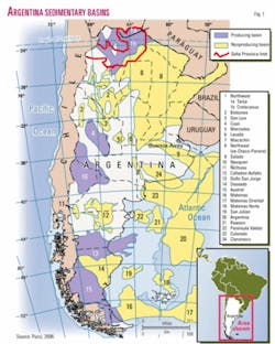
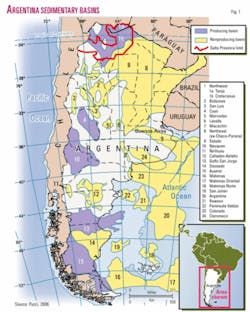
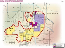
In Salta province, the first licensing round for exploration includes the Chirete, Hickmann, Malvalay, Morillo, Tartagal Oriental, and Union areas (Figs. 1 and 2), most of which fall in the Cretaceous basin.
The areas were first explored by former state oil company YPF and later operated by private companies under the terms of the Houston Plan. The areas were relinquished between 1994 and 1995. After 2004, the National Secretary of Energy transferred the areas to Salta Province.
The bid system is similar to the Argentina Exploration Plan implemented by the National Secretary of Energy under the National Hydrocarbon Law 17319.2 3 Deadline for bids is Aug. 14, 2006.
The working units vary between 300 and 150, which are equivalent to $1.5 million and $750,000. All the areas have a first exploration period of 4 years. Results of exploration have been disappointing but are inconclusive, and there is still keen interest in at least some of the Salta blocks.
Introduction
The Agua Blanca-1 well was the first commercial oil discovery in Salta and in the Northwest basin in 1926.
The well yielded oil from Carboniferous reservoirs. In the 1950s more oil was discovered in Carboniferous reservoirs in Madrejones and Campo Duran fields.
In the late 1960s, the discovery of Cretaceous oil in the Caimancito anticline (Jujuy Province) concentrated exploration in the Cretaceous basin, and several fields were discovered in Salta Province. In the 1970s production began in sub-Andean Devonian reservoirs and also in the Cretaceous basin.
In the early 1980s exploration in the Cretaceous basin extended to the east, and oil was discovered in volcanic reservoirs of Cretaceous age in adjacent Formosa province (Palmar Largo field).
During 2005, production in Salta Province was 742,535 cu m of oil and 7,071,011,000 cu m of gas.
At yearend 2004, reserves for the Northwest basin were 10.8 million cu m of oil and 95.9 billion cu m of gas. Salta Province had 9.8 million cu m of oil and condensate and 95.8 billion cu m of gas. In 2005 only one outpost well was drilled that yielded gas.
Northwest basin
In the Northwest basin, more than 10,000 m of sediments were deposited from the Precambrian to the Quaternary.
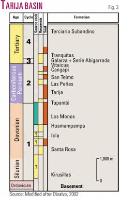
From a petroleum point of view these rocks can be grouped into five cycles separated by regional unconformities (Fig. 3).
The first cycle corresponds to the lower Paleozoic-Precambrian, which is the present economic basement. The second and third cycles correspond to the Silurian-Devonian and the Carboniferous-Permian, respectively. These two cycles contain the reservoirs and the source rocks of the Paleozoic basins.
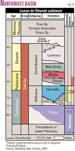
To the fourth cycle belong rocks deposited during the Cretaceous and lower Tertiary, which contain the reservoirs of the only producing basin of that age (Fig. 4). The fifth cycle comprises Miocene to Quaternary rocks. In this cycle some discoveries were made.
To the west, all these sediments are exposed and have been strongly folded and faulted, while to the east the folding and fracturing intensity diminishes.
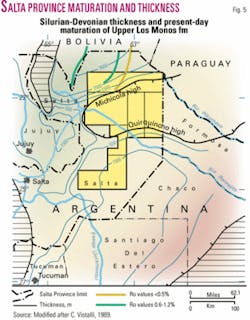
The Silurian-Devonian are more than 3,000 m thick (Fig. 5) and comprise an alternation of shaly and sandy intervals that correspond to the Silurian Kirusillas shales, the Devonian sandstones of the Santa Rosa and Huamampampa formations, and the Devonian shales of the Icla and Los Monos formations.
The main reservoir is the Huamam- pampa formation although the Santa Rosa sandstones have similar characteristics and contain significant accumulations of hydrocarbons in the sub-Andean belt. However, the Vespucio well in the western part of the Tartagal Oriental block found gas in the Huamampampa formation.4
The Los Monos formation is the source rock for the Paleozoic reservoirs in the areas offered. It is postulated that the Icla and Kirusillas formations could generate gas.
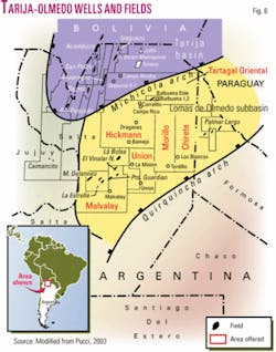
The Carboniferous cycle or Tarija basin (Fig. 6) has a similar distribution to the earlier Silurian-Devonian cycle.
The main reservoir in the Tarija basin is the Carboniferous Tupambi formation, although after the 1996 Ñacatimbay oil and gas discovery the Carboniferous Las Peñas formation has also become important as an oil and gas producer with better porosities.
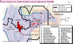
The main Cretaceous-Tertiary reservoir is the Yacoraite formation (Fig. 7), which is also the source. In the areas offered, no volcanic reservoirs of the Palmar Largo formation were reported.
The oil accumulated in Tertiary sediments found in the Campo Alcoba well has been correlated with the oils generated by the Yacoraite formation, thus indicating long migration paths.
The main source rocks for the Carboniferous and Devonian reservoirs are shales of the Los Monos formation. It has a lower section which has generated the gas and condensate accumulated in the Devonian reservoirs, while the upper section has generated the hydrocarbons accumulated in Carboniferous reservoirs (Fig. 5). The Devonian Icla formation and the Silurian Kirusillas formation are potential source rocks.
Areas offered
The areas presently offered by the Salta Province government are Tartagal Oriental, Hickmann, Morillo, Chirete, Union, and Malvalay (Fig. 2).
Tartagal Oriental covers 2,655 sq km that was part of the Palmar Largo Association Area. The area was awarded to a group of companies with Pluspetrol as operator. The area was relinquished, and Pluspetrol kept the production lots located in Salta and the adjacent Formosa Province.
The main targets in the western part of the block is the oil prone productive Carboniferous Tupambi and the deeper gas prone Devonian Huamampampa and Santa Rosa plays.
In the Tartagal Oriental area, the petroleum systems are the Los Monos-Tupambi and the Yacoraite-Yacoraite.
Gas production from the Huamam- pampa formation was obtained in the Vespucio x-1 well, abandoned for technical reasons at 5,000 m.4 The Campo Alcoba 1001 well recovered 12 cu m/day of 38° gravity oil from the Tertiary Serie Abigarrada formation at about 2,700 m.
However, the studies of gas chromatography, biomarker analysis, and the isotopic composition of the oil found in the Tertiary reservoir correlate well with the typical Cretaceous oil like Balbuena Este field. These studies indicate a lacustrine source rock like the Yacoraite formation.
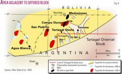
Some of the Paleozoic traps found in and outside the area are paleovalleys carved in Devonian sediments and filled by sandstones of the Tupambi formation, similar to Tonono field located to the northeast outside of the area, and also in Bolivia and Paraguay (Fig. 8).
Other prospects are closures against pre-Cretaceous folds. The identification of these traps would require modern seismic data and detailed mapping of the individual sand lenses.
The Devonian Huamampampa formation might be prospective along fault zones where secondary porosity can develop. However, when the formation is away from the fold belt it becomes a high-risk objective.
The eastern part of the basin has the Yacoraite formation as the only proven reservoir. Some plays are homoclines or anticlines in the downthrown blocks of faults located between the master fault and the depositional border (Michicola high). Balbuena Este field consists of two anticlines developed along the downthrown block of the fault, in an E-W direction, where the Yacoraite formation reservoirs produce oil (Fig. 9).
It is likely that stratigraphic-structural plays in the Yacoraite formation occur as combination traps and involve the development of oolitic grainstones and ostracods, etc., although depths to objectives are more than 4,500 m.
The Tartagal Oriental area has all the ingredients to find hydrocarbons, but further detailed and modern studies are necessary.
YPF explored the 6,555 sq km Hickmann area, it was awarded to Bridas-Texaco in 1987 with Texaco as operator and then relinquished to the Secretary of Energy in 1995.
The area covers the north flank of the basin and the deeper part of the Lomas de Olmedo subbasin (Fig. 6).
The wells drilled in the area found the zones of interest, but only Balbuena x-1 had gas shows in the Lecho, Yacoraite, Olmedo, and Mealla formations while the Campo Rico x-1 well drilled by Bridas found oil shows only in the Yacoraite formation.
The Dragones well drilled by Texaco found two salt layers and encountered only the Mealla formation with reservoir characteristics. Texaco’s Corralito well yielded oil in basal sandstones of the Mealla formation. The Olmedo formation had total organic carbon values of 3% and Type II organic matter. However, maturation studies showed that the sediments were outside the oil window.
In the north flank are likely to be found structures similar to those described for the Tartagal Oriental Cretaceous plays. In the deeper parts of the basin drillers are likely to find anticlines with four-way closures associated with inversion tectonics at 4,000-5,000 m in Yacoraite reservoirs. Light oil and gas are expected. Complex drilling is expected due to evaporites and overpressured zones with water.5
The Morillo area covers 3,518 sq km, and the Salta government established at least 300 working units. The area, first held by YPF, was granted to Pluspetrol in 1987 under the Houston Plan. After relinquishment, the Secretary of Energy awarded the area to Dong Won in 1994. Whether Dong Won conducted exploration is not known.
YPF drilled the Tordillo well on a four-way closed structure but did not find the Yacoraite formation. It completed the well in Devonian sediments. It is possible that the Yacoraite occurs to the north and center of the area.
The area is located between the Michicola high to the north and the Quirquincho high to the south (Fig. 6).
Occurrences of source rock and traps are unknown.
The Chirete acreage covers 3,551 sq km. Minimum requirements are 300 working units. YPF awarded Chirete in 1987 to Pluspetrol, which relinquished it in 1994.
YPF and Pluspetrol explored the Chirete area. The former drilled three wells, while the latter drilled two. YPF’s wells did not reach the Yacoraite. Pluspetrol’s second well tested the upper part of the Yacoraite formation but could not find reservoir facies.
The Los Blancos well, which tested the south flank, was abandoned at 3,088 m in the Devonian Los Monos formation.
The Union area has a surface of 2,467 sq km. At least 150 working units are required.
The first exploration work was carried out by YPF, which acquired seismic and drilled the Union well.
The block was awarded under Houston Plan terms in 1987 to Astra, which after recording seismic data and drilling the La Mision well relinquished the area.
In 1994, Dong Won obtained license rights and returned the area in 1997. It is unknown whether the company explored the area.
The Union well found the Yacoraite formation and was abandoned in Devonian sediments.
The Astra La Mision well also penetrated the Yacoraite formation and was abandoned. It is unknown whether the area has sufficiently mature source rocks or undrilled structures.
The Malvalay area covers 6,600 sq km. The government requires a minimum of 300 working units.
After YPF first explored Malvalay, it was awarded in 1994 to Dong Won under the terms of the Argentina Plan. The area was relinquished in 1997 and transferred to Salta Province.
YPF (Repsol) recorded seismic and drilled the Malvalay well, which found the Santa Barbara Subgroup resting on Devonian sediments. No Cretaceous source rock is present. However, the Devonian has 200 m of the shaly Rincon formation, but it is unknown if it is sufficiently mature. The TD was 3,500 m belowground.
References
- Pucci, Juan C., “Neuquén Province offers areas with exploration potential,” OGJ, Sept. 24, 2001, pp. 50-54.
- Pucci, Juan C., “Potential assessed in Argentina’s association contract areas,” OGJ, June 20, 1994, pp. 55-58.
- Pucci, Juan C., “Relinquishments in Argentina will boost exploration interest,” OGJ, Sept. 30, 1996, pp. 103-107.
- Pucci, Juan C., “Northwest basin,” in: “Atlas of the Argentina’s Oil and Gas Fields,” unpublished report, 2003.
- Gomez Omil, R., and Boll, A., “Cuenca Cretacica del Noroeste Argentino,” in Chebli, G., Cortinas, J., Spaletti, L., Legarreta, L., and Vallejo, E., eds., “Frontera Exploratoria Argentina,” VI Congreso de Exploración y Desarrollo de Hidrocarburos, 2005, pp. 63-76.
Bibliography
Disalvo, A., “Cuenca del Noroeste: Marco geológico de la actividad petrolera,” in Schiuma, M., Hinterwimmer, G., and Vergani, G., eds., “Simposio Rocas reservorios de las cuencas productivas de la Argentina,” V Congreso de Exploración y Desarrollo de Hidrocarburos, 2002, pp. 663-677.
Disalvo, A., Rodríguez Schelotto, M., Gomez Omil, R., Hoffman, C., Benitez, J., and Hurtado, S., “Los reservorios de la formación Yacoraite,” in Schiuma, M., Hinterwimmer, G., and Vergani, G., eds., “Simposio Rocas reservorios de las cuencas productivas de la Argentina,” V Congreso de Exploración y Desarrollo de Hidrocarburos, 2002, pp. 717-738.
Stark, D., Rodriguez, A., and Constantini, L., “Los reservorios de las Formaciones Tupambi, Tarija, Las Peñas y San Telmo,” in Sciuma, M., Vergani, M., and Hinterwimmer, G., eds., “Las Rocas Reservorios de las Cuencas Productivas de la Argentina,” V Congreso de Exploración y Desarrollo de Hidrocarburos,” 2002, pp. 699-716.
Vistalli, Maria C., “La cuenca Siluro Devónica del Noroeste,” in Chebli, G., and Spaletti, L., eds., “Cuencas Sedimentarias Argentinas,” Serie Correlacion Geologica 6, Universidad Nacional de Tucuman, 1989, pp. 19-41.
The author
Juan Carlos Pucci (jcp@ darcom.com.ar) has been active in international exploration for many years. His employers included GSI, Cities Service, and Mobil. He was the geologist representing the Secretary of Energy in privatizing Argentina’s upstream sector. At present, he is a consulting geologist specializing in South America and in organization of the upstream privatization process. He is also working on the definition of new major plays in South American basins. He has an MS in petroleum geology and a PhD in geology from the University of Buenos Aires.
