ARGENTINA OFFSHORE-2: Southern offshore basins of Argentina underexplored
This is the second of two parts on the status of Argentina’s underexplored basins in the South Atlantic Ocean, only one of which has commercial hydrocarbon production.
Offshore Austral basin
Austral is at present Argentina’s only productive offshore basin.
The offshore part of the Austral basin has an extent of 46,000 sq km (Fig. 2). Through 2005, 108 wildcat wells were drilled and 34,840 km of 2D seismic and 3,530 sq km of 3D seismic were acquired.
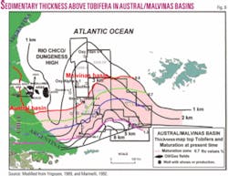
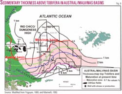
Hidra oil and gas field was discovered in 1982 and placed on production in 1989 (Fig. 8).
On June 2005, Total Austral SA and partners began production from the Carina-Aries gas fields on Block CMA-1 off Tierra del Fuego (Fig. 8).
The evolution of the Austral/Malvinas basin has three main tectonic phases, rift (Jurassic-Early Cretaceous), sag (Early Cretaceous), and foreland (Early Cretaceous to Cenozoic). By middle Eocene-Oligocene in the southern part of the Malvinas basin began the foredeep phase and the formation of compressional structures in the foreland.
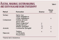
Seismic data showed that the Austral, Malvinas and East Malvinas, and South Falkland basins are interconnected and although their histories vary; regional correlation of the major sequences has been postulated (Table 6).
All the production is obtained from the Cretaceous Springhill formation. The Springhill formation represents a depositional megasequence that overlaps the western flank of the Rio Chico high.
The Springhill formation has been divided into several depositional sequences developed over the Basement or/and the volcanic Tobifera series. The main sequences are the Hidra, productive from fluvial channels and bars in Hidra and Argo fields, the Argo-Paloma sequence represented by estuarine channels and bars, and by the Carina sequence which consists of marine sand lobes and transgressive estuarine channels and bars both productive in the Carina field.7
Three petroleum systems have been described for the Austral basin. The Pampa Rincon (Lower Inoceramus)-Springhill, is the principal of the basin and contributed most of the production. The Pampa Rincon (Lower Inoceramus)-Magallanes is responsible for Tertiary production in the Santa Cruz province.
The Tobifera-Tobifera/Springhill reported on Tierra del Fuego island consists of claystone intercalations in the lower part of the Tobifera series that may have charged reservoirs of the Tobifera series and reservoirs of the Springhill formation.
The Pampa Rincon (Inoceramus)-Springhill and the Tobifera-Tobifera/Springhill petroleum systems both exist in the offshore Tierra del Fuego. The other probably occurs along the offshore Austral basin.
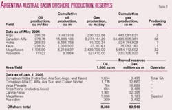
The reserves of the offshore Austral basin at the end of 2004 were 8,366,000 cu m of oil and condensate and 83,540 trillion cu m of gas.
Possibilities may exist in the fold belt located in the southern part of the offshore Austral, Malvinas, East Malvinas, and South Malvinas basin complex.
The reservoirs are of Tertiary age and should correspond to turbiditic systems. The structural traps are located along a front of transpressional faulting associated to the interaction of the South America and Scotia plates.5 The play is also of high risk with low prospectivity.
Malvinas basin
The Malvinas basin, covering 141,116 sq km, is located east of the Rio Chico or Dungeness high between the Falkland Islands and the mainland.
Approximately at the latitude of Rio Grande, the Dungeness high terminates, and since Upper Cretaceous times has allowed open communication between the Malvinas and Austral basins.
Eighteen exploration wells have been drilled on the western flank of the basin with the Lower Cretaceous Springhill sandstone as the main objective. Seismic acquired totals 37,707 km of 2D and 2,240 sq km of 3D.
Two of the wells drilled by Exxon in 1981 were new field discoveries that produced oil and gas at rates of 397 cu m/day of oil and 567,000 cu m/day of gas, but reserves were considered noncommercial.
The remaining wells were dry, and not all the wells drilled appear to have been located on closed structures. In addition, the reservoir quality has been in some cases a factor in the lack of exploration success.
The present day maturation levels of organic matter suggest that petroleum generation occurs at 1,500-3,800 m. The source rock Inoceramus formation is the same as that in the Austral basin. The unit presents fair to good generating potential with TOC values of 1 to 3%, Ro values of 0.5 to 1.0%, and hydrogen index near 400 (Fig. 8).
The best undrilled structures are located in the southern part of the basin.
Exploration results, although not encouraging, were not conclusive. Therefore, the basin has merit for an exploration effort.
Eastern Malvinas basin
The Eastern Malvinas basin is east and southeast of the Falkland Islands in 200 to 2,500 m of water.
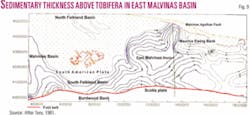
East Malvinas was first identified by seismic in 1977, and Turu8 made a thickness map at the top of basement (Fig. 9).
The basin is bounded to the east by the Maurice Ewing Bank and to the south by the Burdwood Bank. To the west it laterally passes into the South Falkland basin, and to the north the basin is truncated by the Malvinas-Agulhas transform fault zone. The available data indicate that the stratigraphy and the petroleum systems are similar to the Austral and Malvinas basins.
In addition and on the basis of the YPF’s Ciclon es-1 well results, Marinelli et al.9 postulated that oil probably migrated from Cretaceous source rock to Tertiary reservoirs as occurs on land in the Austral basin’s “Intermediate Zone.”10 The stratigraphy is similar to that of the Austral and Malvinas basins (Fig. 8).
With a few wells drilled in the easternmost part of the basin, prerift, synrift, and postrift/drift stages were established.
Deepsea Drilling Project wells tested Oxfordian claystones that contain Type II kerogens. Modeling studies suggested that the source rocks are possibly mature for oil generation at about 3,000 m below the seabed.
The No. 330 well penetrated Oxfordian sandstones of possible reservoir quality that overlie a swampy terrestrial environment.
On the basis of the existing seismic data and by correlation with analogous basins, numerous play types can be predicted.
South Falkland basin
This basin lies beneath 500 m to 2,500 m of water south of the Falkland Islands and is mainly a Tertiary foreland basin that was developed along the southern margin and overlying the East Malvinas basin.11
The overthrust sequence of Cenozoic rocks along the boundary between the Scotian and South American plates is also its southern limit.
The basin was not drilled and is known only from several DSDP wells located to the east. The information revealed that the stratigraphy (Table 6) and probably the source, reservoir, and seal rocks occurring in the Malvinas basin are present in the South Falkland basin. The thickness over the basement is about 4 km (Fig. 9).
The hydrocarbons sourced in the East Malvinas basin possibly charged the South Falkland basin.
Fish11 reported structural and stratigraphic traps and Tertiary reservoirs of deep marine clastics.
North Falkland basin
The North Falkland basin is 500 km north of the islands in 150-2,000 m of water (Fig. 2). The basin covers 56,084 sq km.
During 1998, six wells were drilled in the North Falkland basin. Drilling took place in 250-460 m of water. Before drilling, the companies acquired 6,910 km of 2D seismic and 350 sq km of 3D seismic.
The North Falkland basin is a Jurassic-Cretaceous failed-rift basin. This is a separate basin with a petroleum system unrelated to that developed in the other basins.
Eight tectono-stratigraphic units were recognized: a pre-rift sequence; fluvio-lacustrine, early synrift interval; a late synrift fluvio-lacustrine interval, a rift-sag transitional unit; an early postrift lacustrine interval; a middle postrift transgressive interval; a late postrift terrestrial to marine unit of Albian to early Paleocene age; and a post-uplift sag thermal subsidence unit of Paleocene to Recent age.12
Five of the wells recorded oil shows, and up to 32% gas was also recorded in cuttings. Source rocks, reservoirs, seals, and traps of good quality have all been identified in the North Falkland basin.
Although additional seismic may confirm this assumption, the basin may extend farther west into the San Julian basin, north into the main South Atlantic basin system, and also to the east.13
Possibly the best analog to the North Falklands basin is the San Julian basin, since both share silicic-volcaniclastic basin fills within a continental depositional environment.
The synrift and early postrift intervals contain about 1,000 m of lacustrine claystones with TOC values up to 7.5%. It is an algal, oil-prone source of excellent quality, Type I/II kerogen, and could have generated over 60 billion bbl of oil. Probably Jurassic source rocks are gas mature in the deepest part of the basin and may be oil-prone elsewhere.
Some sandstones layers about 100 m thick have been encountered above the main source rock interval with porosities ranging up to about 30%.
The basin is still at the very earliest stage of exploration. However, there are more untested plays than those partially tested.
Argentina basin
During the last decade offshore exploration was focused in two regions: the continental slope and the marine fold belt which is located at the south portion of the Malvinas basin and the southern extension of the offshore Austral basin (Fig. 2).
Exploration consisted of reflection seismic and sea bottom samples but no drilling. Figueroa et al.5 contains an account of the exploration work.
The continental slope is developed in 200-4,000 m of water. Structural and stratigraphic type plays were identified.5
The structural play is located in the easternmost Colorado basin in 1,500 m of water, while the stratigraphic play is the southern Argentine basin.
The structural play is associated with structural traps over basement highs. This high separates the Colorado basin from the Argentina basin. The modeling of the stratigraphy and of the petroleum systems assumed Jurassic and Cretaceous marine and lacustrine source rocks, reservoir marine sandstones of Cretaceous age deposited in platform environment, and seals corresponding to Cretaceous and Tertiary platform and deepsea shales.
Figueroa et al.5 indicates that this play is different from those found in the Colorado basin and has good exploration potential.
The stratigraphic play is in 500-2,500 m or more of water.
Since this part of the basin was never drilled, the occurrence of a petroleum system is hypothetical. The stratigraphy and exploration potential are speculative and based on analogies with known basins.
The possible source rocks are Aptian shales, while the reservoirs should be turbiditic sandstones of Cretaceous or Tertiary age and sandstones filling old valleys.
Acknowledgments
I appreciate the library’s staff of the Argentina Oil and Gas Institute (IAPG), Ms. Eugenia Stratta, Silvia Dominguez, and Veronica Canepa, for help preparing the manuscript. ✦
References
1. Turic, Mateo, “Actividades exploratorias en el margen continental Argentino: perspectivas,” Petrotecnia, No. 3, 2002, pp. 24-29.
2. Figueroa, Daniel, “Desafíos de la Exploración Offshore en Argentina,” II Congreso de Hidrocarburos 2003, IAPG, Buenos Aires.
3. De Santa Ana, H., Ucha, N., and Veroslavsky, G., “Geología y Potencial Hidrocarburífero de las Cuencas Offshore de Uruguay,” INGEPET, (EXPR-3-HD-43), Lima, 2005.
4. Mancilla, Oscar, Salinas, Alicia, and Soubies, E.D., “Exploración en aguas profundas en la Cuenca del Colorado, República Argentina. Utilización del modelado estratigráfico numérico,” Congreso de Exploración y Desarrollo de Hidrocarburos 2, Mar del Plata, 2002.
5. Figueroa, Daniel, Marshall, P., and Prayitno, W., “Cuencas atlánticas de aguas profundas: principales plays,” in Chebli, G.A., Cortiñas, J.S., Spalletti, L.A., Legarreta, L., and Vallejos, E.L., eds., “Frontera Exploratoria,” VI Congreso De Exploración y Desarrollo de Hidrocarburos, IAPG, Buenos Aires, 2005, pp. 325-335.
6. Homovc, Juan F., and Luis Constantini, “Hydrocarbon Exploration Potential within Intraplate Shear Related Depocenters: Deseado and San Julian Basins, Southern Argentina,” AAPG Bull., Vol. 85, No. 10, 2001, pp. 1,795-1,816.
7. Arbe, H., and F. Fernandez Bell Fano, “Los reservorios de la formación Springhill en el área costa afuera,” in Schiuma, M., Hinterwimmer, G., and Vergani, G., eds., “Rocas Reservorio de las Cuencas Productivas de la Argentina,” IAPG, 2002, pp. 75-89.
8. Turu, J.T.,”Informe Geofísico Cuenca Malvinas Oriental,” YPF unpublished report, 1981.
9. Marinelli, R., Franzin, H., and Laffitte, G., “La Exploración Costa Afuera en la Cuenca de Malvinas,” Boletín de Informaciones Petroleras (BIP), No. 32, 1992, pp. 67-78.
10. Pucci, J.C., “Relinquishments in Argentina will boost exploration interest,” OGJ, Sept. 30, 1996, pp. 103-107
11. Fish, P., “Frontier South, East Falkland basins reveal important exploration potential,” OGJ, Dec. 5, 2005, pp. 34-40.
12. Richards, P.C., and Hillier, B.V., “Post-Drilling Analysis of the North Falkland Basin,” Journal of Petroleum Geology, Vol. 23, No. 3, 2000, Part I, pp. 253-272, and Part II, pp. 273-292.
13. Bransden, P.J.E., Burges, P., Durham, M.J., and Hall, J.G., “Evidence for multiphase rifting in the North Falkland Basin,” in Cameron, N.R., Bate, R.H., and Clure, V.S., eds., “The oil and gas habitats of the South Atlantic,” Spec. Pub. Geol. Soc., London, Vol. 153, 1999, pp. 425-442.
Bibliography
The book, “Geologia y Recursos Naturales de la Plataforma Continental Argentina,” (in Spanish), XIII Congreso Geologico Argentino and III Congreso de Exploración de Hidrocarburo, Relatorio, published in 1996 jointly by the IAPG and the Argentine Geological Association (AGA), contains detailed papers on Argentina’s offshore geology and is referenced extensively here and recommended for interested readers.
Quantitative production and reserves data are derived from Secretary of Energy and the IAPG (Argentine Oil and Gas Institute).
Baldi, Jorge E., Wartenburg, G., Bettini, F., Kovas, E., Marinelli, R., Franzin, H., and Bushnell, D., “Potencial petrolero de la Cuenca del Salado Offshore,” Boletín de Informaciones Petroleras (BIP), No. 54, 1998, pp. 38-57.
Figueiredo, A. Pellon de Miranda, Ferreira, R.F., and Zalan, P., “Cuenca de San Julian,” in Ramos, V., and Turic, M., eds., “Geología y Recursos Naturales de la Plataforma Argentina,” Asociación Geologica Argentina and Instituto Argentino de Petroleo y Gas, Buenos Aires, 1996.
Galeazzi, Jose S., “Structural and Stratigraphic Evolution of the Western Malvinas Basin, Argentina,” AAPG Bull., Vol. 82, 1998, pp. 506-524.
Lesta, P., “La exploración de la plataforma continental Argentina: pasado, presente y futuro,” Petrotecnia, No. 3, Buenos Aires, 2002, pp. 16-23.
Stoakes, F.A., Campbell, C.V., Cas, R., and Ucha, N., “Seismic stratigraphic analysis of the Punta del Este basin, offshore Uruguay, South America,” AAPG Bull., Vol. 75, 1991, pp. 219-240.
Tavella, G., “Cuenca del Salado,” XVI Congreso Geológico Argentino, Actas, La Plata, 2005.
Yrigoyen, M., “Cuenca de Malvinas,” in Chebli, G., and Spalletti, L., eds., “Cuencas Sedimentarias Argentina,” Serie Correlacion Geologica 6, Universidad Nacional de Tucumán, 1989, pp. 481-491.
