Annapolis discovery points up potential of deepwater Scotian slope off E. Canada
CANADA'S OFFSHORE—3
Deepwater geologic provinces remain a principal frontier for hydrocarbon exploration worldwide. A significant number of such provinces are associated with passive continental margins of the greater Atlantic basins,1 including the northern Gulf of Mexico, offshore Brazil, West Africa, Morocco, and Eastern Canada. Among these regions, the Scotian slope of Eastern Canada is considered especially significant to North American exploration as it represents one of the last "megaplay" areas yet to be drilled and developed.
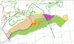
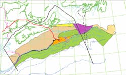
Located east of Nova Scotia in 300 m to over 4,000 m of water, the Scotian slope extends for some 850 km in a northwest-southeast direction from the Canada-US border to the Newfoundland margin (Fig. 1).
Geologically, the slope area comprises the downdip portion of a regional depocenter known as the Scotian basin, which contains up to 20 km of deposits, mainly of Jurassic-Cretaceous age.
The updip portion of this basin is represented by the broad, flat Scotian shelf, a major new gas-condensate producing area of North America (estimated reserves >16 tcf and 350 million bbl of condensate). Estimates of Scotian shelf gas reserves have varied from a minimum of 16.3 tcf to a maximum of 50 tcf. Kidston2 provided a recent review of historical estimates through 2002.
Shelf production is associated with thick, Upper Jurassic-Lower Cretaceous deltaic deposits involved in growth-type faulting and rollover structures. Prodelta equivalents, including sand- and mud-rich turbidite sequences, are identified as the dominant reservoir type along the slope. As in other deepwater provinces, Scotian slope deposits are known from seismic data to be affected by complex salt-related deformation.
An important assessment of hydrocarbon potential along the Scotian slope has been recently completed.2 This assessment, which effectively doubles earlier government estimates of recoverable volumes, benefited from three main sources of geoscientific information:
1. Well data from the downdip Scotian shelf and from a limited number of wells drilled along the slope proper.
2. Abundant new seismic information, including 30,000 line-km of 80-fold 2D data recorded in 1998-2000 by TGS-Nopec.
3. Selective analysis of three analog basins, the northern Gulf of Mexico, offshore Brazil, and offshore west-central Africa.
The information presented in the new assessment, combined with that from other published reports on the Scotian continental margin, provides an up-to-date scientific framework for evaluating petroleum resources of the slope province. The following sections of this article summarize this framework and discuss the new assessment results.
Regional setting
Processes typical of Atlantic-type passive margins formed the continental boundary of Nova Scotia.
Following initial uplift, continental rifting, and pull-apart tectonics in the Late Triassic-Early Jurassic, thermal cooling and long-term regional subsidence extended from Jurassic to Tertiary time.
Depositional history involved a progression from early synrift (terrestrial) material and evaporite accumulation to a prograding shelf-carbonate bank system, and then buildup of considerable thicknesses of clastic sediments derived from major delta systems and, later on, from coastal plain settings.
These deposits have been profoundly affected by various types of faulting and, more significantly, by long-term movement of mobile salt, which has generated many of the diapiric, allochthonous, and minibasinal features observed, for example, in the Gulf of Mexico.3
The greater Scotian margin (shelf and slope) is composed of a number of separate tectonic elements (Fig. 1). Three of these elements, the LeHave platform, Sable subbasin, and Abenaki subbasin, are where a majority of offshore drilling has taken place. The Scotian slope exists downdip from a distinct shelf break and is generally narrower than the total shelf. Present-day submarine canyons are a marked feature of the slope from about 61° W. Long. to the northwest.
Hydrocarbon discovery on the Scotian shelf began mainly in the 1980s. Most fields have been located in the Sable subbasin, in the vicinity of Sable Island. However, the recent discovery of gas at greater depths and deeper stratigraphic horizons in the Abenaki subbasin (Deep Panuke discovery by EnCana in 2000) is considered to have opened up new and possibly more widespread potential for the shelf.
As of 2001, Scotian shelf production has benefited considerably from increasing infrastructure, including the completion of regional gas transportation, the Maritimes & Northeast Pipeline, serving the heavily populated areas of eastern Canada and the northeastern US (Fig. 1).
Stratigraphy
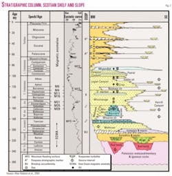
As can be seen from a simplified stratigraphic column for the Scotian basin (shelf and slope), the estimated thickness of the total section is on the order of 22 km (Fig. 2).
Roughly 35-40% of this total is composed of Late Jurassic-Mid Cretaceous (Oxfordian to Albian) deposits, which are considered to hold the majority of hydrocarbon potential on the slope.
Lowermost deposits include Late Triassic-Early Jurassic synrift red beds, evaporites, and related sediments below a regional unconformity (BU) interpreted to mark final continental breakup. This part of the total section includes the Argo salt, which is widespread and mobilized along the lower shelf and slope. Potential source rocks exist in lacustrine shales of this interval.
Post-rift deposits, of Early-Late Jurassic age, include shallow marine clastics that accumulated updip from a major carbonate platform/ramp system, represented by the Abenaki formation. The outer, reef-bearing margin of the Abenaki platform marked the shelf edge. Reservoir rocks exist in various facies (e.g., shoal, reef, talus) of the Abenaki, while offshore slope shales comprise potential source beds.
Overlying deposits consist of thick clastic sequences associated with the long-lived, Late Jurassic-Cretaceous Sable Delta. These deposits are best developed in the Missisauga formation, a main producing horizon in Scotian shelf fields. Tapering off in sediment input and accumulation took place during deposition of the Logan Canyon and Dawson Canyon formations.
Offshore, prodelta deposits, including widespread slope turbidites and organic shales, are present in the Verrill Canyon formation. Several shale intervals, marking important episodes of marine transgression, exist in this portion of the Jurassic-Cretaceous section. Another such event at the end of the Cretaceous period led to deposition of marine marls and chalky mudstones of the Wyandot formation, an important regional marker horizon.
Tertiary deposits in the Scotian basin consist of shelf mudstones and prograding shallow marine siliciclastic sequences on the shelf and upper slope. Deepwater currents redistributed some of this material out onto the deeper water slope and adjacent abyssal plain. Sedimentation rates became elevated in the Quaternary period, with several hundred meters of marine and glacial deposits accumulating along the outer shelf and slope.
Reservoirs and source rocks
In their analysis of Scotian slope potential, Kidston et al.2 discussed the principal reservoir and source rock intervals that are interpreted to exist along the Scotian slope (Fig. 2).
Reservoirs should include mainly turbidite deposits of the Verrill Canyon formation. Such deposits have been reportedly identified in slope wells, but detailed information remains unavailable at the time of this writing.
In general, slope turbidites of the Scotian basin largely represent deltaic and outer shelf sediments transported into deeper water environments by submarine canyons and by various submarine mass wasting processes, such as earthquake or storm-induced slumping and debris flows.
A range of sand-bearing facies, including channel-fill, overbank-levee, sheet-flow (amalgamated and interbedded with nonreservoir silts and clays), and fan-lobe deposits, can be expected to comprise potential reservoirs in slope settings.
Source rock data are scarce from the few older Scotian slope wells (data from newer wells remain confidential). Studies of documented source beds on the Scotian shelf indicate a dominance of terrestrial-derived, type IIB and type III kerogen,4 suggesting the same is true for the slope and, therefore, that both shelf and slope are largely gas and gas-condensate prone.
Kidston et al.2 reported results from five simulated slope wells, constructed using patented BasinMod software to study possible source rock occurrence and character.
Four probable and two speculative source intervals were identified. Probable source rocks included:
1. Logan Canyon formation (Cretaceous; Albian-Cenomanian);
2. Verrill Canyon formation (Cretaceous portion; Berriasian-Valanginian);
3. Verrill Canyon formation (Jurassic portion; Kimmeridgian-Oxfordian); and
4. Abenaki formation (Misaine shale member; Jurassic, Callovian).
The two speculative source intervals were the Mohican formation (Jurassic, Toarcian-Bajocian) and synrift lacustrine (unnamed) facies rocks of Triassic age (Carnian-Norian).
Analysis of these intervals in the simulated wells suggested several conclusions.
First, maturation levels for gas-condensate generation appear optimal in Early-Middle Cretaceous deposits.
Second, Jurassic and older source rocks are likely to be overmature (possible dry gas generation).
Third, hydrocarbon expulsion took place in two separate episodes, in the Late Cretaceous/Early Paleocene and Oligocene/Pliocene, associated with periods of rapid subsidence and burial of older sediments.
Structural style
The cartoon cross section, derived from Kidston et al.,2 illustrates the major structural styles affecting shelf and slope deposits (Fig. 3).
In many areas, the shelf margin is marked by listric normal faulting, which may cut deposits as old as Jurassic and as young as Tertiary. In some cases, faulting may be salt-related. Growth-type faults are abundant in downdip deltaic deposits (Missisauga formation). They are less prevalent in underlying Abenaki carbonates and along the upper slope.
Slope structures, instead, are directly associated with mobilized salt and with basement faults that penetrate into the Mesozoic section. Mobilization is interpreted to have begun in the late Jurassic, as a result of rapid sediment loading, and has continued to the present day.5
As suggested by Fig. 3, there is a general downdip progression in salt-related structures. This progression can be described as follows:
1. Outer shelf-rooted pillows, walls, and stocks;
2. Upper slope: thinned and displaced salt, with local allochthonous masses at deep stratigraphic levels (Jurassic);
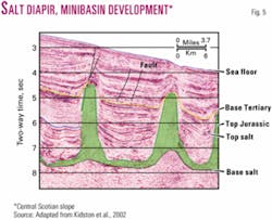
3. Middle-lower slope: allochthonous salt canopies at the Upper Jurassic-Middle Cretaceous level, which have developed into vertical diapirs penetrating as high as the Upper Tertiary, with crestal faulting and intervening salt-withdrawal minibasins; and
4. Lower slope: allochthonous salt canopies intruded into Mid-Late Cretaceous sediments, with salt overthrusting along the leading edge.
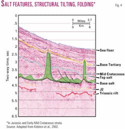
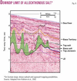
Many of these features can be seen in the seismic profiles of Figs. 4-6. Minibasins, where most deepwater discoveries to date have been made, are particularly abundant within the diapir province of the mid-lower slope (Fig. 5). The long-lived nature of some of these basins has helped give rise to significant internal (intrabasinal) deformation in many cases.
Patterns of salt withdrawal and intrusion have been variable and complex as evidenced by the diversity of observed structures, which include both normal and reverse faulting, folding, turtle features, tilting, and decollement.
Broad, relatively flat-topped salt canopies, such as those observed in the Gulf of Mexico, appear largely absent on the Scotian slope. However, the potential for subsalt entrapment of hydrocarbons is evident in many places, where salt has intruded to higher stratigraphic levels along the middle portion of the slope, i.e., where sand-bearing turbidite systems should still be present.
A known influence on structural development along the outer shelf and upper slope is an overpressure cell in Cetaceous and Upper Jurassic sediments. Top of overpressure varies from about 8,900 ft (2,710 m) subsea along the Scotian shelf to 17,000 ft (5,180 m) on the upper and middle slope.
In the productive portion of the shelf, where it has been studied, overpressure occurs in porous, gas-charged sandstones interbedded with and encased by impermeable shales or limestones. Gas generation from adjacent shales is interpreted to have contributed toward the geopressure phenomenon.
Growth faulting appears to be accentuated within the overpressure cell. The downdip limit of this cell, on the Scotian slope, is not yet known due to the lack of adequate drilling.
Play types and resource assessment
Twelve play types have been interpreted for the Scotian slope based on seismic and well data and analogy with other, producing passive margins such as the Gulf of Mexico. Play types were designated as assessment units and evaluated in terms of their total hydrocarbon potential, using estimated geological parameters (thickness, porosity, oil-gas saturation), areal extent, and volumetric considerations.
Plays can be divided into three groups, based on total estimated potential (Table 1). The first four plays in the high-potential group account for over 70% of the total estimated mean recoverable resource (in million barrels of oil equivalent) for the entire slope province.
These plays include basin flank and floor positions in salt-withdrawal minibasins and upper slope settings associated with the Abenaki carbonate margin and with structural traps defined by deep salt features and by listric, down-to-the-basin faults. Together, these four play types are assessed to contain a mean recoverable resource of 9,941 million bbl of oil equivalent.
The total hydrocarbon resource determined by Kidston et al.2 for the Scotian slope is no less than 41 tcf and 5 billion bbl of unrisked recoverable reserves. As much as 15 tcf and 2 billion bbl more were assessed as possible reserves.
These volumes effectively double earlier estimates for the slope and suggest that successful exploration and development over the next two decades, coupled with continued development on the outer Grand Banks, could shift the center of future Canadian gas supply from the western to the eastern portions of the country.
Recent drilling
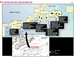
Since 2001, seven new wells have been drilled on the Scotian slope in 3,200 ft (980 m) to 6,800 ft (2,100 m) of water (Fig. 7).
One of these locations encountered significant flows of gas and may represent the first discovery on the slope.
This well, the Annapolis G-24, was drilled in 2002 by a group that included Marathon Oil, operator, 30% interest, EnCana Corp. 26%, Norsk Hydro Canada 25%, and Murphy Oil 19%. The discovery well represents a twin to the Annapolis B-24, which encountered strong flows of gas at a depth of 11,470 ft (3,497 m), necessitating well-control action and causing borehole deterioration.
Located 500 m away, the Annapolis G-24 reached total measured depth at 20,282 ft (6,182 m) and experienced gas flows from the same interval as in the B-24 well. This interval is described as containing "100 ft of net gas pay over several zones"6 and is assumed by most workers to comprise a package of Upper Cretaceous turbidite sands, possibly in a minibasin flank setting.
Marathon and partners temporarily abandoned the well in late 2002 to conduct further analysis of well information and to perform more seismic work. The group has not yet announced whether it considers the well fully commercial.
Nevertheless, the Annapolis G-24 is considered highly significant in that it confirms the existence of an active petroleum system, with accumulation in a probable salt-related setting.
Slope outlook
The deepwater Scotian slope of eastern Canada is a world class exploration opportunity in the early stages of activity. Recent assessments of the hydrocarbon potential for this province suggest that it is gas and gas-condensate prone, with a mean resource of up to 41 tcf gas and 5 billion bbl oil of unrisked recoverable reserves.
Future exploration will likely be encouraged by the recent discovery at the Annapolis G-24 well, by the existence of offshore infrastructure related to adjacent Scotian shelf production, and by the newly completed regional Maritimes & Northeast gas pipeline, a major conduit to the large and rapidly expanding market in eastern Canada and the northeastern US. F
References
1. Pettingill, H.S., and Weimer, P., "Worldwide Deep-water Exploration and Production: Past, Present and Future," in Fillon, R.H., Rosen, N.C., Weimer, P., Lowrie, A., Pettingill, H., Phair, R.L., Roberts, H.H., and van Hoorn, B., eds., "Petroleum Systems of Deep-Water Basins: Global and Gulf of Mexico Experience," GCS-SEPM, 21st Annual Bob F. Perkins Research Conference, Dec. 2-5, 2001, Houston (CD-Rom).
2. Kidston, A.G., Brown, D.E., Altheim, B., and Smith, B.M., "Hydrocarbon Potential of the Deep-Water Scotian Slope," Canada-Nova Scotia Offshore Petroleum Board. Available online (www.cnopb.nfnet.com).
3. Jackson, M.P.A., Roberts, D.G., and Snelson, S., eds., "Salt Tectonics: A Global Perspective," AAPG Memoir 65, 1995, 454 pp.
4. Mukhopadhyay, P.K., "Analyses and interpretation of geochemical and source rock data from Scotian Shelf wells," Geological Survey of Canada Open File Report No. 2804, 1993, 178 pp.
5. MacLean, B.C., and Wade, J.A., "Petroleum geology of the continental margin south of the islands of St. Pierre and Miquelon, Offshore Eastern Canada," Bull. of Canadian Petroleum Geology, Vol. 40, No. 3, 1992, pp. 222-253.
6. Marathon Oil Corp., press release, Aug. 13, 2002 (http://www.mara- thon.com/content/includes/PF_News_Releases.asp?ReleaseID=324987).
The author
Scott L. Montgomery ([email protected]) is a Seattle petroleum consultant and author. He is lead author of the "E&P Notes" series in the AAPG Bulletin. He holds a BA degree in English from Knox College and an MS degree in geological sciences from Cornell University.
