Newfoundland's Grand Banks presents untested oil and gas potential in eastern North America
CANADA'S OFFSHORE—2
With production levels at approximately 350,000 b/d of oil from two producing fields and a third field approaching first oil, the Canadian Province of Newfoundland and Labrador is emerging as a significant player on the international oil and gas stage.
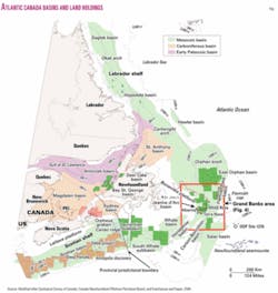
The primary exploration focus for the past 25 years has been in the shallow waters and proven reservoirs of the Jeanne d'Arc basin (Figs. 1-4). However, recent land sales and the locations of speculative seismic programs demonstrate that the industry is ready to expand its efforts into vast untested areas. These include the essentially unexplored plays along the Grand Banks and Labrador continental slope and in intracratonic deepwater basins such as the Orphan basin.

The best evidence of the oil industry's increased interest in offshore Newfoundland potential showed in the 2003 provincial land sale in which a consortium consisting of Chevron Canada, ExxonMobil, and Imperial Oil bid approximately $500 million (US) in work commitments for eight parcels in a previously undrilled deepwater Mesozoic basin, recently named the East Orphan basin.
This was by far the most successful land sale in the history of the Newfoundland and Labrador offshore area and included a record bid of $188 million for one parcel. The first wells on these parcels are expected to be drilled in 2006.
The area's first offshore drilling occurred in 1966, but only 131 exploration wells have been drilled to date on the entire offshore area around Newfoundland and Labrador. The area under Newfoundland and Labrador jurisdiction includes 1.6 million sq km, of which about half is judged to have oil and gas potential.
Offshore drilling has been confined almost entirely to Mesozoic basins, although potential is also recognized in several Paleozoic basins, which in some areas are known to underlie the Mesozoic sediments. Fig. 1 is a regional map showing the distribution of basins and current land holdings in Atlantic Canada.
The area of hydrocarbon potential is vast, and the well density is very low. By comparison, consider that more than 15,000 exploration wells have been drilled in the Gulf of Mexico and more than 3,500 in the North Sea.
While exploration on the Newfoundland and Labrador continental shelf has been constrained by the realities of harsher climatic conditions than some other areas, it has long been proven that seismic and drilling operations can be executed successfully.
It has more recently been demonstrated that profitable field development can be accomplished, as the two producing fields are estimated to be breaking even in the $9-10(US)/bbl range. Operating costs for the producing fields were recently reported by the operators to be $1.50-2/bbl.
Environmental challenges
The areas lying to the east of the island of Newfoundland and off the Labrador coast are subject to sporadic and seasonal iceberg traffic that must be taken into account when exploring or producing in this part of the province's offshore.
The first line of defense against icebergs is to tow them by standby vessels, and the production systems have also been designed to handle a situation where towing is not possible or not effective—an event that has not yet occurred.
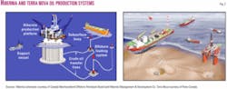
Thus far, the industry has met the iceberg challenge in two ways. Hibernia field, with 865 million bbl originally recoverable in 80 m of water, was developed by a gravity-based system constructed with a protective ice wall (Fig. 2a).
The field's main reservoir, the Hibernia sandstone at 3,800 m subsea, is of exceptional quality with porosities averaging 16% and permeabilities ranging from hundreds of millidarcies to several darcys. The field holds the Canadian record for a flow test (56,000 b/d of oil) from a single zone.
A secondary reservoir, the Avalon sandstone at 2,500 m subsea, contains about 2 billion bbl in place with an estimated recovery rate of 10%.
Both reservoirs are being developed, and current flow rates from the field range from 200,000 to 220,000 b/d of oil. Produced associated gas is being reinjected to maintain reservoir pressure.
Terra Nova field, with 354 million bbl recoverable in 93 m of water, was developed using a floating production, storage, and offloading system (FPSO) for which the subsea wellheads were placed in 10-m deep "glory holes" dredged into the seabed to protect them from iceberg scour (Fig. 2b).
The FPSO is designed for rapid disconnect in the event of an encroaching iceberg, and the flow lines can be flushed to prevent the release of hydrocarbons into the environment. No disconnects have occurred since production began at the field in January 2002. Subsea flow lines, which are partially buried, would be replaced if damaged by an iceberg scour.
Production from the field ranges from 130,000 to 150,000 b/d of oil from a Late Jurassic reservoir (Jeanne d'Arc sandstone at 3,200 m subsea, with 15-20% porosity, 100-1,300 md permeability), and individual wells have tested in excess of 40,000 b/d of oil.
White Rose field, in 120 m of water, includes several oil and gas pools in a sandstone reservoir (Avalon sandstone) deposited during the Early Cretaceous along a north-south trending shoreline that parallels the eastern margin of the Jeanne d'Arc basin.
The oil is contained in a 40 sq km structural-stratigraphic trap with an average of 100 m of Avalon sandstone oil pay at 2,800-3,100 m subsea. Estimated recoverable resources for the entire field include 283 million bbl of oil, 2.7 tcf of natural gas, and 96 million bbl of natural gas liquids.
White Rose operator Husky Energy estimates that it will recover 200-250 million bbl from the portion of the field it is developing (the White Rose South pool). Production of about 92,000 b/d is expected to begin in late 2005 or early 2006 via an FPSO system similar to the Terra Nova setup.
A fourth development is likely to occur at Hebron-Ben Nevis estimated at 414 million bbl recoverable by the CNOPB and 400-700 million by the operator, but this project is currently on hold because of its heavier grade of crude (19-21° gravity). The operator, ChevronTexaco, indicates that it is looking for ways to improve the viability of the project and that possible development scenarios include both fixed and floating production systems.
Grand Banks geology
The Mesozoic basins of the Grand Banks have developed through a series of three rift episodes associated with the breakup of the Pangea supercontinent and opening of the North Atlantic Ocean that began in the Late Triassic and ended in the Late Cretaceous.
Rifting was followed by thermal subsidence which resulted in the deposition of an undisturbed Late Cretaceous section overlain by a thick Tertiary sequence (Fig. 5). Areas of petroleum potential extend from the shallow waters of the banks into the deeper waters of the continental slope as well as to ultradeepwater areas such as the intracratonic East Orphan basin.
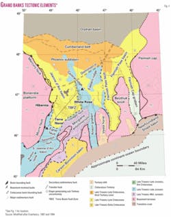
The basins (South Whale, Whale, Horseshoe, Carson, Flemish Pass, and Jeanne d'Arc—Fig. 1), adjacent subbasins (Flemish Pass, Salar), and smaller troughs and cuvettes, have had a common evolution but exhibit some structural and stratigraphic differences. They are separated by elongate basement ridges such as the Central Ridge, and bounded by faults that are linked at depth to the Murre detachment fault (Fig. 4).
Each of these rifting phases was followed by interludes of post-rift thermal subsidence. The initial failed rift episode in the Late Triassic-Early Jurassic was the most important of the three in that it defined the shape, orientation, and size of the main basins. Subsequent rifting episodes rejuvenated tectonic movement throughout the area, leading to greater fragmentation of the preexisting basins.
The associated structuring and refocusing of erosion and sedimentation created numerous reservoirs and traps that are recognized today in the Late Jurassic and Early Cretaceous sequences. The final regional thermal subsidence phase began in the Late Albian. Sediments deposited after this time are remarkably undisturbed, and are broken by only a few late-movement faults and salt diapirs. Several sedimentary structures exist on basin margin and basin floor position.
Jeanne d'Arc basin, proven petroleum system
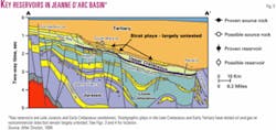
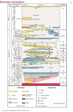
Source rock and maturation. The Kimmeridgian-aged Egret member of the Rankin formation, deposited at the end of a thermal subsidence stage that followed the second rift phase, is the proven oil source rock for all of the significant oil and gas discoveries on the Grand Banks (Fig. 6).
This is a marine, organic-rich (TOC 2-12%) calcareous shale that began generating hydrocarbons in Late Cretaceous, reached peak oil generation during the Eocene, and in places continues to generate oil and gas up to the present. It averages 200 m thick throughout the Jeanne d'Arc basin and has also been encountered in drilling on the Central Ridge and in the Flemish Pass basin.
The Egret member is mature in large areas of the Grand Banks, and seismic character strongly suggests that this source rock will be present in the East Orphan basin. The source rock is also expected to be preserved in a number of seismically recognized depocenters on the southern Grand Banks. The potential for additional source rocks is recognized in the Oxfordian, Early Cretaceous, and Early Tertiary sequences.
Hydrocarbon reservoirs. Stacked sandstone intervals in the Jeanne d'Arc, Hibernia, Catalina, and Avalon formations are proven quality reservoirs (Figs. 5 and 6).
Individual wells have tested in excess of 50,000 b/d from the Hibernia sandstone at Hibernia and in excess of 40,000 b/d from the Jeanne d'Arc sandstone at Terra Nova. Fair to good quality reservoirs are also found in the Voyager and Ben Nevis formations.
Excellent reservoirs are found in Late Cretaceous Dawson Canyon and the Paleocene South Mara formation, but to date only a couple of smaller pools have been encountered at these levels.
Exploratory drilling has focused primarily on the proven reservoirs of the Late Jurassic and Early Cretaceous. However, given the large size of some of the stratigraphic prospects mapped in the Late Cretaceous and Early Tertiary sequences, there is clearly a real and effectively untested potential for large oil and gas pools at these shallower levels.
Hydrocarbon traps. The main structural traps are extensional anticlines, rollovers, faulted anticlines, faulted and tilted blocks, and elongated horsts (Fig. 5).
Numerous salt induced structures such as pillows, domes, diapirs, ridges, allochthonous teardrops, and turtle anticlines are common. The great majority of faults are listric normal faults, but some transfer faults, accommodation zones, and local inversions due to transtension and halokinesis are also observed.
All major traps were found to have a stratigraphic component as the accumulations are contained in continental, deltaic, and shallow marine sandstones onlapping or wrapped over the main structural traps.
Many complex or solely stratigraphic traps remain to be tested by drilling, as well as deeper faulted and rollover structures in the central and northern part of the Jeanne d'Arc basin.
Hydrocarbon seals. Oil and gas accumulations are sealed by thick overlying shales abundant in the Late Jurassic to Late Cretaceous sedimentary successions (e.g., Fortune Bay, White Rose, and Nautilus shales). Intraformational seals are also widespread in the rift-stage clastic sequences. Excellent regional seals are provided by the fine-grained Late Cretaceous Dawson Canyon and the Tertiary Banquereau formations (Fig. 6).
Hydrocarbon migration. Expulsed hydrocarbons have migrated mainly vertically, predominantly along the numerous extensional faults. Some lateral migration occurred locally along the basin flanks. Late migration of hydrocarbons occurred in the basin marginal fans and sand filled canyons.
Exploration potential. The Jeanne d'Arc basin petroleum system is secured by the Egret member, a source rock of world-class quality that generated all the hydrocarbons found thus far in the basin.
The Late Jurassic-Early Cretaceous sandstone reservoirs of the Jeanne d'Arc, Hibernia, Catalina, Avalon, and Ben Nevis formations sealed by intraformational seals and by overlying impermeable successions and sourced from the Egret member shales is the proven, major petroleum system in the Jeanne d'Arc basin. The same source rock has produced accumulations in the Late Cretaceous and Early Tertiary clastic reservoirs and is likely to have also sourced accumulations in the Late Jurassic Voyager formation sandstones.
Exploration in the basin has focused mainly on the proven reservoirs of the Late Jurassic and Early Cretaceous, located in the downthrow of the Murre and Voyager faults and along the Trans-Basin Fault Zone, where most of the large oil discoveries are found (Fig. 4).
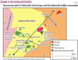
To date 56 exploration wells have been drilled in the basin, resulting in the discovery of 2.1 billion bbl of recoverable oil and 5.4 tcf of recoverable gas. This represents an exploratory well density of 1 well/250 sq km in the Jeanne d'Arc basin.
All exploration thus far has been focused on the oil play, but this may change as investigations are currently under way toward bringing Grand Banks gas to market.
White Rose field alone contains almost 3 tcf of recoverable gas, and operator Husky Energy recently issued a call for proposals on ways and means to monetize the gas. Among other engineering initiatives, the possible use of compressed natural gas tankers to transport the gas is being studied by private companies and Memorial University.
Jeanne d'Arc outlook
Future exploration opportunities in the Jeanne d'Arc basin include:
- Deeper fault blocks in the Trans-Basin Fault Zone and around existing fields (Fig. 4).
- Complexly faulted structures along the basin margins and on parts of the Central Ridge where Late Jurassic successions have not been eroded.
- Early Cretaceous deeper rollovers in the northern portion of the basin.
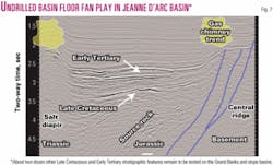
- Late Cretaceous and Early Tertiary basin margin and floor fans (Fig. 6).
- Paleocene and younger sandstones resulting from the erosion of older sandstones and draped over ridges, faulted blocks, and salt diapirs.
- Coarse clastics on the flanks of rotated blocks or in minibasins related to salt structures.
At least 20 Late Cretaceous and Early Tertiary basin margin and floor fan leads and prospects with individual potential running into the hundreds of millions of barrels have been mapped in the Jeanne d'Arc basin alone.
A multipartnered, multiwell program to reduce individual prospect risk and cost is one of the highest impact exploration opportunities available in North America today. It is estimated that in a multiwell program individual wells could be drilled to these shallow-water, 2,000-m TD targets for as little as $10 million.
Other basins
The Laurentian basin is an essentially unexplored basin that connects the Scotian shelf and slope to the southern Grand Banks (Fig. 1).
Until recently, exploration of the basin had been prevented by the need to define the international boundary between France and Canada (the French islands of St. Pierre and Miquelon are located to the north of the basin) and, subsequently, the interprovincial boundary between the provinces of Nova Scotia and Newfoundland and Labrador.
Preliminary seismic mapping and analysis of this 60,000 sq km basin by the Geological Survey of Canada has indicated potential recoverable reserves of 600-700 million bbl of oil and 8-9 tcf gas. Its geological, stratigraphic, and structural characteristics are similar to those of the Scotian margin, probably slightly modified by the presence of the Newfoundland Transfer Fault Zone.
ExxonMobil et al. drilled a single well, Bandol-1, in the French part of the basin and reported it to be a dry hole, releasing no other details. The possible hydrocarbon plays include rollover anticlines in Jurassic and Cretaceous sandstone reservoirs, porosity development in Late Jurassic carbonates, and late Cretaceous to Early Tertiary slope sandstone fans.
The South Whale basin is a Mesozoic sedimentary depocenter situated mostly in shallow and intermediate waters in the southern part of Grand Banks, close to the Newfoundland Transfer Zone.
Located halfway between the currently producing Sable and Jeanne d'Arc basins, the South Whale basin was drilled (14 wells) without success during the 1960s, 1970s, and 1980s. Although source rock has not been encountered in existing wells, the basin is 5-8 km deep and is likely to contain source rock in its deeper parts, and probably Albian source rock along the slope.
In the past, salt anticlines were drilled generally at crestal locations and shallow depths, but all wells were abandoned with only minor shows. Basin remapping projects using newly acquired seismic data and re-evaluation of potential plays with focus in the inter-salt domains or on slope plays has revived hopes and attracted several operators to the area.
The petroleum system of the South Whale basin should include ponded Kimmeridgian source rock (Verrill Canyon shales—the main Scotian shelf source rock, and-or Egret shales—the Northern Grand Banks source rock) in the several mapped sink-synclines.
Late Jurassic and Early Cretaceous reservoirs will be targeted in large fault bounded rollover anticlines and rotated fault blocks in deeper synclines. Sand-rich fans may develop on the basin's southern slope. The Laurentian and South Whale basins are free of iceberg.
The Flemish Pass basin is a Mesozoic basin located to the northeast of the Jeanne d'Arc basin in 1,000 m of water. Four older and two recently drilled wells have proven that the basin has excellent Egret-equivalent source rock and good, thick sandstone reservoirs.
3D seismic data volumes cover almost the entire basin and show large and very large faulted anticlines. The basin is subdivided by transfer faults into several subbasins that had different depositional and structural histories. Two recent wells, Mizzen L-11 and Tuckamore B-27, were abandoned, but noncommercial oil pay was seen on logs at the Tuckamore location.
The Carson/Bonnition/Salar basins on the southeast Grand Banks are a series of interconnected basins located on a divergent margin that extends from the shallow waters of the continental shelf into the deeper waters of the continental rise and slope (200-4,000 m).
Four exploration wells were drilled in the 1970s and 1980s in the shallower area. All four wells were dry holes, and good reservoirs were encountered, but no source rock was intersected.
The industry has licensed two exploration blocks on the slope where Late Cretaceous and Early Tertiary slope fans may constitute viable plays.
Ocean Drilling Program Leg 210, hole 1276, drilled in 2003 on the abyssal plain south of the Flemish Cap, intersected black anoxic organic shales in the Aptian/Albian and to a lesser extent in the uppermost Cretaceous and Paleocene.
These shales were not mature at the location drilled but are likely to be present under a much thicker sedimentary section as one moves onto the continental slope and thereby introduce the possibility of previously unrecognized deepwater source rocks in the southern Grand Banks basins and elsewhere along the continental slope (Fig. 1).
Discussion
Exploratory drilling on the Grand Banks has been at low levels since the late 1980s (only 14 exploratory wells since the beginning of 1988) and predictably has failed to deliver the next big find. Nevertheless, plenty of undrilled potential remains in various basins as discussed above.
One key play over the next few years is expected to be in the largely untested Late Cretaceous and Early Tertiary stratigraphic plays in the Jeanne d'Arc basin, which has a proven and prolific petroleum system. Numerous undrilled prospects have already been mapped in this play, in shallow water locations with target depths in the neighborhood of 2,000 m TD.
Exploration in recent years has been mostly in the form of large 2D spec seismic programs in the Grand Banks and environs, off Labrador, in the deepwater intracratonic East Orphan basin, and along the continental slope. License holders supplement this regional 2D work with 3D surveys on selected blocks.
Oil companies looking to become involved in the Newfoundland and Labrador offshore also have the advantage of access to large volumes nonproprietary seismic data in addition to recently acquired speculative data. New players have the opportunity to choose from large unlicensed areas that have recent coverage by modern seismic, as well as by farmouts from operators that hold large blocks.
Ease of entry to the play is facilitated by government policy by which lands are licensed by work commitment bids supported by a 25% refundable deposit. New infrastructure resulting from the ongoing developments and the establishment of local offices by the major oil-field service companies are providing economies of scale to lower exploration and development costs, and the provincial and federal governments are working with industry to streamline regulatory processes.
Newfoundland and Labrador also has a competitive, profit-sensitive royalty regime that has been well received by the current operators. All of these factors combine to present a unique opportunity to companies seeking the next major North American oil and gas play.
Acknowledgments
Thanks to Larry Hicks, John Hogg, Ian Atkinson, Husky Energy, GSC Atlantic, Memorial University, PPSC, CNOPB, Department of Resources, Government of Newfoundland and Labrador, and GSI.
References can be found in the following web sites that include more readings on the subject: Newfoundland Department of Natural Resources (http://www.gov.nl.ca/mines&en/publications/offshore/); CNOPB (http:// www.cnopb.nfnet.com/); and Geological Survey of Canada, BASINS Website (http://agc.bio.ns.ca/BASIN/FULL).
Next: Geology and potential of the Nova Scotian slope.
The authors

Dr. Michael Enachescu ([email protected]) is Husky Energy senior fellow in exploration geophysics and associate professor at Memorial University of Newfoundland-Pan-Atlantic Petroleum Systems Consortium. He has over 30 years' experience in oil and gas exploration and field delineation, mostly off Newfoundland and Labrador, the Scotian shelf and slope, Beaufort-Mackenzie basins, and various international areas. He did graduate studies in geology and geophysics at the University of Bucharest.

Phonse Fagan is a petroleum geophysics consultant with the Newfoundland and Labrador Department of Natural Resources. He and has more than 20 years' experience in the oil and gas industry, including 5 years with Amoco Canada in Calgary. His work focuses on exploration in the province's land and offshore basins and the use of seismic methods. He is also president of Petro-Ed, a St. John's company that offers short courses to the oil and gas industry. He holds a BSc (Hons.) in physics and mathematics from Memorial University of Newfoundland.