Gulf hydrocarbon trap types provide exploration insights
A great deal of information has been published about oil and gas fields in the Gulf of Mexico, but little has been mentioned about the types of traps present.
The questions for any basin or area is what type traps are most prevalent, what properties are present in each type of trap, which traps have the best results in discovered oil and gas reserves, and how common and how successful are various types of traps by geologic age.
Most of the published data on reservoir properties in the Gulf of Mexico are for discoveries prior to 1998. As later information is not available to the author, these data can be used only as a general guide for the Gulf of Mexico.
Properties reviewed here were calculated for traps of hydrocarbon pool data where a pool was defined as all the pools in a single field. If there were two or three reservoirs of the same age in a field, the data were combined and averaged to get the properties.
Information on various trap data were assembled for 2,601 traps. The four reservoir properties reviewed were depth, pay thickness, areal extent of reservoir, and porosity. Permeability was not included because very little such data have been released for the entire area.
Of the total number of traps for which data were available, only 2,543 traps or 98% were included because they had information available for more than one of the properties. Using only data from traps with more than one property limited the number of traps to those where as much data as possible were collected.
In the literature, only 1,776 traps had discovered oil reserves listed and 2,011 traps had discovered gas reserves listed. As data that were more exact were not available, the percent of oil and gas reserves were used to give a general view of the relationships rather than the incomplete figures.
Traps are usually divided into two general classes, structural and stratigraphic.
Structural traps are those in which some part of the earth has moved and prevented oil flow. These include anticlines, fault traps, salt domes, or combinations of these.
Stratigraphic traps accumulate hydrocarbons because of changes in the reservoir character with a loss of permeability or porosity or the sealing of a reservoir by another rock layer with less porosity or permeability.
Of the 2,543 traps reviewed, 2,442 were structural traps and 101 were stratigraphic traps. Only 1,621 traps had oil reserves reported. Of these, 1,562 were structural traps and 59 were stratigraphic traps.
Of the 1,884 traps with gas reserves reported, 1,804 were structural and 80 were stratigraphic. Structural traps had 94% of the discovered oil reserves and stratigraphic traps had 6%. Structural traps had 97% of the discovered gas reserves and stratigraphic traps had 3%.
Pools in structural traps had an average depth of 7,582 ft and ranged from 950 ft to 22,600 ft; pools in stratigraphic traps had averaged 7,877 ft and ranged from 1,451 ft to 22,000 ft deep.
Porosity in structural traps averaged 29% and ranged from 5% to 38%. Porosity in stratigraphic traps averaged 31% and ranged from 11% to 39%.
Pay thickness in structural traps averaged 278 ft and ranged from 2 ft to 490 ft. Pay thickness in stratigraphic traps averaged 52% and ranged from 2 ft to 2,258 ft.
Productive area in structural traps averaged 976 acres and ranged from 5 acres to 26,404 acres. Productive area in stratigraphic traps averaged 1,240 acres and ranged from 34 acres to 11,845 acres.
The range of depth was 21,650 ft for structural traps and 20,549 ft for stratigraphic traps.
The range of porosity was 33 percentage points for structural traps and 28 percentage points for stratigraphic traps.
The range of pay thickness was 488 ft for structural traps and 2,206 ft for stratigraphic traps.
The range of areal extent of reservoirs was 26,399 acres for structural traps and 11,840 acres for stratigraphic traps.
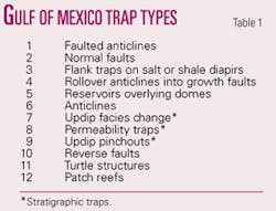
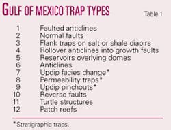
A more detailed list of the types of traps in the Gulf of Mexico shows the most numerous trap types at the top and the rarest trap types at the bottom (Table 1). The code numbers used to identify traps on the accompanying figures are significant only to identify the types of traps.
Structural traps include faulted anticlines, normal faults, traps associated with flanks of salt or shale diapirs, rollover anticlines into a growth fault, reservoirs overlying dome structures, anticlines, reverse faults, and turtle structures (the residual bulges formed between two salt domes). Stratigraphic traps include updip facies changes, permeability traps, updip pinchouts, and patch reefs.
Most traps, 863 or one third of the total, were faulted anticlines (Figs. 1a and 1b). As only one trap was in a patch reef, it was not included in the remainder of this review.
The depth of traps on the Gulf of Mexico shelf through 1998 averaged 7,582 ft and ranged from 950 ft to 22,600 ft (Fig. 2a).
Porosity averaged 31% and ranged from 5% to 39% (Fig. 2b).
Pay zone thickness averaged 269 ft and ranged from 2 ft to 2,258 ft (Fig. 3a). The extreme thickness of 2,258 ft in one permeability trap stands out.
Areal extent of reservoirs averaged 987 acres and ranged from 2 acres to 26,404 acres. In many of the traps, the lowest values were 2, 3, 4, or 5 acres and therefore did not show on the figure (Fig. 3b).
Five of the 11 types of traps held 94% of the oil reserves (Fig. 4a). These are flank traps on salt or shale diapirs, faulted anticlines, normal faults, reservoirs overlying salt domes, and simple anticlines.
Five of the 11 types of traps held 93% of the gas reserves (Fig. 4b). These are faulted anticlines, normal faults, flank traps on salt domes, rollover anticlines into growth faults, and reservoirs overlying salt domes.
The trap types seem to have little effect on reservoir properties and vice versa. Little difference in average porosity is observed as the trap types change. The number of trap types becomes fewer as average depth, average pay thickness, and average area increase.
There was a decrease in the differences between low and high values recorded as the number of traps and pools decreased as shown by the increase in assigned trap type numbers. This may be the result of less data available.
The question arises, does geologic age have any effect on trap types? A total of 802 traps or 32% of the total were Pleistocene in age, 394 (16%) were Pliocene, and 1,306 (51%) were Miocene). Also, 33 traps were Oligocene in age, one trap was Cretaceous, and 15 traps were Jurassic. As Pleistocene, Pliocene, and Miocene traps accounted for 99% of the available information, they were the only ones included.
The shallowest Pleistocene depth was 950 ft and the deepest was 16,441 ft (Fig. 5). The shallowest Pliocene depth was 1,889 ft and the deepest was 19,216 ft. The shallowest Miocene depth was 1,500 ft and the deepest was 18,250 ft.
The lowest porosity in Pleistocene traps was 17% and the highest was 38% (Fig. 6). The lowest porosity in Pliocene traps was 21% and the highest was 36%. The lowest porosity in Miocene traps was 5% and the highest was 39%.
The thinnest Pleistocene pay was 2 ft and the thickest was 379 ft (Fig. 7). The thinnest Pliocene pay was 5 ft and the thickest was 365 ft. The thinnest Miocene pay was 2 ft and the thickest was 2,258 ft.
The smallest productive area in traps of all three ages was 5 ft (Fig. 8). The largest Pleistocene productive area was 14,148 acres; largest Pliocene area was 6,639 acres; largest Miocene area was 17,384 acres. The largest productive area of 26,404 acres was in a trap of Oligocene age.
Pliocene traps had the largest range of depths, smallest porosity range, smallest pay thickness range, and the smallest productive area range of the three age groups. Miocene traps had the largest porosity range, largest pay thickness range, and largest productive area range of the three age groups.
The largest share of oil reserves among the three age groups was in flank traps with salt or shale diapirs (Type 3). No reverse faults had reserves listed for Pleistocene oil traps, and no permeability traps or updip pinchouts had reserves listed for Pliocene oil traps. The percentage of oil reserves decreased with the decline in the number of traps by age (Fig. 9).
The largest percentage of Pleistocene gas reserves was in faulted anticline traps (Type 1). The largest percentage of Pliocene gas reserves was in flank traps with salt or shale diapirs (Type 3). The largest gas reserves were in Miocene traps, and the largest gas reserves in the Miocene were in normal fault traps (Type 2).
No reverse fault traps had reserves listed for Pleistocene gas traps, and no permeability traps or updip pinchout traps had reserves listed for Pliocene gas traps. The percentage of gas reserves decreases with a decline in the number of traps by age (Fig. 10).
The largest number of Pleistocene traps by type was 242 in faulted anticlines, 30% of the Pleistocene total with 12% of the Pleistocene oil reserves and 31% of the Pleistocene gas reserves. The largest number of Pliocene traps by type, 129, was faulted anticlines, 33% of the Pliocene total, with 14% of the Pliocene oil reserves and 25% of the Pliocene gas reserves. The largest number of Miocene traps by type was 472 faulted anticlines, 36% of the Miocene total, with 16% of the Miocene oil reserves and 30% of the Miocene gas reserves.
The largest percentage of oil reserves for all three ages was in flank traps with salt or shale diapirs. The largest percentage of Pleistocene gas reserves was in faulted anticline traps, the largest percentage of Pliocene gas reserves was in flank traps with salt or shale diapirs, and the largest percentage of Miocene gas reserves was in normal fault traps.
Exploration success in any area such as the Gulf of Mexico is more likely if the locations of traps and which type traps give the best results are known. Seismic surveys are used to locate the traps.
The most successful traps for oil in the gulf have been faulted anticlines, normal faults, and flank traps on salt or shale diapirs. The least successful traps have been reverse faults, turtle structures, and patch reefs. The most successful age of traps has been Miocene. Other types of traps than those discussed here may be present, but no data have been released for them. ✦
Bibliography
Bureau of Economic Geology, “Atlas of Northern Gulf of Mexico Gas and Oil Reservoirs,” The University of Texas, Austin, 1999.
Minerals Management Service, “Estimated Oil and Gas Reserves, Gulf of Mexico,” Report 2002-007, Dec. 31, 1999.
The author
F.R. Haeberle ([email protected]) is a consulting geologist who moved to Delaware, Ohio, after 20 years in Dallas. He has worked for Standard Oil Co. of Texas, Atlantic Refining Co., Mobil Oil Corp., Mayfair Minerals, and J.J. Lynn Oil Division. He holds BS and MS degrees in geology from Yale University and an MBA degree in finance from Columbia University Graduate Business School.


