Frontier South, East Falkland basins reveal important exploration potential
Recent work by Borders & Southern Petroleum PLC has shown that the Cretaceous-Tertiary East Falkland and South Falkland basins, respectively east and south of the Falkland Islands, have the potential to become a major hydrocarbon province.
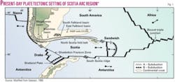
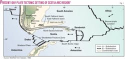
The Tertiary South Falkland basin, located some 200 km south of the Falkland Islands, and the underlying Mesozoic East Falkland basin, located due south and east of the Falkland Islands, have recently been the focus for renewed exploration activity by UK and Falklands based independent explorers Borders & Southern Petroleum PLC and Falkland Oil & Gas Ltd., respectively (Figs. 1 and 2).
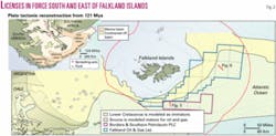
The two companies have licensed the majority of these two superimposed basins in the territorial waters of the Falkland Islands (Fig. 3). Previous drilling in the Falkland Islands Designated Area has been restricted to the North Falkland graben (Fig. 2) north of the islands. This is a separate basin (part of a continental rift system, Fig. 2) with a wholly independent petroleum system unrelated to that developed in the South Falkland and East Falkland basins.
While both basins south and east of the Falkland Islands remain untested by commercial drilling, the basins are considered to be located on part of a highly productive geological trend of basins that formed during the Mesozoic breakup of Gondwanaland, as the continents of South America, South Africa, and Antarctica separated (Fig. 2 inset).
The most westerly of the basins in this productive trend is the Magallanes basin, where commercial production from Lower Cretaceous/Upper Jurassic Springhill continental sandstones was established as early as 1949. By the 1970s exploration moved to the shallow waters offshore.
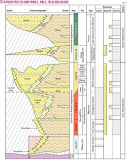
In 1983, Total SA discovered Carina gas-condensate field, at several trillion cubic feet recoverable the basin’s largest field. Total brought Carina on production in 2005. To date in excess of 1,200 new field wildcats have been drilled in the basin, resulting in the discovery of 1.2 billion bbl of oil and 25 tcf of gas. The vast majority of the discovered hydrocarbons have been typed back to Early Cretaceous marine shales of the Lower Inoceramus formation (Fig. 4).
In the early 1980s the focus of exploration activity shifted eastwards to the Malvinas basin, separated from the Magallanes basin by the Dungeness arch. In 1980-82, 12 new field wildcats were drilled in the basin, all targeted at the same Lower Cretaceous/Upper Jurassic sandstone play that had been proven successful in the Magallanes basin.
The drilling resulted in four discoveries containing oil, gas, and condensate. Flow rates of up to 21 MMscfd of gas, 3,021 b/d of oil, and 608 b/d of condensate were achieved from the Springhill continental sands. Hydrocarbons have been geochemically typed back to the same Lower Inoceramus source system as proven in the Magallanes basin.
The most easterly portion of this Gondwanan breakup basin complex is the Bredasdorp basin system of South Africa. To date drilling has been restricted to the shallow-water shelf, where several significant gas fields and smaller oil discoveries have been made. Recent activity has seen the industry focus on the deepwater areas. As in the Argentinean basins, the Early Cretaceous source system appears to have been responsible for charging all discoveries made to date.
Both the Jurassic/Cretaceous East Falkland basin, which linked the Malvinas basin to the Bredasdorp basin, and younger Tertiary South Falkland basin remain untested by commercial drilling. However, by analogy with the producing basins to the east and west, these basins are considered to have a high chance of success as they are geologically linked by the same prolific Early Cretaceous source system.
Regional geology
The East Falkland basin formed during the Mesozoic breakup of the Gondwanan supercontinent.
The basin was initiated by extensive rifting during the Middle Jurassic with the development of a series of grabens that extended from the Magallanes basin onshore Argentina through to the Bredasdorp basin in South Africa.
In the west, the Magallanes and Malvinas basins were mainly filled with a series of tuffs, tuffaceous sandstones, rhyolites, and minor lacustrine shales of the Tobífera formation (Fig. 4). The synrift interval in the East Falkland basin is interpreted from seismic data to comprise volcaniclastics that pass lateral into more marine dominated clastics.
This Synrift I megasequence reaches up to 3,000 m in the deepest parts of the basin. The overlying Postrift I megasequence comprises of a Late Jurassic transgressive package containing a continental to parallic basal transgressive sand (Springhill formation), which forms the major reservoir in the Argentinean basins.
During the earliest Cretaceous, rifting was renewed in response to the opening of the South Atlantic and the drift apart of the Falklands microplate from the South African continent.
Across the Falklands microplate this rifting is expressed as an extensive regional breakup unconformity that was subsequently transgressed by a second continental to parallic sand (Springhill formation). This Synrift II megasequence ranges in age from Valanginian (?) to Aptian, with its top being marked by a major maximum flooding surface.
In the overlying Postrift II megasequence, restricted conditions led to the deposition of the principle marine source rock. Following the late Aptian maximum flooding the style of deposition switched from predominantly transgressive to predominantly regressive with more open marine conditions.
An extensive progradational shallow marine shelf developed around the margins of the emergent proto-Falkland Islands, which continued to develop until the latest Cretaceous when the Postrift II megasequence was terminated by the formation of the overlying foreland basin.
In contrast, the South Falkland basin is mainly a Tertiary foreland basin that developed along the southern margin of the Mesozoic East Falkland basin (Figs. 1 and 3). The basin was initiated possibly as early as the Late Cretaceous in response to the early flexural loading of the East Falkland basin during compression associated with the Andean Cordillera but became most active during the Mid-Cenozoic in response to compression associated with the formation of the Scotian Sea to the south (Fig. 1).
Major compression appears to have ceased during latest Miocene times, coincident with the cessation/switching of seafloor spreading to the south. The basin extends from the Magallanes part of the Andean foreland to the edge of the Falklands microplate, a distance of over 2,200 km.
The fill of the basin, which reaches up to 4 km directly south of the islands, comprises exclusively deep marine clastics derived from the Falkland Islands massif to the north and the uplifting Andean mountain chain to the west, with a minor contribution derived from the south.
Hydrocarbon potential
Source rocks
Source rocks exist at a number of stratigraphic levels in the East Falkland basin.
Thin lacustrine source intervals are recognized in the Synrift I megasequence (Fig. 4) in the Magallanes basin and are considered to have moderate potential.
Offshore shales deposited during the initial early Cretaceous transgression and believed to be a lateral equivalent of the Springhill sandstone have limited potential.
Late Jurassic to Aptian anoxic marine shales deposited as part of the Postrift I/Synrift II megasequences form the principle source rocks recognized with the basin complex (Fig. 4). This Lower Inoceramus source system has been proven present and effective in both the Magallanes and Malvinas basins and has been proven to be present in the East Falkland basin by DSDP wells 330 and 511 (Fig. 1).
DSDP Well 330 penetrated a 225 m thick succession of sapropelic claystones that ranged in age from Oxfordian to latest Aptian. An average TOC of 2.5%, maximum of 5%, was reported, with the kerogens being of a mixed Type II-Type III, which is interpreted to be capable of generating a relatively large proportion of liquid hydrocarbons.
DSDP Well 511 penetrated an age and facies equivalent source section that measured at least 150 m thick as the base was not reached. In this well the facies change at the top of the source rock that marks the switch from Aptian sapropelic anoxic claystones to early Albian oxidized nannofossil chalks is clearly seen and corresponds in the transition from the Synrift II to Postrift II megasequences.
The kerogens are composed of both terrestrial and aquatic, Type II dominated organic matter with TOCs of 3-8%. The source interval has an overall average TOC of 3.5% and is expected to be predominantly oil-prone. The interval has a potential hydrocarbon yield (S1+S2) of between 14 and 41 kg/ton with an interval average of 25 kg/ton.
Hydrocarbon charge
Little data exist to calibrate source maturity in the East Falkland basin.
Simple 2D basin modeling of the main Lower Inoceramus marine source rock in the East and South Falkland basins suggests that the source rock could have entered the oil expulsion window with as little as 2.7 km of overburden, with the base of the oil window being reached with as much as 4.2 km of overburden. Fig. 2 shows the areal extent where the Lower Cretaceous Inoceramus source system is modeled in the oil and gas windows.
The modeling indicates that the Aptian source may have entered the hydrocarbon generation window by as early as the Late Cretaceous and has continued to expel up to today. Hydrocarbons generated in the East Falkland basin are expected to have charged traps both in that basin as well as the overlying Tertiary South Falkland foreland basin.
The presence of a working source in the basins is further supported by the presence of numerous seismic amplitude anomalies (including gas chimneys and possible direct hydrocarbon indicators), many of which are interpreted to be related to hydrocarbon charge, as well as the presence of an extensive gas hydrate layer found in rocks ranging in age from Late Cretaceous to Late Tertiary. The wide range in age of the host rocks suggests a thermogenic rather than biogenic origin for the gas.
Main play fairways
Several play fairways are recognized in the East Falkland basin and in the underlying South Falkland basin.
The continental to shallow marine Springhill formation sands, Mid-Cretaceous submarine fans, and Late Cretaceous slope channels all occur in the East Falkland basin, while the overlying Tertiary foreland South Falkland basin contains an extensive and thick Tertiary deep marine clastics play fairway. Each key play fairway is described below.
1. Springhill sandstones, Postrift I megasequence.
The Upper Jurassic Springhill formation play fairway comprises transgressive sands located at the base of the transgressive wedge in the Postrift I megasequence (Fig. 4), sealed by Late Jurassic mudstones and sourced from laterally equivalent and overlying Late Jurassic/Early Cretaceous anoxic shales of the Lower Inoceramus formation.
The reservoir comprises nonmarine to parallic sands deposited during the widespread transgression of the top Synrift I surface. Sands of this age have been proven in DSDP Well 330 in the East Falkland basin as well as by numerous wells in the Magallanes and Malvinas basins to the west.
In DSDP Well 330 the interval reaches 33 m in thickness, comprising a complexly interbedded sequence of terrigenous silty sandstones and sandy siltstones beds that contain an abundance of plant remains and lignite. The sandstones are fine-medium grained but dominantly poorly sorted. Caprock is provided by the Late Jurassic marine shales.
2. Springhill sandstones, Synrift II megasequence.
A younger, Synrift II basal transgressive sand, deposited during the separation of the Falklands microplate from the South African mainland during the early Cretaceous (Fig. 4), forms one of the principle targets in the East Falkland basin.
Wells drilled in the Malvinas basin yielded sandstone porosities of 8-32% and permeabilities of up to 2,300 md.
The reservoir is highly diachronous and is likely to range in age from Berriasian to latest Aptian, being terminated by a maximum flooding surface. The reservoir is sealed by lateral equivalent offshore mudstones of the Pampa Rincon formation and top sealed by early Cretaceous shales of the Lower Inoceramus formation, which also forms the principle source rock.
The play fairway has not been tested in the East Falkland basin. In the Malvinas basin 14 new field wildcats have been drilled to date resulting in four discoveries from Springhill sandstone reservoirs. Farther to the west the play fairway is productive throughout the Magallanes subbasin where it contains the vast portion of the discovered resource (around 5 billion boe).
3. Mid-Cretaceous submarine fans, Postrift II megasequence.
The Postrift II megasequence in the East Falkland basin contains a series of major progradational sequences of Mid to Late Cretaceous age (Fig. 4).
Several of the sequences in this megasequence show onlapping deep marine wedges located at the base of the coeval slope and are interpreted to represent onlapping, basinal deep marine clastics. While reservoirs in this interval have not been proven effective in either the Magallanes or Malvinas basins similar age basin floor fan reservoirs have been reported in the Bredasdorp basin.
Caprock is expected to be provided by the distal toesets of the overlying highstand system tract. These onlapping sequences have the potential to form extensive proximal pinchout traps along the base of slope.
4. Late Cretaceous slope channels (late Postrift II/early Foreland Fill megasequence.
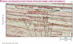
By Latest Cretaceous times early thrust loading caused flexing of the East Falkland basin and the initial regional uplift of the Falkland Islands area, resulting in the deposition a thick slope apron. Numerous potential slope channels are recognized in this slope apron, especially where they are highly reflective and anomalous (Fig. 6).
While shallow-water reservoirs of this age have been reported from both the Magallanes and Malvinas basins, the deeper water equivalents have yet to be tested. Caprocks are expected to be formed by marine shales.
5. Foreland Fill-deep marine clastics.
The Foreland fill play fairway comprises deep marine sands deposited in front of the evolving North Scotian foldbelt in the South Falkland basin (Fig. 3).
The sands are interpreted to have been derived from either the erosion of the updip, emergent Falkland Massif to the north and/or westwards from erosion the uplifted Andean foldbelt and deposited in a major east-west orientated basin. The Tertiary foreland reservoirs are expected to form laterally extensive turbidite sands that progressively lap out onto the evolving southerly dipping flexural bulge.
Several prominent submarine channels are also recognized where reservoir sands might be expected. Reservoir quality is expected to be good given the lack of burial. It is anticipated that the sands will be sealed by intraformational deep marine shales and charged directly from the underlying Early Cretaceous anoxic shales of the Lower Inoceramus formation.
Only one well, Ciclon x-1, has penetrated the foreland play fairway in the Malvinas basin. It found a 558 m thick sequence of early Paleogene coarse-grained, glauconitic, deep marine sandstones and shales located close to the northern edge of the foreland basin.
Repsol YPF SA and its partners are currently exploring an extension of this play fairway in Argentinean blocks CAA40 and CAA46 (Fig. 2). Repsol acquired a 2,400-sq-km 3D seismic survey over part of this play fairway in early 2005.
Traps
East Falkland basin
Tilted fault blocks form one of the principle targets in the East Falkland basin. The trap type has been proven effective in both the Magallanes and Malvinas basins, where it contains the vast majority of the hydrocarbons discovered to date (Fig. 3).
The potential for stratigraphic traps is recognized throughout the Mesozoic and Tertiary fill of the East Falkland basin. Trap types range from stratigraphically trapped upper slope submarine channels (Fig. 6) to the proximal lapout of shallow to nonmarine sands of the Springhill formation. Basin floor submarine fans that lap out at the foot of slope are also recognized on offer potential upside.
A prominent basin margin rollover is recognized along the northwestern boundary of the East Falkland basin. It is likely that both downthrown three-way and four-way closures may be present in the hanging wall of this major fault.
An extensive Late Cretaceous growth fault system is recognized in the East Falkland basin. It is expected that these faults may have created significant accommodation space on the upper slope, enabling the trapping of considerable volumes of turbidite sands. Potential stratigraphic traps may have formed where these sands lap out onto the rotated subsurface.
South Falkland basin
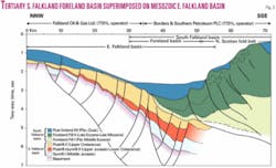
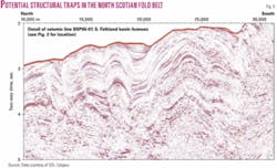
Frontal folds with associated four-way dip closures are recognized along the compressional front in the foreland basin. These simple structures form robust, attractive primary exploration targets (Fig. 5).
Numerous large (up to 150 sq km) compressional folds with four-way dip closures are recognized in the South Falkland basin (Fig. 5). The folds are predominantly in Tertiary deep marine clastics of the Foreland fill megasequence. Reservoirs comprise either areally extensive sheet-like basin floor fans or channel sands deposited in erosive-based channels. Where the channels cross structural noses a stratigraphic trapping may be present.
Large thrusted folds are also seen through the South Falkland basin, giving rise to three-way fault bounded closures (Fig. 5). Three-way subthrust closures are also abundant and form the third principle trap type.
The potential for stratigraphic traps is recognized throughout the Tertiary fill of the South Falkland basin. Trap types range from stratigraphicaly trapped submarine channels and regional pinchout of basin floor fans to localized lapout of deep marine clastics reservoirs onto the flanks of synsedimentary structures in the foreland basin.
Mesozoic tilted fault blocks form the deepest trap type in the South Falkland basin. The trap type has been proven effective in both the Magallanes and Malvinas basins, where it contains the vast majority of the hydrocarbons discovered to date.
Exploration summary
The East Falkland and South Falkland basins represent highly prospective, untested portions of an extensive basin complex that extended from Argentina to South Africa prior to the breakup of Gondwana.
Where exploration has taken place on this trend in excess of 6 billion boe have been discovered. While the Falkland Islands part of this basin system can be classed as frontier from a drilling density viewpoint, it lies on a highly productive geological trend with several working and postulated petroleum systems. All of the key ingredients for the presence of new petroleum province are recognized.
The presence of a working petroleum system in these two basins is evidenced by the presence of an Early Cretaceous marine source rock of world class potential as penetrated by DSDP wells 511 and 330, the identification of numerous geophysical anomalies consistent with a working petroleum system (e.g., bright spots, flat spots, gas chimneys, and seeps), and the extensive distribution of gas-hydrates that appear to have a thermogenic origin.
Reservoirs in the East Falkland basin are likely to range in age from Upper Jurassic through to Early Tertiary in depositional environments ranging from continental to upper slope, while in the South Falkland basin the predominantly Tertiary reservoirs are expected to comprise deep marine clastics deposited in the developing foreland basin reservoirs a range of play types.
Numerous, large simple structures have been identified in the basins and help provide a variety of independent play types to test.
Current activity
Recent activity in the two basins has seen both Borders & Southern Petroleum and Falkland Oil & Gas Ltd. acquire extensive new 2D seismic data.
Geophysical Services Inc., Calgary, using its GSI Admiral vessel, has acquired the data for both companies. These data will be used to refine the play fairways outlined above and to define prospects and leads. Both companies plan to bring in partners prior to the drilling phase of their respective exploration programs. ✦
Bibliography
Galeazzi, J.S., “Structural and stratigraphic evolution of the western Malvinas basin, Argentina,” AAPG Bull., Vol. 82, No. 4, April 1998, pp. 596-636.
The author
Philip Fish ([email protected]) has been exploration manager for Borders & Southern Petroleum PLC since its inception in 2004. The company successfully floated on the London AIM stock market in May 2005. Before joining the company he worked as a consulting geophysicist and also as an exploration geophysicist for Britoil/BNOC, BP, Amoco, and Enterprise Oil.
