Diagenetic Reservoirs-2: Data integration vital in exploring for diagenetic hydrocarbon traps
Basement-involved faults, particularly faults that are reactivated over time, form some of the most important zones of vertical permeability.
Some of the most significant of these faults are developed above boundaries that separate differing basement terranes. Because these terrane boundaries typically juxtapose basements with different compositions, crustal thicknesses and heat flow regimes, they are especially prone to minor reactivation. These zones, as well as other basement-involved faults, are most likely to be reactivated during periods of orogenic activity that commonly coincide with periods of enhanced basinal fluid flow.21
Since the orientation and magnitude of stresses at the time of fault reactivation generally are different from the stresses that originally formed the fault, faults usually are reactivated with a component of strike-slip displacement. Reflecting this strike-slip component, faults in the sedimentary section typically form a discontinuous en echelon fault-array above a through-going basement fault (Fig. 4). Dolomitization along these discontinuous faults may produce a series of compartmentalized en echelon reservoirs separated by nonreservoir rock such as in Albion-Scipio field described in the first part of this two-part article (Fig. 6).
Bowling Green field
As well as showing the fluid flow focusing effect of a regional arch, Northwest Ohio also provides an important example of the fluid focusing provided by a reactivated basement fault.
The Bowling Green fault of northwestern Ohio is a high-angle fault that is developed in Paleozoic strata above the Grenville front (Fig. 2). This terrane boundary separates Middle Proterozoic sediments and volcanic rocks to the west from medium and high grade metamorphic rocks of the Grenville province to the west. The fault is a high-angle fault that has up to 500 ft (150 m) of vertical separation.
Based on seismic data, secondary structures, isopach maps, and outcrop data, the fault appears to have undergone periods of normal, reverse, and left-lateral displacement.9 22 23
Contrasting unit thicknesses and facies differences across the fault indicate Ordovician and possibly Cambrian movement. Later significant activity on the fault, which offsets Silurian strata at the surface, may have occurred during the Pennsylvanian Alleghenian or possibly the Devonian Acadian orogeny.22
Along the broad fault zone there is strong fracturing, intense dolomitization, brecciation, solution of limestone, and minor MVT mineralization that locally affects the entire Trenton formation and underlying Black River formation.24
Within the center of the fault zone, late-stage cementation occludes earlier developed porosity and greatly reduces permeability. Farther away, dolomite and limestone interfinger, and at still greater distances from the fault the Trenton and Black River formations are entirely limestone.9 25
Oil was trapped on both sides of the fault zone. Porous Trenton dolomites on the upthrown, east side of the fault are juxtaposed across the fault against Late Ordovician Cincinnati Group shales while on the west side of the fault porous Trenton is juxtaposed against impermeable Trenton limestones.
The best production was on the downthrown western side of the fault where hydrothermal dolomite porosity is associated with a series of fractured and faulted en echelon folds.9 Production records from the field are incomplete, but production is estimated to have been as much as 225 million bbl of oil and an unknown amount of natural gas.26
Fields at fault intersections
Vertical permeability along fault zones is highly variable.
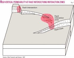
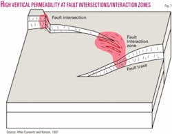
An extensive compilation of the controls of modern hydrothermal springs and outflow zones shows that many of these features occur at fault intersections and fault interaction zones where faults come close together but do not intersect27 (Fig. 7). These zones have enhanced permeability because of greater fracture intensity and in carbonate rocks are favorable locations for the development of localized hydrothermal dolomite reservoirs.
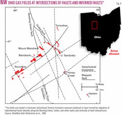
Several small to moderate sized-gas fields within the Trenton formation south of the Lima-Indiana trend in Northwest Ohio clearly illustrate this relationship (Fig. 8). These fields are distributed across the southeastern flank of the Findlay arch and the margin of the Trenton platform. They are all located near the intersections of north-northwest trending faults and northeast-trending faults inferred from both well-based structure maps and gravity and magnetic data.28
The vertical displacement of the northeast trending faults is small, but fracturing apparently was sufficient to enhance vertical permeability and allow migration of hydrothermal brines and natural gas. The largest of the faults, the Outlet fault, strikes north-northwest and intersects the Bowling Green fault previously described.
It is likely that hydrothermal fluids and natural gas migrated southeastward along both the Bowling Green and Outlet faults and then moved along the northwesterly striking faults that intersect them. The commercial gas accumulations are associated with these fault intersections (Fig. 8).
Karst and dolinen
Vertical karst features and dolinen form vertical conduits for fluids on a local to oil field scale.
Basinal brines that move up these features typically move laterally into permeable carbonate units creating a broader zone of solution and dolomitization.
Pine Point MVT deposits
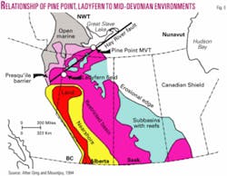
Because of open pit mining and extensive core drilling, the Pine Point MVT lead-zinc deposits of the Northwest Territories of Canada provide extremely well documented and exposed examples hydrothermal dolomite and the role of karst in localizing hydrothermal fluids associated with a reactivated basement-involved Hay River/MacDonald fault zone (Fig. 9).29
Substantial amounts of late-stage bitumen occur in vugs in the dolomite and thus the deposits can be viewed as an example of an exposed hydrothermal dolomite-hosted hydrocarbon reservoir. Specifically, the deposits provide analogs for Ladyfern gas field located 350 miles (560 km) to the southwest along the continuation of the Hay River Fault Zone.
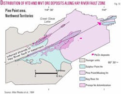
The ore deposits occur within two large linear zones of hydrothermally dolomitized Middle Devonian carbonate strata29 (Fig. 10). These dolomitized zones are exposed examples of altered rock similar to the reservoir rock within many hydrothermally hosted oil fields.
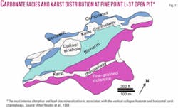
Within these zones the most intense alteration and mineralization is controlled by both vertical and horizontal karst systems as well as the original depositional facies of the carbonate rocks (Fig. 11). The karst distribution also is strongly controlled by the original depositional facies of the carbonate strata.
This karst is best developed beneath a regional unconformity at the base of the Middle Devonian Watt Mountain formation, which is believed to have localized the karst development.29 However, mineralized and dolomitized karst extends upward across the unconformity into younger units.3 This suggests that the younger karst or collapse breccia formation that may have resulted from hydrothermal solution that was focused by older karst formed by meteoric fluids.
Karst and diagenetic reservoirs
Three-dimensional seismic surveys are the best way to identify dolinen and collapse structures in the subsurface, but results of few surveys over fields involving hydrothermal dolomite have been described.
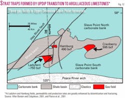
These features probably are important at the recently discovered (year 2000) Ladyfern gas field located on the northern Alberta-British Columbia border (Fig. 12). The field is one of three large gas fields within bioclastic grainstones and packstones of the Upper Devonian Slave Point formation30 31 (Fig. 9).
Trapping in these fields is controlled by an updip transition to impermeable Slave Point argillaceous limestones and by a topseal provided by shales of the Beaverhill Lake formation.
Well productivity is exceptionally good at Ladyfern field because permeability and porosity are greatly enhanced by dissolution, hydrothermal dolomitization, brecciation, and fracturing. The field is located above normal faults that splay off from the Hay River fault zone.
Enhanced porosity and permeability are associated with these fault trends. The thickest and best reservoir sections are associated with “dissolution pipes” that allowed fluids to rise vertically and spread laterally in reservoir prone units.30 Some of these pipes may be related to fracturing at fault intersections, but others are probably formed by upward stoping of karst initially developed in the underlying Middle Devonian Elk Point Group as at Pine Point.3
A second example of a field formed by dolinen localized along a fault is provided by a 3D survey of York field in northwestern Ohio.32 There, a series of six aligned circular features in the Trenton formation was defined along a linear trend paralleling a basement-involved fault. Subsequent drilling determined that the circular features were productive gas reservoirs hosted in brecciated, dolomitized Trenton formation.
Production rates from individual wells in other hydrothermal dolomite reservoirs such as Deep River oil field in eastern Michigan are highly variable.33 The highly productive wells in these fields could be related to karst but can be explained by the presence of other types of localized highly permeable zones as well.
Exploration approach
Systematic exploration for the subtle hydrothermal reservoirs described above has been applied in only a few basins.
Many of the discovered fields hosted by these reservoirs have been found by accident such as Albion-Scipio and Deep River in Michigan. However, evidence indicates that these types of fields 1) occur in many basins and 2) have good production rates and 3) range up to fields of large size (Albion-Scipio 130 million bbl, >205 bcf; Ladyfern 700 bcf-1 tcf).12 31
Deliberate search for fields of this type requires a new exploration mindset. In basins where hydrothermal reservoirs are not recognized, exploration might start with a search for evidence of basinal hydrothermal systems. This evidence may include the presence of MVT type mineralization around the basin margins, evidence of widespread diagenetic alteration in the basin, or paleotemperature data that are higher than predicted from reasonable geothermal gradients or burial depths.
If such indications are present, the next step is to identify and determine the distribution of deep aquifers in the basin that are likely candidates for transporting large amounts of hot basinal brines. Core or cuttings samples from aquifers that have been major transporters of brine will show evidence of secondary porosity or cementation and other forms of diagenesis.
Regional structure contour maps of the aquifer can indicate regional structures such as arches that may focus fluid flow. Knowledge of the structural configuration of the basin at the time of major hydrothermal fluid flow would be the preferable ideal. In some cases this timing may be determined from radiometric dating in nearby MVT ore districts, dating of potassium-rich diagenetic clays related to the period of fluid flow, or from the timing of the resetting of paleomagnetic poles within the affected units. If timing can be determined, isopach maps are useful in showing the basinal geometry at that time.
Once areas of potential focused regional flow are identified, efforts should be directed toward finding areas where local vertical flow of basinal brines is enhanced. Classic mapping techniques are valuable for identifying features such as the lateral termination of aquifers and permeability breaks in regional seals produced by unconformities, pinchouts, and facies changes.
Potential-fields data provide a low cost means of mapping the trends of basement-involved faults and fault intersections. Traces of saddle or baroque dolomite or MVT mineralization noted in sample logs may further help to focus efforts.
Integration of such studies should be sufficient to identify areas for more detailed exploration. A geographic information systems (GIS) approach is valuable for both gathering properly scaled and oriented map data and overlaying various types of maps to identify favorable areas for more detailed exploration.
Once favorable areas for the development of diagenetic traps have been identified, high frequency 2D seismic with small sampling rate have proved to be the best tool at identifying subtle sags and dim zones associated with hydrothermal dolomite reservoir development. Surface geochemical sampling across zones of interest recognized from seismic may be useful in further evaluating any resulting leads. ✦
References
1. Mountjoy, E.W., and Amthor, J.E., “Has burial dolomitization come of age? Some answers from the Western Canada sedimentary basin,” in Purser, B., Tucker, M., and Zenger, D., eds., “Dolomite: A volume in honour of Dolomieu,” International Assoc. Sedimentologists Spec. Pub. 21, 1994, pp. 203-229.
2. Leach, D.L., and Sangster, D.F., “Mississippi Valley-type lead-zinc, deposits,” in Kirkham, R.V., Sinclair, W.D., Thorpe, R.I., and Dukes, J.M., eds., “Mineral Deposit Modeling: Geological Association of Canada Sp. Paper 40, 1993, pp. 289-314.
3. Qing, H., and Mountjoy, E.W., “Origin of dissolution vugs, caverns, and breccias in the Middle Devonian Presqu’ile barrier, host of Pine Point Mississippi Valley-type deposits,” Economic Geology, Vol. 89, 1994, pp. 858-876.
4. Kesler, S.E., “Appalachian Mississippi Valley-Type deposits: Paleoaquifers and brine provinces,” in Sangster, D.F., ed., “Carbonate-Hosted Lead-Zinc Deposits,” Soc. Economic Geologists Sp. Pub. No. 4, 1996, pp. 29-57.
5. Pitman, J.K.,Goldhaber, M.B., and Spöetl, C., “Regional diagenetic patterns in the St. Peter Sandstone: Implications for brine migration in the Illinois basin,” US Geological Survey Bull. 2094-A, 1997, pp. A1-A17.
6. Hanor, J.S., “Controls on the solubilization of Lead and Zinc in basinal brines,” in Sangster, D.F., “Carbonate-Hosted Lead-Zinc Deposits, Society of Economic Paleontologists and Mineralogists Spec. Pub. 4, 1996, pp. 483-500.
7. Sverjensky, D.A., “Genesis of Mississippi Valley-type lead-zinc deposits: Annual Review of Earth and Planetary Science,” Vol. 14, 1986, pp. 177-199.
8. Kent, W.N., and Hickman, R.G., “The hydrothermal hydrocarbon system,” AAPG Bull., in press.
9. Wickstrom, L.H., Gray, J.D., and Stieglitz, R.D., “Stratigraphy, structure, and production history of the Trenton limestone (Ordovician) and adjacent strata in northwestern Ohio,” Ohio Division of Geological Survey Special Paper 143, 1992, 78 pp.
10. Baranoski, M.T., “Structure contour map on the Precambrian unconformity surface in Ohio and related basement features,” Ohio Div. of Geological Survey Map PG-23, 2002, 1:500,000.
11. Longman, M.W., and Palmer, S.E., “Organic geochemistry of mid-continent Middle and Late Ordovician oils,” AAPG Bull., Vol. 71, 1987, pp. 938-950.
12. Hurley, N.F., and Budros, R., “Albion-Scipio and Stoney Point Fields-U.S.A.,” in Beaumont, E.A., and Foster, N.H., compilers, “Stratigraphic Traps I: AAPG Treatise of Petroleum Geology Atlas of Oil and Gas Fields,” 1990, pp. 1-37.
13. Cole, G.A., Drozd, R.J., Sedivy, R.A., and Halpern, H.I., “Organic geochemistry and oil-source correlations, Paleozoic of Ohio,” AAPG Bull., Vol. 71, 1987, pp. 788-809.
14. Elliott, W.C., and Aronson, J.L., “The timing and extent of illite formation in Ordovician K-bentonites at the Cincinnati Arch, the Nashville Dome, and north-eastern Illinois basin,” Basin Research, Vol. 5, 1993, pp. 125-135.
15. Carter, T.R., Trevail, R.A., and Easton, R.M., “Basement controls on some hydrocarbon traps in southern Ontario, Canada,” in van der Pluijm, B.A., and Catacosinos, P.A., eds., “Basement and Basins of Eastern North America,” GSA Spec. Paper 308, 1996, pp. 95-107.
16. Cohee, G.V., “Cambrian and Ordovician rocks in recent wells in southeastern Michigan,” AAPG Bull., Vol. 31, 1947, pp. 293-307.
17. Wilcox, R.E., Harding, T.P., and Seely, D.R., “Basic wrench tectonics,” AAPG Bull., Vol. 57, 1973, pp. 74-96.
18. Ragan, V.M., Coveney Jr., R.M., and Brannon, J.C., “Migration paths for fluids and northern limits of the Tri-State district from fluid inclusions and radiogenic isotopes,” in Sangster, D.F., ed., “Carbonate-Hosted Lead-Zinc Deposits,” Soc. Economic Geologists Sp. Pub. No. 4, 1996, pp. 419-431.
19. Brockie, D.C., Hare Jr., E.H., and Dingess, P.R., “The Geology and Ore Deposits of the Tri-State District of Missouri, Kansas, and Oklahoma,” in Ridge, J.D., ed., “Ore Deposits of the United States, 1933-1967, Vol. 1,” American Institute of Mining, Metallurgy and Petroleum Engineers, 1968, pp. 400-430.
20. Fowler, G.M., “Oil and oil structures in the Oklahoma-Kansas zinc-lead mining field,” AAPG Bull., Vol. 17, 1933, pp. 1,436-45.
21. Oliver, J., “Fluids expelled tectonically from orogenic belts: Their role in hydrocarbon migration and other geologic phenomena,” Geology, Vol. 14, 1986, pp. 99- 102.
22. Onasch, C.M., and Kahle, C.F., “Recurrent tectonics in a cratonic setting: An example from northwestern Ohio,” GSA Bull., Vol. 103, 1991, pp. 1,259-69.
23. Ramsay, D.W., and Onasch, C.M., “Fluid migration in a cratonic setting: The fluid histories of two fault zones in the eastern mid-continent,” Tectonophysics, Vol. 305, 1999, pp. 307-323.
24. Keith, B.D., and Wickstrom, L.H., “Lima-Indiana trend-U.S.A., Cincinnati and Findlay arches, Ohio and Indiana,” in Beaumont, E.A., and Foster, N.H., compilers, “Stratigraphic Traps III: AAPG Treatise of Petroleum Geology Atlas of Oil and Gas fields,” 1992, pp. 347-367.
25. Wickstrom, L.H., and Gray, J.D., “Geology of the Trenton Limestone in northwestern Ohio,” in Keith, B.D., ed., “The Trenton Group (Upper Ordovician Series) of eastern North America: Deposition, diagenesis, and petroleum,” AAPG Studies in Geology Series 29, 1988, pp. 159-172.
26. Keith, B.D., “Reservoir resulting from facies-independent dolomitization: Case histories from the Trenton and Black River carbonate rocks of the Great Lakes area,” in Keith, B.D., ed., “The Trenton Group (Upper Ordovician Series) of eastern North America,” AAPG Studies in Geology No. 29, 1988, pp. 267-276.
27. Curewitz, D., and Karson, J.A., “Structural settings of hydrothermal outflow: Fracture permeability maintained by fault propagation and interaction,” Jour. Volcanology and Geothermal Res., Vol. 79, 1997, pp. 149-168.
28. Wickstrom, L.H., “Play MOf: Middle Ordovician fractured carbonates,” in Roen, J.B., and Walker, B.J., eds., “The Atlas of Major Appalachian Gas Plays,” W. Virginia Geol. and Econ. Survey, Pub. V-25, 1996, pp. 172-176.
29. Rhodes, D., Lantos, E.A., Lantos, J.A., Webb, R.J., and Owens, D.C., “Pine Point ore bodies and their relationship to the stratigraphy, structure, dolomitization and karstification of the Middle Devonian Barrier Complex,” Economic Geology, Vol. 79, 1984, pp. 991-1055.
30. Boreen, T., and Colquhoun, K., “Ladyfern, N.E.B.C.: Major gas discovery in the Devonian Slave Point Formation,” CSPG Convention, 2001, pp. 112-1 to 112-5.
31. Boreen, T.D., and Colquhoun, K., “The Ladyfern Gas Field-Canada is still hiding mammoths,” abs., AAPG annual meeting, 2003.
32. MacKenzie, P., and Grubaugh, W.A., “Exploration and development of a Trenton-Black River field in northeastern Ohio,” abs. PTTC Workshop, Canton, Ohio, 2002.
33. Wood, J.R., and Harrison III, W.B., “Mapping and visualization of dolomite “chimneys” in the Michigan basin,” PTTC Report, 1999, 5 pp.
