Newfoundland Orphan Basin—2:Orphan basin off Newfoundland set for multiyear exploration program
This is the second of two parts covering the latest exploration efforts in the Orphan basin in the Atlantic off Newfoundland.
East Orphan basin
The East Orphan basin is an area of 50,000 sq km lying between the Orphan Knoll, White Sail fault, and the Flemish Cap that is interpreted to contain over 4,000 m of Late Jurassic and Early Cretaceous section.
On the eastern side of the basin, the earlier Mesozoic section is covered by up to 2,000 m of Late Cretaceous sediments that are overlain by a Tertiary section that ranges from 1,000 m to 2,500 m in thickness throughout the East Orphan basin.1 3 4 8
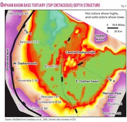
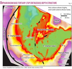
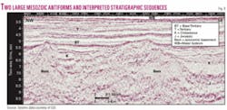
The basin was initially formed during the Late Triassic-Early Jurassic intracontinental rifting (Tethys rifting stage) as part of the network of rift basins extending from the Scotian shelf and slope to the Irish and North seas.3 4 Successive extensional tectonic episodes throughout the Late Jurassic to Paleocene have deformed the sedimentary section into a number of anticlinal and fault-bounded structures, some involving the basement and others within the sedimentary section itself (Fig. 5).
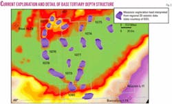
Being connected to proven petroleum systems of the Jeanne d’Arc and Flemish Pass basins and containing many large undrilled features within similar age rocks, the East Orphan basin is seen to have considerable petroleum potential (Fig. 6).
Recent seismic data, collected with longer streamer lengths and processed with modern migration algorithms, provides significantly improved imaging of the anticlines, rotated fault blocks, and basin floor fans that form the potential hydrocarbon traps and of the sedimentary fill within the half-grabens and intradepressions that is likely to contain the Late Jurassic oil prone source rocks.1 3 4 8
Additionally, the thick shale intervals mapped within the Late Cretaceous and Early Tertiary sections may generate gas, as witnessed in the Labrador Sea basins to the north.
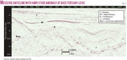
Several large leads with areas between 200 and 400 sq km were identified on the 2D speculative data with the potential to contain giant fields. Two of these large anticlines are illustrated in Figs. 7 and 8 (locations confidential).
The eight “first round” exploration licenses (ELs) awarded in December 2003 cover more than 5 million acres (Fig. 6). 3D seismic surveys, environmental assessment, and sea bottom hazard work will continue during the next few years. Several wells will likely be drilled in 2006-08.
A significant area of petroleum potential located within this basin and at the transition to the Flemish Pass basin remains to be licensed.
West Orphan basin
The West Orphan basin is an area of 60,000 sq km lying between the White Sail and Bonavista faults (Figs. 4 and 5). This area is a younger rift basin that has formed mainly during Cretaceous extensional stages (North Atlantic and Labrador rift stages) of intracontinental rifting and Atlantic Ocean opening.2-4
The Tertiary section is significantly thicker than in the East Orphan basin, ranging from 3,000 m to 5,000 m in thickness (Figs. 4 and 5). Below the base of Tertiary seismic marker, a thick Mesozoic section can be seen in the downthrown block of the basin-bounding Bonavista fault.1 4 8 Although seismic imaging below the base of Tertiary in this area is not as clear as it is to the east, it appears that the West Orphan basin contains thick Cretaceous subbasins between the NE-SW trending ridges.
Some sedimentary troughs may contain in excess of 7 km of Cretaceous sedimentary rocks. It is possible that Jurassic sediments may be present to some degree in several deep troughs in the West Orphan basin, but current seismic imaging does not allow a definitive conclusion to this effect.
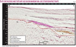
All the Orphan basin exploration wells are located in this basin, but they tested a condensed Cretaceous interval overlying and flanking the highest basement horsts.1 3 4 8 9 The seismic data show a significant number of potential hydrocarbon traps within Cretaceous sediments, including tilted fault blocks, drape closures over basement highs, and stratigraphic traps on the flanks of basement highs (Fig. 9).
Several Late Cretaceous and Early Tertiary seismic sequences have the characteristic aspect of marginal fans, but 3D mapping is necessary to verify their areal extent and shape and trapping potential.4 22 Some of these features are associated with amplitude anomalies.
Subject to any environmental or other restrictions that may be identified by regulatory authorities, the entire West Orphan basin is available for licensing.
Potential source rocks
Euxinic conditions that existed in the East Orphan basin during the Late Jurassic would have resulted in the deposition of high TOC oil prone source rock, similar to the Egret member in the Jeanne d’Arc basin to the south.
Similar conditions existed in many of the North Atlantic marginal basins during the Late Jurassic and resulted in the deposition of the source rocks for the oil found in Hibernia, Terra Nova, and White Rose fields in the Jeanne d’Arc basin (Egret member), Connemara oil field in the Porcupine basin and the Kinsale Head gas fields found in the Celtic Sea basin off Ireland,23 as well as the Kimmeridge clay that is the source rock for the North Sea oil fields.
Given our current understanding of the paleogeography of the Orphan basin and the prevalence of Late Jurassic source rocks in the North Atlantic marginal basins, it is very likely that good oil prone source rocks are present in the East Orphan basin.
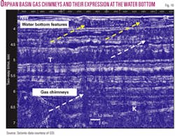
Direct seismic correlation of Jurassic markers to the Baccalieu I-78 well in the Flemish Pass and to several wells in the Jeanne d’Arc basin (e.g. Panther P-95) also indicate the extension of source rocks beds into the East Orphan basin.24 Additional evidence for the presence of source rocks throughout the Orphan basin includes a number of gas chimneys and amplitude anomalies seen on the new seismic data (Fig. 10).
As indicated by current seismic imaging it is most likely that Jurassic rocks were not deposited in the West Orphan basin. In this case a different source rock needs to be postulated to support a petroleum system in this area.
One possible candidate would be the equivalent of the Cretaceous Markland shale, which is the recognized source rock for the Labrador gas discoveries to the north or similar Albian organic-rich shales as those drilled by ODP Leg 210 site #1276 on the continental rise.4 8 15 24
Other possibilities would include early Tertiary shales that have been shown to have high organic content, but low hydrogen index in a number of wells in the basin. Geochemical analysis of the Early Tertiary shales penetrated by the West Orphan wells indicates that this section contains a high proportion (2-6%) of organic carbon.
The Tertiary source rocks are immature to marginally mature at the drilled locations but may become fully mature in the deeper parts of the basin. A burial depth greater than 3,000 m is required to begin generation of hydrocarbons from these shales, but given that the Tertiary section reaches a thickness of 4,000 m in much of the West Orphan basin, these source rocks would have reached maturity in large areas.
Potential for reservoir
High quality reservoir rocks within the Jurassic to Early Tertiary sequences have been encountered in the adjacent basins to the south.
The Jeanne d’Arc basin/Central Ridge area has more than 2 billion bbl of proven recoverable oil and 5.6 tcf of recoverable gas in these sequences.4 5 7 8 12 14 15 Flow rates from Cretaceous sands at Hibernia field have exceeded 50,000 b/d from a single zone, and development wells at Terra Nova field produce in excess of 40,000 b/d. Excellent Cretaceous reservoirs have been intersected in several Flemish Pass basin wells.6 7 22 Seismic correlations indicate that similar age reservoirs will exist in the Orphan basin in very large features.
Data from the Blue H-28 well and wells drilled in the West Orphan area,11 as well as DSDP site #111 drilled on the Orphan Knoll,10 indicate that the emergent blocks surrounding the Orphan basinal areas are partly composed of Paleozoic sandstones. These blocks would have provided an excellent provenance area for reservoir quality sandstones.
The porous sandstones described in the Early Cretaceous section of the Blue H-28 well with porosities up to 19%11 and the Late Cretaceous section of the Linnet E-63 well has confirmed the presence of reservoir quality sands.
Reservoir quality sands should also have been deposited during regressive episodes in the Early Tertiary, similar to the Paleocene reservoirs of the Jeanne d’Arc basin where they form a thick apron, and submarine fans described in the Paleocene-Oligocene section in the Porcupine basin.7 8 23
Exploration risk and potential
The past few years have seen year round drilling in the shallow waters (100 m) of the Jeanne d’Arc basin and in deepwater areas off Nova Scotia.
Two deepwater wells in the Flemish Pass basin (1,000-1,600 m of water) were drilled in the winter-spring of 2003 (Mizzen L-11 and Tuckamore B-27). Possible locations on recently licensed land in the East Orphan basin are in even deeper water (2,000-3,000 m).4 6 7 These will be costly wells spudded in a harsh environment, and only significant potential for large discoveries in a practically virgin basin makes drilling this basin’s prospects attractive to major operators.
Smee8 performed a preliminary resource assessment of some of the structural prospects and leads mapped using the GSI seismic grid in the Orphan basin.1 8 The analysis was unrisked and assumed the presence of reservoir and source rocks, that the source rock was mature, and that it had generated sufficient oil with proper migration timing to charge the mapped features.
Total areas of closure were estimated from Jurassic and Cretaceous time structural maps, and thickness of reservoir was estimated from seismic character and adjusted to values encountered in adjacent basins. This information was used to generate Monte Carlo probabilistic resource estimates based on ten field parameters. Of the 15 structures analyzed, four had a mean potential in excess of 1 billion bbl recoverable, five had a mean potential of 500 million to 1 billion bbl recoverable, with the rest ranging from 128 million to 470 million bbl recoverable.1 8
It is acknowledged that these very encouraging numbers are computed on the basis of preliminary 2D seismic mapping and that uncertainty remains in regard to source rock quality, distribution and maturity, and reservoir properties. More precise reserves estimates will be computed after interpretation of 3D seismic data and prestack seismic analyses.
Present exploration
Recently published or presented work indicates that several groups of companies had access to speculative surveys and legacy seismic grids in the basin, went through similar probabilistic evaluation processes, and have presented research showing large leads in the East Orphan basin.26
However, the record-setting bids by the winning consortium (Chevron-ExxonMobil-Imperial) ensured success in acquiring all eight parcels being offered in the East Orphan basin. Together with Shell Canada they own rights to explore an area totaling 8,300 sq miles.
Four exploration licenses (1073, 1075, 1076, and 1077) are operated by Chevron and the other four (1074, 1078, 1079, and 1080) by ExxonMobil (Fig. 6). An average block is more than 100 times larger than the standard Gulf of Mexico parcel.
Last year Chevron acquired 1,900 sq km of 3D seismic in ELs 1076 and 1077 delineating several large leads. The two operators plan two large 3D surveys totaling 8,000-10,000 sq km in 2005.
Starting last year a series of scientific ocean bottom surveys were conducted to address potential drilling hazards, and environmental and wellsite surveys will continue during 2005 in preparation for the start of drilling in 2006. A comprehensive environmental report is accessible from CNLOPB web site.27
Acknowledgments
Paul and Davey Einarsson, Sam Nader, Geophysical Service Inc. (GSI) for seismic data donation; John Hogg, Kevin Meyer, Garth Syhlonyk, Jim Wright, Ian Atkinson, Steve Kearsey, Department of Earth Sciences, Pan-Atlantic Petroleum Systems Consortium, Memorial University of Newfoundland, Husky Energy, GSC Atlantic, Leona Stead, Newfoundland and Labrador Department of Natural Resources, David Hawkins, CNLOPB, Landmark Graphics; NSERC and PRAC for grant support to M. Enachescu. ✦
References
1. Smee, G.W., Nader, S., Einarsson, P., Hached, R., and Enachescu, M.E., “Orphan Basin, offshore Newfoundland: New seismic data and hydrocarbon plays for a dormant frontier basin,” CSPG/CSEG Joint Convention, Calgary, June 2003.
2. Enachescu, M., Hogg, J., and Meyer, K., “East Orphan Basin, offshore Newfoundland and Labrador: A deepwater super extended rift with potential petroleum system,” expanded abs., CSPG annual convention, 2004, 4 p.
3. Enachescu, M.E., Meyer, K.E., and Hogg, J.R., “East Orphan Basin: Structural Setting and Evolution with Seismic and Potential Fields Arguments,” expanded abs., CSEG annual meeting, 2004, 4 p.
4. Enachescu, M., Kearsey, S., Hogg J, Einarsson, P., Nader, S., and J. Smee, “Orphan Basin, Offshore Newfoundland, Canada: Structural and Tectonic framework, Petroleum System and Exploration Potential,” expanded abs., SEG annual meeting, Denver, 2004.
5. Enachescu, M.E., “Atlantic Canada: An emerging energy powerhouse,” Atlantic Business Magazine, Vol. 15, No. 2, 2004, pp. 12-19.
6. Enachescu, M., and Fagan, P., “Newfoundland’s Grand Banks presents untested oil and gas potential in eastern North America,” OGJ, Feb. 14, 2005, p. 32.
7. Enachescu, M., and Fagan, P., “Newfoundland and Labrador Call for Bids NF04-01, Government of Newfoundland and Labrador, Department of Natural Resources, 35 p., 20 figs.; (also available at http://www.gov.nl.ca/mines&en/oil/call_for_bids_nf04_01.stm).
8. Smee, J., “Hydrocarbon Potential of Parcels 1-12, CNLOPB Call for Bids NL 03-1, Orphan Basin Offshore Newfoundland,” prepared for Department of Mine and Energy, Government of Newfoundland and Labrador by G&G Exploration Consulting Ltd., 2003, and available at (http://www.gov.nl.ca/mines&en/oil/callforbids/).
9. Canada-Newfoundland and Labrador Offshore Petroleum Board, Schedule of wells, Newfoundland and Labrador offshore area, February 2003.
10. Van Hinte, J.E., and Ruffman, A., with van den Boogaard, M., Jansonius, J., van Kempen, T.M.G., Melchin, M.J., and Miller, T.H., “Palaeozoic fossils from Orphan Knoll, NW Atlantic Ocean,” Scripta Geologica 109, 1995, pp. 1-63.
11. Koning, T., Campbell, R.H., Hibbs, D.C., and Leohhardt, G.W., “An exploration case study of a world record deepwater wildcat well,” proceedings-Offshore Technology Conference, Vol. 20, No. 1, 1988, pp. 395-406.
12. Enachescu, M.E., “Tectonic and structural framework of the Northeast Newfoundland continental margin,” in Beaumont, C., and Tankard, A.J., eds., “Sedimentary Basins and Basin-Forming Mechanisms,” CSPG Memoir 12, 1987, pp. 117-146.
13. Enachescu, M.E., “Extended basement beneath the intracratonic rifted basins of the Grand Banks of Newfoundland,” CJEG, Vol. 24, No. 1, 1988, pp. 48-65.
14. Tankard, A.J., and Welsink, H.J., “Mesozoic extension and styles of basin formation in Atlantic Canada,” in Tankard, A.J., and Balkwill, H.R., eds., “Extensional Tectonics and Stratigraphy of the North Atlantic Margins,” AAPG Memoir 46, 1989, pp. 175-196.
15. McAlpine, K.D., “Mesozoic stratigraphy, sedimentary evolution, and petroleum potential of the Jeanne d’Arc Basin, Grand Banks of Newfoundland,” GSC Paper 89-17, 1990, 50 p.
16. Grant, A.C., and McAlpine, K.D., “The continental margin around Newfoundland,” in Keen, M.J., and Williams, G.L., eds., “Geology of the Continental Margin of Eastern Canada,” GSC, Geology of Canada 2, 1990, pp. 239-292.
17. Srivastava, S.P., and Verhof, J., “Evolution of Mesozoic sedimentary basins around the North Central Atlantic: a preliminary plate kinematic solution,” in Parnell. J., ed., “Basins on the Atlantic Seaboard: Petroleum Geology, Sedimentology, and Basin Evolution,” Geological Society Spec. Pub. No. 62, 1992, pp. 397-420.
18. Keen, C.E., and Dehler, S.A., “Stretching and subsidence: rifting of conjugate margins in the North Atlantic region,” Tectonics, Vol. 12, No. 5, 1993, pp. 1,209-29.
19. Edwards, A., and McAlpine, K.D., Geological Survey of Canada, East Coast basin atlas series, Grand Banks of Newfoundland, 1999.
20. Sinclair, I.K., Shannon P.M., Williams, B.P.J., Harker, S.D., and Moore J.G., “Tectonic control on the sedimentary evolution of three North Atlantic borderland Mesozoic basins,” Basin Research 6, 1994, pp. 193-217.
21. Reid, I.D., and Jackson, H.R., “Crustal structure beneath Orphan Basin and implication for nonvolcanic continental rifting,” JGR, Vol. 106, No. 6, 2001, pp. 10,923-940.
22. Hogg, J.R., and Enachescu, M.E., “Deepwater Mesozoic and Tertiary Depositional Systems Offshore Nova Scotia and Newfoundland, Atlantic Canada,” Stavanger Conference, 2004.
23. Shannon, P.M., Haughton, P.D.W., and Corcoran, D., eds., “Petroleum Exploration of Ireland’s Offshore,” GSL Special Publication, 2001.
26. Enachescu, M., Kearsey, S., Hardy, V., Sibuet, J.-C., Srivastava, S., Hogg, J., Smee, J., and Fagan, P., “New Insights in the Tectonic and Structural Evolution and Petroleum Systems of the Orphan Basin, Atlantic Canada,” extended abs., AAPG Conference, Calgary, 2005, 8 p.
27. Tucholke, B.E., Sibuet, J.-C., Klaus, A., and Leg 210 party crew, Proc. ODP, Init. Repts., 210 [CD-ROM], 2004, available from: Ocean Drilling Program, Texas A&M University, College Station TX 77845-9547, USA or (http://www-odp.tamu.edu/publications/210_IR/210ir.htm).
28. Skogseid, J., Barnwell, A., Aarseth, E.S., Alsgaard, P.Co., Briseid, H.C., and Zwach, C., “Orphan basin: Multiple failed rifting during early opening of the north Atlantic,” Eos. Trans., AGU, Vol. 85, 2004 (17, Joint Assembly Suppl., Abstract T41B-03).
29. LGL Ltd., “Orphan Basin Strategic Environmental Assessment,” prepared for CNLOPB, 2003 (http://www.cnopb.nfnet.com/newsr/2003nr/landsale/ob_ea.pdf).
More comprehensive references available (http://www.gov.nl.ca/mines&en/oil/).
