Stunning Utah oil, gas discovery focuses spotlight on Hingeline

Central Utah, once the orphan child of hydrocarbon exploration, may soon have many fathers.
A recent new field discovery and first offset operated by Wolverine Gas & Oil Co., private Grand Rapids, Mich., independent, on the Central Utah Overthrust appears to have exceeded 200,000 bbl of oil since May 2004 from the Jurassic Navajo sandstone and Twin Creek limestone at 6,000-7,000 ft.
The two wells are now capable of yielding as much as 4,400 b/d of oil from a very large hanging wall, thrusted anticlinal structure defined by 2D seismic. The structure eventually could produce well over 500 million bbl of oil. Deeper potential pay horizons are certainly present but have not yet been drilled.
Wolverine was directionally drilling the first of seven development wells in late December to better define the oil field limits.
No name has been designated for this new field as far as we know, so we use "Kings Meadow Ranches" as a field name in this article.
Best since Pineview?
The Wolverine discovery is one of many fine prospects drilled as major discoveries after being shown at the North American Prospect Expo held annually in Houston. This, however, is a prospect that almost no one would buy.
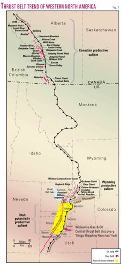
One story is that Sidney J. Jansma Jr., president of Wolverine, raised the drilling funds from outside the oil industry. His bold vision has caused a 150-mile segment of the Central Utah thrust belt to become the focus of what will undoubtedly be a fierce and rewarding firestorm of leasing, drilling, and discovery not seen since Pineview oil and gas field was brought into production in 1975 (Fig. 1).
The Pineview discovery set off a 5-year exploration melee that resulted in the drilling of 175 wildcats and the discovery of 11 new fields, mostly in Wyoming. Two of these discovered fields are giant Anschutz Ranch East and giant Whitney Canyon-Carter Creek.
The former Amoco Production Co., with its control of the Union Pacific acreage right-of-way, essentially controlled the destiny of the Pineview era exploration effort in Wyoming. The central Utah play, on the other hand, is pretty much open to independents since most major oil companies no longer explore in the Rocky Mountains.
If recent competitive federal and state lease sales are an indication of intent, then Wolverine Gas & Oil, Pioneer Oil & Gas, International Petroleum LLC, Armstrong Petroleum, PetroHunt, and Craig Settle are but a few of the independents presently leading the charge. And the potential could easily exceed what was discovered in the sister play to the north.
Wolverine has completed a 116-mile seismic program to complement older Chevron data (the discovery was a farmout from Chevron Corp.). These data will assist Wolverine in the development of a 65,000-acre federal unit and other, nearby prospects in the area that include at least four additional structures in Wolverine's federal unit similar to the discovery.
At least one seismic group shoot is being formulated to start by the summer of 2005. In addition, we anticipate seeing six or more wells drilled along the Central Utah thrust belt by mid-2005.
Competitive oil and gas lease bids have risen to as much as $700/acre in some high priority areas. Large lease blocks are being offered at as much as $300/acre, and most have drilling requirements.
Lease price hikes can be expected as word spreads about the quality of the production. Wolverine is trying hard to keep production statistics confidential for good reason. In the Pineview era, lease prices reached thousands of dollars per acre in high priority areas, and those were 1970 dollars.
Wolverine discovery
The Wolverine discovery well, 17-1 Kings Meadow Ranches, in SE NW 17-23s-1w, Sevier County, Utah, was spudded on Dec. 9, 2003, and completed May 3, 2004, as a tight hole after reaching an estimated TD of 10,750 ft.
It has produced an estimated 144,000 bbl of oil. It initially produced 800 b/d of oil from a perforated interval of only about 12 ft.
A rework program with additional perforations in early November 2004 was followed with the installation of a submersible pump. Scout reports indicate the well is producing over 2,000 b/d of oil from the Navajo.
All produced oil is being trucked to ChevronTexaco's 45,000 b/d refinery in Salt Lake City from a single, flowline-fed storage facility at the 17-1 well pad. Fully developed, Wolverine's field might have upwards of 70 wells.
Field development
Wolverine spudded the second well on July 2, 2004. The KMR 17-2 well is in SE SW 17-23s-1w, Sevier County, 1/2 mile south of the KMR 17-1 well.
The second well was also drilled as a tight hole, but several interesting tidbits of scout data have caught our attention. On July 23, 2004, while drilling at 5,807 ft with 8.6 ppg mud in the Twin Creek, oil was observed on the mud pit, and then the well attempted to blow out. Mudloggers noted 4,000 units of gas.
A core revealed a tight but well fractured limestone with good oil saturation. Wolverine registered the Aug. 19 completion with the state as a gas well.
A submersible pump was installed in casing in November after Wolverine had perforated a small interval of the Navajo at 6,400(?) ft. On Nov. 25, this well was reported to be capable of producing as much as 2,400 b/d of oil. It was shut-in for mechanical work at this writing in early January.
Oil characteristics
Oil in the Wolverine wells is Paleozoic sourced and is derived from marlstone, not shale. It is low in sulfur content (0.57%) and of good quality (40° gravity).
Two marine biomarkers have been observed in the oil. They have been identified as Permian and Mississippian with a possible overmature condensate mix that may have originated from organic rich Lower Cretaceous sediments below the Gunnison thrust. Structures farther north of Wolverine's discovery will have an even better chance of a Cretaceous oil source in addition to the primary Paleozoic source already noted.
World class reservoir
The Navajo formation is comprised mostly of very clean, eolian, quartzose sandstone.
It is more than 1,200 ft thick in the discovery well. At least the top 500 ft are filled with oil. A secondary reservoir, Twin Creek, rests atop the Navajo. It is apparently similar to production in the thrust belt's Wyoming salient, where it has little primary porosity but is often fractured.
Seismic structure
Several years ago, Wolverine distributed at the prospect expo copies of its seismic structure map that defined the drill site and structural configuration of what would become Kings Meadow Ranches field.
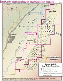
This structure is ten miles long and four miles wide as mapped on the Navajo No. 2 sandstone marker. We have redrawn and somewhat modified this anticline on a topographic base to see how topography and deep structure interact (Fig. 2).
Wolverine has secured permits to drill as many as seven directional wells from the two presently producing pads as development wells to confirm the size of the structure at the first producing Navajo sandstone level we call Navajo No. 1. The first of these wells was drilling in late December. Some of these proposed offsets are fairly bold stepouts of over 1 mile.
Duplex structure
Two Navajo sandstones are superposed on the Gunnison hanging wall folded structure (Fig. 3).
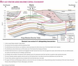
Navajo No. 1 is the producing zone now being developed by Wolverine. Navajo No. 2 (2,000 ft deeper) had oil shows in the 17-1 well. The 17-2 well was not drilled deep enough to penetrate Navajo No. 2. Both Navajo sandstones may be productive on the higher part of the structure to the south (Fig. 2). Since the south leg of the anticline has 600 ft more structural closure than the discovery, Navajo No. 1 in the south leg may have 1,100 ft of pay and up to twice the recoverable oil per well as the discovery!
Reserves outlook
Only an educated guess can be made as to reserves due to the operator's confidentiality.
A common recovery factor for the Jurassic Nugget sandstone (equivalent to central Utah's Navajo) in Wyoming is 200 bbl/acre-ft.
If Wolverine drills at 160-acre spacing (like its permitted locations seem to indicate), and the scout information correctly identifies 400 net ft of pay, then we can give this a very hypothetical reserve estimate: 200 bbl/acre-ft times 400 net ft of pay times 160 acres equals 12.8 million bbl/well recoverable.
If the production rate really is 2,000 b/d/well, then with no decline each well will have a life of 17.5 years. Since a decline rate is imminent, these wells will be around for quite awhile.
After extrapolating 70 potential well sites on Wolverine's own seismic structure map, we estimate that Kings Meadow Ranches field will have 896 million bbl recoverable from the Navajo No. 1 alone. More production may come from more pay in Navajo No. 1 on the south leg, from Navajo No. 2 on the south leg, and from Twin Creek on the entire structure. Deeper production, if found, would be additional (remember that the oil is sourced from the deeper, older Paleozoic rocks.)
As an aside, estimated ultimate recovery at Anschutz Ranch East field is at least 15 million boe/well from a retrograde condensate reservoir in the Nugget.
Thrust belt geology
We somewhat arbitrarily divide the North American thrust belt into six regions or salients, three of which are productive (Fig. 1).
Production was first discovered in the northern or Canadian salient at an oil seep in Turner Valley, southwest of Calgary, in 1924.
The central portion we call the Wyoming salient, discovered at Pineview, Utah, and mostly in Wyoming, is bounded by the Uinta Mountains to the south and the Snake River Plain to the north.
The third productive salient is in central Utah, south of the Uinta Mountains, extending south 150 miles almost to Beaver, Utah (35 miles south of Richfield). This Central Utah thrust and fold belt was penetrated by 115 exploration wells prior to the discovery this year of Kings Meadow Ranches field.
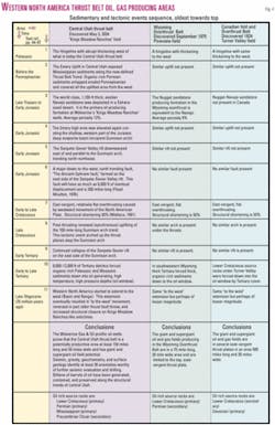
The basic geology of the central Utah play has similarities and definite differences when compared to productive thrust trends of the Canadian and Wyoming salients. We have elected to compare the basic geology of these three salients on a spreadsheet (Fig. 4). Ultimately, the death knell to Central Utah until now was a perceived absence of source rocks.
1. The Hingeline. The Central Utah thrust belt (Utah salient) is located just east of the abrupt, western thickening of Paleozoic rocks (Fig. 5). This thickening is more abrupt than at the Canadian or Wyoming salients.
Thick, organic-rich Paleozoic rocks are critical as both source and potential reservoir rocks in the Utah salient: The Wolverine discovery produces oil typed as being Paleozoic (Mississippian to Permian age).
Since this oil has migrated from west to east to fill Kings Meadow Ranches field, all contemporaneous, intervening structural closures must have been filled with hydrocarbons prior to Wolverine's anticline.
Do these undrilled structures contain oil to the west where the best Central Utah thrust belt oil and gas shows were noted prior to Wolverine's success? We have geochemical data that indicate "yes" and point to even more potentially productive structures in the Paxton and Pavant Thrust trends than in the easternmost Gunnison Thrust trend.
In addition to Jurassic reservoirs now productive in central Utah, Paleozoic carbonates may also be productive from porosity enhanced by karsting as well as fracturing, in some ways similar to Whitney Canyon-Carter Creek field Paleozoic production sourced by Cretaceous shales1 in Wyoming and Paleozoic sourced Mississippian and Devonian reservoirs in Canada.
2. Emery uplift. In central Utah, a large, east-west trending uplift began prior to Pennsylvanian and exposed rocks at least as old as Mississippian carbonates in an area now occupied in part by the central Utah thrusts (Fig. 5). This uplift is defined by isopach (thickness) mapping the Mississippian to Permian interval. Pennsylvanian carbonates were either eroded, or not deposited, as well.
This type of uplift resulted in porosity enhancement in exposed rocks. Karsting may provide even better oil production in Paleozoic rocks than the great rates in Wolverine's Jurassic-age reservoirs. Organic-rich Permian sediments onlapped and covered all the uplifted area from the west.
Permian oil is the source of several significant oil fields and tar deposits in central Utah. These include Upper Valley field in the Kaiparowitz basin and the Tar Sand Triangle. In that triangle 60 miles east of the Wolverine discovery in the Permian White Rim sandstone, up to 16 billion bbl of oil has migrated, then been exposed on the surface as a tar sand deposit.
3. Navajo sandstone. The world class, 1,100-ft thick, Early Jurassic age eolian Navajo sandstone was deposited in a Sahara-sized desert that ranged from Nevada to Nebraska and Arizona to Montana. This same sandstone is called the Nugget in the Wyoming salient, where it is the primary productive horizon.
But there are differences. In Wyoming it can also be over 1,000 ft thick, but there it is much tighter and often needs natural fracturing in anticlinal folds to enhance hydrocarbon deliverability; average porosity is commonly 9%. Near Wolverine's discovery, Chevron drilled and cored the Navajo sandstone where it displayed better reservoir qualities in thicker zones with better porosity, averaging 12%.
4. Emery uplift rejuvenated. In early Jurassic, the Emery high was elevated again forming the shallow, western part of the Jurassic deep evaporite basin wherein thick deposits of gypsum, salts, silts, and shales were deposited as the Arapien and Carmel formations. These evaporates will later play a significant role in post-thrusting tectonics not displayed in the Wyoming salient.
The renewed Emery uplift transformed into the more northerly trending, incipient Gunnison arch. Synchronous highs like the Emery uplift-Gunnison arch are known to contain vast amounts of oil. A few examples are giant Elk Hills, Yates, and Lost Soldier fields.2 3
We are not saying these California, Texas, and Wyoming fields are in thrust regimes but that prior to thrusting fields of these magnitudes may have already been present only to be modified by more recent tectonics. Pre-thrusting oil migration in this general trend has been suggested by Loucks,4 Schelling and Wavrek,5 and Stone.6
5. Sanpete-Sevier Valley rift. A contemporaneous downwarping east of and parallel to the incipient Gunnison arch accentuated Jurassic evaporite deposition. No similar feature was present in Canada or Wyoming.
6. Ancient Ephraim fault. Also in early Jurassic a major down-to-the-west, north trending fault developed on the east side of the Sanpete-Sevier Valley rift and was accentuated by the Sanpete-Sevier Valley rift. This fault is 200 miles long and has throw of as much as 6,000 ft. Moulton recognized the importance of this fault and named it "The Ancient Ephraim fault" in 1976.7
7. Overthrusting. East-vergent, relatively flat overthrusts initiated in western Utah in early Cretaceous and continued to central Utah by earliest Paleocene. Westward movement of the North American Plate caused a structural shortening of 50%, similar to Canadian and Wyoming salients.8
In Utah four major, unique thrusting sheets are oldest on the west and include the Canyon Range thrust, the Pavant thrust, the Paxton thrust, and the youngest, and easternmost Gunnison thrust (containing Kings Meadow Ranches field).9
In Canada, several similar thrusts contain economic hydrocarbons. However, in Wyoming only the eastern Absaroka thrust is economic. Other thrusted anticlines are dry west of the Absaroka thrust because oil must migrate to them from the east to the west sourced by mature Cretaceous shales below the thrust plane.
On the other hand, west to east migration of oil does not happen in Wyoming. Fortunately, it does happen in the Canadian and Utah salients. For this reason the Utah salient may be productive from several separate thrust fronts like Canada and unlike Wyoming.
In an effort to evaluate this possibility, we acquired a proprietary satellite geochemical evaluation of the entire central Utah trend and looked for geochem signatures similar to the Wolverine discovery. Each of the four major thrust trends exhibits Kings Meadow Ranches-like geochemical signatures at structural culminations identified from gravity with the Paxton and Pavant thrusted trends exhibiting more quality anomalies than the other trends.
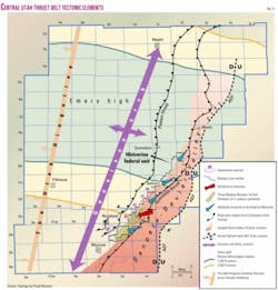
We include the locations of several of the geochemical anomalies associated with the Kings Meadow Ranches anticline and related structures on our tectonic elements map (Fig. 5). Note the position of anomalies 20 through 23 at the western edge of thick evaporates in the Sanpete-Sevier Valley rift. We suspect these anomalies are from hydrocarbon microseepage deflected west, traveling under the allochthonous salt and shale mass.
8. Gunnison arch continues. As thrusting wound down at the end of the Cretaceous, uplift at the Gunnison arch intensified. This hundred mile long north-northeast trending tectonic event (Fig. 5) arched up the thrust planes and continued through at least the early part of the Paleocene.
9. Sanpete-Sevier rift continues. Continued sagging above the Sanpete-Sevier rift accentuated the rift between the Gunnison arch and Ancient Ephraim fault during Tertiary and even Quaternary time.
After thrusting, thick salts within the rift have moved up section (west) at a 45° angle along an 80-mile trend that essentially follows the Gunnison thrust (see cross section, Fig. 3). This lateral salt movement is an allochthonous, evaporite mass that is sometimes defined as a subsurface salt glacier.
Gravity data clearly show an abrupt salt termination where it is eroded on the west. On the east, there appears to be a gradual, volumetric decrease.
10. Oil window. During the early to late Tertiary, the oil window was achieved in central Utah in both Paleozoic source rocks to the west and Cretaceous source rocks to the east because of the deposition of 8,000-12,000 ft of overlying Tertiary detritus.
These source rocks were forced deep enough to reach temperatures and pressures sufficient to generate oil and gas. This also happened in Canada, but in the Wyoming salient it appears that only Cretaceous shales yielded hydrocarbons only from under the Fossil Basin Tertiary deposits.
11. Basin and Range. Around 25 million years ago central and western Utah initiated extension. This "to the west" movement probably took place on the older thrust planes and may have actually increased east dip and, hence, the structural closure of the Kings Meadow Ranches-like anticlines. This "to the west" extension also caused the older thrusts planes to arch up under the Kings Meadow Ranches-type structures (Fig. 3).
Geologic conclusions
A giant oil field appears to have been found in the Central Utah thrust belt below Jurassic salt.
The geologic conditions for the trapping of hydrocarbons is more favorable in central Utah than in Wyoming. Although the thrusting is similar in age and magnitude, oil in the Central Utah thrust belt has migrated from both the west and the east, thereby significantly increasing the possibility of oil in all thrusted structural trends, not just the eastern Absaroka thrust as in the Wyoming salient.
Production in central Utah may be more like the Canadian thrust belt, with the exception that Utah's fields will contain more oil than gas and be lower in sulfur content while Canada's reserves are high sulfur and more gas prone.
Early exploration techniques
Seismic data will be definitive for the locations of the many wells we know will soon be drilled.
However, older seismic data in the Central Utah thrust belt is spotty. It is fair in some areas but poor in others. Data from old wells, gravity and magnetic data, surface geology, and geochemistry are all helpful until new vintage seismic takes over.
One exploration tool we have found useful is a satellite technique of measuring relative amounts of kaolinite in surface rocks. Microseepage of hydrocarbons creates a reducing environment, either stabilizing the kaolinite or altering other clay minerals to form kaolinite.10
A geochemical anomaly, caused by kaolinite abundance, is present at the Wolverine discovery well and is repeated over and over along the structural trends caused by the various oil trapping thrust fault structures over an area at least 150 miles long and 40 miles wide in the Central Utah thrust belt trend.
At least 30 of these geochemical anomalies appear to be located on or adjacent to gravity-defined structural culminations and look very much like the gravity residual anomaly and geochemical anomaly we mapped at Wolverine's discovery.
Drilling activity
Wolverine could have three to five rigs active in the area during the summer of 2005.
We suspect it will not only drill the other four structural closures within its 65,000-acre unit but may even test other prospects outside the unit.
Lion Oil Co., a private Denver independent, has shown interest to drill a Navajo sandstone well in the northeastern part of 13s-1e, in the foothill area southeast of Nephi, Utah. A significant residual gravity anomaly indicates this to be a large, northerly trending anticline. We also note several geochemical anomalies along this same structural trend. This area is 60 miles north of Wolverine's discovery (Fig. 5).
Summary
A third major oil producing segment of the western North American Overthrust Belt is now defined in central Utah. Geologic comparison to the 75 mile productive trend in Wyoming and the 960+-mile productive trend in Canada indicates the Utah salient should:
1. Be much larger than the Wyo- ming thrust belt trend.
2. Contain significantly more recoverable oil and gas reserves than have been discovered in Wyoming.
3. Exhibit the striking similarities to the Canadian thrust belt of multiple, productive thrust trends and Paleozoic hydrocarbons being sourced from the western hingeline area. F
References
1. Sieverding, J.L., and Royce, F., Jr., "Whitney Canyon-Carter Creek field: Gas production from carbonate reservoirs in a thrust-belt setting, Western Wyoming, USA," abs., AAPG Bull., Vol. 75, No. 3, 1991, p. 672.
2. Scholten, R., "Synchronous Highs: Preferential Habitat of Oil," AAPG Bull., Vol. 43, No. 8, 1959.
3. Reynolds, M.R., "Influence of Recurrent Laramide Strucutral Growth on Sedimentation and Petroleum Accumulation, Lost Soldier Area, Wyoming," AAPG Bull., Vol. 60, No. 1, 1976.
4. Loucks, G.G., 1975, "The search for Pineview Field, Summit County, Utah," in "Symposium on deep drilling frontiers of the central Rocky Mountains," RMAG, 1975, pp. 255-264.
5. Schelling, D.D., and Wavrek, D.A., "Structural Geology and Petroleum Systems of the Northwestern Wind River Basin, Wyoming," abs. AAPG Bull., Vol. 85, No. 13, 2001 (supplement).
6. Stone, D.S., "Theory of Paleozoic Oil and Gas Accumulation in the Big Horn Basin, Wyoming," AAPG Bull., Vol. 51, No. 10, 1967, pp. 2,056-2,114.
7. Moulton, F.C., "Lower Mesozoic and Upper Paleozoic Petroleum Potential of the Hingeline Area, Central Utah," in RMAG Guidebook, "Symposium on Geology on the Cordilleran Hingeline," 1976.
8. Wallace, R.E., ed., "The San Andreas Fault System, California," USGS Professional Paper 1515, 1991.
9. Hintze, L.F., and Davis, F.D., "Geology of Millard County, Utah," Bull. 133, Utah Geologic Survey, 2003.
10. Schumacher, D., "Hydrocarbon Induced Alteration of Soils and Sediments," in Schumacher, D., and Abrams, M.A., eds., "Hydrocarbon migration and its near-surface expression," AAPG Memoir 66, 1996, pp. 71-89.
Bibliography
Powers, R.B., "Oil and Gas Potential of Wyoming-Utah-Idaho Overthrust Belt—Relation to Canadian Foothills Province Analog," abs. AAPG Bull., Vol. 69, 1980, p. 767.
Rosenfeld, J.K., et al., "Oil-to-Source Correlation—Pineview Field, Overthrust Belt, Utah," abs. AAPG Bull., Vol. 64, 1980, p. 776.
The authors

Floyd Moulton is a consulting geologist in Salt Lake City. He spent 26 years with Phillips Petroleum Co. including 8 as area manager for the Overthrust of western North America. He worked 4 years with Anschutz Corp. in the drilling of Anschutz Ranch and Anschutz Ranch East fields in Wyoming and Utah. He has worked 35 years to unravel the geologic complexities of the Central Utah thrust belt, including the last 21 as a consultant. He has BS and MS degrees in geology from Brigham Young University.

Michael L. Pinnell ([email protected]) is exploration manger for Pioneer Oil & Gas, where he has been employed for 15 years. He first worked for Exxon Co. USA in Texas but was drawn to the Rockies in 1976. His work has concentrated mostly in Wyoming, Colorado, and Utah. Interest in the Central Utah thrust belt began with a thesis mapping project in 1969. His specialty is innovative geologic concept illustrations. He has BS and MS degrees in geology from BYU.