Deep-seated lacustrine source rock may occur in Gongola basin, Nigeria
Standard organic geochemical analyses were carried out to assess the source-rock potential of selected samples from the Nasara-1 exploratory well drilled through an entirely Cretaceous succession in the Gongola basin of Nigeria’s Upper Benue Trough.
Total organic carbon (TOC) content and hydrogen indices (HIs) were found generally to be very low. However, in the depth interval 4,710-70 ft, TOC values of 52.1-55.2 wt % were recorded (may be coal). HIs were between 564 and 589 mg HC/g TOC, and Tmax was 423-428° C. Biomarker data indicate a dominance of low molecular weight n-alkanes (C15-C25), pristane/phytane ratios of 0.8-1.3, and very high contents of C28 regular steranes.
These attributes indicate that some oils generated from a probably deeper seated or laterally located (yet to be identified) lacustrine source rock must have migrated and adsorbed into the rock facies represented by this interval. Deep-seated Cretaceous lacustrine source rocks are the major sources of oil in adjacent Doba (Chad) and Muglad (Sudan) basins, which are genetically and structurally related to the Nigerian Benue Trough.
Introduction
The Gongola basin is the north-south trending arm, which together with east-west trending arm otherwise termed the Yola basin, constitutes the Upper Benue Trough in Nigeria.
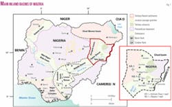
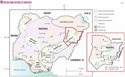
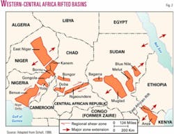
The Upper Benue Trough along with the Middle Benue Trough, the Lower Benue Trough, the Anambra basin, the Chad basin, and the Sokoto basin constitute a Nigerian set of inland basins (Fig. 1). These inland basins form a portion of another series of Cretaceous and later rift basins in Central and West Africa whose origin is related to the opening of the South Atlantic1 (Fig. 2).
Commercial volumes of hydrocarbons have been discovered in Chad and Sudan in this rift trend. In southwestern Chad, development of the Doba discovery with estimated reserves of about 1 billion bbl by an ExxonMobil Corp. affiliate has led to the construction of a 1,070-km pipeline through Cameroon to the Atlantic Coast. In Sudan, giant fields such as Unity 1 and 2, Kaikang, and Heglig have been discovered in the Muglad basin.2 3
Lacustrine shales are the major sources of the oils in the Doba and Muglad basins. In Niger, oil and gas shows correlated to lacrustrine sources have also been encountered in Mesozoic-Cenozoic sequences in the East Niger graben, which is structurally related to the Benue-Chad-Sudan-Libyan rift complexes.4
Exploration success in the Muglad basin of Sudan together with the commercial discoveries in neighboring Chad encouraged some oil companies operating in Nigeria to acquire exploration leases in Nigeria’s inland basins, specifically in the Gongola basin of the Upper Benue Trough in 1992. Before this, Nigerian National Petroleum Corp. through its frontier exploration services arm (NAPIMS) had drilled some 23 wells in the Nigerian sector of the Chad basin, of which only two wells encountered subcommercial volumes of gas.
The first well in the Benue Trough region, Kolmani River-1, drilled by Shell Nigeria Exploration and Production Co. to a depth of about 3,000 m in 1999, encountered 33 bscf of gas and little oil. Two other wells, Kuzari-1 and Nasara-1, drilled by Elf Petroleum Nigeria Ltd. (Total) in 1999 to a depth of 1,666 m and Chevron Nigeria Ltd. (Chevron) in 2000 to a depth of about 1,700 m, were dry. Exploration efforts in Nigeria’s inland basins have so far resulted in little success.
Chevron Nigeria made available samples from Nasara-1 for this study. The study aimed at evaluating the petroleum source rock characteristics of the rock successions penetrated and to ascertain the possibility of the occurrence of lacustrine petroleum source rocks as obtained in the contiguous Muglad and Doba basins.
Geologic setting
The Gongola basin is located in the northeast part of the Benue Trough, which is a NNE-SSW trending rift basin 800 km long and 150 km wide that contains up to 6,000 m of Cretaceous-Tertiary sedimentary rocks (Fig. 1).
The section that predates a mid-Santonian compressional phase has been folded, faulted, and locally uplifted, resulting in over 100 anticlines and synclines.1 Following mid-Santonian tectonism and magmatism, the depositional axis in the Benue Trough was displaced westwards, resulting in subsidence of the Anambra basin. This basin is part of the Lower Benue Trough and contains post-deformational deposits of Campanian-Maastrichtian to Eocene ages.5
The Gongola basin together with the Yola basin make up the Upper Benue Trough. Some authors recognize a third basin, the Lau-Gombe basin.6 7
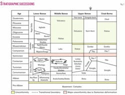
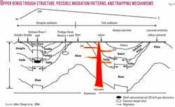
In the Gongola and Yola basins, the Albian Bima sandstone rests unconformably on Precambrian basement (Fig. 3). The formation was deposited under continental conditions (fluvial, deltaic, lacustrine) and is made up of coarse- to medium-grained sandstones intercalated with carbonaceous clays, shales, and mudstones.
Carter et al.8 subdivided the Bima sandstone into lower, middle, and upper units. The Middle Bima is reported to be generally shaly with some limestone intercalations and assumed to have been deposited under a more aqueous anoxic condition (lacustrine, brief marine).
The Yolde formation rests conformably on the Bima sandstone. This formation of Cenomanian age represents the beginning of a marine incursion into this part of the Benue Trough and was deposited in a transitional-coastal marine environment. It is composed of sandstones, limestones, shales, clays, and claystones.
In the Gongola basin, the laterally-equivalent Gongila and Pindiga formations and the possibly younger Fika shale rest conformably on the Yolde formation. These formations represent a fully marine incursion into the Upper Benue Trough during Turonian-Santonian times.
Lithologically, these formations are characterized by dark or black carbonaceous limestones and shales intercalated with pale limestones, shales, and minor sandstones. The Fika shale is made up of bluish-green carbonaceous, sometimes pale-colored gypsiferous, highly fissile shales with occasional limestones in places.
In the Yola basin, the Dukul, Jessu, and Sekuliye formations, the Numanha shale, and the Lamja sandstone are the Turonian-Santonian equivalents of the Gongila and Pindiga formations. The Turonian-Santonian deposits in the Yola basin are lithologically and paleoenvironmentally similar to those in the Gongola “arm,” with the exception of the Lamja sandstone which consists of marine sandstones with intercalated coal deposits.
The Santonian was a period of folding and deformation throughout the Benue Trough. Post-folding sediments are represented by the continental Gombe sandstone of Maastrichtian age and the Kerri-Kerri formation of Tertiary age. The Gombe sandstone is lithologically similar to the Bima sandstone but also contains coal, lignite, and coaly shale intercalations. The Kerri-Kerri formation is made up of whitish grey sandstones, siltstones, and claystones with the claystones dominating the lithology in most places.
The Nasara-1 well, located in Futuk village (near Pindiga), penetrated the Pindiga and Yolde formations and probably also the very top of the Bima sandstone (Fig. 4).
Methodology
A total of 63 ditch cutting samples of shale and coaly lithologies were collected from the Nasara-1 well at 30 ft intervals, except where samples were not available or were too sandy to contain an appreciable quantity of organic matter.
All samples were pulverized and analyzed for TOC by means of a LECO-CS analyzer and pyrolyzed in a Vinci Rock-Eval 6 instrument. Samples for TOC determination were treated with hydrochloric acid to remove carbonate-bonded carbon before combustion in the LECO-CS analyzer.
Selected samples were solvent extracted by means of an accelerated solvent extractor using isohexane and acetone in a 9:1 ratio. Asphaltenes in the extracts were precipitated by addition of petroleum benzene. The remaining maltenes were fractionated into saturated (aliphatic) and aromatic hydrocarbons (HCs) and heteroatomic compounds (NSO).
The saturated HC fractions were analyzed by gas chromatography by means of a Hewlett Packard 5890 gas chromatograph fitted with a 30-m HP5-MS column and flame ionization detector (FID). Additionally, the saturated HC fractions were analyzed by selected ion monitoring (SIM) for m/z 71, m/z 191, m/z 217, and m/z 218 and in full scan mode gas chromatography/mass spectrometry (GC/MS) using a Hewlett Packard 5890 gas chromatograph equipped with a 30-m HP5-MS column and coupled to a Hewlett Packard 5972 mass spectrometer.
Results and discussion
Rock-Eval pyrolysis
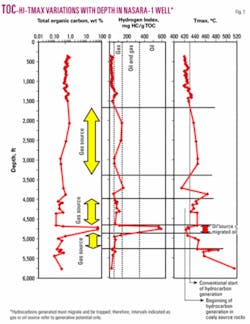
The TOC contents are generally poor to fair with a slight trend of decreasing values with depth (Fig. 5). However, at depths of 4,710-70 ft, very high TOC contents (52.1-55.2 wt %), (coal?) were recorded. With the exception of the high TOC contents in that interval, none of the other recorded TOC values exceeded 1%; about half of them ranged between 0.50 and 0.87%. Hydrogen indices (HIs) are also low and the highest value, apart from those in the coaly (?) interval, was 160 mg HC/g TOC (Fig. 5).
Within the supposedly coaly interval by contrast, HI values range from 564 to 589 mg HC/g TOC. Tmax values increase gradually with depth up to about 3,000 ft; thereafter, they show little discernible trend, although a very high value of 514° C. was recorded at the bottom of the well.
The thermal maturity represented by Tmax of 423-428° C. for the coaly interval equates to a vitrinite reflectance (Ro) of 0.56-0.58%, which in turn corresponds to subbituminous A coals.9 10
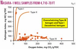
We note here and also in Obaje et al.10 that the maturities of coals are generally lower than those in the underlying and directly overlying shaly intervals. However, the reason for this is not yet understood. A plot of HI versus OI for the samples indicates that organic matter is predominantly of Type III kerogen (Fig. 6), except in the coaly interval where Type I kerogen is present.
Biomarkers
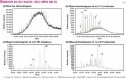
The total ion chromatograms of the saturated hydrocarbon fractions of the coaly samples show some ramping of unresolved complex mixtures, probably attributable to biodegradation (Fig. 7a).
Selected ion monitoring based on the m/z 71 of the saturated fractions shows biomarkers with a dominance of short-chain n-alkanes (C15-C25) (Fig. 7b), indicating that hydrocarbons were generated from algal-bacterial dominated source material. The pristane/phytane ratios of 0.8 to 1.3 point to anoxic to suboxic depositional conditions.
Steranes are dominantly of the 20R epimer form of C28 (Fig. 7d). This high contribution from C28 steranes is very significant and noteworthy. Huang and Meinschein12 proposed that a preponderance of C29 steranes would indicate a strong contribution from terrestrial organic matter, whereas dominance by C27 steranes would indicate deviation from marine (aquatic) phytoplankton. C28 steranes are generally present in the lowest proportions; however, their relative abundance could indicate a large contribution from lacustrine algae.
The high relative abundance of C28 in samples from the Nasara-1 well therefore indicates organic source deposition in a lacustrine environment (C28) with high algal-bacterial contents whose generated hydrocarbons have been intermittently subjected to anoxic to suboxic biodegradation processes.
Oil migration
The only evidence for assigning the interval 4,710-70 ft to a coaly lithology is the high TOC values. All the other data (HIs, Pr/Ph ratios, C28 steranes) point to a lacustrine source rock.
Equally, because no lacustrine source rocks have such high TOCs13 and in the absence of petrographic data at the moment, it is assumed that some oils generated from a probably deeper seated or laterally located (yet to be identified) lacustrine source rock must have migrated and adsorbed into the rock facies (Fig. 5), which were later intermittently subjected to anoxic to suboxic biodegradation processes.
It is therefore assumed that a coaly source rock was present into which also some oils from a lacustrine source have migrated. Coals on the other hand have been recognized as a source of hydrocarbons in many parts of the world.14-16
Coal has long been recognized as a source of gas, primarily methane and carbon dioxide, but its importance as a source of economic volumes of oil has been difficult to prove as coals are generally interbedded with shales, which are assumed to be the source beds. Increasing evidence, however, suggests that coals and associated Type III kerogens can yield not only gas or condensate17 but also significant quantities of oil.14 18 19
Exploration implications
It is probable that the general poor knowledge of the subsurface geology of this area, especially with respect to source rock development and petroleum system elements, may have been partly responsible for the unsuccessful results in the exploration campaigns carried out in the inland basins so far.
This work shows that the very high values of hydrogen indices and preponderance of C28 steranes in the interval 4,710-70 ft indicate that some oils generated from a probably deeper seated or laterally located (yet to be identified) lacustrine source rock must have migrated and adsorbed into a coaly facies.
Acknowledgments
This article is an outcome of analytical work carried out by the author at the Federal Institute for Geosciences and Natural Resources (BGR) in Hanover, Germany. The visit to Hanover was supported by the Alexander von Humboldt Foundation through a fellowship award in 2002-03. Dr. Hermann Wehner, Head of Organic Geochemistry Section at BGR collaborated in the study. Georg Scheeder, Annegret Tietjen, Angelika Vidal, Aenne Balke, and Monika Weiss are gratefully acknowledged for assisting with data generation. Chevron Nigeria Ltd. allowed independent assessment of its samples and gave permission to publish. ✦
References
1. Benkhelil, J., “The evolution of the Cretaceous Benue Trough, Nigeria,” Journal of African Earth Sciences, Vol. 8, 1989, pp. 251-282.
2. Mohamed, A.Y., Pearson, M.J., Ashcroft, W.A., Illiffe, J.E., and Whiteman, A.J., “Modeling petroleum generation in the Southern Muglad rift basin, Sudan,” AAPG Bull., Vol. 83, 1999, pp. 1,943-64.
3. Mohamed, A.Y., Illiffe, J.E., Ashcroft, W.A., and Whiteman, A.J., “Burial and maturation history of the Heglig field area, Muglad basin, Sudan,” Journal of Petroleum Geology, Vol. 23, No. 1, 2000, pp. 107-128.
4. Zanguina, M., Bruneton, A., and Gonnard, R., “An introduction to the petroleum geology of Niger,” Journal of Petroleum Geology, Vol. 21, No. 1, 1998, pp. 83-103.
5. Akande, S.O., and Erdtmann, B.D., “Burial metamorphism (thermal maturation) in Cretaceous sediments of the Southern Benue Trough and Anambra Basin, Nigeria,” AAPG Bull., Vol. 82, No. 6, 1998, pp. 1,191-1,206.
6. Whiteman, A., “Nigeria: Its Petroleum Geology, Resources and Potential,” Graham and Trotman, London, 1982, 381 p.
7. Akande, S.O., Ojo, O.J., Erdtmann, B.D., and Hetenyi, M., “Paleoenvironments, source rock potential and thermal maturity of the Upper Benue rift basins, Nigeria: implications for hydrocarbon exploration,” Organic Geochemistry, Vol. 29, 1998, pp. 531-542.
8. Carter, J.D., Barbar, W., Tait, E.A., and Jones, G.P., “The geology of parts of Adamawa, Bauchi and Borno Provinces in northeastern Nigeria,” Geological Survey of Nigeria Bull., Vol. 30, 1963, pp. 1-108.
9. Stach, E., Mackowsky, M-Th., Teichmueller, M., Taylor, G.H., Chandra, D., and Teichmueller, R., “Stach’s textbook of coal petrology,” Gebrüder Borntraeger, Berlin, 1982, 535 p.
10. Taylor, G.H., Teichmuller, M., Davies, A., Diessel, C.F.K., Littke, R., and Robert, P., “Organic Petrology,” Gebrueder Borntraeger, Berlin, Stuttgart, 1998, 704 p.
11. Obaje, N.G., Wehner, H., Scheeder, G., Abubakar, M.B., and Jauro, A., “Hydrocarbon prospectivity of Nigeria’s inland basins: From the viewpoint of organic geochemistry and organic petrology,” AAPG Bull., Vol. 87, 2004, pp. 325-353.
12. Huang, W.Y., and Meinschein, W.G., “Sterols as ecological indicators,” Geochimica et Cosmochimica Acta, Vol. 43, 1979, pp. 739-745.
13. Peterson, H., personal communications.
14. Hunt, J.M., “Generation of gas and oil from coal and other terrestrial organic matter,” Organic Geochemistry, Vol. 17, 1991, pp. 673-680.
15. Isaksen, G.H.,. Curry, D.J., Yeakel, J.D., and Jenssen, A.I., “Controls on the oil and gas potential of humic coals,” Organic Geochemistry, Vol. 29, 1998, pp. 23-44.
16. Wilkins, R.W.T., and George, S.C., “Coal as a source rock for oil: a review,” International Journal of Coal Geology, Vol. 50, 2002, pp. 317-361.
17. Tissot, B.P., and Welte, D.H., “Petroleum formation and occurrence,” Springer-Verlag, New York, 1984, 699 p.
18. Murchison, D.G., “Recent advances in organic petrology and organic geochemistry: an overview with some references to ‘oil from coal,’” Geological Society of America Special Publication 3, Vol. 32, 1987, pp. 257-302.
19. Petersen, H.I., Andsbjerg, J., Bojesen-Koefoed, J.A., and Nytoft, H.P., “Coal-generated oil: source rock evaluation and petroleum geochemistry of the Lulita oil field, Danish North Sea,” Journal of Petroleum Geology, Vol. 23, 2000, pp. 55-90.
The author
Nuhu Obaje ([email protected]) is professor of geology at Nasarawa State University, Keffi, Nigeria, dean of the faculty of natural and applied sciences, and head of the department of geology and mining. He held research tenures in the exploration departments of Chevron Nigeria Ltd. and Shell Petroleum Development Co. of Nigeria Ltd. He has BSc (Hons.) and MSc degrees in geology from the Ahmadu Bello University and a PhD from the University of Tuebingen.
