Gulf of Mexico reservoir properties are helpful parameters for explorers
A great deal has been published on discoveries, reserves, and production from the Gulf of Mexico, but little has been published on what reservoir properties are present.
Among these properties are those that influence reserves and production such as reservoir depth, formation pressure, productive area, reservoir temperature, pay zone thickness, API gravity, water saturation, and porosity. Permeability was not included because little such information was available.
No data on reservoir properties were available for reservoirs discovered after 1998.
Gulf reservoirs
At the end of 1999 the Gulf of Mexico had 25,107 reservoirs, according to a quick review of reservoirs from the Department of Interior’s MineralsManagement Service.
Pleistocene reservoirs numbered 10,104 or 40% of the total. The gulf had 6,408 Pliocene reservoirs or 26% of the total, 8,559 Miocene reservoirs or 34%, and 36 reservoirs of other ages or less than 1% of the total.
Total recoverable oil discovered on the Outer Continental Shelf and Slope through 1999 was reported to be 14.4 billion bbl, of which 11.4 billion bbl had been produced. The volumes were allocated 5.2 billion bbl or 36% in Pleistocene reservoirs, 4.2 billion bbl or 29% in Pliocene reservoirs, 4.9 billion bbl or 35% in Miocene reservoirs, and 10 million bbl or less than 1% in Oligocene, Cretaceous, and Jurassic reservoirs.
Total recoverable gas discovered through the end of 1999 was reported to be 161.4 tcf, of which 137.7 tcf had been produced.
The data in this article were derived from Louisiana, Texas, Alabama, and federal sources.
Because the only published data on reservoir properties were for discoveries prior to 1998, it is assumed that within limits these data may act as a general guide for data about other reservoirs.
Properties reviewed here were calculated from play data where a play was defined as a group of reservoirs related by origin, structural trap, source rocks, or seals and may include data from one or several fields.
Information on various property data was assembled for 91 plays by age. Not all data were available for all reservoirs: 67 reservoirs had no age assigned, and 15 other reservoirs had no data available. Reservoirs with little or no data on reservoir properties were not included in this review.
Overview of data
As averages provide a quick view of a large mass of unwieldy data and are one of the few ways that properties for a large number of reservoirs can be compared, averages were calculated for the total information available.
Depth of production averaged 8,092 ft and ranged from 1,500 ft to 21,591 ft. Formation pressure averaged 4,488 psi and ranged from 713 psi to 15,561 psi.
Productive area averaged 28,661 acres and ranged from 10 acres to 208,492 acres. Formation temperature averaged 179° F., and the range was 90-348° F. Pay thickness averaged 54 ft and ranged from 6 ft to 155 ft.
Oil quality averaged 39° gravity, and the range was 22-59° gravity. Water saturation averaged 30% and ranged from 15% to 51%. Porosity averaged 28% and ranged from 12% to 37%.
Data were available on only one Cretaceous reservoir.
Depth factors
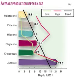
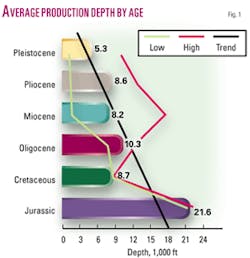
As would be expected, average production depths generally deepened with increased age (Fig. 1).
The depths of Pleistocene production ranged from 1,500 ft to 9,511 ft. Depth of Pliocene production ranged from 1,669 ft to 12,778 ft.
Miocene production ranged in depth from 1,838 ft to 17,721 ft, Oligocene production depths ranged from 7,986 ft to 12,295 ft, and depths of Jurassic production ranged from 21,500 ft to 22,600 ft.
As the influence of depth may be important to reservoir properties, several values from a shallow depth in each property were compared to a number of values at a deeper depth.
There were four plays with depths of less than 2,000 ft and five plays deeper than 15,000 ft. Pressure averaged 842 psi in the shallow zone compared with 12,402 psi in the deeper zone, a factor of nearly 15.
Reservoir area in the shallow productive interval averaged 1,858 acres compared with 16,584 acres in the deeper intervals, a factor of nearly 9. Average temperature in the shallow zone was 99° F. compared with 299° F. in the deeper zone.
Pay thickness averaged 50 ft in the shallow zone compared with 75 ft in the deeper zone. Water saturation averaged 27% in the shallow zone compared with 29% in the deeper zone.
Porosity averaged 33% in the shallow zones compared with 21% in the deeper zones.
Pressure, area
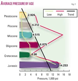
Average formation pressures generally heightened with increased age (Fig. 2).
Pleistocene pressures ranged from 713 psi to 5,813 psi. Pliocene pressures ranged from 880 psi to 6,846 psi.
Miocene pressures ranged from 880 psi to 15,561 psi, Oligocene pressures ranged from 3,629 psi to 9,699 psi, and Jurassic pressures ranged from 12,975 psi to 15,835 psi.
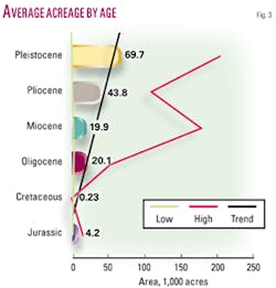
Field sizes as measured by average productive acreage tended to be smaller as formation age increased (Fig. 3).
Pleistocene values ranged from 10 acres to 208,492 acres. Pliocene values ranged from 667 acres to 109,461 acres.
Miocene values ranged from 639 acres to 179,490 acres. Oligocene values ranged from 2,763 acres to 56,342 acres, and Jurassic values ranged from 174 acres to 11,845 acres.
Formation temperature
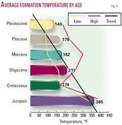
Average formation temperature generally rose with increased age (Fig. 4).
Pleistocene temperatures ranged from 90° to 188°. Pliocene temperatures ranged from 93° to 228°.
Miocene temperatures ranged from 102° to 305°. Oligocene temperatures ranged from 167° to 264°, and Jurassic temperatures ranged from 227° to 414°.
One wrinkle with temperatures as reported is a variation with depth. For instance, a temperature of 80° was reported at a depth of 7,182 ft in one area while a temperature of 83° came at a depth of 10,289 ft in another area.
Pay thickness
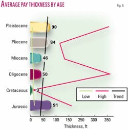
The trend in average pay thickness decreases with age except for the Jurassic value (Fig. 5).
Pleistocene pay thickness ranged from 9 ft to 1,412 ft. Pliocene pay thickness ranged from 6 ft to 135 ft.
Miocene pay thickness ranged from 10 ft to 155 ft. Oligocene pay thickness ranged from 13 ft to 36 ft, and Jurassic pay thickness ranged from 13 ft to 184 ft.
Oil gravity
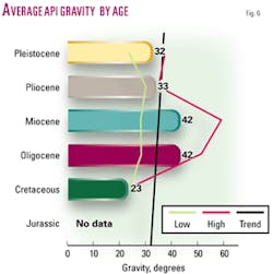
Overall, average gravity values tended to rise with increased age until the Cretaceous value (Fig. 6). No data were available for Jurassic values.
Pleistocene oil quality ranged from 22° to 37° gravity. Pliocene oil quality ranged from 30° to 35° gravity.
Miocene oil quality ranged from 28° to 58° gravity. Oligocene oil quality ranged from 43° gravity to 51° gravity. No gravity values were reported in Jurassic plays.
Water saturation
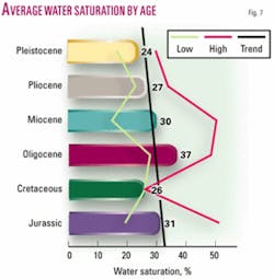
Average water saturation tended to increase with age (Fig. 7).
Pleistocene water saturation ranged from 17% to 30%. Pliocene water saturation ranged from 23% to 34%.
Miocene water saturation ranged from 15% to 51%. Oligocene water saturation ranged from 28% to 49%, and Jurassic water saturation ranged from 19% to 52%.
Porosity
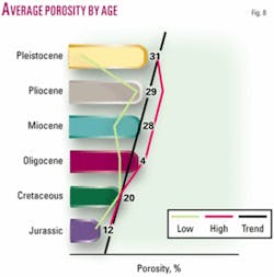
Average porosity decreased with increased age (Fig. 8).
Pleistocene porosity ranged from 29% to 35%. Pliocene porosity ranged from 27% to 37%.
Miocene porosity ranged from 18% to 34%. Oligocene porosity ranged from 20% to 30%, and Jurassic porosity ranged from 10% to 16%.
Water depth
The depth of water in which wells were drilled has nothing to do with reservoir properties, but it may be important as a drilling factor.
The depth of water of the reservoirs producing in this study averaged 104 ft and ranged from 11 ft to 605 ft.
The water depth of Pleistocene pays averaged 219 ft and ranged from 55 ft to 605 ft. The water depth of Pliocene pays averaged 234 ft and ranged from 133 ft to 603 ft. The water depth of Miocene pays averaged 71 ft and ranged from 11 ft to 200 ft.
The water depth of Oligocene pays averaged 45 ft and ranged from 16 ft to 69 ft, and the water depth of Jurassic plays averaged 41 ft and ranged from 12 ft to 60 ft. Water depth of one well drilled to a Cretaceous pay was 288 ft.
Trap types
Review of the type of traps in the gulf showed 32% of the traps were faulted anticlines, 18% were normal faults, and 14% were flank traps associated with salt or shale diapirs.
Fourteen percent of traps were in sediments overlying domes, 13% were in rollover anticlines, 3% were in anticlines, and 3% resulted from updip facies change. The other 3% were in five types of traps: reverse faults, turtle structures, updip pinchouts, permeability traps, and patch reefs.
Pleistocene traps were 29% faulted anticlines, 22% flank traps on salt or shale structures, and 16% overlying domes.
Pliocene traps were 31% faulted anticlines, 28% flank traps on salt or shale structures, and 17% normal faults.
Miocene traps were 40% faulted anticlines, 28% normal faults, and 16% overlying domes. Oligocene traps were 48% faulted anticlines and 48% rollover anticlines.
Jurassic traps were 75% faulted anticlines and 25% anticlines. The one Cretaceous trap was a patch reef.
Exploration application
Knowledge and understanding of reservoir properties is necessary to anticipate reservoir conditions that may be encountered in petroleum exploration, oil field development, and oil production, especially in an area as geologically complex and with such a range of depths as the Gulf of Mexico.
This type of information is required to understand and adequately evaluate an area and to be aware of and understand the problems, conditions, and reservoir relationships that may be present. Geologists and geophysicists need data to evaluate and estimate hydrocarbon presence, and even scattered information is better than no information.
Although as a result of reporting time limitations the range of these data are not as exact as one would like, they may be of some help in predicting possible reservoir conditions by ages and plays in the Gulf of Mexico.
Bibliography
Bureau of Economic Geology, “Atlas of Northern Gulf of Mexico Gas and Oil Reservoirs,” The University of Texas, Austin, 1999.
Minerals Management Service, “Estimated Oil and Gas Reserves, Gulf of Mexico, Report 2002-2007,”
The author
F.R. Haeberle ([email protected]) is a consulting geologist who moved to Delaware, Ohio, after 20 years in Dallas. He has worked for Standard Oil Co. of Texas, Atlantic Refining Co., Mobil Oil Corp., Mayfair Minerals, and J.J. Lynn Oil Division. He holds BS and MS degrees in geology from Yale University and an MBA degree in finance from Columbia University Graduate Business School.
