New, old plays in southern Uinta basin get fresh look with 3D seismic technology
The exploration boom is on again in the Uinta basin of northeastern Utah, thanks to sustained strong natural gas prices and the successful application of 3D seismic surveys. After more than 30 years of concentrated development drilling in the basin's several long-established oil and gas fields, the attention of the industry has been refocused on the vast underexplored areas in the remote southern Uinta basin and Book Cliffs.
The Uinta basin is a tremendously hydrocarbon-rich place where it is difficult to drill a hole that does not encounter at least a show of oil or gas.
It became an exploration target for several major oil companies immediately after World War II. Their objective was invariably oil, as there was no gas transportation system out of the basin until 1961.
Many exploration tests encountered significant gas shows, even if they did not find commercial oil production. Most of these holes were drilled and abandoned.
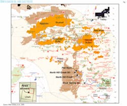
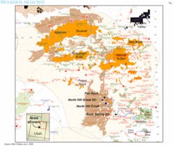
Many of the pioneering exploration geologists did first-class work in the Uinta basin from the late 1940s to the early 1960s, by which time they had discovered virtually all of the significant oil and gas accumulations producing in the basin today. The delineation and development of these early fields have been the primary activity of Uinta basin operators for the past 40 years (Fig. 1).
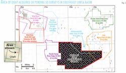
Since 2000, when Wind River Resources Corp. shot the first exploration-oriented 3D seismic survey in the Uinta basin, nearly 300 sq miles of 3D seismic data have been acquired, and 150 sq miles have been scheduled so far for field acquisition in 2005 (Fig. 2).
The 3D seismic activity prior to 2000 consisted of just two 7-sq-mile surveys conducted in known producing areas. Even during the heyday of Uinta basin exploration, from the late 1940s to the early 1960s, seismic data were not widely used because it was recognized that structure played a minor role as a trapping mechanism and 2D seismic surveys were not particularly effective at identifying the sand lenses and stream channel deposits that formed the stratigraphic traps for most fields.
Wind River Resources' 3D seismic survey was acquired on 28 sq miles of the Hill Creek Extension of the Ute Indian Tribe's Uintah and Ouray Reservation in late 2000. The North Hill Creek 3D, as it was called, was supported by a grant from the US Department of Energy. This survey was important because it proved that high-quality data could be obtained in an area that conventional wisdom had dismissed as unsuitable for 3D seismic applications due to extreme topography and the presence at or near the surface of highly reflective sandstones. It was also important because it led the way to new plays.
History of exploration
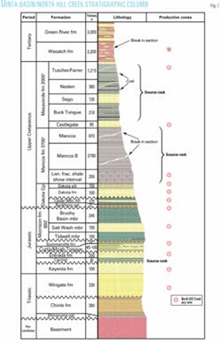
The first well drilled for oil in the Uinta basin was a 1900 dry hole located near tar sand outcrops in the PR Spring area of extreme southern Uintah County. Commercial gas production was discovered at Ashley Valley field in the Morrison formation in 1925 (Fig. 3). This gas was piped a few miles northeast to Vernal and consumed locally until World War II, when the pipeline was salvaged.
No other gas was sold from the Uinta basin until late 1961, when the Mountain Fuel Supply-Utah Natural Gas (now Questar) pipeline started delivering gas to cities on the Wasatch Front.
Oil exploration began in earnest toward the end of World War II when Carter Oil Co. (now ExxonMobil Corp.) initiated an intense effort in the Uinta basin.
In 1948 Salt Lake City-based Equity Oil found the first commercial oil production, again at Ashley Valley field, by drilling to the deeper Weber sandstone. Carter followed a year later with the 1949 discovery of Roosevelt field, which eventually expanded to become giant Altamont-Bluebell field.
Chevron discovered Red Wash field in 1951. Conoco discovered gas at Chapita Wells field in 1955, but gas was not sold until 1961 when other gas fields had been discovered in the immediate area. Infill drilling eventually joined these fields to form Greater Natural Buttes field.
Each of these fields produces from Tertiary reservoirs of the Green River formation and/or the Wasatch formation. Expanded to their current configurations, these fields have produced 85% of the estimated 500 million bbl of oil and 80% of the 2.5 tcf of gas that have been produced from the Uinta basin through 2004.
The southern Uinta basin, which to this day is not served by a paved road, has always been a difficult place to conduct oil and gas operations. It is as remote, rugged, and thinly populated as any area of comparable size in the Lower 48 states.
With ground elevations ranging from 6,000 ft to 8,000 ft, snow can be a problem for much of the year. Despite these obstacles, major oil companies explored the southern Uinta basin to some extent in the 1950s and 1960s. Important deep wells were drilled in the southern Uinta basin in this period, but few found oil and most were plugged.
Several important gas fields, including San Arroyo, Westwater, Bar X, and Bryson Canyon were discovered and developed, delivering gas to the Northwest Pipeline in adjacent Colorado. These fields developed gas reserves in the Lower Cretaceous Dakota sandstone and Cedar Mountain formation and in the Jurassic Morrison and Entrada formations.
Since the early 1960s these wells have contributed 10% of the gas produced in the Uinta basin.
Until quite recently the market for Uinta basin gas was weak. Most of the wells in the southern area could probably have produced more than their cumulative production indicates, as they have been subject to seasonal operation and sporadic curtailment for decades.
Despite these operating constraints, many wells have cumulative gas production exceeding 1 bcf.
Through 2004 there are 11 fields that include at least one such well, and they contain a total of 263 wells. Eighty-six of these Dakota, Cedar Mountain, Morrison, and Entrada wells, or 33%, have exceeded 1 bcf.
Cumulative production among these wells is distributed as follows: 47 wells, 1-2 bcf; 29 wells, 2-5 bcf; 9 wells, 5-10 bcf; 1 well, >10 bcf.
All but 5 of these wells were drilled without benefit of 3D seismic data. Most were drilled during two bursts of drilling activity: the first in the late 1950s through early 1960s and the second in the late 1970s through early 1980s.
The Green River and Wasatch plays in the northern and central parts of the basin were expanded periodically in response to oil price changes. Although exploration drilling took place, it looked more exploratory at the time than it really was.
The number of fields decreased with time as many individual fields grew together to form a few larger fields. This was particularly true in the Greater Altamont-Bluebell and Greater Natural Buttes areas.
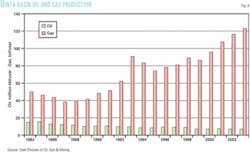
From the mid-1980s through the late-1990s, a time when low oil and gas prices were the rule, little high-risk drilling took place in the Uinta basin because it was considered a high-cost area in which to drill and operate. Oil production declined steadily while gas production more than doubled in this period in response to infill drilling in the Natural Buttes area (Fig. 4).
North Hill Creek 3D
Based on experience in the Uinta basin dating to 1983, Wind River Resources and its geological/geophysical consultants, Black Coral LLC, believed that 3D seismic technology would be an effective exploration tool in the basin.
In late 1999 a proposal was submitted to the DOE that resulted in a grant to fund a 15-sq-mile 3D seismic survey on lands in the nearly unexplored Hill Creek Extension of the Ute Indian Tribe's Uintah and Ouray Indian Reservation.
The survey was expanded to 28 sq miles to include Del-Rio Resources-operated Flat Rock field, a small oil and gas field which at the time was producing primarily from the Wasatch formation.
Wind River Resources conceived its North Hill Creek exploration program to improve drilling success rates by using 3D seismic technology to map structures and stream channels. Field data acquisition took place in the fall of 2000, the data were processed over the following winter, and the initial interpretation effort was made in the spring of 2001.
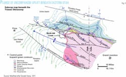
The survey area included the Hill Creek anticline, a structure associated with the Garmesa Fault Zone, which forms the northern edge of the northwest-plunging Uncompahgre uplift (Fig. 5). San Arroyo field is located on a similar structure.
The primary objectives of Wind River's effort were the potential channel sand reservoirs in the shallow Tertiary Wasatch formation (3,500 ft) and in the deeper Cretaceous Dakota and Cedar Mountain formations (10,000 ft). Secondary objectives included the Mesaverde Group rocks, fractured intervals in the 3,700-ft-thick Mancos shale, and the eolian sands of the Entrada formation.
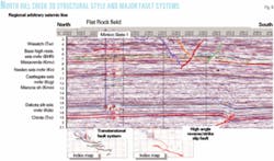
The interpreted 3D data provided a new image of the northwest-trending Hill Creek anticline and the fault on its south flank (Fig. 6). The fault was found to be a high-angle reverse fault with some apparent lateral movement.
The underlying fault grew up through the Mesozoic sedimentary rocks from the crystalline basement. The shallower Tertiary rocks are cut by a series of smaller normal faults, possibly resulting from the relaxation of the forces that caused the deep-seated fault.
The Hill Creek anticline is an asymmetric structure with its crest migrating southward with depth. The north flank of the anticline dips gently in comparison to the abruptly faulted south flank. The crest of the anticline in the Mesozoic is a mile or more south of the locations predicted in earlier publications based on surface work.
The importance of structure as a trapping mechanism is not yet fully understood. It is thought to be important in some cases in the Wasatch formation, and perhaps in the Dakota and Cedar Mountain formations. Fracturing associated with the faulting is clearly associated with production and large gas shows in the lower Mancos shale.
Wasatch formation
Wind River Resources initially focused on the Wasatch formation for early drilling targets.
The Wasatch formation has produced more than 280 million bbl of oil and 480 bcf of gas in the Greater Altamont-Bluebell Area. This oil is world-famous for its bright yellow color, high paraffin content, and resulting high pour point.
Oil is also produced from the Wasatch at Flat Rock field and has the bright yellow color and wax but not the high pour point. No other oil like it has been found anywhere in the area.
The Tertiary Wasatch formation consists of lake margin fluvial and alluvial plain sediments. Lake Uintah, into and around which it was deposited, was a significant body of water with a history of rising and falling water levels influenced by the periodic and sometimes major tectonic movement of the San Rafael, Uncompahgre, and Uinta uplifts and intermontane basin subsidence.
The North Hill Creek 3D area is located on the southwestern shore of the lake. Braided streams and fresh water deltas brought sediment from southern highlands towards the north and northeast. Seismic mapping of several intervals showed meandering, relatively low-amplitude events interpreted to represent marginal lacustrine channels or nonlacustrine alluvial-plain channels.
In this area the Wasatch is 1,200 ft thick and consists of fluvial channels cut into finer-grained alluvial plain sediments. In the North Hill Creek area to date production has been confined to the bottom 700 ft of the formation.
An average pay or potential pay interval in Flat Rock field is 12 ft, or about 2 milliseconds. Often, several pays or potential pays lie within one cycle of the seismic traces. One can envision stacked channel sands formed by a channel remaining in one position over time and being represented by a single trough.
Wind River drilled two productive wildcat Wasatch wells at North Hill Creek based on sequence stratigraphic principles in combination with detailed mapping of the 3D seismic data.
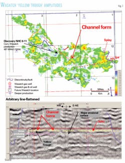
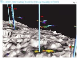
One test, the NHC 6-11 well, targeted several channel forms, one of which is shown in Fig. 7. Fig. 8 is a 3D image of the NHC 6-11 penetration of the gross lower channel objectives. This well encountered pay sands within the seismic channel forms and has produced 500 MMcf of gas through 2004.
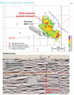
The second well appears to be in a preserved erosional remnant. Fig. 9 shows the interval of production in the gas and oil prone package encountered in the North Hill Creek 11-12. It is clear that an erosional event isolates a remnant of a previously deposited channel package.
The base of the erosional event apparently provides a top seal and lateral seals to the south and west. A down-to-the-east fault bounds the east side of this older channel package remnant. Assuming 40-acre spacing, several offsets have yet to be drilled.
While channels contain the requisite sand reservoirs, this work has shown that existing Wasatch production in the area may be partially controlled by down-to-the-south faulting on the north flank of the Hill Creek anticline. In addition, mapping unconformities is important since subsequent erosional events affect migration pathways and provide seals for hydrocarbons trapped in erosional remnants.
Drilling results
As noted above, Wind River Resources' first well targeted channel sands in the Wasatch formation at approximately 3,500 ft.
The Wasatch normally requires stimulation, but this well was completed naturally at the rate of 1.6 MMcfd. The natural completion confirmed core and log data that suggested Wasatch reservoir quality superior to that found toward the center of the basin.
To date 16 wells have been drilled and completed on the basis of the interpreted North Hill Creek 3D survey. Commercial gas production has been achieved from 12 separate pays ranging in depth from 3,500 ft to 12,000 ft.
The deeper pays, the eolian Entrada and Wingate sands, have been among the most important to date with several wells establishing initial production in excess of 5 MMcfd. Since the Entrada was originally considered a long-shot secondary objective and the Wingate was not expected to be productive, these have been pleasant surprises.
It should also be noted that this is believed to be the first Wingate production anywhere. And at greater than 1 MMBtu/Mcf, the Entrada gas is of higher quality than has been the case previously in the Uinta basin.
The future
The 3D seismic survey-driven exploration of the Uinta basin is just getting under way.
It is clear that a well-designed survey can overcome the inherent obstacles previously thought to be insurmountable. Excellent data quality has been Wind River Resources' experience in the two surveys it has conducted to date.
The immediate focus of most active exploration programs appears to be the southern Uinta basin because it has been neglected for so long, new gas plays have been discovered, and many potential pays are much shallower than they are in the central and northern parts of the basin.
Although the 3D mapping of Dakota and Cedar Mountain channel sands has proven more difficult than was anticipated at North Hill Creek, it now appears that this is because such features are confined to a relatively small portion of the survey area. Initial interpretation of the Rock Spring 3D, a few miles to the southeast, seems more promising.
The $56,000/sq mile cost of the North Hill Creek survey in 2000 was a relative bargain. Although this was a densely spaced survey, it was designed to avoid heliportable shot hole drilling, and only 20% of the source points were dynamite shot holes.
The larger Rock Spring 3D Survey involved considerable heliportable drilling and a shot hole/vibrator ratio of 35% versus 65%. This late 2004 survey cost about 50% more than North Hill Creek and is probably a better indicator of current costs.
With oil and gas prices at current levels, interest in the more mature parts of the Uinta basin is certain to increase. There is every reason to think that 3D seismic technology would be a useful tool for improved understanding of the highly complex Wasatch reservoirs in the Altamont-Bluebell area, which has seen little drilling since 1990.
The technology may also be applicable to exploring the deeper Mesaverde and Mancos opportunities beneath the Wasatch formation in the Natural Buttes area.
Acknowledgments
The authors thank Denise Harrison, Fall-Line Exploration Inc., for her detailed mapping and contributions to and critical review of this article, and Bill Keach, Landmark Graphics Corp., for preparing the 3D graphics. The authors also thank David Allin, Del-Rio Resources, for his input to discussions of geology in the survey area, and Jake Henderson, Black Coral LLC, and John Eckels for figure editing. Finally, the authors thank the US Department of Energy for providing seed funding for the 3D seismic survey that made this project possible.
This report was prepared as an account of work partially sponsored by an agency of the US government. Neither the government, nor any agency thereof, nor any of their employees, makes any warranty, express or implied, or assumes any legal liability or responsibility for the accuracy, completeness, or usefulness of any information. DOE Grant DE-FG26-00BC15193.
Bibliography
Abbott, Ward, "Tertiary of the Uinta Basin," in Intermountain Association of Petroleum Geologists 8th Annual Field Conference Guidebook, 1957, pp. 102-109.
Burchell, P.W., "Historical Development of Oil and Gas Production in Utah's Uinta Basin," in Intermountain Association of Petroleum Geologists 13th Annual Field Conference Guidebook, 1964, pp. 181-185.
Chidsey, Jr., Thomas C., Wakefield, Sharon, Hill, Bradley G., and Hebertson, Michael, "Oil and Gas Fields of Utah," Utah Geological Survey Map 203 DM, 2004.
Folsom, L.W., "Economic Aspects of Uinta Basin Gas Development," in Beebe, B.W., ed., "Natural Gases of North America," AAPG Symposium, Vol. 1, Memoir 9, 1968, pp. 199-208.
Osmond, John C., "Geologic History of the Uinta Basin, Utah," AAPG Bull., Vol. 49, No. 11, 1965, pp. 1957-1973.
Osmond, John C., "Greater Natural Buttes Gas Field, Uintah County, Utah," in Fouch, T.D., et al., eds., "Hydrocarbon and Mineral Resources of the Uinta Basin, Utah and Colorado," Utah Geological Association Guidebook 20, 1992 Field Symposium, pp. 143-163.
Osmond, John C., "Tectonic History of the Uinta Basin, Utah," in Sabatka, E.F., ed., "Guidebook to the Geology and Mineral Resources of the Uinta Basin—Utah's Hydrocarbon Storehouse," Intermountain Association of Petroleum Geologists 13th Annual Field Conference, 1964, pp. 47-58.
Osmond, John C., Locke, R., Dille, A.C., Praetorious, W., and Wilkins, J.G., "Natural Gas in Uinta Basin, Utah," in Beebe, B.W., editor, "Natural Gases of North America," AAPG Symposium, Vol. 1, Memoir 9, 1968, pp. 174-198.
Picard, M. Dane, ed., "Geology and Energy Resources, Uinta Basin of Utah," Utah Geological Association Guidebook, 1985.
Robertson, J.M., and Broadhead, R.F., project directors, "Atlas of Major Rocky Mountain Gas Reservoirs," New Mexico Bureau of Mines and Minerals Resources, published for a consortium of agencies including the Gas Research Institute, Colorado Geological Survey, Utah Geological Survey, and Geological Survey of Wyoming, 1993.
Sabatka, Edward F., ed., "Guidebook to the Geology and Minerals Resources of the Uintah Basin—Utah's Hydrocarbon Storehouse," Intermountain Association of Petroleum Geologists, 13th Annual Field Conference, 1964.
Stone, Donald S., "Tectonic History of the Uncompahgre Uplift," in Veal, H.K., ed., "Exploration Frontiers of the Central and Southern Rockies," RMAG Symposium, 1977, pp. 23-30.
Suek, David H., and Miller, Robin E. Glanville, "San Arroyo," in Hill, B.G., and Bereskin, S.R., "Oil and Gas Fields of Utah," Utah Geological Association Publication 22, 1993.
Utah Department of Natural Resources, December 2003 and November 2004 Oil and Gas Production Reports, State of Utah, Division of Oil, Gas and Mining.
Young, Robert G., "Lower Cretaceous Rocks of Northwestern Colorado and Northeastern Utah," in Bolyard, D.W., ed., "Deep Drilling Frontiers in the Central Rocky Mountains," RMAG 1975 Symposium, pp. 141-147.
The authors
Marc Eckels (mte@ ubtanet.com) is vice-president and chief operating officer of Wind River Resources Corp., with offices in Salt Lake City and Roosevelt, Utah. He has lived and worked in the Uinta basin for more than 20 years. He is responsible for managing exploration, drilling, completion, and production operations for Wind River and leads the team of Denver-based geological and geophysical consultants that has designed, executed, and interpreted two 3D seismic surveys in the southern Uinta basin. His previous work involved operations management in giant Altamont-Bluebell field, Utah, and Kevin-Sunburst field, Montana, among others. He has a BS in geology from Dartmouth College.
David H. Suek (dhsuek@ bclimited.com) is a manager of Black Coral LLC, Denver. He has worked on oil and gas projects in the Uinta basin for more than 20 years. He manages the geological and technical team that conducted the 3D acquisition, prospect development, and drillsite selection for Wind River Resources in the southern Uinta basin. His previous Uinta basin work involved development geology at Altamont-Bluebell field. Outside the Uinta basin, his team is focused on the San Joaquin and Sacramento basins in California. He has BS and MS degrees in geology from California State University, Fresno.
Paul Harrison (pauldeniseh@ comcast.net) is a principal of Fall-Line Exploration Inc., Dillon, Colo. He has more than 40 years' experience in the international oil and gas industry, primarily as an exploration geophysicist. He has a BS in geophysics from the Colorado School of Mines and an MS in mathematics from the University of Colorado, Boulder.
