New interpretation reveals potential in onshore Algoa basin, South Africa
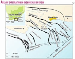
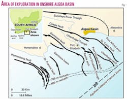
The Algoa basin is one of several Mesozoic sedimentary basins located along the southeastern margin of South Africa. The basin is of rift origin and is subdivided into three half grabens, the offshore Port Elizabeth and Uitenhage troughs and the onshore Sundays River Trough1 (Fig. 1).
This article highlights the results of a recent reappraisal of the petroleum geology of the South African onshore Algoa basin. Exploration, initiated in the 1960s, has focused on a trend of structural closures and has involved the drilling of 24 wells in the onshore basin.
In spite of encouraging hydrocarbon shows in some of the 9 offshore and 24 onshore wells drilled, no commercial hydrocarbon discovery has been made to date. However, a critical review of the regional geology, drilling results, and application of latest concepts in sequence stratigraphic interpretation provides a better understanding of the area's petroleum prospectivity.
Tectonic setting
Erosion, sediment dispersal, and deposition during the Cretaceous period are important from an economic point of view, as this period represents the time of most proven oil generation and entrapment in southern Africa.
The breakup of Gondwanaland was accompanied by extensive erosion during which new base levels were established on the continent. The formation of Mesozoic half grabens and the initiation of rifting in the southern coast of South Africa are related to the Jurassic separation of East and West Gondwana.2 Extensional stresses caused by rifting reactivated Precambrian and Paleozoic lineaments, resulting in major basin-bounding normal faults such as the St. Croix and Port Elizabeth faults (Fig. 1).
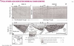
Collapse along these boundary faults created several Mesozoic depocenters, namely the Sundays River, Uitenhage, and Port Elizabeth troughs1 (Fig. 2). The troughs are separated from each other by highs of Paleozoic sediments composed mostly of the Ordovician to Silurian Cape Supergroup.3
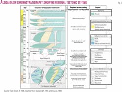
Active movement on the boundary faults ceased in the Late Valanginian. Regional uplift and thermal subsidence control subsequent basin development and sedimentation.4 Fig. 3 provides a summary of the regional tectonic setting and sequence stratigraphy of the Algoa basin.5
Although the bulk of the late Jurassic to early Cretaceous sediments is offshore, some of these Mesozoic half grabens are preserved as onshore paleo- basins. The largest onshore extension of these rift basins is the Algoa basin, which extends north and east of Port Elizabeth (Fig. 1). This basin represents a surface area of some 4,200 sq km and extends offshore into Algoa Bay.3
Basin stratigraphy
Rift-fill in the Algoa basin is characterized by Enon conglomerates, which occur as alluvial fan deposits in the proximal basin edge and active fault areas.
Sediments of the Enon formation consist of poorly sorted conglomerates interbedded with subordinate sandstones and claystones. The coarse clasts are predominantly basement-derived quartzites.2
The Enon conglomerates grade laterally and vertically into the Kirkwood formation, which consists of a thick succession of marine, lacustrine, and fluvial sands and muds. The Colchester member is a distinctive lithostratigraphic unit that occurs near the base of the Kirkwood formation.
Facies changes represented by the different sediments vary from shallow marine, estuarine to freshwater fluvial plain environments.2 The Colchester member, with a thickness of up to 200 m, is the main source rock for oil expulsion in the onshore Algoa basin. The maximum thickness of the Kirkwood formation including younger coastal to marine lithologies exceeds 2,000 m. The targeted sandstones are interpreted to be within the lower stratigraphic levels of the Kirkwood formation.
The shallow marine Sundays River formation, consisting of clays, silts, sands, and secondary limestone and gypsum, overlies the Kirkwood formation and represents an overall marine transgression.
In the late 1960s two wells, AL-1/69 and CO-1/67, recorded live oil shows.
The analysis of cores, geophysical logs, and drillstem tests confirms source rock potential and reservoir rock quality. Subsequent drilling in the early 1970s focused on structural targets around the rim of the basin. The stratigraphic nature of the trapping mechanism in the AL-1/69 well was not fully appreciated at the time. Critical petroleum factors are summarized below.
Source rocks
The Colchester member of the Kirkwood formation contains source potential for liquid hydrocarbons over intervals of dark, organic-rich shales.6
The dark, unoxidized, kerogen-rich shale beds are inferred to have been deposited under varied conditions that include estuarine, marine, and lacustrine. However, the Sundays River Trough is interpreted to be dominantly lacustrine.
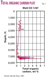
Well CO-1/67 intersected about 18 m of dark shale within 100 m of basal Colchester sediments.6 Total organic carbon for the darkest shales averages just less than 3%, but some values exceed 6% (Fig. 4).
Sapropelic and cuticular material in Colchester sediments have been found to be generally high, with sapropels being dominant.7 In addition, samples contained over 60% fluorescent macerals.6 Palynologists noted that 80% of the kerogen was amorphous material. The oil-prone nature of these shales is confirmed by high S2 and hydrogen index (approaching 500) values.6
Reservoir
Relatively thin, low permeability sandstone beds that exhibit porosities of 10-12% were measured from cores retrieved in borehole AL-1/69. Drilling breaks typically occurred in the basal marine sandstones.
A sequence analysis based on the log interpretation of AL-1/69 indicates basinward and landward barrier bar development at the transitional top of the Colchester stratigraphic level, very near the prognosed borehole location.
It is estimated (based on permeability, pressure, and thickness values) that a minimum flow rate of a few hundred barrels of oil per day per well might be attained at depths of 3,400-3,500 m in the Kirkwood beds.8
Typical Kirkwood beds, as intersected by previous wells, indicate that the porosities, permeabilities, number of sandstone bodies, and thickness improve in wells east of Coega (Fig. 1).8 Sandstones in the overlying Kirkwood have an average thickness of 8.5 m and an average porosity of 18%.
The barrier bar target sandstones are predicted to attain a thickness of up to 6 m. Such depositional systems would straddle the paleoshoreline and are estimated to be developed along strike for 4-6 km east of borehole AL-1/69.
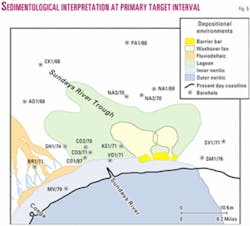
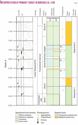
Based on the sedimentary model (Fig. 5) and sequence stratigraphic interpretation at least three barrier bar systems, at the bases of parasequences B, C, and D (Fig. 6) could be expected to be developed landward of the well AL-1/69 location.
Seals
Sequence stratigraphic modeling predicts adequate seal intervals associated with the lateral shaleout of barrier bar reservoir sandstones, the downdip facies changes to inner neritic shales, and the updip facies changes to lacustrine shales.
Relatively thick shales within parasequences A, B, C, and D (Fig. 6), whether marine or lacustrine in nature, may be effective base and top seals, resulting in discrete shale encapsulated reservoir sandstones.
Trapping mechanisms
Stratigraphic trapping, by way of local depocenter control and onlapping of the prospective sediments, is confined to an area straddling the coastline from close to the Colchester wells (CO-wells) eastward for some 15 km (Fig. 5). Much emphasis during past exploration efforts was placed on shallower structural closures and the drilling of apparent flushed structural traps.
The key to exploration in the basin lies in stratigraphic trapping mechanisms. Updip stratigraphic closures as a result of facies change from sandy coastal systems to lacustrine shales are complemented by the sequence stacking pattern and sedimentological interpretation, which in turn are based on biostratigraphy and geophysical log data.
2D seismic profiles clearly denote the absence of any significant structure or fault-related complication in the prospect area. The trap integrity in the target area has been stable with respect to regional tectonics since at least late Cretaceous time.
Migration paths
Short distance migration from the underlying and interbedded Colchester source rocks have been proven to reach the AL-1/69 location and may be enhanced by minor downdip fault systems associated with the St Croix fault.
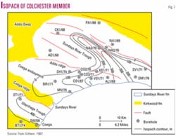
Migration along bedding alignments in the prospect area is interpreted to conform to the geometry of the Colchester depocenter (Fig. 7).
Drillstem tests
The following provides a brief summary of the most relevant drillstem tests (DST) performed:
Well AL-1/69, DST 6a (11,866-943 ft).
Reason for test: Cuttings displayed good visual porosity and fair fluorescence. The composite log indicates that the test covered the cored and noncored sandstone zones.
Results: No flow of formation fluid was recorded, and the geophysical logs fail to provide any encouraging evidence, either. It is likely that the 21/2-month gap between testing and logging introduced several complications to the interpretation. The log interpretation did not provide any qualitative indications of permeability, appreciable porosity, or hydrocarbon presence. The discrepancy, of course, lies with the fluorescing porous sandstone cuttings. However, residual oil could be responsible for the fluorescence.9
Well AL-1/69, DST 7 (12,083-148 ft).
Reason for test: Live oil was recovered in the cored sandstone. In addition, strong yellow fluorescence was recorded from the cuttings when drilling the sandstone above the tested interval. Core analysis results indicated porosities up to 13.5% and permeability up to 1.3 md.
Results: Although mechanically sound, the test failed to produce any noticeable hydrocarbons in spite of strong petrophysical evidence indicating the presence of movable oil.
Buildup analysis yielded an effective permeability of 0.05 md. This value is unrealistically low since the average core permeability of the lower zone only is 0.6 md. It is probable that the interval was not properly tested or that the wrong interval may have been tested.
There is the opinion that, as the drillpipe was not strapped while coming out of the hole before the test, the packer depth was probably wrong and that an entirely different zone or only the lowermost portion of the planned zone may have been tested. The geological well completion report9 of AL-1/69 refers to the possibility that the shallower sandstone in the interval was excluded from the test.
This error may have been more extensive as testing was conducted prior to the acquisition of geophysical logs. In addition, the DST methodology at the time lacked correlation runs that are generally used to verify the correct setting depth of the packer. The operator made a large effort to explain this great disappointment.10 The total lack of a result remains an anomaly, particularly if the zone was tested correctly. If it is assumed that only the lower zone was tested, the expected oil rate should have been between 12 and 16 b/d (using the semi steady state inflow equation for oil and assuming a skin of zero and 10 ft thickness).
Well CO-1/67, DSTs 8c (7,127-7,316 ft) and 8f (7,096-7,581 ft).
Reason for test: Oil was found in fractured shale at a shallower level than in borehole AL-1/69.
Results: The waxy oil recovered displays a density of 36º gravity and a viscosity of 1.1 cp at 210º F.
The primary target
The marine influenced sedimentary interval between 11,700 ft and 12,500 ft in borehole AL-1/69 is the primary target interval in the prospect area.
Live oil shows and low water saturation values of relatively thin sandstone beds were confirmed in cuttings, cores, and well logs. Low permeabilities accompanied by poor DST practices precluded oil flowing to surface.
A detailed interpretation of depositional environments, sequence architecture, and stacking patterns allows for predictive distribution of reservoir facies and geometries away from borehole AL-1/69. The proposed new well is planned to intersect barrier bar sandstones and is to be drilled some distance east of the AL-1/69 location.
Initial OIP estimation
In order to avoid subjective expressions of confidence as much as possible, the different geological attributes were assessed separately, each considered to be independent when dealing with a single primary target zone.
All aspects regarding source rock quality, quantity, expelled hydrocarbons and the timing thereof, migration pathways, and the presence of a stratigraphic trapping mechanism with base, top, and lateral seals are considered to be favorably in place that is, with respect to drilling a successful exploration well.
The presence of potential reservoir sandstones is considered to be high, but quantity and quality depend largely on the accuracy of the predictive model, which in turn directly affects deliverability and economic viability.
At a geological weighted probability scale ranging from a 10% "high-risk geological factor" to a 90% "virtual certainty," the reservoir is rated as a "significant uncertainty" spanning a 40-60% probability.
Stock tank oil initially in place (STOIIP) calculations were made using the following equation:
where:
N = stock tank oil initially in place (stb), A = area in square meters, h = height in meters, f = porosity (fraction), Sw = irreducible water saturation (fraction), and Bo = oil formation volume factor (rb/stb).
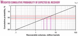
In order to arrive at a cumulative log probability distribution of recoverable oil, two calculations are made at low-side (P90) and high-side (P10) outcomes, which can then be used to evaluate P50 reserve values.
Low-side (P90) STOIIP are considered to reflect the probable oil volume that has been discovered in a single sandstone bed as intersected in borehole AL-1/69, where:
Recoverable oil is estimated using a recovery factor of 33%, resulting in a total of 0.56 MMstb recoverable oil.
High-side (P10) STOIIP are considered to include four sandstones reservoirs with an average thickness of 5 m each and an average area of 7,200,000 sq m. The oil volume of four sandstones is calculated below:
Recoverable oil is estimated at 26.4 MMstb, using a recovery factor of 33%.
Using the low-side STOIIP as a P90% extrapolation to the high-side STOIIP P10% results in a cumulative log probability distribution that indicates that recoverable oil in the P40% to P60% probability window ranges from just about 2.6 MMstb to 5.7 MMstb of oil recoverable (Fig. 8).
Data encouraging
Although the quantity and quality of the data over the regional onshore area may be sparse, reprocessed seismic profiles and the recent reevaluation of source rock potential and sedimentary modeling encourage further exploration.
A proven hydrocarbon system of source rocks expelling oil since late Cretaceous times with favorable migration pathways to proximal stratigraphically trapped sandstones exists. However the quality and thickness of reservoir sandstones remain the principal geological risk factor. Recoverable oil has been estimated to be 3.8 million stb at a 50% weighted probability.
In addition to geological factors, the prospect area is ideally located with respect to a ready market, modern harbor at Port Elizabeth, and the Coega deepwater harbor project under construction 20 km east of Port Elizabeth.
References
1. Bate, K.J., and Malan, J.A., "Tectonostratigraphic evolution of the Algoa, Gamtoos and Pletmos Basins, offshore South Africa," in de Wit, M.J., and Ransome, I.G.D., eds., "Inversion Tectonics of the Cape Fold Belt, Karoo and Cretaceous Basins of Southern Africa," A.A. Balkema, Rotterdam, 1992, pp. 66-76.
2. Dingle, R.V., Siesser, W.G., and Newton, A.R., "Mesozoic and Tertiary geology of Southern Africa," A.A. Balkema, Rotterdam, 1983, 375 p.
3. McMillan, I.K., Brink, G.J., Broad, D.S., and Maier, J.J., "Late Mesozoic Sedimentary Basins Off the South Coast of South Africa," in "Sedimentary Basins of the World, African Basins," Selley, R.C., ed., Elsevier Science BV, 1997, pp. 319-376.
4. Fouche, J., Bate, K.J., and Van der Merwe, R., "Plate tectonic setting of the Mesozoic Basins, southern offshore, South Africa: a review," in de Wit, M.J., and Ransome, I.G.D., eds., "Cretaceous Basins of Southern Africa," A.A. Balkema, Rotterdam, 1992, pp. 33-48.
5. Singh, V., "The Petroleum Geology of the Algoa Canyon, Offshore Algoa Basin," J. Afr. Earth Sci., GSA 11, abs., Vol. 33, 1999. [PR150.]
6. Van der Spuy, D., "Geochemistry Synthesis Report–Onshore Algoa Basin," SOE-PLU-RPT-040, Soekor Petroleum Licensing Unit, 1997, 9 p. (PSV2794).
7. McLachlan, I.R., and Scott, L., "CO1/67 Composition of Organic Material, Mesozoic Palynology," 1973, p. 1 (SV2077).
8. Schlein, N., "Assessment of the Oil Potential in the Algoa Basin," prepared by Natural Resources Research & Development (Pty.) Ltd., Energy Resources & Mining Corp. Ltd., Ch. 1-7, 1986 (SV2211).
9. Van Wyk, S.J., "Geological Well Completion Report of Borehole AL 1/69," Southern Oil Exploration Corp. (Pty.) Ltd., 1971, 55 p. (SV2401, SV745a & b).
10. Leith, M., "A Summary of Drill Stem Test Data of the Algoa Basin Rotary Boreholes with Special Reference to Formation Damage," 1971, 25 p. (SV2082).
The authors
Varsha Singh ([email protected]) joined Exxoteq as new ventures exploration geoscientist after 5 years at Petroleum Agency South Africa mapping and identifying prospective petroleum areas off South Africa's east coast. She has a BSc (Hons.) from the University of Durban-Westville.
Gerhard Brink acted as Exxoteq managing director for one year and now focuses on technical projects. He has more than 20 years' of geologic and geophysical experience with Soekor Ltd., Petrocorp (Pty.) Ltd., BHP Petroleum Australia, Bureau of Economic Geology, and Petroleos de Venezuela.
Henk Winter supervised the major geological advances in the onshore Algoa basin in 1967-72. He started in 1949 as most junior geologist on an Archean Witwatersrand gold mine. He was a PhD candidate on the Ventersdorp Supergroup when appointed in 1965 as leading geologist for Soekor.
