Geology will support further discoveries in Gulf of Guinea's Golden Rectangle
The oil and gas industry has been on an "elephant hunt" off West Africa for the past decade. This elephant hunt, or search for giant offshore oil fields, is focused on geologic sweet spots in the Gulf of Guinea and is most active in the offshore sectors of Nigeria, Equatorial Guinea, and Angola.
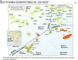
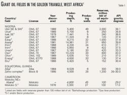
One of the richest and most prolific of these sweet spots is a 1.2 million acre offshore tract that we call the Gulf of Guinea's "Golden Rectangle," where recoverable oil reserves are reported in excess of 5 billion bbl and oil production exceeds 1 million b/d.
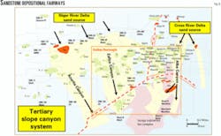
The Golden Rectangle is located near the offshore intersection of the maritime boundaries of Nigeria, Equatorial Guinea, and Cameroon (Fig. 1).
The geological and engineering expertise gained from the exploration and exploitation of the Golden Rectangle's oil reserves over the past 15 years has provided a template for hydrocarbon exploration and production into other deepwater areas of Nigeria and Equatorial Guinea. This expertise will be crucial to the successful development of the Nigeria-Sao Tome Joint Development Zone, where 6 to 12 billion bbl of oil are mooted.
We believe that an additional 1 to 2 billion bbl of oil will be discovered in the Golden Rectangle in the next 5 years as the current round of exploration and development continues.
In this article we review the hydrocarbon system of the Golden Rectangle area that is yielding a large concentration of proven hydrocarbon reserves and intensive ongoing exploration and development activity.
Land of the majors
Historically, oil majors ExxonMobil, Shell, and Total have dominated this area through their respective operating subsidiaries Mobil Producing Nigeria Unltd., Pecten Cameroon, and Elf Producing Nigeria Ltd.
By the early 1990s these companies had discovered nearly all of the presently known fields in the southeastern Niger Delta and western Rio Del Rey basins, including giant oil fields Ubit (2 billion bbl recoverable) and Edop (1 billion bbl). Ubit and Edop are in ExxonMobil's OML 67-70 operated blocks, where oil production had reached 700,000 b/d by 1994.
Enter the independents
In 1990, Nigeria initiated a program to develop an indigenous upstream industry with the award of 10 blocks to 10 startup Nigerian oil companies, including OPL 224 (now OML 115) to Oriental Energy Resources.
In 1991-92, US independents Walter Oil & Gas Corp. and United Meridian Corp. (UMC) took acreage positions north of Bioko Island off Equatorial Guinea, an area in geologic juxtaposition with the producing areas in Nigeria and Cameroon to the north.
In 1993 Perenco SA acquired a 30% interest in the 5,000 b/d Moudi Permit in Cameroon north of Alba field, and in 1998 Addax Petroleum acquired OPL 98 from Ashland in Nigeria, then producing 6,000 b/d.
Oriental brought in Conoco Inc. in 1991 to help explore OPL 224, but after drilling three dry wells Conoco left in 1994. Walter's focus was the natural gas-condensate in Alba field, then thought to total around 50 million bbl of condensate with 1 tcf of gas.
Walter put together a $50 million development program that had Alba field producing 6,000 b/d of condensate and flaring 80 MMcfd of gas by 1993. Walter sold Alba in 1997 to CMS Energy, which built a 700,000 metric ton/year methanol plant on Bioko Island to monetize Alba's growing gas reserves and eliminate gas flaring.
CMS sold to present Alba operator Marathon in 2002.
UMC, an independent with no international production in 1992, came to Equatorial Guinea to access Niger Delta deepwater geology at discount prices—blocks across the border in Nigeria like OPL 222 were leasing for $40 million while UMC's Equatorial Guinea Block B leased for a total of $400,000 in 1992.
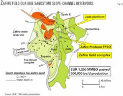
By 1993 UMC had identified Zafiro as its leading prospect and brought Mobil in to drill and develop the field as its 75% interest partner. Following its discovery in March 1995 (Fig. 2), Zafiro field came on line at 35,000 b/d in August 1996 and was initially believed to contain recoverable reserves of 180 million bbl of oil.
The story grows
Today, Zafiro field reserves stand at 1.2 billion bbl recoverable and the field is producing 300,000 b/d for ExxonMobil and Devon (acquired UMC's interest).
Marathon's Alba field has reported reserves of at least 5 tcf and 300 million bbl of condensate (reserves as high as 7 tcf and 600 million bbl are cited) and will be producing 70,000 b/d of condensate and liquefied petroleum gas following completion of Marathon's Phase 2A and 2B expansion programs in the fourth quarter of 2004.
Marathon continues to explore for gas reserves, with its latest dry gas find at the Bococo prospect 6 miles west of Alba field in 2003.
Addax has increased production in OPL 98 from 6,000 b/d to over 40,000 b/d, with current estimated reserves of 200 million bbl of oil. By 2007, Addax plans to drill more than 30 additional wells, building offshore facilities for five new fields, install a new central processing unit, and commission a new marine buoy to improve crude oil export capabilities.
ExxonMobil expects to raise its OML 67-70 Nigerian oil production 110,000 b/d above its current 750,000 b/d by 2006 when its additional oil recovery (AOR) project is due to start up, at a cost of around $1.7 billion.
Perenco acquired a new 3D seismic survey over the Moudi Permit in 2003, and Sovereign Oil & Gas brought Nexen Inc. into Oriental's OML 115, where a new blockwide (61,000 acre) 3D seismic survey is under way in preparation for a 2004 drilling campaign.
Golden Rectangle hydrocarbon system
Niger Delta deposystems
During early Eocene and subsequent regressive phases, a series of westerly-oriented, growth fault-bounded compartments formed.
These compartments underwent basinward gravity gliding along overpressured basal shear zones in deepwater Akata shales deposited as bottom-set beds to the Agbada formation.1 Figs. 3 and 4 depict the major components of the Mio-Pliocene depobelt and their relationships with several large petroleum accumulations in the Golden Rectangle.
In northerly updip areas, shallow water delta-front sandstone deposition predominated along extensional deltaic growth faults that formed near the active shelf margin in each compartment.

null
In middip areas, slope shale and channel sand deposition predominated in the middle portion of each compartment while it translated basinward along its overpressured basal detachment surface. Middip deposition was significantly influenced by local shale diapirism. Along the southerly downdip end of each seaward-sliding compartment, the basal detachment zone ramped stratigraphically upward, forming an imbricate series of compressional toe-thrust anticlines in megathrust sheets that developed beneath the lower continental slope and rise.
The middle and outer zones of these compartments were separated by major up-to-the-basin normal faults that formed at the backside of the toe-thrust complex as shale withdrawal occurred in this area. The overall structural configuration of the toe-thrust anticlinal sequence was that of a triangular shaped prism comprised of duplexed, toe-thrusted anticlines.
The Neogene submarine canyons that incised these lower slope deformed zones became coarse-grained clastic conduits for large aggradational channel-levee systems that formed at the base of the slope (e.g., the Isongo amalgamated channel complex in the Alba field area, Fig. 4).
The Edop-Zafiro Canyon, the largest of these submarine canyons, formed in the transfer zone between two mega toe-thrust sheets. This submarine canyon became the main coarse-grained conduit for fan systems that formed down dip on the Mio-Pliocene continental rise at Turquesa-1 and farther seaward on the abyssal plain north of Sao Tomé and Principe.
Cenozoic Niger Delta basin
Following a major late Paleocene marine transgression, an episodic regression started during the late Paleocene or early Eocene.2
During this time the Niger Delta began its long progradational march to the south. Although broken by lengthy transgressive phases, this overall sedimentary regression has continued in an oscillatory manner from the Late Paleocene to the Recent.
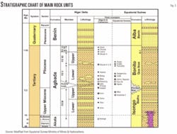
In Nigeria the bottom-set shale beds to this diachronous deltaic progression are called the Akata formation, and the associated marginal marine foreset beds, and continental topset (or delta platform) beds of these individual deltaic units are called the Agbada and Benin formations, respectively (Fig. 3). In Equatorial Guinea these three time-rock units are roughly correlative with the Isongo, Bonito, and Alba formations, respectively.
Throughout most of the Niger Delta sedimentary prism, Agbada formation sandstones contain the bulk of the oil and gas discovered to date. Intraformational shales usually provide vertical reservoir seals (cap rocks), and lateral seals via clay smear zones or juxtaposed shales across fault planes.
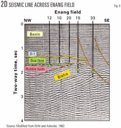
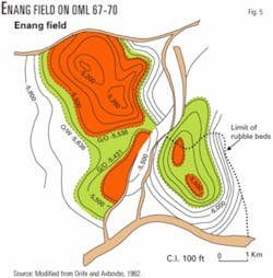
In southeastern offshore Nigeria, the Middle and most of the Upper Miocene portions of the Agbada formation are called the Biafra member. Farther south in Equatorial Guinea, the lower portion of the Biafra member is represented by the Isongo formation (Fig. 3). Mio-Pliocene conglomeratic beds have been drilled between the Biafra member and the Qua Iboe member in Nigeria.3 These conglomerates are called the Rubble Bed member of the Agbada formation and are oil productive in Enang field in OML 67-70 (Figs. 5 and 6).
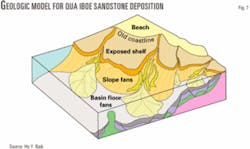
The Qua Iboe member, which represents an outer shelf and slope member of the Agbada formation in Nigeria and Equatorial Guinea, is mainly comprised of shales and slope-channel sandstones (Fig. 7). Until recently, Qua Iboe sediments in Equatorial Guinea were called the middle member of the Bonito formation. More recently, major discoveries in Qua Iboe-aged slope-channel sands in Zafiro field (Fig. 9) and in Alba field (Fig. 12), where they were formerly called Upper Isongo sands, have resulted in the updip Nigerian nomenclature being extended down dip into Equatorial Guinea.
Pliocene D-1 shelf sands were the last member to be deposited in the Agbada formation of Nigeria and Cameroon. In ExxonMobil's Okwok field (OML 67), these sands have been subdivided into Upper and Lower D-1 sandstone units and are separated by an intra-D-1 unconformity surface.
Hydrocarbon-filled D-1 sandstones are seismically represented by a continuous high amplitude reflection event. Lower D-1 sandstones are more lenticular and underlain by slope shales in Okwok field. To the east in Cameroon, D-1 sandstones are the main oil producing reservoirs, while to the south in Equatorial Guinea D-1 sandstone equivalents were the last Tertiary sediments to be deposited in the Pliocene Bonito formation.
In the Tsavorita-1 well (Block D), D-1 sands at –3,500 ft tested 1,800 b/d of 38º gravity oil and were immediately underlain by highly overpressured shale. The bulk of the hydrocarbon reserves produced to date from the Nigerian portion of the Golden Rectangle were pooled in sandstones deposited in the deltaic portions of the Biafra member and in the slope channel-fill sandstones of the Qua Iboe member (Fig. 3 and Table 1).
Most of the hydrocarbons produced in the Equatorial Guinean portion of the Golden Rectangle were pooled in either deepwater turbiditic sandstones of the Isongo formation (e.g., Alba field) or slope channel sandstones in the Qua Iboe member of the Bonito formation (e.g., the Zafiro field complex).
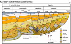
To date, Qua Iboe sandstones have not been a major hydrocarbon producing reservoir unit in Cameroon, although the play is gaining interest. Commercial oil and gas reserves also occur in the D-1 member sandstones and in the overlying sandstones of the paralic Benin formation. The general sense of reservoir provenance in the Golden Rectangle is shown in Fig. 8.
The ribbon-like Qua Iboe channel sandstone units are phenomenally productive where they have been drilled and average 100 ft in thickness. Their porosity percentages are often measured in the mid-30s with permeabilities measured in Darcies.
The excellent reservoir characteristics are probably a consequence of several factors: their quartz-dominated mineralogy; long residence in mildly overpressured environments that probably limited diagenetic effects; and their early hydrocarbon charge in a multisource, evaporative-fractionated petroleum system that has been generating and pooling hydrocarbons since at least the Neogene.
Basal Qua Iboe unconformity
Multiple world-class hydrocarbon accumulations have been discovered above and below a widespread late Miocene disconformity surface that formed when a large portion of the southern margin of the Niger Delta prism underwent catastrophic failure and slid oceanward around 6.3 million years ago (Figs. 3 and 4).
This catastrophic failure caused an extensive 30 to 40 mile (48-64 km) long, geologically instantaneous landward backstepping of the upper slope environment over a disconformity surface that formed along the Gulf of Guinea paleogeographic profile.4 This disconformity underwent further submarine erosion in Mio-Pliocene time and became a major upper Neogene unconformity surface that Mobil's geoscientists designated the Base of Qua Iboe unconformity (BQIU).
The critical effects that the formation of the BQIU and its subsequent associated deepwater deposition had on the southern Niger Delta petroleum system have been twofold.
First, the extreme narrowing of the southern Niger Delta shelf that immediately followed the Basal Qua Iboe middle and outer shelf failure eliminated the wide shelf profile that had existed in Biafra time.
As slope channels formed along the basal Qua Iboe failure surface, a connection was established between the wave-dominated and sand-rich Niger Delta front and the continental slope and abyssal plain to the south. These Mio-Pliocene channels gradually evolved into slope canyon systems that were backfilled with nested sandstone units and eventually covered with fine-grained clastics during Qua Iboe time.
Qua Iboe sandstones were often the first mildly overpressured reservoirs encountered by the upwardly migrating oil entrained in the evaporative-fractionated gas phase. As a consequence, medium to high API gravity oil exsolved in these sandstones and most of the remaining gas migrated farther up section into shallower Benin formation sands.
The second major effect that the formation of the BQI unconformity had on the southern Niger Delta petroleum system was the development of an overlying ubiquitous vertical shale seal that is often thousands of feet thick in the middip and downdip areas. The early formation of this mildly overpressured reservoir cap rock sequence has enhanced the underlying reservoir pressure systems and drive mechanisms in lower Qua Iboe and Biafra sandstones, even at relatively shallow depths.
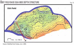
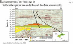
The vertical integrity of this mildly overpressured Qua Iboe shale seal has been demonstrated by the large shallow oil and gas accumulations pooled in the Qua Iboe sandstones that overlap the BQIU (e.g., the 1.2 billion bbl Zafiro field, Fig. 9) and the Biafra sandstones that subcrop below the BQIU (e.g., the 2 billion bbl Ubit field, Figs. 10 and 11).
Mildly overpressured Qua Iboe shales have often been drilled using 12-15 lb/gal mud weights and often contain temperatures high enough to preclude any microbial degradation of oil pooled in underlying Qua Iboe and Biafra reservoirs, even at depths shallower than 6,000 ft (1,828 m).
Trap development, hydrocarbon charge
From up dip to down dip, the bulk of the commercial hydrocarbon reserves discovered to date in the Golden Rectangle's depocenter (Table 1) have been found in traps involving:
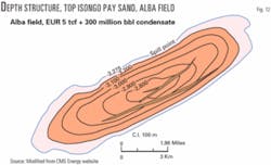
1. Doubly-plunging anticlines in lenticular Middle and Upper Miocene Isongo turbiditic sandstone reservoirs. These hanging wall anticlinal traps formed along the downdip toe-thrusted extremities of the depobelt. Since Isongo reservoirs are lenticular deposits, Isongo traps are not always coincident with the structural closure (e.g., Alba field, Figs. 3 and 12).
2. Single-plunging anticlines (combination traps) in Upper Miocene and Pliocene Qua Iboe slope-channel sandstone reservoirs. These traps are usually sealed laterally in one or more directions by overpressured shales across a submarine canyon wall and occur in the mid-dip (translational) portions of the depobelt (e.g., Zafiro field, Figs. 3, 7, and 8).
3. Doubly-plunging anticlines and upthrown fault traps in late Pliocene D-1 sandstones. These traps occur in the mid-dip portions of the depobelt and are usually associated with shale diapirism (e.g., Okwok field in OML 115, Figs. 3 and 4).
4. Paleogeomorphic traps where erosional incision has occurred in Biafra sandstones subcropping at the Basal Qua Iboe unconformity surface. These reservoirs are sealed vertically and laterally by Qua Iboe slope shales in mid-dip portions of the depobelt (e.g., Iyak, SE Iyak, and Utue fields in OML 67, Fig. 3).
5. Unconformity-enhanced, doubly-plunging anticlines in Miocene Biafra sandstone reservoirs. These traps occur in the middle to updip portions of the depobelt (e.g., Ubit field, Figs. 3, 10, and 11).
6. Doubly-plunging downthrown anticlines in growth fault expanded Biafra and Qua Iboe sandstone reservoirs. These traps occur along the updip (northern) margin of the depobelt (e.g., Adanga field, Fig. 4).
Minor hydrocarbon accumulations (those with EUR less than 100 million bbl) have also been found in faulted-nose traps in Biafra and Qua Iboe sandstone reservoirs in the updip and mid-dip portions of the Mio-Pliocene depobelt. The largest of these have been sealed laterally by fault-juxtaposed overpressured shales in their contiguous downthrown blocks and occur along the northern margin of the Golden Rectangle.
In the greater Niger Delta the upward migration of Paleogene-sourced oils appears to have occurred mainly along faults, with maturity decreasing away from the major bounding fault within each depobelt. This pattern implies that the major bounding faults act as migration conduits that feed deeply sourced hydrocarbons into shallower shale-sealed reservoirs.1 4
Migration has probably also occurred along and across the BQIU, especially where deeply incised submarine canyon walls separate mildly overpressured Qua Iboe sediments within the canyons from severely overpressured Isongo and-or Akata formation sediments that form the canyon's walls (e.g., Zafiro field). The oil field distribution in the Golden Rectangle appears to support these statements.
Systemic changes in gas-oil ratios described by others5 in the OML 67-70 joint venture acreage off Nigeria appear to continue southward into Equatorial Guinea. Specifically, hydrocarbon accumulations tend to be more liquid prone with depth, based on the bubble point of the fluids in the reservoirs that have been drilled and tested in normally pressured sediments. Although reservoir fluid contacts are often controlled by leaking seals in the Class III traps6 that prevail in normally pressured sections (e.g., Zafiro field), the potential exists for Class II filled-to-spill traps in the deeper overpressured rocks of the Akata and Isongo formations.6
References
1.Haack R.C., et al., "Niger Delta Petroleum Systems, Nigeria," in M.R. Mello and B.J. Katz, eds., "Petroleum Systems of South Atlantic Margins," AAPG Memoir 73, 2000, pp. 213-231.
2.Doust, H., and Omatsola, E., "Niger Delta," in J.D. Edwards and P.A. Santagrossi, eds., "Divergent/passive margin basins," AAPG Memoir 45, 1990, pp. 201-238.
3.Orife, J.M., and Avbovbo, A.A., "Stratigraphic and Unconformity Traps in the Niger Delta," in M.T. Halbouty, ed., "The Deliberate Search for Subtle Traps," AAPG Memoir 32, 1982, pp. 251-264.
4.Kean, A., "Utilization of 3-D Seismic in Visualizing and Reinterpreting an Unstable Shelf Area and its Relationship to Turbidite Deposition Downdip, Offshore Nigeria," in "Submarine Fans and Turbidite Systems," GCSSEPM 15th Annual Research Conference, Dec. 4-7, 1994, edited by Paul Weimer, et al., pp. 167-176.
5.Matava, T., et al., "Migration Effects on the Composition of Hydrocarbon Accumulations in the OML 67-70 Areas of the Niger Delta," in AAPG Bull., Vol. 87, No. 7, July 2003, pp. 1,193-1,206.
6.Sales, J.K., "Seal Strength vs. Trap Closure—a Fundamental Control on the Distribution of Oil and Gas," in R.C. Surdam, ed., "Seals, Traps, and the Petroleum System," AAPG Memoir 67, 1997, pp. 57-83.
Bibliography
Baik, H.Y., "A Schematic Diagram of Qua Iboe Deposition, Gulf of Guinea," 2004.
CMS Energy, Map of Alba Field, Equatorial Guinea, internet website, 2001.
Cooley, T.W., Nwaeri, E.U., et al., "Horizontal Well Redevelopment of the Giant Ubit Field, Offshore Nigeria," in abs. of the Second Wallace E. Pratt Memorial Conference, Jan. 12-15, 2000, 2 pages and 2 figures.
Equatorial Guinea Ministry of Mines and Hydrocarbons, Stratigraphic Chart of Eastern Nigeria and Equatorial Guinea, internet website, 2004.
UMC Media Presentation, Map of Zafiro Field, Equatorial Guinea, 1998.
The authors

Joe Bruso ([email protected]) directed United Meridian Corp.'s worldwide exploration program and discovered the Zafiro field. He is now president of Sovereign Oil & Gas Co., whose recent projects include leading Vanco Energy Co. into Block K in Equatorial Guinea and Nexen Inc. into OML 115 in Nigeria. He holds a BS in geology with graduate work in geophysics from the University of Houston.

Steven L. Getz became an independent prospect generator and consultant after 9 years as a geophysicist with Cities Service Oil Co. In the past 25 years his work has resulted in the discovery of more than 2 billion bbl of oil. He has a BS in geology from the University of New Mexico.

Ron Wallace is a senior geologist at Vanco Energy and was formerly vice-president of operations at Sovereign Oil & Gas responsible for technical evaluation and upstream marketing. He has discovered 1.6 billion bbl of oil. He holds a BS in geology from Youngstown State University and an MS in geophysics from Kent State University.