Aerial magnetic reconnaissance technique finds leads in Morocco
Skidmore Energy Inc. ventured into Morocco with a goal of achieving a successful "wildcat" oil and gas exploration program through the use of patented sedimentary residual magnetics (SRM) technology.
Skidmore Energy, a private Texas company founded by Michael H. Gustin and John Paul Dejoria, had successfully used SRM technology in South Texas and the Gulf of Mexico before venturing into Morocco.
SRM technology, developed by Geoscience & Technology Inc., is an aerial magnetic reconnaissance exploration tool used to identify potential hydrocarbon leads. The hydrocarbon leads are termed "magnetic bright spots" (MBS), also patented. Following identification of MBS leads, seismic is acquired, the prospect is developed, and a drill site is chosen.
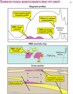
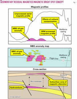
The association of shallow subsurface magnetic anomalies above oil and gas fields has been investigated for decades (Fig. 1). The cause of the shallow subsurface magnetic alteration is linked to hydrocarbon microseepage.
The exact process of the hydrocarbon-induced alteration is uncertain. However, many statistical studies prove the empirical relationship of oil and gas fields to these magnetic anomalies. For instance, a recent third party study of 97 MBS-based exploration wells in the Gulf of Mexico indicated a 97% success rate with 94 new field discoveries.
Standard data processing methods do not attempt to isolate and measure the small magnetic effects created by the shallow subsurface magnetic mineral bodies. Most analyses of magnetic data use filtering and averaging techniques to focus on variations in and derivatives of the earth's magnetic field, primarily the magnetic effect of the basement sediment. Any filtering or averaging of the magnetic data corrupts the amplitude of the MBS anomalies.
SRM is a proprietary advanced magnetic data processing technique that removes the basement effect without filtering or averaging the data. The result of the SRM processing is preservation of the MBS amplitude (Fig. 1).
Exploration program
Skidmore analyzed data provided by Onarep, the Moroccan national oil company, to identify potential areas/basins for SRM surveying.
The potential areas were chosen on the basis of numerous reports and studies completed by previous exploration companies. The information in the reports and studies includes regional tectonics, basin history and geological architecture, stratigraphy and sedimentation, source and reservoir rock potential, basin (hydrocarbon) modeling, subsurface and seismic data, and previous exploration successes and failures.
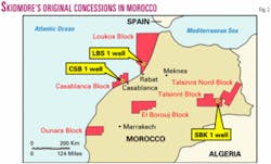
Skidmore ultimately signed six reconnaissance licenses that covered more than 9 million acres for the following blocks (Fig. 2):
Casablanca (offshore Doukkala basin).
El Borouj (onshore Tadla basin).
Loukos (offshore basin).
Ounara (onshore Essaouira basin).
Talsinnt (onshore High Plateaux basin).
Talsinnt Nord (onshore High Plateaux basin).
Skidmore acquired and SRM processed more than 80,000 line miles of aerial magnetic data on the six blocks (traverse line spacing of 1/6-1/4 mile and a tie line spacing of 11/2 miles). Upon highgrading the MBS data, Skidmore chose the following three areas to develop prospects:
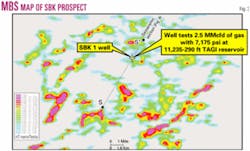
SBK Prospect, Talsinnt Block (Fig. 3).
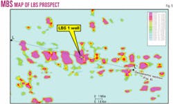
LBS Prospect, Loukos Block (Fig. 5).
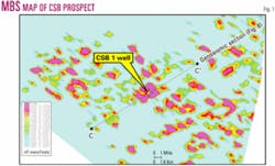
CSB Prospect, Casablanca Block (Fig. 7).
The mapped MBS anomaly intensities range from low (blue) to high (magenta).
SBK Prospect, Talsinnt Block
The Talsinnt block is located in the High Plateaux basin on the northern edge of the Atlas mountains.
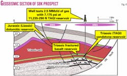
The dominant structural component is an inverted rift basin. Minor structural features include compressional/ thrust faulting with halokinetic movement. The SBK prospect is an anticlinal structure in a large half graben (Fig. 4).
The main objective reservoir is the Triassic sandstone, which correlates to the prolific TAGI reservoir in Algeria, sealed by salt/anhydrite. The source rock is considered to be the "hot" Silurian black shale, the dominant source rock in North Africa.
Only three wells have been drilled in the basin, 30-60 miles northeast of the SBK prospect, that tested the Triassic sandstones. AGIP drilled the TE-1 and TE-2 wells in 1966 to 1967. Onarep drilled the TE-3 well in 1985. All three wells had slight gas shows in the TAGI formation, were never tested, and subsequently were plugged and abandoned.
The SBK-1 well, drilled in mid-2000, encountered the TAGI formation productive at 11,235-290 ft. Completion of the TAGI reservoir resulted in a well producing gas at the rate of 2.5 MMcfd at 7,175 psi. Subsequent seismic inversion analysis indicates the SBK-1 well was drilled on the edge of the reservoir.
Based on extended reservoir testing and seismic mapping, the SBK prospect has 1,500 acres of closure with a potential recoverable estimate of 65 MMboe.
Based on an offset vertical seismic profile, SBK-1 drilled into the attic position of a minor downthrown fault block. The extended well testing indicated gas with minor liquids, but subsequent seismic inversion processing indicated a probable oil reservoir with associated gas in the major upthrown fault block.
Additional shows and testing indicate two other potential reservoirs, the Triassic "fractured" basalts and the Jurassic dolomites. Minor testing of the basalts indicated a light oil of 38-39° gravity. Shows in the dolomites indicated probable oil.
LBS Prospect, Loukos Block
The Loukos Block is located in a western extension of the onshore Rharb basin.
The dominant structural component is a simple monocline dipping to the north. Minor structural features include shale/salt diapirs and compressional/ extensional tilted fault blocks.
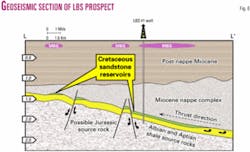
The monocline formed during the Alpine orogeny (mid-Miocene) with thrusting of a thick nappe sediment wedge. The LBS prospect is a horst block structure with an updip fault/stratigraphic combination trap (Fig. 6).
The main objective reservoirs are the Cretaceous sandstones sealed by the Miocene nappe sediment. The source rock is considered to be the Albian and Aptian marls/shales. Greater Oficina field in Venezuela is considered to be an analog field to the LBS prospect with respect to reservoir rock and age, source rock and age, structural and stratigraphic style, trap, and seal.
Only one well had been drilled within the acreage of the entire Loukos block, and that well only tested the post nappe Miocene prior to mechanical failure.
The LBS-1 well, drilled in late 2000 to early 2001, encountered the Cretaceous sandstones possibly productive at 10,115-205 ft. Mud log shows and log analysis indicate a potential oil reservoir.
The well was cased but neither perforated nor tested. Seismic mapping indicated a closure of 2,525 acres with a potential recoverable estimate of 85 MMboe.
CSB prospect, Casablanca Block
The Casablanca Block is located in a northwest extension of the onshore Doukkala basin. The dominant structural component is a large prerift anticline.
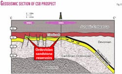
Minor structural features include extensional fault blocks. The CSB prospect is a faulted erosional feature on the flank of a large anticline (Fig. 8).
The main objective reservoirs are the Ordovician sandstones sealed by the Triassic salt/red beds. The source rock is considered to be the "hot" Silurian black shale.
No wells are drilled within the acreage of the Casablanca block.
Original work by Texaco in 1989 indicated a large anticlinal structure with a closure of more than 130,000 acres and comparison to the giant Hassi Messaoud gas/oil field in Algeria (Hassi Messaoud produces from the Cambro-Ordovician sandstones on the crest of a large anticline).
Texaco's comparison was based on all aspects of Hassi Messoud field, including reservoir rock and age, source rock and age, structural and stratigraphic style, trap, and seal.
The MBS map indicates the CSB prospect is a truncated flank play on the anticlinal structure. MBS and seismic mapping indicate the flank play covers 45,000 acres with a recoverable estimate of 400-500 MMboe.
Summary
Morocco's exploration history is sporadic and minimal.
This is due to several factors, primarily a lack of initial success with early exploration efforts and subsequent abandonment of drilling programs as surrounding countries established large commercial oil-gas reserves and expanded exploration programs. Additional factors include complex geology, source rock distribution, and hydrocarbon generation/migration.
Morocco has 12-15 sedimentary basins with numerous potential structures and traps worth exploring. Therefore, the question remains, "where to explore in Morocco?"
Skidmore's utilization of SRM technology in Morocco demonstrated the ability to successfully locate commercial oil and gas with MBS hydrocarbon leads. SRM technology mitigated exploration risks and provided focused exploration by being able to identify potential prospects, prove petroleum systems, and reduce seismic expenses.
Bibliography
Donovan, T.J., et al., "Aeromagnetic detection of diagenetic magnetite over oil fields," AAPG Bull., Vol. 63, 1979, pp. 245-248.
Foote, R.S., "Use of magnetic field aids oil search," OGJ, Vol. 9, No. 18, 1992, pp. 137-142.
Foote, R.S., "Relationship of near-surface magnetic anomalies to oil and gas producing areas," AAPG Memoir 66, 1996, pp. 111-126.
Foote, R.S., Nowak, R., and Sobehrad, J., "Aeromagnetic near-surface profiling as an exploration tool," Applications of Emerging Technologies, Vol. V, 1997, pp. 183-189.
Burazer, M., et al., "Magnetic data processing for hydrocarbon exploration in the Pannonian basin," Geophysics, Vol. 66, No. 6, 2001, pp. 1,669-79.
Liu, Q., et al., "Relationship between magnetic anomalies and hydrocarbon microseepage above the Jingbian gas field, Ordos basin, China," AAPG Bull., Vol. 88, No. 2, 2004, pp. 241-251.
Note: additional information of SRM/MBS technology is available (www.cssworldwide.com).
The authors
John Sobehrad ([email protected]) is an independent consultant and owner of the company Geo-Logic. He began his career in the late 1970s and has held positions from well site geologist to chief geologist and president. His experience has been onshore in Texas, Oklahoma, and Montana. Offshore experience includes the Gulf of Mexico for companies such as Maxus, Union Texas Petroleum, and Total. He has a BS in geology from the University of Wisconsin-Eau Claire.
Robert S. Foote Sr. is owner of Geoscience & Technology Inc. For more than 20 years, he has developed and subsequently patented SRM technology. Before originating the method, he worked with Texas Instruments' seismic division and with Geodata International. He was responsible for operations directed toward oil, gas, and mineral exploration. He has a BS and MS in physics from the University of Illinois and a PhD in physics from the University of Maryland.
