Australia making new initiatives for greater exploration data access
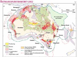
Australia contains established oil and gas provinces (Fig. 1), is politically stable, and has a fiscal regime that encourages petroleum exploration and development.
These combined with infrastructure all serve to attract and maintain petroleum exploration and production investment in the established oil and gas provinces. In the last 10 years, Australia has maintained 65-85% self sufficiency in oil and better than 100% sufficiency in gas as a net gas exporter through LNG.
The Australian government has a new program of data acquisition in poorly explored areas, and the recently announced Spatial Information & Data Access Policy requires that basic data be made available at the marginal cost of transfer or free if delivered via the internet.
In addition, to encourage exploration in its many underexplored regions, Australia has traditionally maintained better access to geoscience and petroleum exploration data than almost anywhere else in the world.
Access to petroleum exploration information has been facilitated by legislation requiring data submission and availability and by the provision of precompetitive studies by government agencies. This is coupled with an aggressive, globally and yearly promoted, acreage release program.
Australia remains significantly underexplored and for that reason has sought to improve the very high level of access to exploration and production data that includes seismic data, well information, and regional geological studies. Ease of access is designed to attract new explorers.
Australia has less than 8,000 oil and gas exploration wells onshore and offshore in an area of over 12 million sq km and, consequently, there is considerable opportunity for further exploration.
Significant discoveries of oil and gas have occurred in Australia since the 1960s and continue to the present day. Supergiant oil and gas fields have been discovered both in the southeast and northwest parts of the country.
Globally, Australia ranks 27th as an oil producer and 18th as a gas producer. Although underexplored, already it is assessed as containing upwards of 2% of the world's gas reserves and 1% of the world's oil reserves.
Recently, deeper water exploration (>1,200 m) has occurred in Australia adjacent to major gas and oil production in the Carnarvon basin and to major discoveries in the adjacent Browse basin on the Northwest Shelf.
Significant deepwater oil discoveries at Laverda, Vincent, and Enfield of over 200 million bbl have been made in the Carnarvon basin, and many tens of trillions of cubic feet of gas have been discovered at Gorgon and deepwater fields farther to the west.1
Superior availability of data
Australia is one of the best worldwide in providing petroleum exploration and production data to potential and current explorers, according to independent assessments.
The Review of the Role of the Commonwealth Government in Offshore Petroleum Exploration2 also reported that companies agreed that access to data was better in Australia than elsewhere internationally.
An absence of such a framework was considered by definition to reduce perception of prospectivity and to increase exploration risk. This view was supported by the ACIL Report on prospectivity,3 in which industry respondents agreed that easy access to significant quantities of credible data was an element of Australia's competitive advantage.
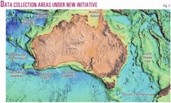
An even higher level of effort to make Australian petroleum exploration and production data available to current and potential explorers was announced in the Commonwealth Government Budget Decision of May 2003. This decision announced new funding which will be used over 4 years to provide vital geological and seismic data to companies considering oil exploration in Australian waters (Fig. 2).
Industry has greeted the decision as a vital step in enhancing the attraction of Australia as a place to invest in petroleum exploration. The article also addresses current availability of petroleum exploration and production data in Australia for potential explorers.
New initiatives
The Australian government in its May 2003 budget announced new funding to be used over 4 years to provide important geological and seismic data to companies considering oil exploration in Australian waters.
The government acknowledged that 90% of all oil exploration success in Australia since the 1960s has been directly underpinned by geoscience information and advice given by Geoscience Australia, or its forerunner, the Bureau of Mineral Resources (BMR).
Australia needs to find a new Bass Strait with supergiant fields, as discovered in the 1960-70s. This is because current crude oil and condensate reserves are insufficient to sustain the present level of production in the medium term. That is, recent oil discoveries have not been sufficient to meet the decline in oil production from the larger fields and in particular those in the Gippsland basin.
Estimates of future production of oil and condensate suggest that at the mean expectation production rates would drop by 33% by 2005 and 50% by 2010 as a result of a decline in oil production. The forecasting included production from fields that had not yet been discovered.
Condensate production was projected to continue to grow, but the rate of growth is tied to gas production rates and overall by the development timetable for the major gas fields. Consequently, the rate of discovery of new oil fields is insufficient to replace oil reserves that are being produced.
The conclusion is that exploration will need to diversify to frontier basins that could contain big new oil provinces, but at the same time there is a need to fully explore the already known oil provinces.4
To assist industry in this new search, the Australian government is providing substantial support by making information available at marginal cost or for free.
Funding is also being provided to enable the copying up to half a million seismic tapes held by Geoscience Australia onto modern storage media. This preservation is necessary to ensure valuable seismic data are not lost because of the deterioration of old technology tapes.
Also, the government allocated $25 million for the collection of new data to further stimulate exploration and to allow remastering of the seismic data in the Geoscience Australia Repository.
The budget initiative also allows for the collecting of new data to promote petroleum exploration in areas that could provide the possibility of major new oil provinces.
Consultation has been undertaken with the Australian and international petroleum exploration industry to identify areas that show the greatest potential to contain large undiscovered oil reserves. Areas have been defined in the south, west, and east of Australia (Fig. 2).
The new data sets will range from seismic data to geological and geochemical sampling to confirm evidence of active petroleum systems, indicated by remote sensing techniques, including synthetic aperture radar, seismic, and bathymetric features.
The aim of the precompetitive surveys is to establish that a suitable geological history has occurred for large oil accumulations to have been formed and that oil is actually present in the area. The targeted areas for the studies range from shelfal depths to deep water.
The likelihood of this program to succeed is helped by the very low level of exploration around Australia with less than 8,000 wells drilled to date. The data collected by Geoscience Australia for this initiative will be inputs to ongoing regional studies.
Areas for studies by Geoscience Australia have been prioritized, and survey data will be acquired over these areas over the next 4 years. The results of the precompetitive studies will be available for explorers to assess the prospectivity of acreage in the regions made available for bidding under the work program bidding system in Australia.
The initial work will be to study oil seeps and their signatures on the Northwest Shelf and collect geophysical data and seabed samples from the deepwater Bremer subbasin on the southern margin (Fig. 2).
Funding will also allow for the copying onto modern storage media of seismic data on up to 500,000 field tapes held by Geoscience Australia. A significant part of the budget ($10 million) has been allocated to remastering seismic data largely from among the 400,000 seismic tapes on old media prior to the introduction of 3480 cartridge tapes, and 3480 tapes if funding is available.
The bulk of the pre-3480 cartridge data are on 9-track tapes, and most of the remainder are on 21-track tapes. The priority will be to remaster the 9-track tapes because some of these are affected by stiction that threatens loss of data.
The data will be preserved to 3590 cartridges. Two copies will be made, one as a primary copy and one as backup. Thus this preservation will not only ensure the data are not lost because of deterioration but will also make the data more readily available to potential explorers. Remastering of data began in December 2003.
The program to remaster the data will continue to mid-2007. The remastering of the data will make it much more readily available to the exploration industry. It will also reduce greatly space pressures on storage of data in the Geoscience Australia Repository.
The industry capability to remaster the data is well established in Australia due in part to the large amount of borrowing of seismic data for reprocessing that is undertaken under the provision of the Petroleum Submerged Lands Act. It is expected that this program of copying to high density media will greatly improve the already very good access to seismic field data in Australia.
Basis of data access
The Petroleum Search Subsidy Act, introduced to stimulate oil and gas exploration in Australia, first established superior data access for explorers.
It provided subsidies for exploration activities both onshore and off Australia. A requirement of the Petroleum Search Subsidy Act was that data were lodged with government with the predecessor of Geoscience Australia, the BMR, to be made available for future explorers.
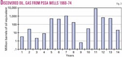
During the term of the Petroleum Search Subsidy Act from 1957 until 1974, the current major petroleum producing basins in Australia were discovered including supergiant oil and gas fields (Fig. 3).
In 1967 subsidies for exploration were removed in the Petroleum (Submerged Lands) Act. The requirement to lodge data, however, remained. The PSLA covers offshore Australia outside of 3 nautical miles from the coastline. Onshore and to 3 nautical miles offshore, Australian state governments have legislation that largely mirrors the PSLA.
As new types of petroleum data have emerged, the requirements for data lodgement under the PSLA have been modified to reflect current industry practice. Guidelines for lodging petroleum data are available on the Geoscience Australia Web site (http:// www.ga.gov.au).
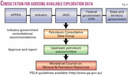
The requirement for lodgement of petroleum data is decided by the Upstream Petroleum Sub-Committee. Advising that subcommittee is the Petroleum Consultative Data Group (PCDG), comprising representatives from Australian Petroleum Production & Exploration Association (APPEA), industry, the International Association of Geophysical Contractors, the states and Northern Territory, and the Commonwealth Department of Industry, Tourism & Resources. The Consultative Group is chaired by Geoscience Australia (Fig. 4).
Exploration data are submitted by explorers and contractors and made available after a short period of "confidentiality," normally 1-3 years for basic data and 5 years for interpretive data. Basic data are considered to be those which an explorationist would expect to have available in assessing acreage and include, for example, well and seismic data.
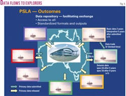
Geoscience Australia stores, manages, and loans the data to industry for the marginal cost of transfer (Fig. 5). Geoscience Australia also uses the data to carry out precompetitive studies to promote petroleum exploration in Australia.
Borrowing of seismic data from Geoscience Australia can be done over the worldwide web via http://www.ga .gov.au. Data can also be viewed and studied on site at the Geoscience Australia Repository.
The data are managed under the terms the National Petroleum Information & Database Strategy formulated by the PDCG. The strategy and associated guidelines for submission of petroleum data aim to promote national standards to mirror worldwide industry standards in data formats and media and to cooperate with companies storing data in locations such as data banks and industry storage facilities.
The Commonwealth Spatial Information & Data Access Policy in 2001 made a broad range of data publicly available for the costs of transfer. Thus, a good deal of the data is now almost free to industry and includes data from extensive digital data bases that can be accessed online by the web.
Information and data
Geoscience Australia carries out regional studies to provide information on acreage that is made available for gazettal early each year at the APPEA Conference.
The studies are developed in consultation with the industry and include such subjects as source rock assessment, oil and gas characterization, and studies of stratigraphy, petroleum systems, and structure of prospective regions.
The ACIL Report3 showed that 85% of industry interviewees supported the role of government in both collecting data and undertaking basic research and that Geoscience Australia's data were being used by nearly all companies.
Examples of the effectiveness of Geoscience Australia's survey and research include stimulation of exploration in the Perth basin in the early 1990s,5 worth about $200 million.
Additional evidence of stimulating new rounds of exploration in other areas originally considered unprospective include the Otway basin, leading to significant commercial gas discovery, and the Exmouth plateau, where deepwater exploration was undertaken adjacent to proven areas.
Since 1998 permits have been awarded in deepwater frontier areas in the Browse, Exmouth, Abrolhos, and Great Australian Bight basins. The regional lines that Geoscience Australia acquired around the continental shelf together with industry speculative and open file data helped identify and stimulate interests in a number of these areas.
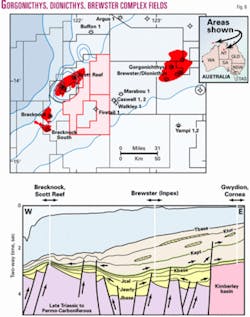
The major Japanese company Inpex discovered a gas-condensate resource in the Browse basin estimated at 10 tcf of gas and 500 million bbl of condensate in the Gorgonicthys, Dionicthys, Brewster complex (Fig. 6). Inpex credits Geoscience Australia's study of the Browse basin as being instrumental in its bidding for the Browse basin acreage on the Northwest Shelf.
Geoscience Australia and state and federal colleagues use such regional petroleum geology and specialist studies and other data to promote the frontier areas during promotion of gazetted exploration release acreage. Other recent examples of Geoscience Australia contributing to exploration are given in Williamson and Foster.6
Specialist studies include oil-source correlation geochemistry, potential field studies, and timescales research. The latter is part of the Virtual Centre of Economic Micropaleontology & Palaeontology (VCEMP) to improve biostratigraphic correlation in Australia. Limited onshore studies are carried out normally in conjunction with states and the Northern Territory.
Available Geoscience Australia publications on these studies can be viewed at GACat (www.ga.gov.au).
Accessible oil and gas exploration and production data include well completion reports, geophysical survey reports (including seismic surveys) submitted by industry, digital data bases, and reports on studies by Geoscience Australia. Data from the Australian states and Northern Territory can also be obtained from the relevant capitals. These data along with data from Geoscience Australia can be accessed via a central Geoscience portal (www.geoscience .gov.au).
Available rock samples include about 3,000 km of downhole drill cuttings and 150 km of cores, sidewall cores, thin sections, and reservoir plugs. Cores and cuttings are from 716 PSSA and 1,250 PSLA wells and from Geoscience Australia onshore stratigraphic wells. Along with rock samples, oil samples from wells and gas samples from some wells are also available under the PSLA. In 2001-02, 70 km of cores and cuttings from 54 PSLA wells were submitted to the repository.
Seismic reflection data in the repository include digital field tapes and processed data and hard copy processed sections. The data come from the surveys carried out by industry under the PSLA and PSSA and also from the Geoscience Australia Continental Margins Programs.
Current media for field tapes are 3590 cartridges. There are however, older media ranging from 21-track tapes up to 3480 cartridges. The new initiative involves an accelerated effort to migrate data to the more modern and higher density 3590 cartridges.
The field data can be borrowed from the repository and are used commonly for reprocessing using the newer seismic processing algorithms. Geoscience Australia holds about 400 terabytes of seismic exploration data. In 2003 alone, data from over 250 digital seismic surveys were borrowed comprising 10 terabytes of data.
There are 65,000 reports available for borrowing. These include well completion reports, geophysical survey reports and destructive analysis reports. For the older reports lodged as hard copy there is a program to convert these to digital forms.
Destructive analysis reports are available as a result of companies borrowing samples for destructive analysis, for example to investigate source rock properties. To help prevent destruction of all samples there is a requirement for companies to lodge the basic data from their destructive analyses within 6 months and that information be made publicly available to other explorers that may be interested in similar studies.
Digital data bases managed by Geoscience Australia include data bases on wells and seismic data (PEDIN), stratigraphy (STRATDAT), organic geochemistry (ORGCHEM), reservoir properties (RESFACS), Australian Petroleum Accumulations, and the Petroleum Information Management System (PIMS) which allows online borrowing of data from the repository. The data bases can be accessed on the worldwide web (www.ga .gov.au/oracle/apcrc).
Trends in data access
The most dominant current trend in data access is in allowing internet access to digital data and data bases.
Previously hard copy data sets such as well completion reports are also being scanned to digital formats so that they are more readily accessible, normally on CD. Also being scanned into digital form are hard copy observers' logs.
More recent data sets however, are already in digital form allowing for easy access. Data base access has now been extended to allow industry to add to Geoscience Australia data bases.
It is envisaged that in the future industry will be able to submit reports directly into Geoscience Australia data bases remotely via the web. Technologies such as XML which allow mapping from one data base to another are likely to make this trend easier and Geoscience Australia is eagerly awaiting the emergence of standards for XML petroleum data transfer.
The government is moving to make as much information web accessible as rapidly as possible. As mentioned above, the Australian Government Spatial Information & Data Access Policy of 2001 allows government-held digital data to be made available for the cost of transfer, and for the web this means at zero cost. These data include precompetitive studies by Geoscience Australia.
The second major trend in facilitating easy access to Australian Geoscience data is in the move towards a one-stop shop. This allows data sets from Australia's land and offshore regions to be accessed via one web location.
The Australian states and Northern Territory along with Geoscience Australia have combined in presenting Australian data via the one geoscience portal (www.geoscience.gov.au). This avoids confusion among explorers outside Australia in accessing Australian data in that it creates a virtual one-shop data repository for Australia. F
References
1. Longley, I.M., Bradshaw, M.T., and Hebberger, J., "Australian Petroleum Provinces of the 21st Century," in Downey, M., Threet, J., and Morgan, W., eds., "Petroleum Provinces of the 21st Century," AAPG Memoir 74, 2002.
2. Department of Primary Industry & Energy), "The Role of the Commonwealth Government in Offshore petroleum exploration and development," October 1997.
3. Department of Primary Industry & Energy, "Portfolio evaluation of the role of the Commonwealth Government in Offshore Petroleum Exploration and Development," October 1997.
4. Powell, T.G., "Understanding Australia's petroleum resources, future production trends and the role of frontiers," APPEA Journal, Vol. 41, Part 1, 2001, pp. 273-285.
5. Spring, D.E., and Newell, N.A., "Depositional systems and sequence stratigraphy of the Cretaceous Warnbro Group, Vlaming Subbasin, Western Australia," APPEA Journal, Vol. 33, Part 1, 1993, pp. 190-203.
6. Williamson, P.E., and Foster, C., "Access to Australian exploration and production data: a critical factor in attracting investment," APPEA Journal, Vol. 43, Part 1, 2003, pp. 693-704.
Bibliography
Department of Industry, Science & Resources), "Release of offshore petroleum exploration areas Australia," April 1999.
Geoscience Australia 2002, "Oil and Gas Resources of Australia 2001," Geoscience Australia, Canberra.
PSSA, 1957, "Petroleum Search Subsidy Act 1957," Commonwealth Government Printer, Canberra.
The authors

Paul Williamson (paul.wil- [email protected]) is group leader of the Petroleum and Greenhouse Gas Advice Group with Geoscience Australia. His interests have been in petroleum prospectivity analysis, the structure of continental margins, petroleum technical advice, and petroleum data management and access.

Clinton Foster ([email protected]) is acting chief of the Petroleum and Marine Division of Geoscience Australia (GA). He is also director of the Virtual Centre for Economic Micropalaeontology and Palynology (VCEMP) established in 2002 with GA, the British Geological Survey, and the University of Western Australia. His interests include timescales research, geochemistry, and data base development.