MADAGASCAR DEEPWATER—1: Deepwater basin confirmed far off western Madagascar
Ralph A. Stone
Xpronet Inc.
Houston
Samuel D. LeRoy
EarthView Associates Inc.
Houston
An evaluation of a portion of the deepwater Mozambique Channel in Madagascar territorial waters has been recently carried out by Xpronet Inc., Houston, in cooperation with l'Office des Mines Nationales et des Industries Stratégiques (OMNIS), the Malagasy government authority.
The regional geology, satellite gravity data, and a limited database of low-fold seismic data suggest that the Moron- dava basin could extend far offshore to the west and be a target for future deepwater hydrocarbon exploration. Xpronet and two industry partners joined TGS-Nopec Geophysical Co. in a test seismic program consisting of four reconnaissance lines, extending 300 km west from the Madagascar coast.
Results to date:
- 1.Confirmation of the existence of a sedimentary section 9-10 km thick lying in 2-2.5 km of water. Seismic and gravity data suggest that this section was deposited within a failed rift zone that lies midway between the basin-bounding Davie ridge and the west coast of Madagascar 200 to 300 km to the east.
- 2.Bathymetric highs of the Davie ridge trend are underlain by folded and faulted sedimentary section, apparently cored by evaporite and-or shale diapirs, at least within the limits of the newly acquired seismic data.
- 3.The Cretaceous volcanic rock sequences, present in wells just offshore from the western coast of Madagascar, are limited in areal distribution and do not uniformly blanket the area.
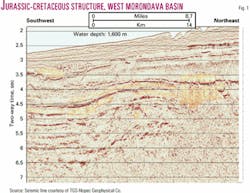
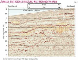
- 4.Multiple types of structures are observed in the data, and these are potential targets for oil exploration. The size of observed structures ranges from the large-scale Davie ridge trend fold complexes of 25-30 km apparent width, to simple dip reversal features on the order of 10-15 km wide (Fig. 1).
- 5.Reservoir rocks of Jurassic and Cretaceous age are inferred.
This is the first of two articles that describe the area.
Database, background
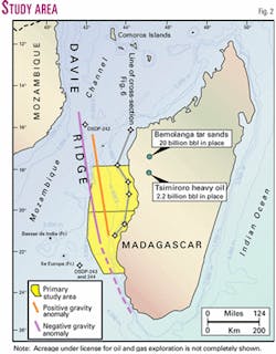
The study area is off the western coast of Madagascar (Fig. 2).
Drawn to the area by the multibillion barrel Bemolanga and Tsimiroro heavy oil sands and tar seeps, industry has carried out exploration and drilling campaigns in the onshore and adjacent shallow offshore in the past 50 years.1-5
Though western Madagascar has been explored without commercial success to this time, the Bemolanga-Tsimiroro near-surface accumulations provide evidence of a rich hydrocarbon system in rocks of Jurassic age.
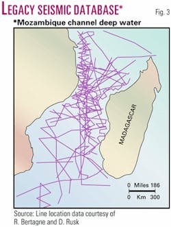
Seismic data from academic research institutions and the SEAGAP survey (a mid-70s industry consortium) suggested the presence of a sedimentary section in deep waters west of the Madagascar shelf break (Fig. 3).
- Though poorly imaged, the reflection sequences in the old data implied that there could be a folded and faulted sedimentary section of interest for oil exploration. Furthermore, the character of these early data suggested that localized evaporite or shale diapirs might be present.
- The Davie ridge trend of deepwater bathymetric highs, while explored in pursuit of answers to questions related to global tectonics, has apparently never been explored for hydrocarbons. This trend presents a regional-scale set of structural targets substantially different from past oil exploration work around Madagascar.
- The work by Coffin and Rabinowitz6-8 and others after them9 sets a useful plate tectonic frame of reference, relying on these legacy seismic data and accompanying gravity and magnetic data.
Satellite gravity data indicated differentiation, possibly with implications for exploration for hydrocarbons.
- In the vicinity of the Davie ridge (Fig. 2), a gravity minimum is present on the bathymetric highs, opposite of what would be ordinarily expected if the Davie ridge were a simple igneous feature.
- East of the Davie ridge, around half-way to the Madagascan shelf break, the satellite gravity data indicated a regional-scale positive trend in both free air and Bouguer data sets.
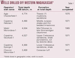
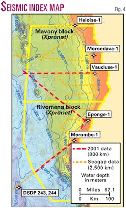
Two oil exploration drilling programs were carried out in 1970-71 and 1985 during which six wells were drilled in shallow waters in or near the study area (Figs. 2 and 4 and Table 1).
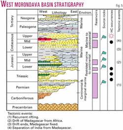
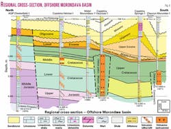
Fig. 5 summarizes the regional stratigraphic succession as understood from these wells and the literature. Fig. 6, a north-south regional cross-section that spans 600 km along the offshore western Madagascan shelf, portrays the localized stratigraphy—and relative complexity—in this area of sparse control.
The wells confirm that sandstones of Tertiary, Cretaceous, and Jurassic ages are present, in addition to an imprecisely described Triassic-early Jurassic sandy section near TD in the AGIP Chesterfield well. Note that this is a strike-oriented cross-section, and that basinward (i.e., westward, toward the viewer) facies changes will occur. Our interpretation is that these wells lie eastward from the margin of a failed Mesozoic rift zone.
Concurrently with our Xpronet study, Rusk, Bertagne & Associates (RBA) and TGS-Nopec10 carried out a study of the hydrocarbon potential of the greater Mozambique Channel, including the offshore and coastal areas of Madagascar, Mozambique, and southern Tanzania. Rusk and Bertagne have incorporated the results of 80 onshore and offshore wells and 30,000 line km of offshore seismic data (Fig. 3).
Expected to be completed in early 2003, the RBA-TGS-Nopec report will include 100 maps, cross-sections, and montages, plus text, forming a comprehensive review of the hydrocarbon potential of the entire Mozambique Channel.
Regional geologic setting
During late Carboniferous to early Triassic time, western Madagascar lay opposite Tanzania and Kenya, north of its present position. As the region underwent deformation by recurring rifting, Permo-Triassic Karoo formation continental and marginal marine sediments accumulated in localized rift basins, elongated north-south.
During mid-Triassic to mid-Jurassic, a new phase of rifting began, in which lacustrine sediments followed by marine clastics, carbonates, and localized salt deposits, accumulated in a northeast-southwest oriented rifted margin (Fig. 5). Multiple hydrocarbon source rock sequences were deposited within this succession, the Sakamena and Isalo formations, described by Radelli1 and Du Toit et al.4
The separation of Madagascar, India, and Antarctica from the African plate began in middle Jurassic and, with respect to Madagascar, was relatively short-lived, ending in early Cretaceous (spanning 165 to 130 Ma.).7 As Madagascar moved southward relative to Africa along the Davie fracture zone, a facies mosaic of marls and limestones overlain by sand-shale sequences developed along the westerly facing margin during late Jurassic through early Cretaceous time.
When India separated from Madagascar in the mid- to late-Cretaceous (Turonian-Coniacian), accompanying volcanic activity resulted in both intrusive and extrusive rocks being emplaced in the stratigraphic succession found in the wells in the study area (Fig. 6).
To our knowledge, no radiometric age determinations have been attempted on the rocks from the offshore section. Storey, et al.11 and Torsvik, et al.,12 used samples from surface outcrops, and show that the upper Cretaceous volcanism spanned an 8 million year period, 92-84 Ma (Turonian to Santonian).
Recent work by Torsvik et al.13 provides a further tie, linking this magmatic activity to the breakup and splitting off of India from the eastern side of Madagascar.
Regional geological data suggest that the greatest amount of igneous activity was focused on the eastern side of the island, some 450-700 km southeast of our study area.
The stratigraphic succession during the Tertiary has been dominated by carbonates and fine clastics, with local Oligo-Miocene sandstones deposited in the southern portion of the study area. There are multiple unconformities, particularly within the early Tertiary part of the section, related to continuing tectonic adjustments.
Though Africa and Madagascar are considered to be fixed relative to each other from the middle Cretaceous onward, nevertheless, post-tectonic movements have also been recognized by others (for example, Coffin and Rabinowitz6), consistent with the multiple unconformities seen in the well data.
Continental margin analysis
We carried out an analysis of the statistical variation in observed gravity data versus bathymetry/topography as a first step in evaluating the basement form, geometry, and crustal variation across this relatively complex continental margin.
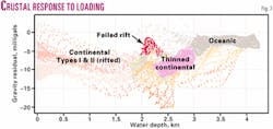
On older passive margins, such as those around Madagascar, a sediment-loading-topography-gravity trend line can be observed for oceanic crust. Residual gravity response away from this ocean crust trend line is used to interpret distribution of different crustal types via density contrasts in the rock section.
Differences between observed Bouguer gravity and those predicted from a simple loading model are used to concentrate interpretation efforts on the spatial distribution of crustal types and sediment fill.
The "base-case" model is built from the crossplot of Bouguer gravity and bathymetry, smoothed so that isostatic equilibrium can be reasonably assumed. In this case, a 300 km smoothing filter was applied in crossplot construction.
Initial simplifying assumptions are that:
- Bathymetric/topographic variations are due to sediment loading onto oceanic crust.
- The crust and mantle are near isostatic equilibrium.
Crossplot variations from the oceanic sediment-loading line arise from variations in crustal composition, thickness, and sedimentary density. When these observations are combined with regional seismic data and magnetics, accurate estimations as to crustal distribution and basin geometry can be made for continental margin settings (Fig. 7).
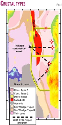
The results of this crustal type classification are displayed in the map view (Fig. 8).
This work strongly suggests that the west Morondava offshore area is underlain by thinned continental crust overlain by a sedimentary veneer. In contrast, oceanic crust is clearly present to the southwest.
Next week: Results from 800 line km of new reconnaissance seismic data and exploration findings.
